National Register of Historic Places listings in Van Buren County, Iowa
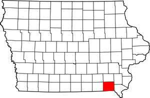
Location of Van Buren County in Iowa
This is a list of the National Register of Historic Places listings in Van Buren County, Iowa.
This is intended to be a complete list of the properties and districts on the National Register of Historic Places in Van Buren County, Iowa, United States. Latitude and longitude coordinates are provided for many National Register properties and districts; these locations may be seen together in a map.[1]
There are 20 properties and districts listed on the National Register in the county.
- This National Park Service list is complete through NPS recent listings posted December 16, 2016.[2]
| [3] |
Name on the Register[4] |
Image |
Date listed[5] |
Location |
City or town |
Description |
|---|
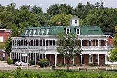
| 1 |
Aunty Green Hotel |
Upload image |
000000001978-01-20-0000January 20, 1978
(#78001265) |
602 Washington St.
40°41′55″N 91°48′01″W / 40.698611°N 91.800278°W / 40.698611; -91.800278 (Aunty Green Hotel) |
Bonaparte |
|
| 2 |
Bentonsport |
|
000000001972-04-25-0000April 25, 1972
(#72000482) |
East of Keosauqua on the Des Moines River
40°43′32″N 91°51′14″W / 40.725586°N 91.853780°W / 40.725586; -91.853780 (Bentonsport) |
Keosauqua |
|
| 3 |
Bonaparte Historic Riverfront District |
|
000000001989-04-25-0000April 25, 1989
(#89000313) |
Roughly bounded by 2nd St., Washington St., the Des Moines River, and Richard St.
40°41′53″N 91°48′12″W / 40.698056°N 91.803333°W / 40.698056; -91.803333 (Bonaparte Historic Riverfront District) |
Bonaparte |
|
| 4 |
Bonaparte Pottery Archeological District |
Upload image |
000000001999-07-15-0000July 15, 1999
(#99000832) |
411-419 1st St.
40°41′51″N 91°48′00″W / 40.6975°N 91.8°W / 40.6975; -91.8 (Bonaparte Pottery Archeological District) |
Bonaparte |
|
| 5 |
Burg Wagon Works Building |
Upload image |
000000001978-11-14-0000November 14, 1978
(#78001266) |
131 S. 2nd St.
40°38′24″N 91°44′30″W / 40.64°N 91.741667°W / 40.64; -91.741667 (Burg Wagon Works Building) |
Farmington |
|
| 6 |
Des Moines River Locks No. 5 and No. 7 |
Upload image |
000000001977-12-07-0000December 7, 1977
(#77000561) |
At the Des Moines River
40°41′51″N 91°48′17″W / 40.6975°N 91.804722°W / 40.6975; -91.804722 (Des Moines River Locks No. 5 and No. 7) |
Bonaparte and Keosauqua |
|
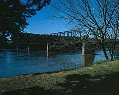
| 7 |
Eisenhower Bridge |
Upload image |
000000001998-05-15-0000May 15, 1998
(#98000478) |
3 miles east of County Road V56
40°40′43″N 92°07′02″W / 40.678611°N 92.117222°W / 40.678611; -92.117222 (Eisenhower Bridge) |
Milton |
|
| 8 |
Hotel Manning |
|
000000001973-04-23-0000April 23, 1973
(#73000740) |
River and Van Buren Sts.
40°43′47″N 91°57′40″W / 40.729722°N 91.961111°W / 40.729722; -91.961111 (Hotel Manning) |
Keosauqua |
|
| 9 |
Kilbourn Bridge |
|
000000001998-05-15-0000May 15, 1998
(#98000477) |
3 miles west of Iowa Highway 1
40°47′56″N 91°58′14″W / 40.798889°N 91.970556°W / 40.798889; -91.970556 (Kilbourn Bridge) |
Kilbourn |
|
| 10 |
Lacey-Keosauqua State Park, Lodge and Picnic Area (Area A) |
Upload image |
000000001990-11-15-0000November 15, 1990
(#90001668) |
Off Iowa Highway 1 on the southern bank of the Des Moines River
40°43′20″N 91°59′39″W / 40.722222°N 91.994167°W / 40.722222; -91.994167 (Lacey-Keosauqua State Park, Lodge and Picnic Area (Area A)) |
Keosauqua |
|
| 11 |
Lacey-Keosauqua State Park, Picnic and Custodial Group (Area B) |
Upload image |
000000001990-11-15-0000November 15, 1990
(#90001669) |
Off Iowa Highway 1 on the southern bank of the Des Moines River
40°42′57″N 91°58′23″W / 40.715833°N 91.973056°W / 40.715833; -91.973056 (Lacey-Keosauqua State Park, Picnic and Custodial Group (Area B)) |
Keosauqua |
|
| 12 |
Lacey-Keosauqua State Park, Bathing Area (Area C) |
Upload image |
000000001990-11-15-0000November 15, 1990
(#90001670) |
Off Iowa Highway 1 on the southern bank of the Des Moines River
40°42′31″N 91°58′14″W / 40.708611°N 91.970556°W / 40.708611; -91.970556 (Lacey-Keosauqua State Park, Bathing Area (Area C)) |
Keosauqua |
|
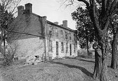
| 13 |
Abner Martin House |
|
000000001984-04-12-0000April 12, 1984
(#84001604) |
South of Mount Zion off Iowa Highway 1
40°46′31″N 91°55′37″W / 40.775385°N 91.927082°W / 40.775385; -91.927082 (Abner Martin House) |
Mount Zion |
|
| 14 |
Meek's Flour Mill |
Upload image |
000000001983-01-27-0000January 27, 1983
(#83000406) |
1st St.
40°41′52″N 91°48′15″W / 40.697778°N 91.804167°W / 40.697778; -91.804167 (Meek's Flour Mill) |
Bonaparte |
|
| 15 |
Midway Stock Farm Barn |
Upload image |
000000001999-02-22-0000February 22, 1999
(#99000126) |
0.3 miles south of the junction of Iowa Highways 1 and 16
40°48′09″N 91°55′50″W / 40.8025°N 91.930556°W / 40.8025; -91.930556 (Midway Stock Farm Barn) |
Keosauqua |
|
| 16 |
Franklin Pearson House |
|
000000001978-05-22-0000May 22, 1978
(#78001267) |
Dodge St.
40°44′08″N 91°58′03″W / 40.735556°N 91.9675°W / 40.735556; -91.9675 (Franklin Pearson House) |
Keosauqua |
|
| 17 |
Voltaire Twombley Building |
|
000000001993-07-29-0000July 29, 1993
(#93000655) |
803 1st St.
40°43′52″N 91°57′40″W / 40.731111°N 91.961111°W / 40.731111; -91.961111 (Voltaire Twombley Building) |
Keosauqua |
|
| 18 |
Van Buren County Courthouse |
|
000000001977-11-09-0000November 9, 1977
(#77000562) |
904 4th St.
40°44′00″N 91°57′48″W / 40.733333°N 91.963333°W / 40.733333; -91.963333 (Van Buren County Courthouse) |
Keosauqua |
|
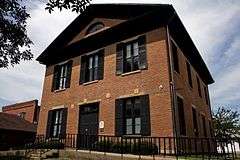
| 19 |
Vernon School |
Upload image |
000000002002-09-12-0000September 12, 2002
(#02001024) |
26849 South St.
40°43′17″N 91°51′23″W / 40.721389°N 91.856389°W / 40.721389; -91.856389 (Vernon School) |
Vernon |
|
| 20 |
Wickfield Round Barn |
Upload image |
000000001986-06-30-0000June 30, 1986
(#86001447) |
Off Iowa Highway 2
40°40′04″N 92°01′23″W / 40.667778°N 92.023056°W / 40.667778; -92.023056 (Wickfield Round Barn) |
Cantril |
|
Another property was once listed on the register, but was removed:
See also
References
- ↑ The latitude and longitude information provided in this table was derived originally from the National Register Information System, which has been found to be fairly accurate for about 99% of listings. For about 1% of NRIS original coordinates, experience has shown that one or both coordinates are typos or otherwise extremely far off; some corrections may have been made. A more subtle problem causes many locations to be off by up to 150 yards, depending on location in the country: most NRIS coordinates were derived from tracing out latitude and longitudes off of USGS topographical quadrant maps created under the North American Datum of 1927, which differs from the current, highly accurate WGS84 GPS system used by most on-line maps. Chicago is about right, but NRIS longitudes in Washington are higher by about 4.5 seconds, and are lower by about 2.0 seconds in Maine. Latitudes differ by about 1.0 second in Florida. Some locations in this table may have been corrected to current GPS standards.
- ↑ "National Register of Historic Places: Weekly List Actions". National Park Service, United States Department of the Interior. Retrieved on December 16, 2016.
- 1 2 Numbers represent an ordering by significant words. Various colorings, defined here, differentiate National Historic Landmarks and historic districts from other NRHP buildings, structures, sites or objects.
- ↑ National Park Service (2008-04-24). "National Register Information System". National Register of Historic Places. National Park Service.
- ↑ The eight-digit number below each date is the number assigned to each location in the National Register Information System database, which can be viewed by clicking the number.
|
|---|
|
| Topics | |
|---|
|
| Lists by states | |
|---|
|
| Lists by insular areas | |
|---|
|
| Lists by associated states | |
|---|
|
| Other areas | |
|---|
|
-
 Portal Portal
-
 WikiProject WikiProject
|