| [3] |
Name on the Register[4] |
Image |
Date listed[5] |
Location |
City or town |
Description |
|---|
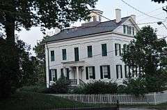
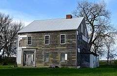
| 1 |
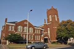
Beers and St. John Company Coach Inn |
|
000000002016-04-05-0000April 5, 2016
(#16000130) |
1193 US 6
41°35′08″N 91°19′45″W / 41.585575°N 91.329279°W / 41.585575; -91.329279 (Beers and St. John Company Coach Inn) |
West Liberty vicinity |
|
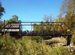
| 2 |
Big Slough Creek Bridge |
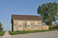
|
000000001998-05-15-0000May 15, 1998
(#98000492) |
Bancroft Ave. over Big Slough Creek
41°28′38″N 91°20′53″W / 41.477222°N 91.348056°W / 41.477222; -91.348056 (Big Slough Creek Bridge) |
Nichols |
|
| 3 |
Bridge near West Liberty |
|
000000001998-05-15-0000May 15, 1998
(#98000491) |
120th St. over an unnamed stream
41°34′06″N 91°19′24″W / 41.568333°N 91.323333°W / 41.568333; -91.323333 (Bridge near West Liberty) |
West Liberty |
|
| 4 |
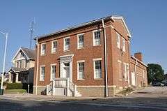
Chicago, Rock Island and Pacific Railroad-Wilton Depot |
|
000000001988-08-25-0000August 25, 1988
(#88001326) |
N. Railroad St.
41°35′16″N 91°00′58″W / 41.5878°N 91.0161°W / 41.5878; -91.0161 (Chicago, Rock Island and Pacific Railroad-Wilton Depot) |
Wilton |
|
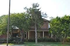
| 5 |
Alexander Clark House |
|
000000001976-10-14-0000October 14, 1976
(#76000796) |
203 W. 3rd St.
41°25′17″N 91°02′53″W / 41.4214°N 91.0481°W / 41.4214; -91.0481 (Alexander Clark House) |
Muscatine |
|
| 6 |
Clark-Blackwell House |
|
000000001983-01-27-0000January 27, 1983
(#83000396) |
206 Cherry St.
41°25′01″N 91°03′12″W / 41.4169°N 91.0533°W / 41.4169; -91.0533 (Clark-Blackwell House) |
Muscatine |
|
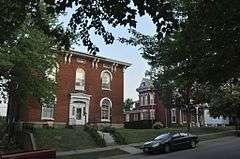
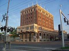
| 7 |
Downtown Commercial Historic District |
|
000000002006-05-24-0000May 24, 2006
(#06000423) |
Roughly nine blocks centered on 2nd St. between Pine and Mulberry
41°25′24″N 91°02′44″W / 41.423333°N 91.045556°W / 41.423333; -91.045556 (Downtown Commercial Historic District) |
Muscatine |
|
| 8 |
Pliny and Adelia Fay House |
|
000000001998-04-23-0000April 23, 1998
(#98000382) |
112 Locust St.
41°25′04″N 91°03′03″W / 41.4178°N 91.0508°W / 41.4178; -91.0508 (Pliny and Adelia Fay House) |
Muscatine |
|
| 9 |
First Presbyterian Church |
|
000000001977-09-14-0000September 14, 1977
(#77000544) |
401 Iowa Ave.
41°25′22″N 91°02′51″W / 41.4228°N 91.0475°W / 41.4228; -91.0475 (First Presbyterian Church) |
Muscatine |
|
| 10 |
W. Joseph Fuller House |
|
000000001982-12-10-0000December 10, 1982
(#82000416) |
1001 Mulberry Ave.
41°25′49″N 91°02′51″W / 41.4303°N 91.0475°W / 41.4303; -91.0475 (W. Joseph Fuller House) |
Muscatine |
|
| 11 |
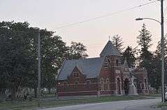
Greenwood Cemetery Chapel |
|
000000002001-09-21-0000September 21, 2001
(#01001013) |
1814 Lucas
41°25′12″N 91°03′50″W / 41.42°N 91.0639°W / 41.42; -91.0639 (Greenwood Cemetery Chapel) |
Muscatine |
|
| 12 |
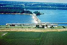
Lock and Dam No. 16 Historic District |
|
000000002004-03-10-0000March 10, 2004
(#04000176) |
33109 102nd Ave., W.
41°25′46″N 91°00′42″W / 41.429327°N 91.011721°W / 41.429327; -91.011721 (Lock and Dam No. 16 Historic District) |
Muscatine |
|
| 13 |
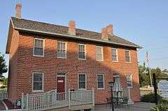
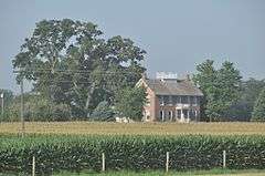
S. M. McKibben House |
|
000000001974-08-27-0000August 27, 1974
(#74000800) |
Walnut St. between Front and 2nd
41°25′21″N 91°02′32″W / 41.4225°N 91.0422°W / 41.4225; -91.0422 (S. M. McKibben House) |
Muscatine |
Now houses the local chamber of commerce
|
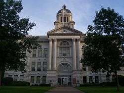
| 14 |
Muscatine County Courthouse |
|
000000001981-07-02-0000July 2, 1981
(#81000260) |
3rd St.
41°25′28″N 91°02′35″W / 41.424444°N 91.043056°W / 41.424444; -91.043056 (Muscatine County Courthouse) |
Muscatine |
|
| 15 |
Samuel Nichols House |
|
000000001978-03-31-0000March 31, 1978
(#78001247) |
East of Nichols off Iowa Highway 22
41°28′43″N 91°16′58″W / 41.4786°N 91.2828°W / 41.4786; -91.2828 (Samuel Nichols House) |
Nichols |
|
| 16 |
Old Jail |
|
000000001974-07-24-0000July 24, 1974
(#74000801) |
411 E. 4th St.
41°25′49″N 91°02′37″W / 41.4303°N 91.0436°W / 41.4303; -91.0436 (Old Jail) |
Muscatine |
|
| 17 |
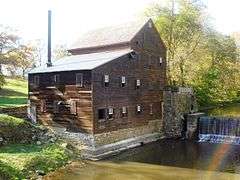
Pine Creek Gristmill |
|
000000001979-12-10-0000December 10, 1979
(#79000919) |
Northeast of Muscatine in Wildcat Den State Park
41°28′03″N 90°52′03″W / 41.4675°N 90.8675°W / 41.4675; -90.8675 (Pine Creek Gristmill) |
Muscatine |
|
| 18 |
Pine Mill Bridge |
|
000000001998-05-15-0000May 15, 1998
(#98000493) |
Over Pine Creek in Wildcat Den State Park
41°28′03″N 90°52′02″W / 41.4675°N 90.867222°W / 41.4675; -90.867222 (Pine Mill Bridge) |
Muscatine |
|
| 19 |
Pine Mills German Methodist Episcopal Church |
|
000000002003-10-17-0000October 17, 2003
(#03001051) |
180th St. and Verde Ave.
41°28′50″N 90°52′51″W / 41.4806°N 90.8808°W / 41.4806; -90.8808 (Pine Mills German Methodist Episcopal Church) |
Muscatine |
|
| 20 |
Sinnett Octagon House |
|
000000001974-07-18-0000July 18, 1974
(#74000802) |
North of Muscatine near Iowa Highway 38
41°27′11″N 91°01′50″W / 41.4531°N 91.0306°W / 41.4531; -91.0306 (Sinnett Octagon House) |
Muscatine |
|
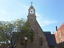
| 21 |
Trinity Episcopal Church |
|
000000001974-10-29-0000October 29, 1974
(#74000803) |
411 E. 2nd St.
41°25′25″N 91°02′31″W / 41.4236°N 91.0419°W / 41.4236; -91.0419 (Trinity Episcopal Church) |
Muscatine |
|
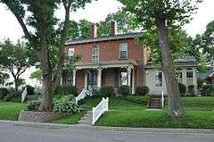
| 22 |
George H. and Loretta Ward House |
|
000000001997-05-02-0000May 2, 1997
(#97000388) |
719 N. Calhoun St.
41°34′31″N 91°15′49″W / 41.575278°N 91.263611°W / 41.575278; -91.263611 (George H. and Loretta Ward House) |
West Liberty |
|
| 23 |
J. C. B. Warde House |
|
000000001979-04-26-0000April 26, 1979
(#79000920) |
205 Cherry St.
41°25′02″N 91°03′09″W / 41.4172°N 91.0525°W / 41.4172; -91.0525 (J. C. B. Warde House) |
Muscatine |
|
| 24 |
Welch Apartments |
|
000000001979-01-15-0000January 15, 1979
(#79000921) |
224 Iowa Ave.
41°25′18″N 91°02′47″W / 41.4217°N 91.0464°W / 41.4217; -91.0464 (Welch Apartments) |
Muscatine |
|
| 25 |
West Hill Historic District |
|
000000002008-04-30-0000April 30, 2008
(#08000356) |
Roughly bounded by W. 2nd St. from Pine to Ash, W. 3rd St., and W. 4th St. from Chestnut to near Ash.
41°25′10″N 91°03′03″W / 41.4195°N 91.05095°W / 41.4195; -91.05095 (West Hill Historic District) |
Muscatine |
|
| 26 |
West Liberty Commercial Historic District |
|
000000002002-09-12-0000September 12, 2002
(#02001035) |
Bounded by 4th St., railroad tracks, and Clay and Spencer Sts.
40°34′16″N 91°15′48″W / 40.571111°N 91.263333°W / 40.571111; -91.263333 (West Liberty Commercial Historic District) |
West Liberty |
|
| 27 |
West Liberty Fairgrounds Historic District |
|
000000002015-12-22-0000December 22, 2015
(#15000916) |
101 N. Clay St.
41°34′03″N 91°15′56″W / 41.567455°N 91.265539°W / 41.567455; -91.265539 (West Liberty Fairgrounds Historic District) |
West Liberty |
|
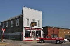
| 28 |
Wilton Candy Kitchen |
|
000000001993-01-07-0000January 7, 1993
(#92001742) |
310 Cedar St.
41°35′16″N 91°01′06″W / 41.5878°N 91.0183°W / 41.5878; -91.0183 (Wilton Candy Kitchen) |
Wilton |
|
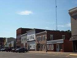
| 29 |
Wilton Commercial Historic District |
|
000000002016-09-12-0000September 12, 2016
(#16000606) |
Roughly bounded by 4th, E. & W. Cedar, Railroad E. & W. & Chestnut Sts.
41°35′19″N 91°01′01″W / 41.588749°N 91.016964°W / 41.588749; -91.016964 (Wilton Commercial Historic District) |
Wilton |
|


_from_SE_3.JPG)