| [3] |
Name on the Register[4] |
Image |
Date listed[5] |
Location |
City or town |
Description |
|---|
|
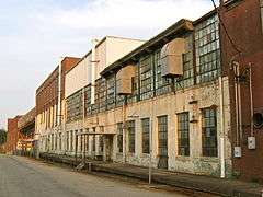
American Spinning Company Mill No. 2,
300 Hammett St.,
Greenville vicinity, 16000730,
LISTED, 10/18/16
|
| 1 |
American Spinning Company Mill No. 2 |
Upload image |
000000002016-10-18-0000October 18, 2016
(#16000730) |
300 Hammett St.
34°52′24″N 82°24′44″W / 34.873339°N 82.412309°W / 34.873339; -82.412309 (American Spinning Company Mill No. 2) |
Greenville vicinity |
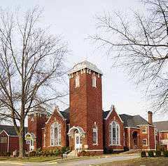
|
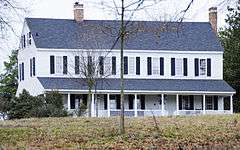
| 2 |
Arthur Barnwell House |
|
000000001982-03-19-0000March 19, 1982
(#82003867) |
South of Greer on South Carolina Highway 14
34°51′18″N 82°13′41″W / 34.855°N 82.228056°W / 34.855; -82.228056 (Arthur Barnwell House) |
Greer |
|
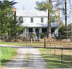
| 3 |
William Bates House |
|
000000001978-12-04-0000December 4, 1978
(#78002512) |
East of Greenville on South Carolina Highway 14
34°50′53″N 82°14′04″W / 34.848056°N 82.234444°W / 34.848056; -82.234444 (William Bates House) |
Greenville |
|
| 4 |
Brandon Mill |
|
000000002014-09-03-0000September 3, 2014
(#14000317) |
25 Draper St.
34°50′39″N 82°25′53″W / 34.8443°N 82.4314°W / 34.8443; -82.4314 (Brandon Mill) |
Greenville vicinity |
|
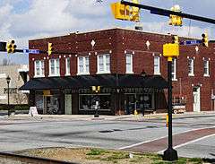
| 5 |
Burdette Building |
|
000000002003-07-17-0000July 17, 2003
(#03000660) |
104 E. Curtis St.
34°44′14″N 82°15′19″W / 34.737222°N 82.255278°W / 34.737222; -82.255278 (Burdette Building) |
Simpsonville |
|
| 6 |
Campbell's Covered Bridge |
|
000000002009-07-01-0000July 1, 2009
(#09000483) |
123 Campbell Covered Bridge Rd.
35°05′09″N 82°15′51″W / 35.0858°N 82.2642°W / 35.0858; -82.2642 (Campbell's Covered Bridge) |
Gowensville |
|
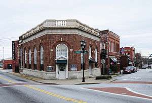
| 7 |
Cannon Building |
|
000000002005-09-28-0000September 28, 2005
(#05001100) |
100 N. Main St.
34°41′37″N 82°11′59″W / 34.693611°N 82.199722°W / 34.693611; -82.199722 (Cannon Building) |
Fountain Inn |
|
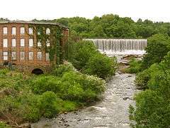
| 8 |
Conestee Mill |
|
000000002014-03-02-0000March 2, 2014
(#09000913) |
1 Spanco Dr.
34°46′13″N 82°20′51″W / 34.770304°N 82.347627°W / 34.770304; -82.347627 (Conestee Mill) |
Conestee |
|
| 9 |
Cureton-Huff House |
|
000000001983-01-13-0000January 13, 1983
(#83002196) |
Southwest of Simpsonville off S-272 (West Georgia Road)
34°41′34″N 82°20′02″W / 34.692778°N 82.333889°W / 34.692778; -82.333889 (Cureton-Huff House) |
Simpsonville |
|
| 10 |
Davenport House |
|
000000001999-02-01-0000February 1, 1999
(#98001623) |
100 Randall St.
34°56′10″N 82°13′37″W / 34.936111°N 82.226944°W / 34.936111; -82.226944 (Davenport House) |
Greer |
|
| 11 |
Fairview Presbyterian Church |
|
000000001977-08-16-0000August 16, 1977
(#77001224) |
West of Fountain Inn off South Carolina Highway 418
34°38′37″N 82°15′05″W / 34.643611°N 82.251389°W / 34.643611; -82.251389 (Fairview Presbyterian Church) |
Fountain Inn |
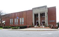
|
| 12 |
Fountain Inn High School |
|
000000002009-06-03-0000June 3, 2009
(#09000390) |
315 N. Main St.
34°41′44″N 82°12′06″W / 34.695508°N 82.201642°W / 34.695508; -82.201642 (Fountain Inn High School) |
Fountain Inn |
|
| 13 |
Fountain Inn Principal's House and Teacherage |
|
000000002011-06-27-0000June 27, 2011
(#11000415) |
105 Mt. Zion Dr.
34°41′47″N 82°11′33″W / 34.696389°N 82.1925°W / 34.696389; -82.1925 (Fountain Inn Principal's House and Teacherage) |
Fountain Inn |
|
| 14 |
James A. Fulmer House |
Upload image |
000000002015-10-05-0000October 5, 2015
(#15000706) |
303 N. Main St.
34°41′45″N 82°12′06″W / 34.6957°N 82.2017°W / 34.6957; -82.2017 (James A. Fulmer House) |
Fountain Inn |
|
| 15 |
Gilreath's Mill |
|
000000001976-05-28-0000May 28, 1976
(#76001703) |
4 miles northwest of Greer on South Carolina Highway 101
34°58′23″N 82°16′44″W / 34.973056°N 82.278889°W / 34.973056; -82.278889 (Gilreath's Mill) |
Greer |
|
| 16 |
John H. Goodwin House |
|
000000001983-09-08-0000September 8, 1983
(#83002197) |
South Carolina Highway 11 at U.S. Route 25
35°05′19″N 82°27′08″W / 35.088611°N 82.452222°W / 35.088611; -82.452222 (John H. Goodwin House) |
Travelers Rest |
|
| 17 |
Greer Depot |
|
000000001987-03-06-0000March 6, 1987
(#87000409) |
311 Trade St.
34°56′10″N 82°13′33″W / 34.936111°N 82.225833°W / 34.936111; -82.225833 (Greer Depot) |
Greer |
|
| 18 |
Greer Downtown Historic District |
|
000000001997-09-18-0000September 18, 1997
(#97001156) |
Roughly bounded by Trade, E. Poinsett, Randall, Victoria, and N. Main Sts.
34°56′16″N 82°13′43″W / 34.937778°N 82.228611°W / 34.937778; -82.228611 (Greer Downtown Historic District) |
Greer |
|
| 19 |
Greer Post Office |
|
000000002011-01-31-0000January 31, 2011
(#10001184) |
106 S Main St.
34°56′19″N 82°13′38″W / 34.938528°N 82.227111°W / 34.938528; -82.227111 (Greer Post Office) |
Greer |
|
| 20 |
Hopkins Farm |
|
000000002007-09-20-0000September 20, 2007
(#07000987) |
3717 Fork Shoals Rd.
34°38′53″N 82°18′30″W / 34.648069°N 82.308228°W / 34.648069; -82.308228 (Hopkins Farm) |
Simpsonville |
|
| 21 |
Louie James House |
|
000000001996-09-19-0000September 19, 1996
(#96000985) |
401 W. Poinsett St.
34°56′25″N 82°14′05″W / 34.940278°N 82.234722°W / 34.940278; -82.234722 (Louie James House) |
Greer |
|
| 22 |
McBee Methodist Church |
|
000000001972-03-23-0000March 23, 1972
(#72001212) |
Main St.
34°46′00″N 82°21′10″W / 34.766667°N 82.352778°W / 34.766667; -82.352778 (McBee Methodist Church) |
Conestee |
|
| 23 |
McDowell House |
|
000000002010-11-17-0000November 17, 2010
(#10000921) |
500 N Main St.
34°41′53″N 82°12′17″W / 34.698056°N 82.204722°W / 34.698056; -82.204722 (McDowell House) |
Fountain Inn |
|
| 24 |
Monaghan Mill |
|
000000002005-10-04-0000October 4, 2005
(#05001159) |
201 Smythe St.
34°52′00″N 82°25′27″W / 34.866667°N 82.424167°W / 34.866667; -82.424167 (Monaghan Mill) |
City View |
|
| 25 |
Paris Mountain State Park Historic District |
|
000000001998-04-30-0000April 30, 1998
(#98000416) |
2401 State Park Rd.
34°56′25″N 82°23′39″W / 34.940278°N 82.394167°W / 34.940278; -82.394167 (Paris Mountain State Park Historic District) |
Greenville |
|
| 26 |
Pelham Mills Site |
|
000000001987-11-19-0000November 19, 1987
(#87001954) |
South of Greer on South Carolina Highway 14
34°51′25″N 82°13′36″W / 34.857073°N 82.226637°W / 34.857073; -82.226637 (Pelham Mills Site) |
Pelham |
|
| 27 |
Poinsett Bridge |
|
000000001970-10-22-0000October 22, 1970
(#70000590) |
About 4 miles north of Tigerville on County Road 42
35°07′47″N 82°23′06″W / 35.129722°N 82.385°W / 35.129722; -82.385 (Poinsett Bridge) |
Tigerville |
|
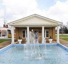
| 28 |
Robert Quillen Office and Library |
|
000000002012-01-30-0000January 30, 2012
(#10000316) |
200 N. Main St.
34°41′40″N 82°12′01″W / 34.694388°N 82.200201°W / 34.694388; -82.200201 (Robert Quillen Office and Library) |
Fountain Inn |
|
| 29 |
George Salmon House |
|
000000001988-01-21-0000January 21, 1988
(#87002520) |
South Carolina Highway 414, 1.8 miles west of U.S. Route 25
35°02′07″N 82°27′31″W / 35.035278°N 82.458611°W / 35.035278; -82.458611 (George Salmon House) |
Travelers Rest |
|
| 30 |
Simpsonville Baptist Church |
|
000000001992-10-13-0000October 13, 1992
(#92001309) |
106 Church St.
34°44′21″N 82°15′10″W / 34.739167°N 82.252778°W / 34.739167; -82.252778 (Simpsonville Baptist Church) |
Simpsonville |
|
| 31 |
Southern Bleachery and Print Works |
|
000000002012-07-25-0000July 25, 2012
(#12000439) |
113 Mill St.
34°55′12″N 82°17′21″W / 34.92005°N 82.28928°W / 34.92005; -82.28928 (Southern Bleachery and Print Works) |
Taylors |
|
| 32 |
Earle R. Taylor House and Peach Packing Shed |
|
000000002012-06-27-0000June 27, 2012
(#12000372) |
1001 Locust Hill Rd.
34°56′52″N 82°15′46″W / 34.947853°N 82.26273°W / 34.947853; -82.26273 (Earle R. Taylor House and Peach Packing Shed) |
Greer vicinity |
|
| 33 |
Tullyton |
|
000000001990-07-31-0000July 31, 1990
(#89002151) |
606 Hickory Tavern Rd.
34°36′24″N 82°13′57″W / 34.606667°N 82.2325°W / 34.606667; -82.2325 (Tullyton) |
Fountain Inn |
|
| 34 |
R. Perry Turner House |
|
000000001999-02-01-0000February 1, 1999
(#98001624) |
211 N. Main St.
34°56′29″N 82°13′31″W / 34.941389°N 82.225278°W / 34.941389; -82.225278 (R. Perry Turner House) |
Greer |
|
| 35 |
Robert G. Turner House |
|
000000001999-02-01-0000February 1, 1999
(#98001625) |
305 N. Main St.
34°56′34″N 82°13′30″W / 34.942778°N 82.225°W / 34.942778; -82.225 (Robert G. Turner House) |
Greer |
|
| 36 |
F. W. Welborn House |
|
000000002010-11-23-0000November 23, 2010
(#10000920) |
405 N. Weston St.
34°41′51″N 82°12′09″W / 34.6975°N 82.2025°W / 34.6975; -82.2025 (F. W. Welborn House) |
Fountain Inn |
|
| 37 |
Woodside Cotton Mill Village Historic District |
|
000000001987-04-30-0000April 30, 1987
(#87000678) |
Woodside Ave. and E. Main St.
34°51′12″N 82°25′47″W / 34.853333°N 82.429722°W / 34.853333; -82.429722 (Woodside Cotton Mill Village Historic District) |
Woodside |
|

.jpg)

.jpg)


.jpg)


.JPG)
.jpg)
.jpg)


.jpg)