National Register of Historic Places listings in Emery County, Utah
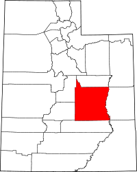
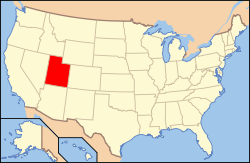
Location of Emery County in Utah
This is a list of the National Register of Historic Places listings in Emery County, Utah.
This is intended to be a complete list of the properties and districts on the National Register of Historic Places in Emery County, Utah, United States. Latitude and longitude coordinates are provided for many National Register properties and districts; these locations may be seen together in a map.[1]
There are 21 properties and districts listed on the National Register in the county, including 1 National Historic Landmark.
- This National Park Service list is complete through NPS recent listings posted December 2, 2016.[2]
Current listings
| [3] | Name on the Register[4] | Image | Date listed[5] | Location | City or town | Description |
|---|---|---|---|---|---|---|
| 1 | Black Dragon Canyon Pictographs | Upload image | (#80003905) |
Address Restricted |
Green River | |
| 2 | Buckhorn Wash Rock Art Sites |  |
(#80003898) |
Address Restricted |
Castle Dale | |
| 3 | Castle Dale High School Shop |  |
(#85000804) |
300 N. Center St. 39°12′59″N 111°01′13″W / 39.216389°N 111.020278°W |
Castle Dale | |
| 4 | Castle Dale School |  |
(#78002657) |
65 E. 100 North 39°12′51″N 111°01′02″W / 39.214167°N 111.017222°W |
Castle Dale | Now houses the Castle Dale City Hall and the Emery County Pioneer Museum |
| 5 | Paul C. Christensen House |  |
(#80003899) |
15 E. 100 North 39°12′50″N 111°01′07″W / 39.213889°N 111.018611°W |
Castle Dale | |
| 6 | Denver and Rio Grande Lime Kiln |  |
(#80003901) |
Southeast of Cleveland, along County Rd. 335 south of Cedar Mountain 39°11′16″N 110°42′09″W / 39.187847°N 110.702569°W |
Cleveland | |
| 7 | Desolation Canyon | |
(#68000057) |
Along the Green River in northeastern Emery County between Ouray and Green River[6] 39°30′01″N 110°01′19″W / 39.500278°N 110.021944°W |
Green River | Split between Emery, Grand, Carbon, and Uintah counties |
| 8 | Emery LDS Church |  |
(#80003903) |
Off State Route 10 38°55′27″N 111°14′48″W / 38.924167°N 111.246667°W |
Emery | |
| 9 | Ferron Box Pictographs and Petroglyphs |  |
(#80003904) |
Address Restricted |
Ferron | |
| 10 | Ferron Presbyterian Church and Cottage |  |
(#78002658) |
Mill Rd. and 3rd West 39°05′36″N 111°08′28″W / 39.093333°N 111.141111°W |
Ferron | |
| 11 | Green River Presbyterian Church |  |
(#88002998) |
134 W. 3rd Ave. 38°59′45″N 110°09′54″W / 38.995833°N 110.165°W |
Green River | |
| 12 | Huntington Roller Mill and Miller's House |  |
(#79002495) |
400 North and 550 West Sts. 39°20′02″N 110°58′36″W / 39.333889°N 110.976667°W |
Huntington | |
| 13 | Huntington Tithing Granary |  |
(#85000261) |
45 W. 300 North, rear 39°19′53″N 110°57′55″W / 39.331389°N 110.965278°W |
Huntington | |
| 14 | Peter Johansen House |  |
(#80003900) |
830 N. Center St. 39°13′35″N 111°01′07″W / 39.226389°N 111.018611°W |
Castle Dale | |
| 15 | Lars Peter Larson House |  |
(#80003902) |
210 E. 100 South 39°20′49″N 110°50′49″W / 39.346944°N 110.846944°W |
Cleveland | |
| 16 | Leander Lemmon House |  |
(#02001040) |
45 W. Center St. 39°19′34″N 110°57′54″W / 39.326111°N 110.965°W |
Huntington | |
| 17 | Rochester-Muddy Creek Petroglyph Site | 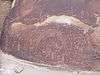 |
(#75001803) |
Address Restricted |
Emery | |
| 18 | San Rafael Bridge |  |
(#96000617) |
County Road 3-32 over the San Rafael River, approximately 23 miles (37 km) southeast of Castle Dale 39°04′52″N 110°39′49″W / 39.081111°N 110.663611°W |
Castle Dale | |
| 19 | Justus Wellington Seeley II House |  |
(#79002493) |
Center and 100 South Sts. 39°12′40″N 111°01′06″W / 39.211111°N 111.018333°W |
Castle Dale | |
| 20 | Samuel Singleton House | 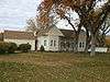 |
(#79002494) |
South of Ferron on State Route 10 39°05′02″N 111°07′57″W / 39.083889°N 111.1325°W |
Ferron | |
| 21 | Temple Mountain Wash Pictographs | 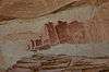 |
(#76001814) |
Address Restricted |
Hanksville |
See also
References
- ↑ The latitude and longitude information provided in this table was derived originally from the National Register Information System, which has been found to be fairly accurate for about 99% of listings. For about 1% of NRIS original coordinates, experience has shown that one or both coordinates are typos or otherwise extremely far off; some corrections may have been made. A more subtle problem causes many locations to be off by up to 150 yards, depending on location in the country: most NRIS coordinates were derived from tracing out latitude and longitudes off of USGS topographical quadrant maps created under the North American Datum of 1927, which differs from the current, highly accurate WGS84 GPS system used by most on-line maps. Chicago is about right, but NRIS longitudes in Washington are higher by about 4.5 seconds, and are lower by about 2.0 seconds in Maine. Latitudes differ by about 1.0 second in Florida. Some locations in this table may have been corrected to current GPS standards.
- ↑ "National Register of Historic Places: Weekly List Actions". National Park Service, United States Department of the Interior. Retrieved on December 2, 2016.
- ↑ Numbers represent an ordering by significant words. Various colorings, defined here, differentiate National Historic Landmarks and historic districts from other NRHP buildings, structures, sites or objects.
- ↑ National Park Service (2008-04-24). "National Register Information System". National Register of Historic Places. National Park Service.
- ↑ The eight-digit number below each date is the number assigned to each location in the National Register Information System database, which can be viewed by clicking the number.
- ↑ Location and coordinates derived from its GNIS entry; the NRIS lists the site as "Address unknown"
External links
![]() Media related to National Register of Historic Places in Emery County, Utah at Wikimedia Commons
Media related to National Register of Historic Places in Emery County, Utah at Wikimedia Commons
 |  | ||
| Topics | |
|---|---|
| Lists by states |
|
| Lists by insular areas | |
| Lists by associated states | |
| Other areas | |
| |
Municipalities and communities of Emery County, Utah, United States | ||
|---|---|---|
| Cities | | |
| Towns | ||
| Unincorporated communities | ||
| Indian reservation | ||
| Ghost towns | ||
| Footnotes | ‡This populated place also has portions in an adjacent county or counties | |
This article is issued from Wikipedia - version of the 11/22/2016. The text is available under the Creative Commons Attribution/Share Alike but additional terms may apply for the media files.