Mundaú Lagoon
| Mundaú Lagoon Lagoa Mundaú | |
|---|---|
 Mundaú Lagoon | |
| Location | Santa Luzia do Norte, Coqueiro Seco, Alagoas |
| Coordinates | 9°37′59″S 35°46′59″W / 9.633°S 35.783°WCoordinates: 9°37′59″S 35°46′59″W / 9.633°S 35.783°W |
| Lake type | estuarine lagoon |
| Primary inflows | Paraíba do Meio River |
| Primary outflows | Atlantic Ocean |
| Basin countries | Brazil |
| Surface area | 23 square kilometres (8.9 sq mi) |
| Average depth | 2 metres (6 ft 7 in) |
| Max. depth | 4 metres (13 ft) |
| Surface elevation | 0 m (0 ft) |
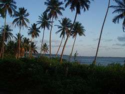
Mundaú Lagoon is an estuarine lagoon situated west of Maceió, capital city of Alagoas state, in Brazil. Its total area is 23 km². The lake receives the Mundaú River, and is connected to the Atlantic Ocean and Manguaba Lagoon by a network of canals which cross the plain forming a lot of little islands. The large mangrove and the numerous kind of fish, crabs, shrimps and shellfish are its remarkable characteristics. Mundaú Lagoon is the northernmost of several coastal lakes with the same features, including Manguaba, Roteiro and Jequiá lagoons.
Besides Maceió, two other municipalities are located on its edge, the little towns of Santa Luzia do Norte and Coqueiro Seco.
Despite its astonishing natural beauty, the Mundaú Lagoon suffers with pollution problems, mainly due to urban sewage dispensing along its shore close to downtown Maceió. This compromises the communities who makes a living from the fishing on the lagoon. Unfortunately, this is not the only pollution problem surrounding Maceió. The Riacho Salgadinho is also the destination for most of the sewage system in Maceió downtown. In the past years, several politicians have made promises of putting sewage treatment stations to alleviate the problems caused by the pollution during the rainy season, but virtually no progress has been made.