Mount Lamborn
| Mount Lamborn | |
|---|---|
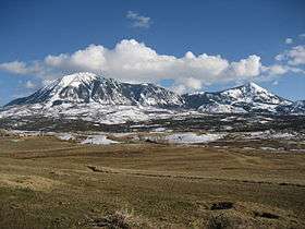 View of Mount Lamborn (left) and Landsend Peak (right) from Lamborn Mesa, near Paonia, Colorado | |
| Highest point | |
| Elevation | 11,402 ft (3,475 m) [1][2] |
| Prominence | 1,616 ft (493 m) [3] |
| Isolation | 2.39 mi (3.85 km) [3] |
| Listing | Colorado county high points 40th |
| Coordinates | 38°48′10″N 107°31′22″W / 38.8029015°N 107.5228458°WCoordinates: 38°48′10″N 107°31′22″W / 38.8029015°N 107.5228458°W [1] |
| Geography | |
 Mount Lamborn | |
| Location | High point of Delta County, Colorado, United States[3] |
| Parent range | West Elk Mountains[3] |
| Topo map |
USGS 7.5' topographic map Paonia, Colorado[4] |
Mount Lamborn is a mountain summit in the West Elk Mountains range of the Rocky Mountains of North America. The 11,402-foot (3,475 m) peak is located in Gunnison National Forest, 5.9 miles (9.5 km) southeast by south (bearing 141°) of the Town of Paonia in Delta County, Colorado, United States. The summit of Mount Lamborn is the highest point in Delta County.[1][2][3][4] Together with nearby Landsend Peak to the southwest, it lies at the western edge of the West Elks, rising dramatically nearly 6,000 ft (1,800 m) above the valley of the North Fork Gunnison River to the west.
Mountain
See also
References
- 1 2 3 "LAMBORN". NGS data sheet. U.S. National Geodetic Survey. Retrieved October 20, 2014.
- 1 2 The elevation of Mount Lamborn includes an adjustment of +1.648 m (+5.41 ft) from NGVD 29 to NAVD 88.
- 1 2 3 4 5 "Mount Lamborn, Colorado". Peakbagger.com. Retrieved October 20, 2014.
- 1 2 "Mount Lamborn". Geographic Names Information System. United States Geological Survey. Retrieved November 15, 2014.
External links

This article is issued from Wikipedia - version of the 1/16/2016. The text is available under the Creative Commons Attribution/Share Alike but additional terms may apply for the media files.