Moonbeam, Ontario
| Moonbeam | |
|---|---|
| Township (single-tier) | |
| Township of Moonbeam Canton de Moonbeam | |
|
Novelty UFO and visitor centre in Moonbeam | |
 Moonbeam | |
| Coordinates: 49°21′N 82°09′W / 49.350°N 82.150°WCoordinates: 49°21′N 82°09′W / 49.350°N 82.150°W | |
| Country |
|
| Province |
|
| District | Cochrane |
| Settled | 1912 |
| Incorporated | 1922 |
| Government | |
| • Type | Township |
| • Mayor | Gilles Audet |
| • Federal riding | Algoma—Manitoulin—Kapuskasing |
| • Prov. riding | Timmins—James Bay |
| Area[1] | |
| • Land | 235.65 km2 (90.98 sq mi) |
| Population (2011)[1] | |
| • Total | 1,101 |
| • Density | 4.7/km2 (12/sq mi) |
| Time zone | EST (UTC-5) |
| • Summer (DST) | EDT (UTC-4) |
| Postal Code | P0L 1V0 |
| Area code(s) | 705 |
| Website | www.moonbeam.ca |
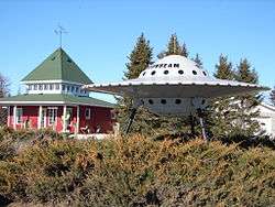
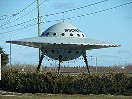
Moonbeam is a township in Ontario, Canada, located in Cochrane District. It is located between the communities of Fauquier and Kitigan along Ontario Highway 11, south of René Brunelle Provincial Park. It is known for its roadside flying saucer, which is also featured prominently in promotional material. The town is most famously referenced in the song "Fly" by the Canadian rock band The Tragically Hip off of their 2006 album World Container.
Origin of the name Moonbeam
The name "Moonbeam" is attributed to early pioneers who allegedly witnessed flashing lights falling from the sky, which they called "moonbeams". These lights fell down or reflected in a creek that flows west from Strickland to Rémi Lake and was called Moonbeam Creek. These lights could have been Northern Lights that often appear with the moon light.[2]
Another suggestion is that the name came from the passengers on the Transcontinental Railway, who would be traveling for many miles through dark forests and when they came to the natural clearing near Moonbeam would be struck by the brilliance of the moon-lit snow. Nevertheless, there is no documented proof of the exact source of this name.[2]
Rémi Lake was named after a Great Trunk Pacific Railway worker who drowned there in 1905.
History
The National Transcontinental Railway, connecting Quebec City with the Canadian Prairies, was completed by 1912 and provided new access to agricultural land and natural resources of northern Ontario. This attracted colonizers from Montreal, Sainte-Agathe-des-Monts, and Saint-Jovite, to the Moonbeam area, looking for land to cultivate or mine.[2]
Timeline:
- The first family to get established in Moonbeam is Théodule and Valentine Léonard in 1909.
- The first baby born in Moonbeam was Marie Régina Lecuyer in 1914.
- The priest, founder of Moonbeam, was Ovila François Paquette O.M.I. in 1916.
- The first school to open its doors was in September 1919.
- The first church to be built in Moonbeam was in 1919-1920, called Nativité de Moonbeam.
- The first cottage to be built on the Rémi Lake is the cottage of a rich tourist from Rochester New-York, Mr. Buelle in 1920.
- The first Reeve of Moonbeam was Joseph Girouard in 1922.
- The first St-Jean Parade was in 1922.
- The incorporation of the District of Fauquier was January 9, 1922.
- The first doctor in the region was Doctor Nicole in Fauquier in 1924.
- The first airplane in Moonbeam was a Curtiss HS-2L flown by Captain C.A. Schiller in 1925.
- The first butter-production firm was open in 1927. It cost $3689.00 to build and $5954.00 for all the machineries.
- The first doctor to open its doors in Moonbeam was Doctor Soucie in 1934.
- 1930-1940, the speed limit was raised to 15 miles per hour.
- 1930-1940, all stores were restricted to not sell tobacco to kids less than 18 years of age.
- The chapel at Rémi Lake celebrated its first mass in 1960.
- The sewage system in the village was installed November 1, 1965.
List of mayors
Mayors from incorporation in 1922 to present:[3]
- Joseph Girouard (1922–1923)
- Célestin Desgroseillers (1924–1928)
- Vital Filion (1929–1931)
- Cléophas Desgroseillers (1932–1935)
- Albert Gaudreault (1936–1938)
- Guillaume Soucie (1939–1942)
- Ernest Léonard (1943–1946)
- Alexandre Lacroix (1947–1950)
- Jos. Aimable Turcotte (1951 and 1955–1958)
- Francis St-Aubin (1952–1954)
- Stanislas Lavoie (1959–1972)
- Raymond Bouchard (1972–1978)
- Gaëtan Filion (1979–1985)
- Olivain Fullum (1985–1997)
- Claude D'Amours (1997–2000)
- Gilles Audet (2000–present)
Demographics
| Canada census – Moonbeam, Ontario community profile | |||
|---|---|---|---|
| 2011 | 2006 | 2001 | |
| Population: | 1101 (-15.2% from 2006) | 1298 (8.1% from 2001) | 1201 (-9.2% from 1996) |
| Land area: | 235.65 km2 (90.98 sq mi) | 235.17 km2 (90.80 sq mi) | 235.17 km2 (90.80 sq mi) |
| Population density: | 4.7/km2 (12/sq mi) | 5.5/km2 (14/sq mi) | 5.1/km2 (13/sq mi) |
| Median age: | 46.9 (M: 47.5, F: 46.3) | 41.2 (M: 41.5, F: 40.7) | |
| Total private dwellings: | 843 | 907 | 979 |
| Median household income: | $55,093 | $48,747 | |
| References: 2011[1] 2006[4] 2001[5] | |||
Population:[6]
- Population in 2006: 1298
- Population in 2001: 1201
- Population in 1996: 1322
- Population in 1991: 1330
Mother tongue:[4]
- English as first language: 12.9%
- French as first language: 83.6%
- English and French as first language: 1.5%
- Other as first language: 2.0%
See also
References
- 1 2 3 "Moonbeam census profile". 2011 Census of Population. Statistics Canada. Retrieved 2012-02-21.
- 1 2 3 Jean Lagacé (2009-11-10). "Did you know?". Corporation of the Township of Moonbeam. Retrieved 2009-12-18.
- ↑ "Moonbeam Mayors". Corporation of the Township of Moonbeam. 2009-11-10. Retrieved 2009-12-18.
- 1 2 "2006 Community Profiles". Canada 2006 Census. Statistics Canada. March 30, 2011. Retrieved 2012-02-21.
- ↑ "2001 Community Profiles". Canada 2001 Census. Statistics Canada. February 17, 2012. Retrieved 2012-02-21.
- ↑ Statistics Canada: 1996, 2001, 2006 census
External links
 |
Unorganized North Cochrane | | ||
| Unorganized North Cochrane | |
Fauquier-Strickland | ||
| ||||
| | ||||
| Unorganized North Cochrane |
| City |  | |
|---|---|---|
| Towns | ||
| Townships | ||
| First Nations | ||
| Indian reserves | ||
| Indian settlements | ||
| Unorganized territories | ||
| Local services boards | ||
| ||