Mayfair

Coordinates: 51°30′32″N 0°08′51″W / 51.508755°N 0.14743°W
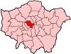
Mayfair is an expensive area in the West End of London towards the east edge of Hyde Park, in the City of Westminster. The district is mainly commercial, with many former homes converted into offices for major corporate headquarters, embassies, as well as hedge funds and real estate businesses. There remains a substantial quantity of residential property as well as some upmarket shops and restaurants, as well as London's largest concentration of five star hotels. Rents are among the highest in London and the world and its prestigious status has been commemorated by being the most expensive property square on the London Monopoly board.
Mayfair is named after the annual fortnight-long "May Fair" that, from 1686 to 1764, took place on the site that is now Shepherd Market.
History
Mayfair was mainly open fields until development started in the Shepherd Market area around 1686 to accommodate the May Fair that had moved from Haymarket in St James's. There were some buildings before 1686 – a cottage in Stanhope Row, dating from 1618, which was destroyed in the Blitz in late 1940,[1] though there is no evidence of meaningful habitation or building before 1686. There has been speculation that the Romans settled in the area before establishing Londinium.[2] A theory has been proposed since the 1950s that Aulus Plautius set up a fort near the junction of Park Street and Oxford Street during the Roman conquest of Britain in AD 43 while waiting for Claudius;[3] the theory was more fully developed in 1993, with a proposal that around the fort a Roman town formed, which was later abandoned as being too far from the Thames.[4] The proposal has been disputed due to lack of archaeological evidence.[5][6] If there was a fort, it is believed the perimeter would have been where the modern roads Green Street, North Audley Street, Upper Grosvenor Street and Park Lane now are, and that Park Street would have been the main road through the centre.[3]
Mayfair was part of the parish of St Martin in the Fields. It is named after the annual fortnight-long May Fair that, from 1686 to 1764, took place on the site that is Shepherd Market. The fair was previously held in Haymarket; it moved in 1764 to Fair Field in Bow in the East End of London, after complaints from the residents.
Sir Thomas Grosvenor, 3rd Baronet married Mary Davis, heiress to part of the Manor of Ebury, in 1677; the Grosvenor family gained 40 hectares (100 acres) of Mayfair.[7] Most of the Mayfair area was built during the mid 17th century to mid 18th century as a fashionable residential district, by a number of landlords, the most important of them being the Grosvenor family, which in 1874 became the Dukes of Westminster. In 1724 Mayfair became part of the new parish of St George Hanover Square, which stretched to Bond Street in the south part of Mayfair and almost to Regent Street north of Conduit Street. The northern boundary was Oxford Street and the southern boundary fell short of Piccadilly. The parish continued west of Mayfair into Hyde Park and then south to include Belgravia and other areas. In the 19th century the Rothschild family bought up large areas of Mayfair. The freehold of a large section of Mayfair also belongs to the Crown Estate.
The district is now mainly commercial, with many offices in converted houses and new buildings, including major corporate headquarters, a concentration of hedge funds, real estate businesses and many different embassy offices, namely the large US consulate taking up all the west side of Grosvenor Square.[8] Rents are among the highest in London and the world. There remains a substantial quantity of residential property as well as some exclusive shopping and London's largest concentration of luxury hotels and many restaurants. Buildings in Mayfair include the United States embassy and the former Canadian High Commission in Grosvenor Square, the Italian Embassy, the Royal Academy of Arts, the Handel House Museum, the Grosvenor House Hotel, Claridge's and The Dorchester.
In 1975, the Provisional Irish Republican Army (IRA) bombed the Scott's restaurant twice, killing one and injuring 15.
Economy
The head office for the Star Hotel Collection Limited is in Mayfair. The Egyptian Education Bureau is in Chesterfield Gardens. EasyGroup's head office is in Mayfair.[9]
Cadbury's head office was formerly in Mayfair. In 2007, Cadbury Schweppes announced that it was moving to Uxbridge, London Borough of Hillingdon, to cut costs.[10]
Mayfair includes a range of exclusive shops, hotels, restaurants and clubs. Just alongside Burlington House is one of London's most luxurious shopping areas, the Burlington Arcade, which has housed shops under its glass-roofed promenade since 1819.[11]
The quarter—especially the Bond Street area—is also the home of numerous commercial art galleries, as well as international auction houses such as Bonhams, Christies and Sothebys.
At one time All Nippon Airways operated a sales office in the ANA House on Old Bond Street.[12]
Geography
The Mayfair area mainly consists of the historical estate of Grosvenor, along with the estates of Albemarle, Berkeley, Burlington, and Curzon;[13] it is bordered on the west by Park Lane, north by Oxford Street, east by Regent Street, and the south by Piccadilly.[14]
 |
Paddington | Marylebone | Fitzrovia | |
| Hyde Park | |
Soho | ||
| ||||
| | ||||
| Knightsbridge | St James's | Chinatown |
Transport
While there are no London Underground stations inside Mayfair, there are several on the boundaries. Marble Arch, Bond Street and Oxford Circus along Oxford Street are on the northern boundary, whilst Piccadilly Circus and Green Park are along Piccadilly on the southern boundary, with Hyde Park Corner close by in Knightsbridge.
Down Street tube station is in the area, but was closed in 1932;[15] it was used during the Second World War by the Emergency Railway Committee, and briefly by Churchill and the war cabinet while waiting for the War Rooms to be ready.[16] While there is only one bus route in Mayfair itself, the 24-hour route C2,[17] there are many bus routes along the perimeter roads, Oxford Street, Regent Street, Piccadilly, and Park Lane.[18]
Museums and galleries
Mayfair is home to many museums and galleries, including the Handel House Museum,[19] Faraday Museum,[20][21] the Fine Art Society gallery,[22] and Halcyon Gallery.[23]
Cultural references
Mayfair is the most expensive property on the London Monopoly board at £400. The price is a reference to the high rents of the area.[24]
See also
- A Nightingale Sang in Berkeley Square
- Mount Street Gardens
- The Punch Bowl, Mayfair
- Allens of Mayfair
References
- ↑ City of Westminster green plaques Archived 16 July 2012 at the Wayback Machine.
- ↑ "Mayfair". Encyclopædia Britannica.
- 1 2 "Roman Mayfair". Whitaker's Almanack. Joseph Whitaker. 1994. p. 1118.
- ↑ Bill Sole (1992). "Metropolis in Mayfair?". The London Archaeologist. 7 (5): 122–6.
- ↑ John Clark, Harvey Sheldon (30 Nov 2008). Londinium and Beyond: Essays on Roman london. David Brown Book Company. p. 104.
- ↑ Nicholas Fuentes (1992). "The Plautian invasion base". The London Archaeologist. 7: 238.
- ↑ "grosvenor plc web-site" (PDF). Retrieved 22 July 2012.
- ↑ U.S. Embassy, London
- ↑ "About Us." EasyGroup. Retrieved 10 March 2010.
- ↑ Muspratt, Caroline. "Cadbury swaps Mayfair for Uxbridge." The Daily Telegraph. 1 June 2007. Retrieved 27 April 2010.
- ↑ "About Mayfair." Mayfair-London.co.uk. Retrieved 11 November 2010.
- ↑ "ANA Directory" (Archived 8 July 2016 at the Wayback Machine.). All Nippon Airways. 1998. Retrieved on July 9, 2016. "London ANA House, 2nd Floor 6-8 Old Bond Street London, W1X 3TA, U.K."
- ↑ Ben Weinreb, Christopher Hibbert (9 May 2011). The London Encyclopaedia. Pan Macmillan. p. 536.
- ↑ Ben Weinreb, Christopher Hibbert (9 May 2011). The London Encyclopaedia. Pan Macmillan. p. 535.
- ↑ James Leasor (1 Jan 2001). War at the Top. House of Stratus. p. 35.
- ↑ Richard Holmes (2 Jun 2011). Churchill's Bunker. Profile Books. pp. 55–56.
- ↑ "Route C2". Transport for London.
- ↑ "Westminster bus route maps". Transport for London.
- ↑ Kennedy, Maev (16 May 2010). "Jimi Hendrix and Handel: Housemates separated by time" – via The Guardian.
- ↑ "Royal Institution may sell Mayfair building - Museums Association".
- ↑ "How To Make The Most Of The Royal Institution". 9 June 2016.
- ↑ "Art Sales: can The Fine Art Society survive in Mayfair?".
- ↑ "Halcyon Gallery".
- ↑ Barrow, Becky (27 June 2013). "£1.4m Mayfair? That's real Monopoly money: True value of property on each street of the board at today's prices is revealed". The Daily Mail. Daily Mail and General Trust. Archived from the original on 19 September 2016. Retrieved 19 September 2016.
- Further reading