Upper Clapton
Coordinates: 51°34′13″N 0°03′30″W / 51.5702°N 0.0583°W
Upper Clapton is a district in the London Borough of Hackney.
Upper Clapton approximates to the northern part of the E5 (Clapton) postal district. The district borders the River Lea (spelled Lea or Lee) to the east and the border with Lower Clapton to the south is marked by the Lea Bridge and Kenninghall Roads.
Neither Upper Clapton nor the wider Clapton area have ever been an administrative unit and consequently their extent has never been formally determined. Describing Upper Clapton as northern E5 is useful but also informal and imperfect, for instance a small area of Clapton Common and the immediately adjacent community is excluded from the postal district despite almost always being publicly viewed as being part of Upper Clapton.
As is frequently the case with London districts, these boundaries are often uncertain and overlapping because of the meeting of the developing expansion of the original settlements. Western parts of the area are often considered part of a wider Stamford Hill, understandable perhaps because of the public transport junction and shopping area at Stamford Broadway, and that the Hasidic Jewish community identified as being located in Stamford Hill extends into Upper Clapton.
History
Clapton was from 1339 until the 18th century normally rendered as Clopton, meaning the "farm on the hill". The Old English clop - "lump" or "hill" - presumably denoted the high ground which rises from the River Lea. Clapton grew up as a straggling hamlet along the road subsequently known as Lower and Upper Clapton Road, and as the area became urbanised, the extent of the area called Clapton eventually increased to encompass most of the north-eastern quarter of the Ancient Parish and subsequent Metropolitan Borough of Hackney.
As described, the settlement emerged along the way which in 1745 was called Hackney Lane, part of which ran through Broad (later Clapton) Common. Building spread to meet streets east of the high road and north of Homerton in the 19th century. Manorial courts (the Manor of Lordship) from the early 19th century distinguished the parts north and south of Lea Bridge Road as Upper and Lower Clapton, and those names soon passed into general use. Hackney Lane came to be known as Lower and Upper Clapton roads, until in the late 19th century the stretch through the common to Stamford Hill was named Clapton Common.[1]
The area, along with Lower Clapton, was known in the 1990s and early 2000s for drug and gun related crimes, gaining it the nickname "Murder Mile".[2][3] As well as being featured in the film Bullet Boy, Clapton's reputation was highlighted in an episode of Channel 4's satirical TV show Brass Eye in 1997, which claimed that the petrol station was shoplifted every 30 minutes.[4]
Local features
Springfield Park and River Lea


One of the most pleasant amenities in Upper Clapton is Springfield Park, which extends down the hill eastwards to the Lea. This park was created in 1905 from the extensive grounds of three mansions, of which only one survives: Springfield House, now known as the White House (a Grade II listed house [5]), houses a café and the municipal rangers' station. The park's sports facilities include five tennis courts and a cricket pitch, while to the north, just across Spring Hill in the recreation ground, there are rugby fields (home of the Hackney RUFC), more tennis courts, and football pitches. Across the Lea, on the ancient Essex and modern London Borough of Waltham Forest border, is Springfield Marina, a packed mooring for narrowboats and other waterway craft, while on the other bank of the river is the Lea Rowing Club.
The park received a Green Flag award in July 2008.[6]
Aside from the mansion, another survivor is the Anchor and Hope pub, which is not far from the south-east corner of the park. The area along the Lea was heavily bombed in the Second World War, and the pub is one of the few survivors of the terraced housing that once dominated the area. It is now quite overshadowed by pre- and post-war blocks of flats.
Besides Springfield Park, Upper Clapton is delineated to the west by the long leafy strip of Clapton Common, distinguished by its recently regenerated pond. The name Clapton Pond, however, refers to a set of two much smaller ex-reservoirs in Lower Clapton, and bus routes that use Clapton Pond as a terminus point are referring to Lower Clapton. The pond is a favourite with bird watchers — besides the usual variety of ducks, geese and swans, such shy birds as grebes and other waders may often be seen feeding in the reed beds.
The Abode of Love
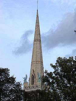
Upper Clapton is home to one of London's more unusual churches, the Church of the Good Shepherd, which was used as a place of worship by the Ancient Catholic Church and now is used by the Georgian Orthodox Church. However, the church was originally built by the Agapemonite cult in 1892 as the Church of the Ark of the Covenant.
The Agapemonites, who held decidedly unconventional views on marriage and the role of women, relocated to Upper Clapton from their spiritual community in Spaxton, Somerset, and had clearly prospered by this time. Although it is fairly conventional in floor plan, the outside of the church is a riot of statuary and symbolism. The main doorways sport large carvings of angels and the four evangelists symbolised by a man, an eagle, a bull and a lion. The same four figures, cast in bronze, look out over the four quarters of the Earth from the base of the steeple. The two flanking weather vanes show a certain symbolic debt to William Blake's Jerusalem depicting, as they do, a fiery chariot and a sheaf of arrows (presumably of desire), while the main steeple is clearly surmounted by a spear. The stained glass windows, designed by noted children's book illustrator Walter Crane, and made by J S Sparrow,[7] betray the unconventional nature of the sect as they illustrate the 'true station of womankind'.
The church, which was completed in 1895, was designed by Joseph Morris in a Gothic Revival style; for its "curiosity value" it was designated a Grade II-listed building on 12 September 1969.[8]

The cult had always been surrounded by scandal during its sojourn in Somerset and, after the move to Clapton, this degenerated into sheer farce. The original leader, Henry James Prince, who claimed to be immortal, died in 1899 and was succeeded by the charming but philandering John Hugh Smyth-Pigott, who wasted no time before declaring himself as the Messiah. Challenged by a jeering mob to prove his godhood by walking across Clapton Pond, Smyth-Pigott declined and retired to Somerset, where he was said to enjoy the favours of as many as seven "spiritual brides" a week. Smyth-Pigott, who also claimed immortality, died in 1927, after which the cult went into decline. The Clapton church had already been abandoned by the cult and was acquired first by the Ancient Catholic Church in 1956, and then by the Georgian Orthodox Church in 2005.[9]
The New Synagogue

Close by the Good Shepherd is the stately New Synagogue, on the eastern side of Clapton Common. This Grade II listed building[10] is a little deceptive, appearing much older than it actually is. In spite of its handsome Georgian-style exterior, this is actually post-Edwardian, built in 1915. It is, however, a faithful replica of an earlier building, the Great St Helen's Synagogue in the City of London, which was designed by John Davies in 1838. The current building contains a number of original fixtures from its predecessor. Endangered for a while, the synagogue was restored in 2005.
Brooke House

A large house known as the King's House stood on the site now occupied by BSix Sixth Form College, as early 1476. The house was within a 200-acre (0.81 km2) estate, which was described as the Manor of Hackney from about 1532 to the early 17th century — although there were two other manors in the south of the Parish.[11]
In 1532, Henry Algernon Percy, Earl of Northumberland, acquired the estate from Sir Richard Neville. However, in January 1535 the land was taken by Henry VIII; in settlement of a debt. The King visited the house in April 1535 and on 24 September 1535 he granted his "manor or principal messuage of Hackney" to Thomas Cromwell, his chief minister. Cromwell refurbished the house, and on 1 May 1536, returned the house to the King. In July 1536, Ralph Sadleir[12] brought Mary I of England to the house to swear the Oath of Supremacy before her father, and Jane Seymour, the Queen. Henry continued to own the house until his death in January 1547.[11] Edward de Vere, 17th Earl of Oxford, died in the house in Hackney known as the "King's House" on 24 June 1604.
The name of the house derives from its purchase by Fulke Greville, 1st Baron Brooke, in 1621 — which led to ownership by the family for over 200 years. The house became tenanted after 1724, but in 1758–9 the house was modified by a leasee, William Clarke who converted it to a lunatic asylum. The site remained in this use until 1940.[11]
The remains of the house were destroyed by enemy action in October 1940. 5.5 acres (0.02 km2) of Brooke House were purchased by the London County Council in 1944, and further bomb damage occurred that year. The house was finally demolished in 1954, and archaeological investigations of the Tudor palace took place in 1955–6. New school buildings were erected in 1960, designed by Armstrong and MacManus.[11]
Education
BSix Sixth Form College is a sixth form college on a site near the Lea Bridge roundabout in Clapton.
Transport and locale

About 2 miles by bus, the nearest London Underground stations are Tottenham Hale, Manor House and Seven Sisters.
- Nearest railway stations
 |
South Tottenham | Walthamstow Marshes | Walthamstow | |
| Stamford Hill | |
Leyton | ||
| ||||
| | ||||
| Stoke Newington | Lower Clapton | Lea Bridge |
References
- ↑ 'Hackney: Clapton', A History of the County of Middlesex. 10. 1995. pp. 44–51. Retrieved 2011-05-17.
- ↑ Mendick, Robert; Johnson, Andrew (2002-01-06). "Eight men shot dead in two years. Welcome to Britain's Murder Mile". The Independent. Retrieved 2011-05-17.
- ↑ Thompson, Tony (2001-04-22). "Two more die on 'murder mile'". The Guardian. Retrieved 2011-05-17.
- ↑ "Decline", Brass Eye, 1997, Channel4
- ↑ "White Lodge, Hackney". www.britishlistedbuildings.co.uk. Retrieved 31 January 2013.
- ↑ Hackney Today 188 21 July 2008
- ↑ The National Heritage List for England, entry 1235310
- ↑ Historic England. "Details from image database (425966)". Images of England. accessed 22 January 2009
- ↑ The Georgian Orthodox Church, London Parish of Saint George
- ↑ Historic England. "Details from image database (426739)". Images of England. accessed 22 January 2009
- 1 2 3 4 Documentary evidence, Survey of London: volume 28: Brooke House, Hackney (1960), pp. 52-66. Date accessed: 22 January 2009
- ↑ Sadleir had been a member of Cromwell's household, and was appointed Henry's Secretary of State for Scotland
External links
- History of Clapton. British History Online. Retrieved October 30, 2016.
- "Upper Clapton" at freeservers.com. Retrieved October 30, 2016.
- "New Synagogue, Egerton Road" from www.oldsynagogues.org. Retrieved October 30, 2016.
| Districts |  | |
|---|---|---|
| Attractions | ||
| Parks and open spaces | ||
| Street markets | ||
| Constituencies | ||
| Tube and rail stations | ||
| Other topics | ||