Mary D, Pennsylvania
| Mary D | |
|---|---|
| Unincorporated community | |
|
Main Street in Mary D. | |
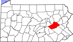
 Mary D Location within the state of Pennsylvania | |
| Coordinates: 40°45′36″N 76°3′22″W / 40.76000°N 76.05611°WCoordinates: 40°45′36″N 76°3′22″W / 40.76000°N 76.05611°W | |
| Country | United States |
| State | Pennsylvania |
| County | Schuylkill |
| Elevation | 906 ft (276 m) |
| Time zone | Eastern (EST) (UTC-5) |
| • Summer (DST) | EDT (UTC-4) |
| ZIP codes | 17952 |
| Area code(s) | 570 Exchange: 668 |
| GNIS feature ID | 1180517[1] |

Mary D is an unincorporated community and coal town in Schuylkill County, Pennsylvania, United States. It is located in Schuylkill Township on U.S. Route 209 and the Schuylkill River forms its natural SE boundary.
History
The community derives its name from Mary Delores Dodson, the wife of a local mine owner.[2]
References
- ↑ U.S. Geological Survey Geographic Names Information System: Mary D, Pennsylvania
- ↑ Mihalik, Pattie (Jan 30, 1986). "Small town boasts devoted residents". Kentucky New Era. pp. 7B. Retrieved 18 October 2015.
 |
Ryan Township | Locust Valley | Tuscarora | |
| Blythe Township | |
Walker Township | ||
| ||||
| | ||||
| Brockton | Walker Township | Walker Township |
| Wikimedia Commons has media related to Mary D, Pennsylvania. |
This article is issued from Wikipedia - version of the 10/18/2015. The text is available under the Creative Commons Attribution/Share Alike but additional terms may apply for the media files.