Maalbeek/Maelbeek metro station
Maalbeek Maelbeek | ||||||||||||||||
|---|---|---|---|---|---|---|---|---|---|---|---|---|---|---|---|---|
.jpg) | ||||||||||||||||
| Coordinates | 50°50′38″N 4°22′36″E / 50.84389°N 4.37667°ECoordinates: 50°50′38″N 4°22′36″E / 50.84389°N 4.37667°E | |||||||||||||||
| Owned by | STIB/MIVB | |||||||||||||||
| Services | ||||||||||||||||
| ||||||||||||||||
Maalbeek (Dutch, pronounced [ˈmaːlbeːk]) or Maelbeek (French, ancient Dutch spelling) is a Brussels Metro station in the City of Brussels. The name of the station originates from a stream named Maalbeek. It is served by lines 1 and 5.
History
It was inaugurated on 17 December 1969 as a premetro station (i.e., with trams instead of trains) as part of the first underground public transport route in Belgium that initially stretched from De Brouckère to Schuman. In 1976, this premetro line was converted into a heavy metro line that was later split into two distinct lines in 1982: lines 1A and 1B, both of which serve Maelbeek/Maalbeek. As of 4 April 2009 the lines were reorganised and renumbered 1 and 5.
2016 Brussels bombings
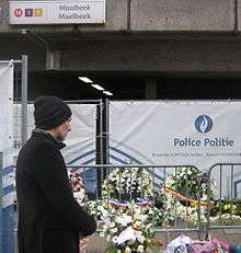

On 22 March 2016 at 09:11 CET, an explosion took place at the Maelbeek/Maalbeek metro station. The bomb exploded from the second carriage of a four carriage train as it started to leave the Maelbeek/Maalbeek station and head in the direction of Arts-Loi/Kunst-Wet. The Islamic State of Iraq and the Levant released a statement claiming responsibility for the attack and branding Belgium a participant in the ongoing Military intervention against ISIL. The suicide attack took place about an hour after the bombings took place in Brussels Airport. The Flemish radio and television organisation VRT officially reported 20 people were killed at the metro station, with 106 injured.[1][2]
The station was closed for over a month following the attacks. On 25 April 2016, the Maalbeek station reopened again.[3]
Interior and art
The walls of the Maelbeek/Maalbeek platforms are decorated with white Azulejo tiles manufactured in Portugal.[4] Benoît van Innis was commissioned to paint eight portraits on the walls.
Location
The station is located under the Rue de la Loi/Wetstraat, a street best known for the many official buildings of the European Parliament, European Union, European Commission and Belgian Government. One of the station's exits leads to Rue de la Loi/Wetstraat, with a side entrance leading to Rue Joseph II/Jozef II Straat. The other exit leads to the Chaussée d'Etterbeek/Etterbeekse steenweg. It is located under the bridge carrying the Rue de la Loi/Wetstraat. Close nearby (also on Chaussée d'Etterbeek/Etterbeekse steenweg) is an entrance leading to the SNCB/NMBS (heavy rail) southbound platforms of Schuman railway stations; this entrance is located under the railway bridge with stairs up to the platforms.
Nearby locations
References
- ↑ "Brussels attacks 'leave 13 dead'".
- ↑ "Ook aanslag op metronetwerk Brussel". telegraaf.nl.
- ↑ Morgan, Kellie. "Brussels metro station reopens after terror attack". cnn.com. CNN. Retrieved 25 April 2016.
- ↑ "The art of the underground (2): Metro Maalbeek".
External links
 Media related to Maalbeek/Maelbeek metro station at Wikimedia Commons
