Lyndon, Kansas
| Lyndon, Kansas | |
|---|---|
| City | |
|
Downtown Lyndon (2009) | |
 Location within Osage County and Kansas | |
 KDOT map of Osage County (legend) | |
| Coordinates: 38°36′37″N 95°41′7″W / 38.61028°N 95.68528°WCoordinates: 38°36′37″N 95°41′7″W / 38.61028°N 95.68528°W | |
| Country | United States |
| State | Kansas |
| County | Osage |
| Area[1] | |
| • Total | 0.83 sq mi (2.15 km2) |
| • Land | 0.83 sq mi (2.15 km2) |
| • Water | 0 sq mi (0 km2) |
| Elevation | 1,033 ft (315 m) |
| Population (2010)[2] | |
| • Total | 1,052 |
| • Estimate (2012[3]) | 1,040 |
| • Density | 1,300/sq mi (490/km2) |
| Time zone | Central (CST) (UTC-6) |
| • Summer (DST) | CDT (UTC-5) |
| ZIP code | 66451 |
| Area code | 785 |
| FIPS code | 20-43350 [4] |
| GNIS feature ID | 0479609 [5] |
| Website | LyndonKS.gov |

Lyndon is a city in and the county seat of Osage County, Kansas, United States.[6] As of the 2010 census, the city population was 1,052.[7]
History
Lyndon was founded in 1869 after the land in the area was taken from the Sac and Fox Nation and opened for settlement.[8] It was named after Lyndon, Vermont.[9]
Geography
Lyndon is located at 38°36′37″N 95°41′7″W / 38.61028°N 95.68528°W (38.610233, -95.685352).[10] According to the United States Census Bureau, the city has a total area of 0.83 square miles (2.15 km2), all land.[1]
Climate
The climate in this area is characterized by hot, humid summers and generally mild to cool winters. According to the Köppen Climate Classification system, Lyndon has a humid subtropical climate, abbreviated "Cfa" on climate maps.[11]
Demographics
| Historical population | |||
|---|---|---|---|
| Census | Pop. | %± | |
| 1890 | 935 | — | |
| 1900 | 1,004 | 7.4% | |
| 1910 | 763 | −24.0% | |
| 1920 | 732 | −4.1% | |
| 1930 | 742 | 1.4% | |
| 1940 | 751 | 1.2% | |
| 1950 | 729 | −2.9% | |
| 1960 | 953 | 30.7% | |
| 1970 | 958 | 0.5% | |
| 1980 | 1,132 | 18.2% | |
| 1990 | 964 | −14.8% | |
| 2000 | 1,038 | 7.7% | |
| 2010 | 1,052 | 1.3% | |
| Est. 2015 | 1,023 | [12] | −2.8% |
| U.S. Decennial Census | |||
Lyndon is part of the Topeka metropolitan area.
2010 census
As of the census[2] of 2010, there were 1,052 people, 422 households, and 285 families residing in the city. The population density was 1,267.5 inhabitants per square mile (489.4/km2). There were 464 housing units at an average density of 559.0 per square mile (215.8/km2). The racial makeup of the city was 97.5% White, 0.4% African American, 0.7% Native American, 0.1% Asian, and 1.3% from two or more races. Hispanic or Latino of any race were 1.0% of the population.
There were 422 households of which 37.0% had children under the age of 18 living with them, 53.8% were married couples living together, 10.9% had a female householder with no husband present, 2.8% had a male householder with no wife present, and 32.5% were non-families. 29.1% of all households were made up of individuals and 13.8% had someone living alone who was 65 years of age or older. The average household size was 2.45 and the average family size was 3.02.
The median age in the city was 36.8 years. 28% of residents were under the age of 18; 6.1% were between the ages of 18 and 24; 26.2% were from 25 to 44; 25.7% were from 45 to 64; and 13.9% were 65 years of age or older. The gender makeup of the city was 50.9% male and 49.1% female.
2000 census
As of the census[4] of 2000, there were 1,038 people, 419 households, and 297 families residing in the city. The population density was 1,387.5 people per square mile (534.4/km²). There were 453 housing units at an average density of 605.5 per square mile (233.2/km²). The racial makeup of the city was 97.98% White, 0.48% Native American, 0.19% Asian, 0.10% Pacific Islander, 0.77% from other races, and 0.48% from two or more races. Hispanic or Latino of any race were 0.77% of the population.
There were 419 households out of which 32.9% had children under the age of 18 living with them, 58.5% were married couples living together, 8.4% had a female householder with no husband present, and 28.9% were non-families. 24.8% of all households were made up of individuals and 15.5% had someone living alone who was 65 years of age or older. The average household size was 2.46 and the average family size was 2.91.
In the city the population was spread out with 26.0% under the age of 18, 7.0% from 18 to 24, 26.3% from 25 to 44, 22.4% from 45 to 64, and 18.2% who were 65 years of age or older. The median age was 39 years. For every 100 females there were 101.6 males. For every 100 females age 18 and over, there were 91.0 males.
The median income for a household in the city was $36,250, and the median income for a family was $44,231. Males had a median income of $33,750 versus $19,671 for females. The per capita income for the city was $16,968. About 7.8% of families and 10.9% of the population were below the poverty line, including 12.4% of those under age 18 and 14.7% of those age 65 or over.
Gallery
 Lyndon City Hall, 2009
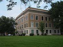 Osage County Courthouse, 2009
 Aerial view of Lyndon, 2013
See also
- National Register of Historic Places listings in Osage County, Kansas
- Melvern Lake
- Pomona State Park
References
- 1 2 "US Gazetteer files 2010". United States Census Bureau. Retrieved 2012-07-06.
- 1 2 "American FactFinder". United States Census Bureau. Retrieved 2012-07-06.
- ↑ "Population Estimates". United States Census Bureau. Retrieved 2013-05-29.
- 1 2 "American FactFinder". United States Census Bureau. Retrieved 2008-01-31.
- ↑ "US Board on Geographic Names". United States Geological Survey. 2007-10-25. Retrieved 2008-01-31.
- ↑ "Find a County". National Association of Counties. Retrieved 2011-06-07.
- ↑ "2010 City Population and Housing Occupancy Status". U.S. Census Bureau. Retrieved March 27, 2011.
- ↑ Blackmar, Frank Wilson (1912). Kansas: A Cyclopedia of State History, Volume 2. Standard Publishing Company. p. 195.
- ↑ Kansas State Historical Society (1916). Biennial Report of the Board of Directors of the Kansas State Historical Society. Kansas State Printing Plant. p. 255.
- ↑ "US Gazetteer files: 2010, 2000, and 1990". United States Census Bureau. 2011-02-12. Retrieved 2011-04-23.
- ↑ Climate Summary for Lyndon, Kansas
- ↑ "Annual Estimates of the Resident Population for Incorporated Places: April 1, 2010 to July 1, 2015". Retrieved July 2, 2016.
Further reading
- History of the State of Kansas; William G. Cutler; A.T. Andreas Publisher; 1883. (Online HTML eBook)
- Kansas : A Cyclopedia of State History, Embracing Events, Institutions, Industries, Counties, Cities, Towns, Prominent Persons, Etc; 3 Volumes; Frank W. Blackmar; Standard Publishing Co; 944 / 955 / 824 pages; 1912. (Volume1 - Download 54MB PDF eBook),(Volume2 - Download 53MB PDF eBook), (Volume3 - Download 33MB PDF eBook)
External links
| Wikimedia Commons has media related to Lyndon, Kansas. |
- City
- Schools
- USD 421, local school district
- Maps
- Lyndon City Map, KDOT
Municipalities and communities of Osage County, Kansas, United States | ||
|---|---|---|
| Cities |  | |
| CDP | ||
| Unincorporated communities | ||
| Townships |
| |