Lynch, Kentucky
| Lynch, Kentucky | |
|---|---|
| City | |
|
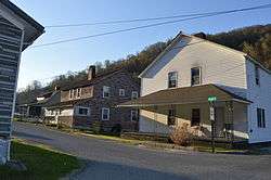
Houses at Lynch's western end | |
 Location of Lynch, Kentucky | |
| Coordinates: 36°57′54″N 82°55′00″W / 36.96500°N 82.91667°WCoordinates: 36°57′54″N 82°55′00″W / 36.96500°N 82.91667°W | |
| Country | United States |
| State | Kentucky |
| County | Harlan |
| Incorporated | May 7, 1963 |
| Named for | Thomas Lynch, the head of U.S. Coal and Coke |
| Government | |
| • Mayor | John Adams |
| Area | |
| • Total | 0.3 sq mi (0.8 km2) |
| • Land | 0.3 sq mi (0.8 km2) |
| • Water | 0.0 sq mi (0.0 km2) |
| Elevation | 1,716 ft (523 m) |
| Population (2010) | |
| • Total | 747 |
| • Density | 2,490.0/sq mi (933.8/km2) |
| Time zone | Eastern (EST) (UTC-5) |
| • Summer (DST) | EDT (UTC-4) |
| ZIP code | 40855 |
| Area code(s) | 606 |
| FIPS code | 21-48540 |
| GNIS feature ID | 0497363 |
Lynch is a 5th-class city in Harlan County, Kentucky, in the United States. In the 2010 census, the city population was 747, down from 900 in 2000.
History
It was plotted in 1917 by the U.S. Coal and Coke Company (a subsidiary of U.S. Steel) as a company town to house workers at the company's nearby coal mines. It was named for then-head of the company, Thomas Lynch. By the 1940s, Lynch had a population of more than 10,000 and had such amenities as a hospital and movie theater. The population declined dramatically in the 1960s and 1970s as mining techniques shifted to less labor-intensive methods.
Geography
Lynch is located at 36°57′54″N 82°55′00″W / 36.965133°N 82.916569°W (36.965133, -82.916569).[1] According to the United States Census Bureau, the city has a total area of 0.3 square miles (0.78 km2), all of it land.
Lynch is the nearest city to Kentucky's highest point, Black Mountain (elevation 4,145 ft). Sitting at an elevation of 1,716 feet above sea level, Lynch is Kentucky's highest incorporated city. Lynch is adjacent to Appalachia, Virginia.
Demographics

As of the census[2] of 2000, there were 900 people, 408 households, and 250 families residing in the city. The population density was 2,753.1 people per square mile (1,053.0/km²). There were 514 housing units at an average density of 1,572.3/sq mi (601.4/km²). The racial makeup of the city was 73.33% White, 24.89% Black or African American, 0.33% Native American, and 1.44% from two or more races. Hispanic or Latino of any race were 0.33% of the population.
| Historical population | |||
|---|---|---|---|
| Census | Pop. | %± | |
| 1970 | 1,517 | — | |
| 1980 | 1,614 | 6.4% | |
| 1990 | 1,166 | −27.8% | |
| 2000 | 900 | −22.8% | |
| 2010 | 747 | −17.0% | |
| Est. 2015 | 709 | [3] | −5.1% |
There were 408 households out of which 24.0% had children under the age of 18 living with them, 40.7% were married couples living together, 16.2% had a female householder with no husband present, and 38.5% were non-families. 36.8% of all households were made up of individuals and 20.1% had someone living alone who was 65 years of age or older. The average household size was 2.21 and the average family size was 2.88.
In the city the population was spread out with 22.6% under 18, 8.9% from 18 to 24, 20.4% from 25 to 44, 28.2% from 45 to 64, and 19.9% who were 65 or older. The median age was 43 years. For every 100 females there were 82.6 males. For every 100 females age 18 and over, there were 80.1 males.
The median income for a household in the city was $17,609, and the median income for a family was $21,625. Males had a median income of $31,500 versus $19,038 for females. The per capita income for the city was $13,369. About 36.7% of families and 37.8% of the population were below the poverty line, including 57.6% of those under age 18 and 25.9% of those age 65 or over.
Notable people
- Louise Slaughter, US Congresswoman from New York
- Juanita M. Kreps, United States Secretary of Commerce
See also
References
- ↑ "US Gazetteer files: 2010, 2000, and 1990". United States Census Bureau. 2011-02-12. Retrieved 2011-04-23.
- ↑ "American FactFinder". United States Census Bureau. Retrieved 2008-01-31.
- ↑ "Annual Estimates of the Resident Population for Incorporated Places: April 1, 2010 to July 1, 2015". Retrieved July 2, 2016.
- ↑ "Census of Population and Housing". Census.gov. Retrieved June 4, 2015.

