Lists of castles in Ireland
This List of Castles in Ireland, be they in the Northern Ireland and thus United Kingdom or in the Republic of Ireland, is organized by county within their respective country.
 Republic of Ireland
Carlow
| Name | Image | Location | Type | Date | Notes |
|---|---|---|---|---|---|
| Ballyloughan Castle | 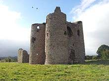 |
Bagenalstown 52°40′22.5″N 6°53′53.1″W / 52.672917°N 6.898083°W | Castle | 13th Century[1] | A ruined castle located near Bagenalstown featuring one of the finest gatehouses in Ireland.[2] The castle’s architecture would suggest that the castle was built by a Norman lord c. 1300 and was likely abandoned in the 14th Century.[3][4] Near the end of the 16th Century, the castle was occupied by the Kavanghs and then passed to the Bagenals, and then finally to the Bruens in the 19th Century.[4] |
| Ballymoon Castle |  |
Muine Bheag 52°42′0″N 6°54′25.2″W / 52.70000°N 6.907000°W | Norman Castle | 13th Century[5] | Almost no history is available on the castle, but it seems that Ballymoon was built either by Roger Bigod or a member of the Carews between 1290 and 1310, likely to defend the Barrow river valley from Irish raiders.[5][6] |
| Carlow Castle |  |
Carlow 52°50′11″N 6°56′9″W / 52.83639°N 6.93583°W | Castle | 1209[7] | A once mighty fortress erected by William Marshall upon the site of a motte-and-bailey built by Hugh de Lacy in 1180.[8] The castle has seen combat in the Silken Thomas Rebellion, an attack by Rory Oge O'Moore in 1577 the Irish Rebellion of 1641, Irish Confederate Wars, and the Conquest of Ireland by Oliver Cromwell.[7][8] In 1813, the castle was leased to a Dr. Phillip Parry Price Middleton,[9] who attempted to renovate it into a mental asylum in 1814.[10] The castle was demolished after a partial collapse caused by an explosion and abandoned until 1996 when the castle was given to the care of the Office of Public Works.[9][11] |
| Huntington Castle |  |
Clonegal 52°41′23.28″N 6°38′54.96″W / 52.6898000°N 6.6486000°W | Country house | 1625 | A castle constructed by the Esmonde family in 1625,[12] after Queen Elizabeth I’s forces captured the area, gave it to the Nettervilles, who then gave it to the Esmondes. A branch of the family, the Robertsons, still maintain ownership of the castle and it still serves as their ancestral home. Despite this, the castle is open to the public.[13] In addition to a shrine to the Egyptian goddess Isis, the castle is noted as being haunted.[14] |
| Leighlinbridge Castle, or Black Castle of Leighlinbridge |  |
Leighlinbridge 52°44′8.52″N 6°52′41.16″W / 52.7357000°N 6.8781000°W | Bawn | 1547 | A castle built by Hugh de Lacy in 1180 to defend the river crossing,[15][16] rebuilt by John de Clahull in 1181,[17] and once again in 1547 by Edward Bellingham after its destruction in the 14th Century by the Cavanaghs. The castle was sacked again by Cromwellian forces under Colonel Hewson in 1650 during the Irish Confederate Wars.[18] |
| Tinnahinch Castle |  |
52°31′48″N 6°57′0″W / 52.53000°N 6.95000°W | Country house | c. 1620[19] | Tinnahinch Castle was built in the early 17th Century by James Butler to control a bridge that once stood on this spot and was confiscated from him for his involvement in the Rebellion of 1641.[20] The castle burned down in 1700 and remains a ruin.[21] |
Cavan
| Name | Image | Location | Type | Date | Notes |
|---|---|---|---|---|---|
| Bailieborough Castle |  |
Bailieborough 52°44′8.52″N 6°52′41.16″W / 52.7357000°N 6.8781000°W | Country house | 1629 | Also known as "Castle House" or "Lisgar House," Bailieborough Castle was built in 1689, was attacked by Irish rebel forces under Colonel Hugh O’Reilly in 1641, and then was demolished in 1923.[22] |
| Ballyconnell Castle |  |
Ballyconnell 54°7′0″N 7°35′0″W / 54.11667°N 7.58333°W | Bawn | 1620 | An early 17th Century Plantations-era castle built by a Capt. Culme and Walter Talbot that burned down in 1764.[22] The castle was rebuilt as Ballyconnell House by a “G. Montgomery.”[23] |
| Cabra Castle |  |
Carrickmacross 53°54′36″N 6°46′48″W / 53.91000°N 6.78000°W | Mansion | c. 1810 | There are two castles on the estate, but has been a ruin since its destruction by Cromwell’s forces. An early Gothick and Norman style mansion built in the 1810s for the Fosters, a local Ascendancy family, and was locally known as Cormey House after the townland it was located in. However, the castle’s construction bankrupted the family, so they sold it to the Pratts, another Ascendancy family. Today, the castle and estate functions as a hotel.[24] |
| Saunderson Castle |  |
Belturbet 54°7′30″N 7°21′7.2″W / 54.12500°N 7.352000°W | Mansion | c. 1840[25] | In the 1840s, the Saunderson family built a new mansion upon the land they had owned since the early 17th century and used it as their seat until 1977 when it was sold to a London based business man. His plans to renovate the castle didn’t come to fruition, and so the castle was sold again in 1990.[25] Seven years later, the castle and estate were purchased by Scouting Ireland (CSI) and is now open to the public for most of the year. |
| Cloughoughter Castle | 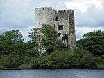 |
Belturbet 54°1′7.48″N 7°27′17.28″W / 54.0187444°N 7.4548000°W | Castle | 1233 | An ancient castle, possibly built on a crannóg,[26] built by the O’Rourkes, the Anglo-Normans and finished by the O'Reilly clan in 1233.[27][28] After their 300-year long possession of the castle, during which they imprisoned Philip O’Reilly here in the 1360s, the castle was given to Captain Hugh Clume, and was then demolished by Cromwellian forces in 1653.[29] |
Clare
- An Rath Ringfort
- Ballymarkahan Castle
- Ballinalacken Castle, Hotel
- Ballyhannon Castle
- Ballyportry Castle
- Boston Castle
- Bunratty Castle, Restored Castle
- Caherconnell Stone Fort
- Caherminnaun Castle (site of)
- Callaun Castle
- Carrigaholt Castle
- Castle Crine
- Castlefergus House
- Castlelake House
- Castle View
- Craggaunowen Castle
- Doolin Castle
- Doonagore Castle
- Doonbeg castle
- Dromoland Castle, Restored Castle, Hotel
- Dromore Castle
- Dunmackelim Castle
- Freagh Castle
- Gleninagh Castle
- Gragan Castle
- Inchiquin Castle, Castle Ruins
- Kiltanon Castle
- Knappogue Castle, Restored Castle
- Knockalish Fort
- Leamaneh Castle, Castle Ruins
- Milltown Castle
- Moher Castle
- Moher Tower
- Newtown Castle, Restored Castle
- O'Brien's Tower
- O'Dea Castle
- Teerobannan Castle
- Tromra Castle
- Tuamgraney Castle
- Tullagh Fort
- Tyredagh Castle
Cork

- Aghamarta Castle
- Aghamhaoila Castle
- Ballea Castle
- Ballinacarriga Castle
- Ballincollig Castle
- Ballintotis Castle
- Ballybeg Castle
- Ballyclogh Castle
- Ballyhooly Castle
- Ballymaloe Castle
- Ballynamona Castle
- Ballyrobert Castle
- Barryscourt Castle, Restored Castle. OPW info
- Belvelly Castle
- Ballyva Manor, built in the 1850s by Timothy Hurley.
- Blackrock Castle, Restored Castle
- Blackwater Castle, Restored Castle
- Blarney Castle, Restored Castle
- Buttevant Castle
- Carrigacunna Castle
- Carrigadrohid Castle
- Carrignamuck Castle
- Carriganass Castle
- Carrigaphooca Castle
- Carrigboy Castle
- Carrignacurra Castle
- Carrigrohane Castle
- Castle Barrett
- Castle Bernard
- Castle Cooke
- Castle Donovan (Sowagh), ruins in process of restoration[30]
- Castle Downeen
- Castle Eyre
- Castle Freke, ruin in process of restoration
- Castle Harrison[31]
- Castle Hyde
- Castle Kevin
- Castle Lishen
- Castle Lyons
- Castle Magner
- Castlemahon
- Castle Mallow
- Castlemartyr
- Castle Mary
- Castle Park
- Castle Pook
- Castle Richard
- Castle Ringaskidy
- Castlesaffron
- Castle Salem
- Castle Townsend
- Castle Treasure
- Castle Warren
- Castle Widenham
- Castle White
- Castle Wrixon
- Castleminsters
- Conna Castle
- Coolmaine Castle, Restored Castle Currently Owned by Roy Disney
- Coppingerstown Castle
- Coppingers Court
- Cor Castle
- Creagh Castle
- Cregg Castle
- Crowley Castle
- Davis' Castle
- Desmond Castle
- Dripsey Castle
- Drishane Castle, Restored Castle
- Dromagh Castle
- Dromaneen Castle
- Duarrigle Castle
- Dunalong Castle
- Dunasead Castle
- Dunboy Castle
- Dundareirke Castle,Castle Ruins
- Dunlough Castle, or Three Castles Head
- Dunmahon Castle
- Dunmanus Castle, Castle Ruins
- Enchicrenagh Castle ruin
- Eustace’s Castle
- Garryvoe Castle, Tower House Ruins
- Glengarriff Castle
- Gortmore Castle
- Ightermurragh Castle, Castle Ruins
- Kanturk Castle
 Abandoned gatehouse, leading to Lohort Castle may have been constructed at the time the castle was renovated during the 1740s.
 - Kilbolane Castle
- Kilbrittain Castle, Restored Castle
- Kilcaskan Castle
- Kilkoe castle = Jeremy Irons Castle
- Kilcor Castle
- Kilcrea Castle, Castle Ruins
- Kilnannan Castle
- Lohort Castle
- Lumbard´s Castle
- Macroom Castle, Castle Ruins
- Mallow Castle, Castle Ruins
- Milltown Castle
- Mistletoe Castle
- Mitchelstown Castle, Demolished
- Mogeely Castle
- Monanimy Castle
- Monkstown Castle
- Mountlong Castle
- Rathberry Castle ruin
- Ringrone Castle
- Rostellan Castle
- Siddon's Tower
- Tyntes Castle
- Wallstown Castle
- Widenham Castle, Restored Castle
Donegal
- Ballyshannon Castle
- Burt Castle
- Carrickabraghy Castle
- Doe Castle/Caisleán na dTuath, Restored Castle
- Donegal Castle, Restored Castle.
- Drumboe Castle
- Glenveagh Castle, Complete Castle
- Monellan Castle
- Mongavlin Castle
- Greencastle, Castle Ruins
- O'Doherty Castle, Castle Ruins
- Rahan Castle, Castle Ruins
- Raphoe Castle, Castle Ruins
Dublin
- Ardgillan Castle, Ardgillan Demesne, Balrothery
- Artaine Castle, Artaine
- Ashtown Castle, Phoenix Park. OPW info
- Athgoe Castle, Newcastle, intact, NIAH survey
- Ballyowen Castle, Lucan, ruins incorporated into the Ballyowen Castle Shopping Centre
- Balrothery Castle, intact
- Baymount Castle, Heronstown, Clontarf
- Belgard Castle, Tallaght, HQ of CRH Holdings
- Bremore Castle, Balbriggan, under repair
- Bullock Castle
- Carrickmines Castle, ruins, buried beneath recent road work
- Castle Bagot, Kilmactalway, Newcastle, intact, health spa
- Castle Mount, Clogh
- Castle Park (Castle Perrin), Monkstown, intact, NIAH survey
- Castleknock Castle
- Cheeverstown
- Clonskeagh Castle, Roebuck. 19th century, on site of earlier castle.
- Clontarf Castle, Clontarf. Restored Castle, Hotel. NIAH survey
- Conn Castle, intact
- Dalkey, 2 remaining of original 7 castles
- Donabate, intact
- Drimnagh Castle, Drimnagh. Restored Castle. NIAH survey
- Drumcondra Castle, Richmond. Conference centre
- Dublin Castle, Dublin City. Restored Castle
- Dundrum Castle, Dundrum. Ruins
- Dunsoghly Castle, Restored Castle
- Howth Castle, Howth.NIAH survey
- Grange, intact?
- Irishtown Castle, ruin
- Kilgobbin Castle, ruin, History
- Killiney Castle, Scalpwilliam or Mount Mapas.NIAH survey
- Killininny Castle, Firhouse
- Kilsallaghan Castle
- Knocklyne (Knocklyon) Castle, Knocklyon. Intact, private residence. NIAH survey
- Lambay Castle, Lambay Island NIAH survey
- Lanestown, intact
- Luttrellstown Castle, Restored Castle
- Merrion Castle
- Malahide Castle, Malahide Demesne. Restored Castle
- Merrion Castle, Merrion.
- Monkstown Castle, Monkstown Castlefarm. Ruin
- Murphystown, ruins, the proposed Luas line B1 runs approximately 28m west of the ruins of Murphystown Castle and through its area of archaeological potential.
- Nangor Castle, Nangor.
- Portrane (Stella's Tower), intact
- Puck's Castle, Shankill. brief history & photos, Ruin
 Puck's Castle
 - Rathfarnham Castle, Rathfarnham Demesne. Restored Castle
- Rathmines Castle, Rathmines West. NIAH survey
- Robswall, intact
- Roebuck Castle, Roebuck. Hall of residence UCD campus NIAH survey
- Sarsfield Castle, intact
- Seatown
- Shangannagh Castle, ruins, not to be confused with the late 18th-century house of the same name
- Shankill Castle, Shankill. NIAH survey, brief history, Ruin
- Simmonscourt Castle, Smotscourt.NIAH survey
- Stillorgan Castle, Stillorgan. 18th-century house on site of earlier castle, now incorporated into the modern St John of God hospital complex. NIAH survey
- Swords Castle, Castle Ruins, undergoing restoration
- Templeogue House NIAH survey
- Thorncastle
- Tully's Castle, Clondalkin, ruins, Picture
- Tymon Castle, Tymon North. Demolished in the 1970s
- Williamstown Castle, Williamstown.NIAH survey
Galway
- Abbeyglen Castle, Restored Castle website
- Ardamullivan Castle, Restored Castle
- Athenry Castle, Restored Castle info
- Aughnanure Castle, Intact Castle
- Ballindooley Castle, Restored Castle
- Ballinfad Castle, Intact Castle
- Ballymore Castle, Restored Castle
- Ballynahinch Castle, Intact Castle
- Caheradangan Castle, Intact Castle
- Cargin Castle, Restored Castle
- Castle Ellen, Restored Castle
- Castle Kirk, Castle Ruins
- Castletown Castle, Castle Ruins
- Clifden Castle, Castle Ruins
- Cloghan Castle, Restored Castle
- Cloonacauneen Castle, Restored Castle
- Cregg Castle, Restored Castle
- Dunguaire Castle, Restored Castle
- Dunsandle Castle, Restored Castle
- Eyrecourt Castle, Castle Ruins
- Feartagar Castle, Castle Ruins
- Fiddaun Castle, Castle Ruins
- Garbally Castle, Castle Ruins
- Glinsk Castle, Castle Ruins
- Hackett Castle, Castle Ruins
- Kilcolgan Castle, Intact Castle
- Kylemore Abbey, Benedictine Monastery
- Lynch's Castle, Restored Castle
- Menlow Castle (also Menlo or Menlough), Castle Ruins
- Monivea Castle, Castle Ruins
- Moyode Castle, Castle Ruins
- Oranmore Castle, Restored Castle
- Portumna Castle, Restored Castle
- Thoor Ballylee, W.B. Yeats' former holiday home, restored as a Museum. Currently closed after flooding.
Kerry
- Ardea Castle
- Ballybunnion Castle
 Ballybunnion Castle
 - Ballingarry Castle
- Ballinskelligs Castle
- Ballybunion Castle
- Ballycarbery Castle
- Ballyheigue Castle
- Ballymalis Castle
- Ballyseede Castle, Hotel
- Cappanacuss Castle
- Carrigafoyle Castle
- Carrignass Castle
- Castle Sybil
- Castle of the Island
- Derryquin Castle
- Dromore Castle
- Dunbeg Fort
- Dunkerron Castle
- Dunloe Castle
- Gallarus Castle
- Listowel Castle
- Minard Castle
- Parkavonear Castle
- Ross Castle, Restored Castle. OPW info
- Staigue Fort
Kildare
- Barberstown Castle, Restored Castle
- Barretstown Castle, Restored Castle
- Carbury Castle, Castle Ruins
- Grange Castle, Castle Ruins
- Jigginstown Castle (Sigginstown House), Castle Ruins Info
- Kildare Castle, Castle Ruins
- Kilkea Castle, Restored Castle
- Kilteel Castle, Intact Castle Info
- Leixlip Castle, Restored Castle
- Maynooth Castle, Intact Castle
- Rathcoffey Castle, Castle Ruins Info
- Rheban Castle, Castle Ruins Info
- White's Castle, Restored Castle
Kilkenny

- Annaghs Castle, Castle Ruins
- Ballinlaw Castle, Castle Ruins
- Ballybur Castle, Restored Castle[32]
- Ballyragget Castle, Castle Ruins
- Burnchurch Castle, Intact Castle
- Clara Castle, Intact Castle
- Coolhill Castle, Castle Ruins
- Corluddy Castle, Castle Ruins
- Currahill Castle, Castle Ruins
- Dunkitt Castle, Castle Ruins
- Foulksrath Castle, Intact Castle
- Gorteens Castle, Castle Ruins
- Gowran Castle, Castle Ruins
- Granagh Castle, Castle Ruins
- Kilbline Castle, Intact Castle
- Kilkenny Castle, Restored Castle. info
- Kilmurry Castle, Castle Ruins
- Maudlin Castle, Restored Castle
- Shankill Castle, Restored Castle
Laois
- Ballaghmore Castle, Restored Castle
- Ballyadams Castle, Castle Ruins
- Castle Durrow, Restored Castle
- Cullahill Castle, Castle Ruins
- Gortnaclea Castle, Castle Ruins
- Rock of Dunamase, Castle Ruins
- Shrule Castle, Castle Ruins
Leitrim
- Lough Rynn Castle, Restored Castle
- Manorhamilton Castle, Restored Castle
- Parke's Castle, Restored Castle. info
Limerick

Askeaton Castle
- Askeaton Castle
- Ballygrennan Castle
- Black Castle
- BeaghCastle ruin
- Bourchier's Castle
- Carrigogunnell Castle
- Castle Matrix
- Castle Oliver, also known as Clonodfoy,
- Castle Troy
- Croom Castle
- Desmond Castle
- Dromore Castle ruin
- Glin Castle (Old)
- Glin Castle, Hotel
- King John's Castle, Limerick City
- Lisnacullia Castle
- Rockstown Castle
- Springfield Castle, available for rent
- Williamstown Castle
Longford
- Castle Forbes, Restored Castle info
- Moydow Castle, Castle Ruins
Louth
- Ardee Castle, Restored Castle
- Barmeath Castle, Restored Castle
- Castle Bellingham, Intact Castle
- Castle Roche, Castle Ruins
- Castletown Castle, Restored Castle
- Darver Castle, Restored Castle
- Hatch's Castle, Intact Castle
- King John's Castle, Restored Castle
- Knockabbey Castle, Restored Castle
- The Mint, Restored Castle
- Smarmore Castle, Intact Castle
- Taaffe Castle, Castle Ruins
- Termonfeckin Castle, survivor of two tower houses, other demolished ca. 1800.
Mayo
- Aghalard Castle, Castle Ruins
- Ahena Castle, Castle Ruins.
- Ashford Castle, Intact Castle
- Belleek Castle, Restored Castle
- Deel Castle, Castle Ruins
- Doon Castle, Castle Ruins
- Kildavnet Castle, Intact Castle
- Kinlough Castle, Castle Ruins
- Rappa Castle, Castle Ruins
- Rockfleet Castle, Restored Castle
- Shrule Castle, Castle Ruins
- Turin Castle, Restored Castle
Dookinella castle
Meath
- The Black Castle, Castle Ruins
- Donore Castle, Castle Ruins
- Dunsany Castle, Restored Castle
- Lynches Castle (Summerhill), Castle Ruins
- Durhamstown Castle, Intact Castle
- Killeen Castle, Restored Castle
- Skryne Castle, Restored Castle
- Slane Castle, Restored Castle
- Tara, Castle Ruins
- Dangan Castle (Summerhill), Castle Ruins
- Trim Castle, Restored Castle
Monaghan
- Castle Leslie
- Rossmore Castle ruin
- Hope Castle recently burned down
Offaly

Leap Castle
- Ballycowan Castle, Castle Ruins
- Birr Castle, Restored Castle
- Blundell Castle, Castle Ruins
- Charleville Castle, Restored Castle
- Clara Castle (County Offaly), Castle Ruins
- Cloghan Castle, Restored Castle
- Clonmacnoise Castle, Castle Ruins
- Clonony Castle, Castle Ruins
- Doon Castle, Castle Ruins
- Grange Castle, Intact Castle
- Kinnitty Castle, Restored Castle
- Leap Castle, Currently Under Restoration
- Sragh Castle, Castle Ruins
Roscommon
- Ballintober Castle, Castle Ruins
- Castlecoote, Castlecoote House and Castle Ruins
- Donamon Castle, Restored Castle
- Kilronan Castle, Restored Castle
- MacDermott's Castle, Castle Island on Lough Key. Castle Ruins
- Roscommon Castle, Castle Ruins
- Rindoon Castle, Castle Ruins
- Castle Sampson, Castle Ruins
Sligo
- Ardtermon Castle, Restored Castle
- Ballinafad Castle, Castle Ruins
- Ballymote Castle, Castle Ruins
- Markree Castle History, Restored Castle
- Moygara Castle, Castle Ruins Castle Website
- Roslee Castle, Castle Ruins
- Temple House Castle, Castle Ruins Manor & Castle History
Tipperary
- Annameadle Castle, Castle Ruins
- Ardfinnan Castle, Intact Castle
- Ballyfinboy Castle, Castle ruins with Sheela na gig, near Borrisokane
- Ballyquirk Castle, Castle Ruins
- Ballynahow Castle, Intact Castle
- Ballysheedy Castle, Castle Ruins
- Cahir Castle, Restored Castle. OPW info
- Carrigeen Castle, Restored Castle
- Castle Fogarty, Restored Castle
- Cranagh Castle, Intact Castle
- Farney Castle , Restored Castle
- Kilcash Castle, Castle Ruins
- Killaghy Castle , Restored Castle
- Killahara Castle, Restored Castle
- Knockgraffan, early Ráth,
- Lackeen Castle, tower house near Lorrha where the Lorrha Missal was discovered in the 18th century.
- Lisheen Castle, Restored Castle
- Loughmoe Castle, Castle Ruins
- Moorstown Castle, Castle Ruins, located between Clonmel and Cahir.
- Nenagh Castle, Intact Castle
- Ormonde Castle, Manor House. OPW info
- Redwood Castle, Tower House near Lorrha
- Rock of Cashel, Restored Castle
- Roscrea Castle, Intact Castle
- Shanbally Castle, Demolished
- Slevoyre House, Restored Castle
Waterford
- Ballycanvan Castle, castle ruins
- Ballyclohy Castle, castle ruins
- Ballyheeny Castle, castle ruins
- Ballymaclode Castle, castle ruins
- Barnakile Castle, castle ruins
- Carrowncashlane Castle, castle ruins
- Clonea Castle, castle ruins
- Coolnamuck Castle, castle ruins
- Crooke Castle, castle ruins
- Cullen Castle, castle ruins
- Derrinlaur Castle, castle ruins
- Dungarvan Castle, restored castle
- Dunhill Castle, castle ruins
- Dunmore East Castle, castle ruins
- Faithlegg Castle
- Feddans Castle, castle ruins
- Fox's Castle, castle ruins
- Glen Castle, castle ruins
- Greenan Castle
- Kilmeaden Castle, castle ruins
- Kincor Castle, castle ruins
- Lismore Castle, restored castle
- Loughdeheen Castle, castle ruins
- MacGrath's Castle, castle ruins
- Mountain Castle, castle ruins
- Rathgormuck Castle, castle ruins
- Reginald's Tower OPW info, part of the old city walls of Waterford
- Rockett's Castle, castle ruins
- Sleady Castle, castle ruins
- Strancally Castle, castle ruins
- Waterford Castle, restored castle, now a hotel
Westmeath
- Athlone Castle, Restored Castle
- Ballinlough Castle, Intact Castle
- Clonyn Castle, Intact country house
- Killua Castle, Currently Under Restoration
- Knockdrin Castle, Intact Castle
- Moydrum Castle, Castle Ruin
- Nugent Castle, Castle Ruin
- Portlick Castle, Restored Castle
- Tullynally Castle, Restored Castle
- Tyrrellspass Castle, Intact Castle
Wexford
- Adamstown Castle - Tower House
- Baldwinstown Castle - Castle Ruins
- Ballyteigue Castle - Tower House
- Ballyhack Castle, Restored Castle OPW info
- Ballyhealy Castle, Restored Norman Castle
- Bargy Castle, Restored castle.
- Barntown Castle, Tower House and Castle Ruins
- Clougheast Castle, Restored Castle
- Dungulph Castle, Intact Castle
- Enniscorthy Castle, Restored Castle
- Ferns Castle, Restored Castle. OPW info
- Ferrycarrig Castle, Castle Ruins
- Johnstown Castle, Intact Castle
- Mountgarret Castle (New Ross), Castle Ruins
- Rathlannon Castle, Castle Ruins
- Rathmacknee Castle, Castle Ruins
- Slade Castle, Castle Ruins
- Tellarought Castle (New Ross), Castle Ruins
Wicklow
- Carnew Castle, Carnew. Tower House Ruins, built in the late 16th century.
- Castle Howard Wicklow, Intact Castle with the addition of a 19th-century Mansion.
- Dunganstown Castle, Dunganstown. Remains of a large late-17th Century U-plan house and early 17th Century tower.
- Glenart Castle, Arklow. Intact Castle in use as a hotel.
- Fassaroe Castle, Bray. Built in 1536 by 'Master Tresover' currently in ruins.
- Kiltegan Castle, Kiltegan. Intact Castle
- Kiltimon Castle, Newcastle. C.1550, now in use as a folly.
- Kindelstown Castle, Greystones. Castle Ruins
- Oldcourt Castle, Bray. Built by the Earl of Ormond in 1433 currently in ruins.
- Ormonde Castle, Arklow. Castle ruins, built in 1169 on an old Viking site and destroyed by Oliver Cromwell's army in the 17th century.
- Threecastles Castle, Manor Kilbride, Blessington. Largely intact late 14th/15th-century castle marking the boundary of the Pale.
- The Black Castle, Wicklow Town (now ruins). In 834 AD the Vikings fortified a strategic rocky promontory at the mouth of the Vartry River in Wicklow Town. Following the Norman invasion a castle was subsequently built, now known as the Black Castle. Between 1295 and 1315 the castle was attacked and burnt down twice by the local O'Byrne Clan.
 Northern Ireland
Antrim
| Name | Image | Location | Type | Date | Notes |
|---|---|---|---|---|---|
| Antrim Castle or Massereene Castle[33] | _-_geograph.org.uk_-_588779.jpg) |
Antrim 54°43′19.2″N 6°13′51.6″W / 54.722000°N 6.231000°W | Country house | 1613 | Built by Sir Hugh Clotworthy alongside an earlier motte, the plantation castle was besieged unsuccessfully in 1641 and again in 1648. It was extended in the 1660s by Viscount Massereene and rebuilt as a Georgian country house in 1813. This was expanded in 1887 but burned down in 1921, possibly due to arson. The ruins were later demolished, though the castle gardens have been restored.[34][35] The castle is reputedly haunted by the ghost of a servant girl nicknamed the "White Lady."[36] |
| Ballycastle Castle | Ballycastle 55°12′3.6″N 6°15′0″W / 55.201000°N 6.25000°W | Demolished | 15th Century 1564 1652 |
The castle that gave Ballycastle its name stood in the Diamond at the centre of town. The ruins were removed in 1850.[37] | |
| Ballygally Castle |  |
Ballygally 54°53′52.8″N 5°51′28.8″W / 54.898000°N 5.858000°W | Tower house | 1625 | James Shaw of Greenock, Scotland, built the tower house and it remained in his family until 1820. It was used as a coastguard station from the 1830s, but reverted to a dwelling in the late 19th century. In 1938 it was converted into a hotel and a new wing was added. In addition to being run as a hotel since the 1950s and being a Grade A listed site, this is also one of the most haunted buildings in all of Ireland.[38][39] |
| Ballylough Castle | Bushmills 55°10′30″N 6°30′46.8″W / 55.17500°N 6.513000°W | Tower house | 15th Century | The castle was a seat of the MacQuillans, and was attacked and captured by the O'Donnells in 1544. In the 18th Century, the estate was the property of the Traill family, who built Ballylough House nearby. The ruins of the castle were repaired for use as a dovecote in the 1820s. Two walls remain in the grounds of Ballylough House.[40] | |
| Belfast Castle |  |
Belfast 54°38′34.8″N 5°36′31.2″W / 54.643000°N 5.608667°W | Country house | 1870 | The original Belfast Castle was located in the city centre, but burned down in 1708. The present house was built by the Marquess of Donegall on the hills to the north of the city. It was designed by John Lanyon in the Scottish Baronial style. It later passed to the Earl of Shaftesbury, and was granted to the Corporation of Belfast in 1935. The house was opened to the public as a venue for weddings and dances and remains in use for this purpose, having been extensively restored in the 1980s.[41] |
| Carra Castle | 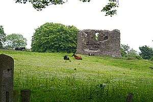 |
Cushendun 55°7′58.8″N 6°2′13.2″W / 55.133000°N 6.037000°W | Hall house | 14th Century | Little is known of this site, which may have been built in the 14th or 15th Centuries, though it is traditionally the place where Shane O'Neill was killed by the MacDonnells in 1567. Archaeological investigation suggests use of the abandoned building as a cillín (infant's' burial ground) in the 16th Century.[42] |
| Carrickfergus Castle |  |
Carrickfergus 54°42′46.8″N 5°48′2.16″W / 54.713000°N 5.8006000°W | Norman castle | 1188 | The tower and inner ward were built by John de Courcy, who led the Norman invasion of Ulster in the 12th Century. King John captured the castle for the English crown in 1210. It was held by Hugh de Lacy in the 13th Century, who set about construction of the outer walls and gatehouse. It later returned to the English crown, and was besieged several times. Improvements were made, in the 16th and 17th Centuries, in order to accommodate artillery. The castle was captured by the French in 1760 and afterward served as a military outpost, housing an armoury, magazine and prison. It was given into state care in 1928, and remains open to tourists as a historic monument.[43] |
| Dunaneeny Castle | Ballycastle 55°12′39.6″N 6°15′0″W / 55.211000°N 6.25000°W | Ruins | 1603 | Constructed by Sir Randall MacDonnell after 1600 on the site of a promontory fort, which had also been used as a base by English soldiers in the 1580s. The castle was built with sham defensive features, and excavation of the site indicated that it had never been a residence but was built for administration purposes. Only the foundations of the gatehouse are now visible, on the cliffs near a caravan park.[44] | |
| Dunluce Castle |  |
Portballintrae 55°12′39.6″N 6°34′44.4″W / 55.211000°N 6.579000°W | Castle | 13th Century | Built by the MacQuillans on the site of a 10th Century fort, the original castle dates from the 14th or 15th Century. The castle passed to the MacDonnells with the marriage of Colla MacDonnell and Evelyn MacQuillan in the 16th Century. Shane O'Neill captured Dunluce from Sorley Boy MacDonnell in 1565, and in 1584 it was besieged by Sir John Perrot who battered the castle with artillery. The castle was repaired by Sorley Boy's son Sir James, including construction of the Scottish-style gatehouse. In 1635 Randal MacDonnell, 2nd Earl of Antrim, built the hall for his wife, the Duchess of Buckingham, though she refused to live in the castle after part of it fell into the sea in 1639. The MacDonnells later moved to Glenarm Castle and Dunluce deteriorated. It was given into state care in 1928, and is open to the public.[45] |
| Dunseverick Castle |  |
Dunseverick 55°14′16.8″N 6°26′52.8″W / 55.238000°N 6.448000°W | Ruins | 9th Century | This coastal site was blessed by Saint Patrick and raided by Vikings in the 9th Century. By 1560 the castle was held by Sorley Boy MacDonnell, but was taken from him by Shane O'Neill that year. It was held by the O'Cahans in the 17th Century, but was destroyed by Cromwell's troops in the 1650s. Only the ruins of the gatehouse remain standing.[46] |
| Galgorm Castle | Ballymena 54°51′25.2″N 6°19′1.2″W / 54.857000°N 6.317000°W | Bawn and Country house | 17th Century | Galgorm Castle is a mid-17th Century country house, probably built for Dr Alexander Colville, within a bawn wall of the early 17th Century. It was renovated in the 1830s by the Earl Mount Cashell. It is a grade A listed building and remains a private residence.[47] | |
| Glenarm Castle |  |
Glenarm 54°57′57.6″N 5°57′21.6″W / 54.966000°N 5.956000°W | Country house | 1756 | Glenarm was the site of a medieval tower house, which was ruined by the mid 18th Century when Alexander MacDonnell, 5th Earl of Antrim, commissioned Christopher Myers to rebuild it as his principal residence. This was completed in 1756 in the Palladian style, and extended in the 1780s. In the 1820s, Anne, Countess of Antrim, commissioned Sir Richard and William Vitruvius Morrison to remodel the house and build the gatehouse in a "Jacobethan" style. The house was gutted by fire in 1929 and damaged by another fire in 1966, but was restored each time. It remains in the MacDonnell family and is a grade A listed building.[48] |
| Kinbane Castle |  |
Ballycastle 55°13′44.4″N 6°17′27.6″W / 55.229000°N 6.291000°W | Ruins | 1540s | Constructed by Colla MacDonnell on a coastal promontory, it was shortly after damaged by the cannons of the English under Sir James Croft in 1551. It was besieged again in 1555 and Colla died at the castle in 1558. In the 17th Century it was held by the MacAlisters, and was occupied into the 18th Century. The ruins came into state care in the 1970s, and comprise the remains of curtain wall and a ruined tower.[49] |
| Kilwaughter Castle | 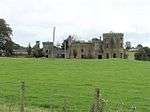 |
Larne 54°50′31.2″N 5°53′16.8″W / 54.842000°N 5.888000°W | Country house | 1807 | The present house was commissioned in 1807 by Edward Jones-Agnew to designs by John Nash. It was not completed until 1830, with further alterations continuing into the 1850s. It passed by marriage to an Italian family, and by 1939 it was owned by two sisters who lived in Italy. With the outbreak of the Second World War it was seized by the Custodian of Enemy Property, and used as a military training camp until 1945. The abandoned building was unroofed and stripped in the 1950s, and remains an empty shell. Investigation in the 1950s showed that it incorporates a 17th Century Scottish style tower house at its core.[50] |
| Lissanoure Castle | Loughguile 55°3′18″N 6°19′58.8″W / 55.05500°N 6.333000°W | A medieval castle stood at Loch Guile, which was replaced by the Macartneys in the 18th century. This was rebuilt in the 19th century but subsequently demolished. Only the estate buildings now remain, constructed using stone from the castle.[51] | |||
| Olderfleet Castle | .jpg) |
Larne 54°50′42″N 5°48′32.4″W / 54.84500°N 5.809000°W | Tower | 16th century | Probably built in the 16th century as a fortified storehouse and watchtower, overlooking the entrance to Larne Lough. This building was known as Coraine or The Curran. A separate structure formerly known as Olderfleete was located to the north-west, though nothing of this remains.[52] |
| Rathlin Castle or Bruce's Castle |  |
Rathlin Island 55°17′49.2″N 6°10′8.4″W / 55.297000°N 6.169000°W | Ruins | Limited remains of a medieval castle stand on a promontory on the island's east coast. It is said to have been the location where Robert the Bruce, King of Scots, stayed in 1306 after his flight from Scotland.[53] | |
| Red Bay Castle | Glenariff 55°4′1.2″N 6°3′18″W / 55.067000°N 6.05500°W | Ruins | 1563 | Sir James MacDonnell built a castle here in 1563, on the site of an earlier promontory fort. This was attacked and destroyed by Shane O'Neill two years later, but rebuilt by Sorley Boy MacDonnell in 1568. The site was robbed of stones for the repair of Dunluce Castle, but was restored in 1604. Cromwell's troops destroyed it once more in 1652 and only fragments of masonry remain above ground.[54] | |
| Shane's Castle | 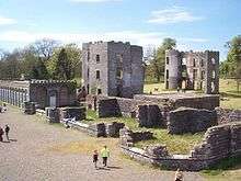 |
Randalstown 54°43′55.2″N 6°16′12″W / 54.732000°N 6.27000°W | Tower house and country house | 1345 | A series of buildings have stood on this site, a major seat of the O'Neills. A late medieval tower house forms the core of the complex, which was extended in the 17th century. This was replaced by a large country house in the 18th century. The Earl O'Neill commissioned John Nash to build a new extension in the early 19th century, but these were left unfinished when the main house burned down in 1816. The ruins of the various buildings are now in state care and open to the public.[55] |
| Castle Upton |  |
Templepatrick 54°42′14.4″N 6°5′27.6″W / 54.704000°N 6.091000°W | Country house | 1610 | Built as a tower house by Sir Robert Norton, it was sold in 1625 to Captain Henry Upton of Cornwall. His descendant John Upton, 1st Viscount Templetown, commissioned Robert Adam to remodel the house, extending it in a picturesque castellated style. The 2nd Viscount commissioned further remodelling by Edward Blore. The house was restored in the later 20th century and remains a private residence.[56] |
Armagh
| Name | Image | Location | Type | Date | Notes |
|---|---|---|---|---|---|
| Creevekeeran Castle | Keady 54°16′33.6″N 6°47′45.6″W / 54.276000°N 6.796000°W | Bawn | Creevekeeran was an impressive O'Neill Bawn with a moat built next to Hanslough Lake. Today, only one tower remains standing of the mighty Bawn.[57] | ||
| Fathom Castle | Newry | Bawn | 1550s | Fathom Castle, once a stronghold of the O'Neill clan, was built by Shane O'Neill.[58] Fathom castle was seized during the Nine Years' War and then demolished in 1730 for the construction of a canal. | |
| Gosford Castle |  |
Markethill 54°20′45.6″N 6°30′54″W / 54.346000°N 6.51500°W | Country house | 1850s | The Acheson family built a Plantation castle around 1617, though this was destroyed in the rebellion of 1641. It was replaced by a manor house which was occupied until around 1840. In 1819, Archibald Acheson, 2nd Earl of Gosford commissioned Thomas Hopper to design the present castle. The Norman-revival style castle was completed around 1859, though the family vacated it in the 1920s. It was sold to the Ministry of Agriculture in 1958, and was briefly a hotel in the 1980s. After a period of neglect it was sold on to developers in 2006, though the proposed residential renovation stalled in 2010.[59][60] |
| Killeavy Castle | Meigh 54°7′22.8″N 6°24′36″W / 54.123000°N 6.41000°W | Country house | 1836 | Originally a farmhouse called Killeavy Lodge, it was expanded by Newry banker Powell Foxall to create the present Gothic revival castle, designed by George Papworth. It was later owned by the Bell family but fell into disrepair in the later 20th century. It was sold in 2012 to owners wishing to restore the building.[61][62] | |
| Lurgan Castle or Brownlow House |  |
Lurgan 54°27′54″N 6°19′40.8″W / 54.46500°N 6.328000°W | Country house | 1833 | Brownlow House, known locally as 'Lurgan Castle', is a distinctive mansion built in 1833 with Scottish sandstone in an Elizabethan style with a lantern-shaped tower and prominent array of chimney pots. It was originally owned by the Brownlow family, and today is owned by the Lurgan Loyal Orange District Lodge. The adjacent Lurgan Park, now a public park owned by Craigavon Borough Council, used to be part of the same estate.[63] |
| Moyry Castle |  |
Jonesborough 54°4′12″N 6°23′6″W / 54.07000°N 6.38500°W | Bawn | 1601 | A small tower built by Charles Blount, one of the Queen's most ruthless and effective generals, during the Siege of Kinsale in 1601 to secure Moyry Pass and crush the power of the O'Neills in the Gap of the North.[64] |
| Tandragee Castle, or Tayto Castle.[65][66] |  |
Tandragee 54°21′14.4″N 6°25′1.2″W / 54.354000°N 6.417000°W | Country house | 1837 | In 332, the O'Hanlon clan built a fortress called Tonregue Castle here to help drive their foes from County Armagh, but that fortress was burned down by Irish rebels in 1641.[57] Nearly two hundred years later in 1837, Duke George Montagu built the current castle to serve as the residence of the Montagu family in Ireland. In the 1950s, the castle and estate were sold by Alexander Montagu to a business man from Tandragee by the name of Mr. Hutchison, and so the castle came to house the Tayto potato crisp factory and the park's demesne incorporates a golf course.[65] |
Down
| Name | Image | Location | Type | Date | Notes |
|---|---|---|---|---|---|
| Ardglass Castle | .JPG) |
Ardglass 54°15′30″N 5°36′20″W / 54.25833°N 5.60556°W | Country house | Late 18th Century | Built on top of the row of 15th Century warehouses that most of the other castles in Ardglas were built to protect, Ardglass Castle is a manor house built by Lord Charles Fitzgerald around 1790. Since 1911, it forms part of the Arglass Golf Club's course as the Club House.[67] Parts of the original structure, namely walls, still stand towards the east end of the property.[68] |
| Audley's Castle | 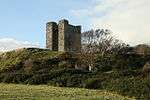 |
Strangford 54°22′44.4″N 5°34′22.8″W / 54.379000°N 5.573000°W | Bawn | 15th century[69] | Audley Castle is a 15th Century Bawn constructed by its namesake the Audleys on a rocky hill 1.6 kilometres (0.99 mi) from Strangford Lough.[70] In 1646, the tower passed into the keeping of the Wards of Castle Ward. In the 18th century the tower was incorporated into the parks of the Castle Ward estate. The tower remains standing though the bawn is largely ruined.[68] |
| Bagenal's Castle | .JPG) |
Newry 54°10′22.8″N 6°20′9.6″W / 54.173000°N 6.336000°W | Tower house | 16th century | English soldier Nicholas Bagenal built the tower house as his residence in around 1578, on the site of Newry's medieval abbey. It remained in his family until the 18th century, after which it was altered, and it became part of a bakery in 1894. The significance of the building was only noted in 1996 after the bakery closed; it has since been restored and now houses the Newry and Mourne Museum.[71][72] |
| Bangor Castle |  |
Bangor 54°39′21.6″N 5°40′8.4″W / 54.656000°N 5.669000°W | Country house | 1848 | Robert Edward Ward had the house constructed in 1848 to replace a 17th-century building on the site. The architect was probably William Burn, with Anthony Salvin having designed the separate stables building. It was the home of Lord Clanmorris in the early 20th century, and on the death of his widow in 1941 the estate was bought by Bangor Council. The house has served as Bangor Town Hall since 1952.[73] |
| Bright Castle | 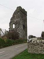 |
Downpatrick 54°16′30″N 5°41′16.8″W / 54.27500°N 5.688000°W | Tower house | 15th or 16th Centuries | Built in the late 15th or early 16th century, the castle may have been demolished by Lord Grey in 1538. Only the eastern half now remains standing.[74] |
| Carrowdore Castle |  |
Donaghadee 54°34′51.6″N 5°32′34.8″W / 54.581000°N 5.543000°W | |||
| Castlewellan Castle |  |
Castlewellan 54°15′50.4″N 5°57′18″W / 54.264000°N 5.95500°W | Country house | 1856-1858 | A Scottish baronial castle built by the Annesley family between 1856 and 1858. It is located in Castlewellan Forest Park and is now used as a Christian conference centre.[75][76][77] |
| Clough Castle | %2C_October_2009.JPG) |
Clough 54°17′24″N 5°49′55.2″W / 54.29000°N 5.832000°W | Motte-and-bailey | Late 12th Century | A small motte and bailey castle built by an important Norman knight in the late 12th Century following the Norman Invasion of Ireland in timber and earth with some stone.[78] Though it has fallen into ruin, Clough castle is today one of the best preserved examples of a Motte and Bailey in Ireland. |
| Cowd Castle or "Choud Castle" |  |
Ardglass 54°15′29.52″N 5°36′20.52″W / 54.2582000°N 5.6057000°W | Bawn | 15th or 16th Centuries | Located across the street from Margaret castles stands Cowd castle, a small two-story tower house built in either the late 15th or early 16th Centuries as part of a larger structure built with the intention of protecting the local area and its trade.[79] In 1791, Lord Charles Fitzgerald demolished much of that structure castle for his mansion, Ardglass Castle. |
| Dundrum Castle | .jpg) |
Dundrum 54°15′46.8″N 5°50′45.6″W / 54.263000°N 5.846000°W | Castle | Early 13th Century[80] | Dundrum Castle (not to be confused with Dublin's Dundrum Castle) was built by John de Courcy after his invasion of Ulster to control access to Lecale from the west and the south. It was built upon a tall, rocky hill and thus commands fine views of the Dundrum Bay and Mourne Mountains, and the lands west towards Slieve Croob and the plains of Lecale to the east. Dundrum castle has undergone several modifications such as the round keep added by King John, its current lopsided design from Hugh de Lacy's second term as Earl of Ulster, and the Outer bailey that was built by the Magennis family in the late 15th Century.[81] The castle was demolished in 1652. Dundrum is a Scheduled monument. |
| Greencastle |  |
Kilkeel 54°2′27.6″N 6°5′49.2″W / 54.041000°N 6.097000°W | Castle | C. 1230[82] | Greencastle is a 15 and 16th Century castle built on the site of a Motte-and-bailey possibly built by Hugh de Lacy in the 13th Century. Local folklore also has it that John de Courcy was married here.[83] The castle served as an English garrison in Northern Ireland for several hundred years before Cromwellian soldiers subjected to artillery fire to prevent its usage by Irish rebels. |
| Hillsborough Castle |  |
Hillsborough 54°27′39.6″N 6°5′9.6″W / 54.461000°N 6.086000°W | Georgian Country house | 1770s | A Georgian manor house owned the Queen that served as the resident of the Governor of Northern Ireland until 1973 and now serves as the official residence of the Secretary of State for Northern Ireland as well as the official residence of the Queen in Northern Ireland.[84][85] Hillsborough Castle and the (at that time) village of Hillsborough were constructed in the 1770s Wills Hill,[86] the first Marquess of Downshire, for the Hill family and was in the keeping of the Hill family until 1922.[87] |
| Jordan's Castle |  |
Ardglass 54°15′36″N 5°36′32.4″W / 54.26000°N 5.609000°W | Tower house | 15th Century | Jordan's Castle is a rectangular, four story tall tower house in Ardgrass, County Down.[79] Built by Simon Jordan to defend against the Tyrone Rebellion for three years until he was relieved by Baron Charles Bluont in 1601.[88] In 1911, Belfast antiquarian Francis Joseph Bigger bought the castle, restored it and used it to display his extensive collection of antiquities and made it freely accessible to everyone to bring local people "in touch with the Irish past, and give them some conception of the historic background of their life."[89] |
| King's Castle | .JPG) |
Ardglass 54°15′32.4″N 5°36′28.8″W / 54.259000°N 5.608000°W | Tower house | 12th Century | Easily the largest medieval structure in Ardglass,[88] King's Castle is a tower house originally built in the 12th Century and modified extensively in following centuries. Was rebuilt in the 19th Century and reopened as a nursing home, which it remains even today, following a collapse of the building in 1830 after failed attempts to repair the foundation of the building. |
| Kilclief Castle |  |
Strangford 54°19′40.8″N 5°33′14.4″W / 54.328000°N 5.554000°W | Tower house | 1412-1441 | The oldest known tower in Lecale, having been erected in the window of time from 1412 to 1441 and probably by John Sely, Bishop of Down,[90] Kilclief Castle is very similar in construction to Jordan's Castle and is notably less ruined. Later, the building was garrisoned by 11 English soldiers during the Irish Nine Years' war from 1601 to 1602. |
| Killyleagh Castle |  |
Killyleagh 54°24′7.2″N 5°39′14.4″W / 54.402000°N 5.654000°W | Castle | 1180 | In its current presentation, Killyleagh Castle is as architect Sir Charles Lanyon designed it: a Loire Valley style château built in the mid 18th Century. Possibly one of the oldest continuously inhabited castles in Ireland, Killyleagh Castle was first constructed by Norman knight John de Courcy in 1180,[91] one of many such fortifications to protect the Strangford Lough against Viking incursion.[92] Since its early beginnings, the castle has been important to the history of the local region (County Down), having a pivotal role to play in events from local lords in the Dark Ages fighting against English rule (and subsequently being quashed),[93] local fighting against the English connected to the fall of the Stuarts, and even local combat against the Irish Republican Army in the 1920s.[92] |
| Kirkistown Castle |  |
Cloghy 54°26′31.2″N 5°27′57.6″W / 54.442000°N 5.466000°W | Bawn | 1622 | A three story tall tower house and Bawn built by Roland Savage, a Norman landlord,[94] on the site of a 9th Century tower in 1622 (thus predating the Plantation). The tower was occupied until it was abandoned and left to decay until its purchase and Gothic renovation by a "Colonel Johnston" and some further modification still in 1836 by a "Montgomery of Grey Abbey." It was abandoned once again in 1831,[95] but was opened to the public once more in 2001 by the Northern Ireland Environment Agency. |
| Mahee or Nendrum Castle |  |
Strangford Lough 54°30′3.6″N 5°38′52.8″W / 54.501000°N 5.648000°W | Tower house | 1570 | Is a ruined tower house near Nendrum Monastery on Mahee Isle by an English soldier named Captain Thomas Browne.[96][97] Later, it fell into ruin after being abandoned in the early 17th Century until its partial renovation in 1923 by H.C. Lawlor and the Belfast Natural History and Philosophical Society.[98] |
| Margaret's Castle | .JPG) |
Ardglass 54°15′30.24″N 5°36′23.04″W / 54.2584000°N 5.6064000°W | Tower house | 15th Century (est.) | Margaret's Tower is one of six ruined tower houses built to protect the warehouses that used to stand in Ardglass that possibly stood 3 stories tall and is thought to have been built in the 15th Century. |
| Myra Castle | Strangford 54°22′4.8″N 5°37′19.2″W / 54.368000°N 5.622000°W | ||||
| Narrow Water Castle |  |
Warrenpoint 54°6′54″N 6°16′58.8″W / 54.11500°N 6.283000°W | Bawn | 1212, 1560s | A famous Bawn constructed some time in the 1560s on the site of an old Norman keep built by the first Earl of Ulster Hugh de Lacy in 1212 in order to impede attacks on the river city of Newry. Narrow Water Castle was also the site of the infamous Warrenpoint ambush on 27 August 1979, wherein the Provisional Irish Republican Army detonated two bombs, killing 18 English army soldiers.[99] |
| Portaferry Castle | .jpg) |
Portaferry 54°22′48″N 5°32′56.4″W / 54.38000°N 5.549000°W | Tower house | 16th Century | A small tower house built by William Le Savage in the 16th Century overlooking the harbor.[100] It has seen little to no change in its form over the years. |
| Quintin Castle |  |
Portaferry 54°22′37.2″N 5°29′20.4″W / 54.377000°N 5.489000°W | Norman Castle | 1184 | Quintin castle is one of the very few Anglo-Norman castles still occupied in Ireland.[101] The castle was built in 1184 on the orders of John de Courcy and later occupied by the Savage family, who would add some small additions to the castle. This cycle would continue through the ages all the way to now. |
| Quoile Castle |  |
Downpatrick 54°20′56.4″N 5°41′56.4″W / 54.349000°N 5.699000°W | Tower house | Late 16th Century | Another small tower house located 1.5 miles (2.4 km) from Downpatrick on the east bank of the River Quoile that was inhabited into the late 18th Century.[102] |
| Sketrick Castle |  |
Whiterock 54°29′16.8″N 5°38′52.8″W / 54.488000°N 5.648000°W | Tower house | 12th century | A tower house on Sketrick Island near Whiterock thought to have built in the 12th Century that was acquired by Sir Robert Savage in the 14th Century.[103] The Annals of the Four Masters record the capture and turning over of the castle in 1470 by an army led by the O'Neills to MacQuillans.[104] It was intact until 1896 when a storm demolished much of it.[105] |
| Stormont Castle |  |
Belfast 54°36′7.2″N 5°49′48″W / 54.602000°N 5.83000°W | Mansion | Mid 19th Century | Stormont, a Scottish baronial mansion built in the mid 19th Century, is one of the primary governmental buildings in Northern Ireland. Stormont has been the official residence for those Prime Ministers of Northern Ireland who didn't instead decide to live in Stormont House and the location of the Cabinet Room of the Government of Northern Ireland from 1921 to 1972. Before devolution it was the Belfast headquarters of the Secretary of State for Northern Ireland, Northern Ireland Office Ministers and their supporting officials. During the Troubles, it was also used by MI5 officers.[106] |
| Strangford Castle |  |
Strangford 54°22′19.2″N 5°33′18″W / 54.372000°N 5.55500°W | Tower house | 15-16th Century | An intact tower house built on a hill overlooking the town of Strangford.[107] Although almost all of the castle corresponds with 16th Century Irish architecture, the tower house's door seems to indicate that the current incarnation of the tower is simply a remodelling of an earlier 15th Century tower house. Strangford was used as a set for Winterhold in the popular HBO TV series, Game of Thrones. |
| Walshestown Castle |  |
Strangford 54°22′22.8″N 5°37′22.8″W / 54.373000°N 5.623000°W | Tower house | ||
| Castle Ward |  |
Strangford 54°22′22.8″N 5°34′44.4″W / 54.373000°N 5.579000°W | Tower house | 1760s[108] | An 18th-century National Trust property located 1.5 miles (2.4 km) from the village of Strangford that overlooks the Strangford Lough. The castle has been the home of the Ward family since about 1570, though the modern structure was built for Bernard Ward by an unknown architect, possibly and individual with ties to the Wards or James Bridges.[109] On 10 February 1973, Leonard O'Hanlon (age 23) and Vivienne Fitzsimmons (age 17), both members of the Provisional Irish Republican Army, were killed in a premature bomb explosion in the grounds of Castle Ward estate.[110][111] |
Fermanagh
| Name | Image | Location | Type | Date | Notes |
|---|---|---|---|---|---|
| Castle Archdale |  |
Irvinestown 54°29′13.2″N 7°42′43.2″W / 54.487000°N 7.712000°W | Bawn | 1615 | John Archdale built the tower house and bawn in 1615 during the Plantation of Ulster. During the Irish Rebellion of 1641 it was destroyed by Rory Maguire but subsequently rebuilt. During the Irish campaign of the Nine Years' War, Archdale Castle was destroyed again in 1689. A mansion, also known as Castle Archdale, was built on the estate in 1778, though this was also demolished. Of the final mansion built on this grounds, only the cobblestone courtyard remains because said mansion collapsed in 1883.[112] During World War Two, Castle Archdale was an RAF airbase. The ruins are today within a country park.[113] |
| Belle Isle Castle | Lisbellaw 54°16′1.2″N 7°33′21.6″W / 54.267000°N 7.556000°W | Country house | 1700 | Belle Isle Castle is in truth a large estate spread across eight islands that has been inhabited since the 12th Century.[114] Though the castle has been privately owned for nearly its entire history by generations of nobles such as Ralph Gore, 1st Earl of Ross,[115] it has been open to the public since 1760, when the castle began hosting ceremonies, primarily marriages.[115] Belle Isle was built by the aforementioned Ralph Gore around 1700 after his father, Paul Gore acquired ownership of the islands and has seen much expansion since. Today, the Duke of Abercorn owns and operates the castle as a venue and accommodation and has been declared a Special Area of Conservation.[116][117] | |
| Castle Balfour |  |
Lisnaskea 54°15′3.6″N 7°26′42″W / 54.251000°N 7.44500°W | Castle | 1619 | Although Castle Balfour is a ruin, it is one of the best-preserved of Plantation-era castles.[118] Castle Balfour (also known as Castle Skeagh) was erected in 1619 by Lord Michael Balfour when the land was granted to him by King James I.[119][120] The castle was altered in 1652 and damaged in 1689.[121] The last person to possess and inhabit the Castle was James Haire (1737-1833) who leased the castle from Earl Erne. The Haire family ceased to live in the castle when it was razed by an unknown arsonist. Major conservation and restoration was undertaken in the 1960s and further conservation work was completed in the late 1990s.[121] Recent Radiocarbon on a ringfort that belonged to the Macguires (the primary suspects in the above arson) on the grounds of the castle date back to 359-428 AD.[122] |
| Castle Caldwell |  |
Belleek 54°29′27.6″N 7°58′26.4″W / 54.491000°N 7.974000°W | Bawn | 1613 | Francis Blennerhassett built a tower house and bawn before 1620, which was sold to Enniskillen merchant James Caldwell in 1660. In the 1780s it was extensively remodelled and enlarged to form a country house in the Gothic style. It was abandoned in the late 19th Century, and in 1913 the Forest Service purchased the estate. The ruins remain standing within the forest.[123] |
| Castle Coole |  |
Enniskillen 54°20′9.6″N 7°36′10.8″W / 54.336000°N 7.603000°W | Country house | 1798 | A mansion built on the site of a 17th Century Bawn named after a nearby lake, Lough Coole. Earlier structures in the area include a ráth and a crannog on the lake.[124] Today's Castle Coole was constructed from 1789 and 1798 as the summer retreat of Armar Lowry-Corry, 1st Earl of Belmore and a showpiece by architect James Wyatt. Additionally, several smaller family residences had been built on the Castle Coole estate preceding the mansion, including a dwelling of the King James period (later deliberately destroyed by arson) and a Queen Anne style house built in 1709. The house is now managed by the National Trust and is open to the public.[125] |
| Crevenish Castle | Kesh 54°30′39.6″N 7°44′42″W / 54.511000°N 7.74500°W | Bawn | c. 1618 | Crevenish Castle is a ruined Bawn located 3 miles (4.8 km) southwest of the village of Kesh. The bawn was built by a Norfolk man named Thomas Blennerhassett (whose brother built Caldwell Castle),[126] a former captain at Cornet Castle on the Isle of Guernsey, between 1611 and 1622. The castle fell into the hands of the local Macguires when Thomas's eldest son died and his wife wed Rory O'Moore, leader of the Irish Rebellion of 1641, bur returned to the Blennerhassetts when Rory was killed in 1648. The castle was reported as being in "ruinous" condition by 1697.[127] Around a third of the structure still stands in a caravan albeit private park.[128] | |
| Crom Castle |  |
Newtownbutler 54°10′4.8″N 7°26′52.8″W / 54.168000°N 7.448000°W | Country house | 1838 | Crom Castle is a 19th Century Victorian style castle situated on the coast of the Upper Lough Erne. The castle was commissioned by John Crichton, 3rd Earl Erne in 1831,[129] and designed and executed by architect Edward Blore (who was responsible for sections of Buckingham Palace)[130] in the baronial and Neo-Tudor styles.[130] The mansion was completed seven years later, only to burn down three years later. Since its complete reconstruction, it has remained the home of the Earl of Erne.[131] |
| Old Crom Castle |  |
Newtownbutler 54°9′43.2″N 7°26′38.4″W / 54.162000°N 7.444000°W | Plantation castle and bawn | 1619 | Like a lot of Irish country houses in the 17th Century, an English lord, in this case Michael Balfour, was granted this lake-shore estate in 1611 during the Plantation of Ulster. The estate would pass into the keeping of the Crichton family in 1655,[132] which by then included Balfour's Bawn, which went on to survive two sieges in the Williamite War before being destroyed in a fire in 1746.[132] It was remodelled as a romantic garden in the 19th century, after the 'new' Crom Castle was built. The old castle and parks are now owned by the National Trust.[133][134] |
| Enniskillen Castle |  |
Enniskillen 54°20′45.6″N 7°38′38.4″W / 54.346000°N 7.644000°W | Tower house, later a barracks | 15th century | The castle keep was established on a strategic site in the early 15th century by Hugh the Hospitable of the Maguire family. It was attacked by the O'Donnells and O'Neills in the 16th century, and taken for the British crown in 1594. Although recaptured by the Maguires, they destroyed most of the castle in 1602 to deny it to the British. During the Plantation of Ulster Sir William Cole was appointed constable of Enniskillen, charged with rebuilding the castle. From 1607 he rebuilt the tower and constructed the Water Gate. The castle was besieged by the Irish in 1641. The site was extensively rebuilt as a barracks in the later 18th century, and was occupied by the army until 1950. It is now in state care and has been open to the public since 1964, currently housing the County Museum.[135][136] |
| Monea Castle |  |
Monea 54°23′34.8″N 7°44′52.8″W / 54.393000°N 7.748000°W | Bawn | 1618 | The Scots-influenced tower house was built by Malcolm Hamilton, who added the bawn in the 1620s. It was besieged and captured during the Irish Rebellion of 1641. After 1688 it was the residence of Gustavus Hamilton, Governor of Enniskillen, but was abandoned following a fire in the 18th century. The ruins are in state care and open to the public.[137] |
| Necarne Castle (Castle Irvine) | _%2C_Irvinestown_-_geograph.org.uk_-_357778.jpg) |
Irvinestown 54°27′50.4″N 7°38′6″W / 54.464000°N 7.63500°W | Country house | 1615 | A tower house and bawn were built by Gerald Lowther in the Plantation period. The lands passed to the Irvine family later in the 17th century, and in 1833 the castle was rebuilt with a new Tudor-Gothic south wing. It has been empty since being used as a military hospital in the Second World War.[138] |
| Portora Castle |  |
Enniskillen 54°21′18″N 7°39′39.6″W / 54.35500°N 7.661000°W | Bawn | 1614 | A tower house and bawn built by Sir William Cole, it was let to James Spottiswood, Bishop of Clogher, in the 1620s, and was besieged in 1641 and 1688. The tower was occupied by the Coles until 1764, after which it decayed. It was partly destroyed in an explosion in 1859, and further collapsed during gales in the late 19th century.[139] |
| Tully Castle |  |
Blaney 54°27′21.6″N 7°48′21.6″W / 54.456000°N 7.806000°W | Bawn | 1618 | Built for Sir John Hume, Tully comprised a tower house within a courtyard, which had square towers at each corner. The house was burned down by Rory Maguire during the Irish Rebellion of 1641, and was not subsequently reoccupied. A 17th-century style garden has been created in the courtyard.[140][141] |
Londonderry
| Name | Image | Location | Type | Date | Notes |
|---|---|---|---|---|---|
| Bellaghy Castle | 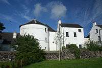 |
Bellaghy 54°48′28.8″N 6°31′8.4″W / 54.808000°N 6.519000°W | Bawn | 1619 | A Bawn that became a fortified house built during the Plantation of Ulster on the site of an old ringfort in 1619.[142] |
| Coleraine Castle | Coleraine 55°7′55.2″N 6°40′37.2″W / 55.132000°N 6.677000°W | Motte and bailey | 1248 | Norman-era castle, built on the site of a monastery and replaced with an 18th-century manor house.[143] | |
| Dungiven Castle |  |
Dungiven 54°55′30″N 6°55′15.6″W / 54.92500°N 6.921000°W | Country house | 1839 | An earlier house was built on this site in the late 17th century. This was replaced by Robert Ogilby who constructed the present Gothic-revival castle in the 1830s, although it remained incomplete on his death in 1839. It was later converted into flats and then bought by the local authority, who proposed demolition in the 1980s. It has since been restored and is now a hotel.[144][145] |
| Limavady Castle or O'Cahans Castle | Limavady 55°1′26.4″N 6°56′16.8″W / 55.024000°N 6.938000°W | Tower house | 15th century | A stronghold of the O'Cahans, the tower house by the River Roe may have been built here in the late 15th century. A siege by the MacQuillans is recorded in 1542. The castle was demolished in the 1820s.[146] | |
| Low Rock Castle |  |
Portstewart 55°10′40.8″N 6°43′26.4″W / 55.178000°N 6.724000°W | Country house | 1820 | Late-Georgian castellated villa, once the home of Field Marshal Sir George White (1835–1912). It was demolished in 2001.[147] |
Tyrone
| Name | Image | Location | Type | Date | Notes |
|---|---|---|---|---|---|
| Altinaghree Castle, Ogilby's Castle |  |
Donemana 54°52′48″N 7°14′45.6″W / 54.88000°N 7.246000°W | Mansion | 1860 | A derelict castle outside of Donemama, County Tyrone alleged to have been built by William Ogilby in 1860.[148][149] William's son James fell in love with a factory seamstress, Mary Jane Jamieson, whom he ended up eloping and marrying in 1884. The castle was abandoned by the end of the century and fell into disrepair.[150][151] |
| Augher Castle |  |
Augher 54°25′44.4″N 7°8′9.6″W / 54.429000°N 7.136000°W | Country house | 1615 | A typical, 30 feet (9.1 m) tall Plantation era castle built by Lord Ridgeway in 1615 on the site of an older fortification that was later razed in 1689 by Jacobite forces during the Siege of Derry.[152] The castle was rebuilt and then graced by an adjoining mansion by architect Sir J. M. Richardson Bunbury, Bart in 1832 and used by the Richardson-Bunbury baronets as their seat. |
| Benburb Castle | Benburb 54°24′28.8″N 6°44′42″W / 54.408000°N 6.74500°W | Bawn | 1611 | An irregular four sided Plantation-era Bawn built in 1611 by Sir Richard Wingfield on a limestone cliff overlooking the River Blackwater, the border of Counties Tyrone and Armagh.[153] As Wingfield had no desire to live at Benburb Castle, the castle was no main residential structure making it something of a defensive structure resembling a keep rather than a residence such as a Bawn. 30 years after its completion, the castle was taken by Phelim O'Neill and everyone in the castle was slain.[154] Although the castle was dismantled in 1640,[153] it was restored and is today used as a priory and conference center by the Servite Order.[154] | |
| Castlederg Castle, or Derg Castle |  |
Castlederg 54°42′21.6″N 7°35′52.8″W / 54.706000°N 7.598000°W | Bawn | 1610 | The ruins of a rectangular Plantation-era Bawn built on the ruins of earlier O'Neill tower house located on the north shore of the River Derg.[155][156][157] The exact date of the castle's construction is unknown, but it was first mentioned in 1497 by the Annals of the Four Masters.[158][159] What is known, however, is that the castle was rebuilt in 1610 by Sir John Davies, who settled his purchased plot of land with 16 families brought over from England and also founded the town of Castlederg.[160] Phelim O'Neill, in his 1641 Rebellion, besieged Castleerg and took it in his ultimately unsuccessful attempt to drive the newcomers from Ulster, and the castle was dismantled.[156][160] After the besieging and surrender of the castle to King James II's forces during the Williamite Wars in Ireland, the castle fell into disuse and ruin.[158] |
| Caulfield Castle |  |
Castlecaulfield 54°30′21.6″N 6°50′6″W / 54.506000°N 6.83500°W | Fortified house | 1614[161] | Castle Caulfield is a ruined Plantation-era fortified house built by Sir Toby Caulfield upon the ruins of an older O'Donnelly castle (dendrochronology of a joist present in the structure date back to 1282).[162][163] The second Lord Charlemont added a keep or donjon, and a large gatehouse with towers to the castl.[164] The castle was burned down in the Irish Rebellion of 1641 by Patrick Donnelly,[165] was rebuilt and occupied by the Caulfields again in 1660s, only for the castle to fall into ruin again around 1700.[165] Today, the castle is a State Care Historic Monument.[166] |
| Dungannon Castle | Dungannon 54°30′0″N 6°46′12″W / 54.50000°N 6.77000°W | Ruin | 1305 | Since 1305, the ancestral castle of the O'Neill dynasty stood on this hill outside of Dungannon.[167] However, that castle was razed in 1602 by Hugh O'Neill to prevent the capture of the town and castle by the English. When the Plantation of Ulster began, the land the castle stood on was granted to Sir Arthur Chichester, who rebuilt it.[168] In the again O'Neill led Irish Rebellion of 1641, the castle was undermined and seized by Felim O'Neill, where he and his rebels declared their loyalty to Charles I. | |
| Harry Avery's Castle |  |
Newtownstewart 54°42′46.8″N 7°23′34.8″W / 54.713000°N 7.393000°W | Castle | 1320 | A rare example of a Gaelic castle left in Northern Ireland that is thought to have been built in 1320 by a local O'Neill chieftain named Henry Aimhréidh O'Neill (d. 1392),[169][170] or Harry Avery O'Neill.[171] Despite that, it seems to have been a site of low importance to the local Gaelic people. The castle was seized by the ENglish in 1609 and used as a quarry].[170] Today, the castle's ruins are a State Care Monument under the guardianship of the Northern Ireland Environment Agency.[172] |
| Killymoon Castle | Cookstown 54°38′6″N 6°44′9.6″W / 54.63500°N 6.736000°W | Country house | 1803 | Two castles have stood on this site. The first was a castle built in 1761 by James Stewart, which burned down in 1801. The second and notably larger structure is the castle built by Col. William Stewart in the Neo-Gothic style circa 1803 according to a design by architect John Nash.[173][174][175] Today, the castle estate is home to a modest, 18-hole golf course.[176] | |
| Mountjoy Castle |  |
Brockagh 54°33′32.4″N 6°36′28.8″W / 54.559000°N 6.608000°W | Bawn | 1602[177] | Mountjoy Castle was a campaign fort built with red bricks by Lord Mountjoy in 1602 upon the ruins of an O'Neill fortress named "Fuath na nGall" (Irish: Hatred of Foreigners).[178] During the Rebellion of 1641, the castle was taken by Turlough O'Neill and used as his personal fortress until his total defeat two years later. In 1648, the castle was dismantled on the orders of Parliament and was left in ruin. The castle is today a State Care Historic Monument and freely accessible to the public.[166] |
| Roughan Castle | 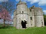 |
Newmills 54°34′22.8″N 6°45′7.2″W / 54.573000°N 6.752000°W | Bawn | 1618 | A State Care Historic Monument located near Newmills, Northern Ireland.[179] Roughan Castle is a Plantation-era castle built by Sir Andrew Stewart, the Second Lord Castlestewart. During the Rebellion of 1641, the castle's current lord, Robert Stewart, was appointed a commander in the Rebel armies by Phelim O'Neill and he was captured here and brought to Dublin to be executed.[180][181][182] |
| Roxborough Castle |  |
Moy 54°26′49.2″N 6°41′31.2″W / 54.447000°N 6.692000°W | Country house | 1738[183] | The castle, originally built in 1738 as the seat of the Earl of Charlemont,[184] was remodeled by architect William Murray in the Italianate style in 1842 for the second Viscount of Charlemont. Further remodeling later by the Second Viscount's resulted in a house that resembled a French château. The castle was again renovated in 1864 by the Third Viscount before the castle was razed to the ground by the Irish Republican Army in 1922.[185] |
| Stewart Castle |  |
Newtownstewart 54°43′8.4″N 7°22′30″W / 54.719000°N 7.37500°W | Bawn | 1619 | An Plantation-era English manor built in 1619 by Sir Robert Newcomen following the Flight of the Earls.[186] The castle was razed twice - first during the 1641 Rebellion by Sir Felim O'Neill, and again in 1689 by King James II along with its town as he returned from the Siege of Derry.[187] Today, the monument is a State Care Historic Monument.[166] Also present on the site is an intact Bronze Age cist that was excavated in 1999.[188] |
See also
- Abbeys, priories and historic houses
- Castles
- History of Ireland
- List of country estates in Northern Ireland
- List of castles in the Republic of Ireland
- List of abbeys and priories in Northern Ireland
- List of abbeys and priories in the Republic of Ireland
References
Notes
- ↑ "Ballyloughan Castle". carlowtourism.com/. Carlow Tourism.
- ↑ "Ballyloughan Castle". britainirelandcastles.com. Britain-Ireland-Castles.
- ↑ "Ballyloughan Castle". megalithicireland.com. Megalithic Ireland.
- 1 2 "Ballyloughan Castle". discoverireland.ie. Discover Ireland.ie.
- 1 2 "Ballymoon Castle". megalithicireland.com. Megalithic Ireland.
- ↑ "Ballymoon Castle". historic-ireland.com. Historic Ireland.
- 1 2 "Carlow Castle". rootsweb.ancestry.com. Ancestry.
- 1 2 "Carlow Castle". discoverireland.com. Discover Ireland.
- 1 2 "Carlow Castle". britainirelandcastles.com. Britain - Ireland - Castle.
- ↑ "Carlow Castle". carlowtourism.com. Carlow Tourism.
- ↑ "Carlow Castle". askaboutireland.com. Ask about Ireland.
- ↑ "Huntington Castle". carlowtourism.com. Carlow Tourism.
- ↑ "Family History of Huntington Castle". huntingtoncastle.com. Huntington Castle and Gardens.
- ↑ "Huntington Castle - Ghostly Tales and Worthy Fellowships". turtlebunbury.com/index.html. Turtle Bunbury.
- ↑ "Leighlinbridge Castle". South East Ireland.com. Retrieved 2007-12-10.
- ↑ "Leighlinbridge Castle". Archived from the original on March 11, 2005. Retrieved 2007-12-10.
- ↑ "The Black Castle Leighlinbridge". megalithicireland.com. Megalithic Ireland.
- ↑ "Leighlinbridge Castle". An Ireland Attraction.
- ↑ "Tinnahinch". rootsweb.ancestry.com. Ancestry.
- ↑ "Tinnahinch Castle". discoverireland.ie. Discover Ireland.
- ↑ "Tinnahinch Castle". barrowriver.ie. Barrow River.
- 1 2 "Castles in Ireland - County Cavan". rootsweb.ancestry.com. Ancestry.
- ↑ "Ballyconnell Houe". buildingsofireland.com. Buildings of Ireland.
- ↑ "The History of Cabra Castle". cabracastle.com. Cabra Castle.
- 1 2 Ferres, Timothy. "Castle Saunderson". lordbelmontinireland.com. Lord Belmont in Ireland.
- ↑ "Clough Oughter Castle". discoveringireland.com. Discovering Ireland.
- ↑ "Cloughoughter Castle, County Cavan". irelandseye.com.
- ↑ "Clough Oughter Castle Cavan". discoverbelturbet.ie. Discover Belturbet.
- ↑ "Clough Oughter Castle". britainirelandcastles.com. Britain - Ireland - Castles.
- ↑ Photographs of Castledonovan Castle undergoing restoration by Mike Searle (2007)
- ↑ Castle Harrison
- ↑ "Ballybur Castle Website". Ballyburcastle.com. Retrieved 2011-11-22.
- ↑ Antrim Castle, Library Ireland
- ↑ "Antrim Castle". Northern Ireland Sites and Monuments Record. Northern Ireland Environment Agency. Retrieved 20 May 2015.
- ↑ "Antrim Castle, Co. Antrim". Archiseek. Retrieved 20 May 2015.
- ↑ "Antrim Castle spooky visit". Discover Ireland. Retrieved 29 May 2011.
- ↑ "Bally Castle". Northern Ireland Sites and Monuments Record. Northern Ireland Environment Agency. Retrieved 27 May 2015.
- ↑ "Ballygally Castle". Northern Ireland Buildings Database. Northern Ireland Environment Agency. Retrieved 27 May 2015.
- ↑ "Haunted Ulster". BBC. Retrieved 28 May 2011.
- ↑ "Ballylough Castle". Northern Ireland Sites and Monuments Record. Northern Ireland Environment Agency. Retrieved 27 May 2015.
- ↑ "Belfast Castle". Northern Ireland Buildings Database. Northern Ireland Environment Agency. Retrieved 27 May 2015.
- ↑ "Castle Carra". Northern Ireland Sites and Monuments Record. Northern Ireland Environment Agency. Retrieved 27 May 2015.
- ↑ "Carrickfergus Castle". Northern Ireland Sites and Monuments Record. Northern Ireland Environment Agency. Retrieved 27 May 2015.
- ↑ "Dunineny Castle". Northern Ireland Sites and Monuments Record. Northern Ireland Environment Agency. Retrieved 28 May 2015.
- ↑ "Dunluce Castle". Northern Ireland Sites and Monuments Record. Northern Ireland Environment Agency. Retrieved 28 May 2015.
- ↑ "Dunseverick Castle". Northern Ireland Sites and Monuments Record. Northern Ireland Environment Agency. Retrieved 28 May 2015.
- ↑ "Galgorm Castle". Northern Ireland Sites and Monuments Record. Northern Ireland Environment Agency. Retrieved 28 May 2015.
- ↑ "Glenarm Castle". Northern Ireland Buildings Database. Northern Ireland Environment Agency. Retrieved 28 May 2015.
- ↑ "Kinbane Castle". Northern Ireland Sites and Monuments Record. Northern Ireland Environment Agency. Retrieved 29 May 2015.
- ↑ "Kilwaughter Castle". Northern Ireland Buildings Database. Northern Ireland Environment Agency. Retrieved 29 May 2015.
- ↑ "Lisanoure Castle". Northern Ireland Sites and Monuments Record. Northern Ireland Environment Agency. Retrieved 29 May 2015.
- ↑ "Olderfleet Castle". Northern Ireland Sites and Monuments Record. Northern Ireland Environment Agency. Retrieved 29 May 2015.
- ↑ "Bruce's Castle". Northern Ireland Sites and Monuments Record. Northern Ireland Environment Agency. Retrieved 29 May 2015.
- ↑ "Red Bay Castle". Northern Ireland Sites and Monuments Record. Northern Ireland Environment Agency. Retrieved 29 May 2015.
- ↑ "Shane's Castle ruins". Northern Ireland Buildings Database. Northern Ireland Environment Agency. Retrieved 29 May 2015.
- ↑ "Castle Upton". Northern Ireland Buildings Database. Northern Ireland Environment Agency. Retrieved 27 May 2015.
- 1 2 Castles of Ireland, Armagh County
- ↑ Shane O'Neill's Campaigns
- ↑ "Gosford Castle, Co. Armagh". Queens University Belfast. Retrieved 20 May 2015.
- ↑ "Financially besieged developer behind apartments plan at historic pile loses battle to builders over £80k bill". Belfast Telegraph. 31 January 2013.
- ↑ "Killevy Castle". Northern Ireland Buildings Database. Northern Ireland Environment Agency. Retrieved 21 May 2015.
- ↑ "Killeavy Castle in south Armagh gets a new owner". BBC News. 13 March 2013.
- ↑ Brownlow House – History. Brownlow House. Retrieved 2010-02-25
- ↑ History of Moyry Castle, Ring of Gullion
- 1 2 york.ac.uk, UK Buildings Database
- ↑ "Tayto - History". The Tayto Group. Retrieved 27 Jan 2016.
- ↑ Bence-Jones, Mark (1988). A Guide to Irish County Houses. London: Constable. p. 10. ISBN 0 09 469990 9.
- 1 2 "Ardglass Castle". Northern Ireland Sites and Monuments Record. Northern Ireland Environment Agency. Retrieved 3 June 2015.
- ↑ "Audley's Castle, Co Down". Chrono Centre, QUB. Retrieved 7 June 2008.
- ↑ Department of the Environment for Northern Ireland (1983). Historic Monuments of Northern Ireland. Belfast: HMSO. pp. 97–98.
- ↑ "Bagenal's Castle". Newry and Mourne Museum at Bagenal's Castle. Newry & Mourne Museum. Retrieved 3 June 2015.
- ↑ "Bagenal's Castle". Northern Ireland Sites and Monuments Record. Northern Ireland Environment Agency. Retrieved 3 June 2015.
- ↑ "Bangor Castle". Northern Ireland Buildings Database. Northern Ireland Environment Agency. Retrieved 3 June 2015.
- ↑ "Tower-house". Northern Ireland Sites and Monuments Record. Northern Ireland Environment Agency. Retrieved 3 June 2015.
- ↑ Hill, Niki (1997). The Mournes. Dundurn. p. 66. ISBN 9781900935043.
- ↑ Maguire, W. A. (2000). A century in focus: photography and photographers in the North of Ireland, 1839-1939. Blackstaff. p. 42. ISBN 9780856406799.
- ↑ "Welcome to Castlewellan Castle". castlewellancastle.org. Retrieved 31 October 2014.
- ↑ On-site information board
- 1 2 Megalithic Ireland, Ardglass
- ↑ Donnelly, Colm J. (1997). Living places: archaeology, continuity, and change at historic monuments in Northern Ireland. Institute of Irish Studies, Queen's University of Belfast. ISBN 978-0-85389-475-9. Retrieved 28 May 2011.
- ↑ "Dundrum Castle". Castles.nl. Retrieved 28 May 2011.
- ↑ Castles of Ireland, Down County
- ↑ "The Skeleton at De Courcy's Wedding Feast". carlingfordandmourne.com/. Carlingford and Mourne.
- ↑ "History". Historic Royal Palaces. Retrieved 22 July 2013.
- ↑ "Hillsborough Castle and Gardens". Tourism Ireland. Retrieved 27 December 2009.
- ↑ Hillsborough Castle and History
- ↑ "Virtual Tour Hillsborough Castle". Northern Ireland Office. Retrieved 27 December 2009.
- 1 2 Ardglass, County of Down Library Ireland - from the Dublin Penny Journal, Volume 1, Number 40, March 30, 1833. Retrieved 2008-06-17
- ↑ Stopford Green, Alice 'A Castle in Ardglass' in The Old Irish World, Gill & MacMillan (Dublin and London, 1912), p.151
- ↑ O'Neill, B (ed). (2002). Irish Castles and Historic Houses. London: Caxton Editions. p. 10.
- ↑ "History of Killyleagh Castle". Irish Secrets. Retrieved 28 March 2009.
- 1 2 "King of my Castle": The Belfast Telegraph, 28 July 2006. Retrieved 21 March 2009. Reproduced at Welcome to Killyleagh. Retrieved 21 March 2009.
- ↑ "The Settlement Story. Part three: Jailbreak, Rivalry and Plot!". Hamilton & Montgomery Settlement 1606. Ulster-Scots Agency. Retrieved 22 March 2009.
- ↑ "Kirkistown Castle". goireland.com.
- ↑ "The Parish of Ardkeen". Ros Davies' Co. Down, Northern Ireland Genealogy Website.
- ↑ "Archaeology Strangford" (PDF). Strangfordlough.org. Retrieved 28 March 2013.
- ↑ Ó Baoill, Ruairí. "Mahee Castle, Mahee Island". Belfast: Environment and Heritage Service. Retrieved 28 April 2013.
- ↑ MacDonald, Phillip. "Data Structure Report: Mahee Castle, Mahee Island, County Down" (PDF). Retrieved 28 March 2013.
- ↑ "On this day - 27 August". BBC News. 27 August 1979. Retrieved 2008-04-26.
- ↑ Harbinson, Peter (1992). Guide to National and Historic Monuments of Ireland. Dublin: Gill & Macmillan. p. 120. ISBN 0717119564.
- ↑ Byers, Thomas. "Quintin Castle". Department of Culture, Arts and Leisure. Archived from the original on 30 September 2007. Retrieved 2010-01-14.
- ↑ Department of the Environment for Northern Ireland (1983). Historic Monuments of Northern Ireland. Belfast: HMSO. p. 107.
- ↑ "Sketrick Castle". Ulster Scots Heritage Trail. Retrieved 6 March 2015.
- ↑ "Sketrick Castle". NI Family History Research Site. Retrieved 6 March 2015.
- ↑ "Sketrick Castle". Discover Northern Ireland. Retrieved 6 March 2015.
- ↑ "UK | Northern Ireland | 'No need' for new MI5 base in NI". BBC News. 2006-10-23. Retrieved 2013-06-13.
- ↑ Department of the Environment for Northern Ireland (1983). Historic Monuments of Northern Ireland. Belfast: HMSO. pp. 96–97.
- ↑ "National Trust - Castle Ward". web page. National Trust. Retrieved 21 October 2012.
- ↑ O'Neill, B (ed). (2002). Irish Castles and Historic Houses. London: Caxton Editions. p. 22.
- ↑ "Index of Deaths from the conflict in Northern Ireland". Retrieved 26 October 2013.
- ↑ McKittrick, David (2004). Lost Lives.
- ↑ "Fermanagh County".
- ↑ "Old Castle Archdale". Northern Ireland Sites and Monuments Record. Northern Ireland Environment Agency. Retrieved 5 May 2015.
- ↑ "Belle Isle website". Belle Isle. Retrieved 1 May 2015.
- 1 2 Ferres, Timothy. "Lord Belmont in Northern Ireland". Retrieved 3 April 2014.
- ↑ "Belle Isle: Historic Building Details". Northern Ireland Buildings Database. Northern Ireland Environment Agency. Retrieved 1 May 2015.
- ↑ "Belle Isle Castle website, Explore". Belle Isle. Retrieved 1 May 2015.
- ↑ "Castle Balfour (Lisnaskea)". Northern Ireland Sites and Monuments Record. Northern Ireland Environment Agency. Retrieved 1 May 2015.
- ↑ Flanagan, Laurence (1992). A Dictionary of Irish Archaeology. Dublin: Gill and Macmillan. pp. 50–51.
- ↑ Sandford, Ernest (1976). Discover Northern Ireland. Belfast: Northern Ireland Tourist Board. p. 152. ISBN 0 9500222 7 6.
- 1 2 "Castle Balfour" (PDF). Northern Ireland Environment Agency. Retrieved 18 April 2015.
- ↑ Stout, Matthew (1997). The Irish Ringfort. Dublin: Four Courts Press. pp. 18 and 28.
- ↑ "Castle Caldwell". Northern Ireland Sites and Monuments Record. Northern Ireland Environment Agency. Retrieved 5 May 2015.
- ↑ "Scheduled Historic Monuments (to 15 October 2012)" (PDF). NI Environment Agency. Retrieved 29 November 2012.
- ↑ "Castle Coole: A House fit for a King". The National Trust. Retrieved 1 May 2015.
- ↑ Sanderson, Ernest (1976). Discover Northern Ireland. Belfast: Northern Ireland Tourist Board. p. 143. ISBN 0-9500222-7-6.
- ↑ McCusker, Breege (1999). Fermanagh:Land of Lake and Legend.
- ↑ "Crevinish Castle". Northern Ireland Sites and Monuments Record. Northern Ireland Environment Agency. Retrieved 1 May 2015.
- ↑ Ferres, Timothy. "Lord Belmont in Northern Ireland: Crom Castle". Lord Belmont in Northern Ireland. Retrieved 14 April 2016.
- 1 2 "Crom Castle, The West Wing". cromcastle.com. Crom Castle.
- ↑ "Crom Castle: Historic Building Details". Northern Ireland Buildings Database. Northern Ireland Environment Agency. Retrieved 1 May 2015.
- 1 2 "Crom Castle's ruins". National Trust.
- ↑ "Crom Old Castle". Northern Ireland Sites and Monuments Record. Northern Ireland Environment Agency. Retrieved 1 May 2015.
- ↑ "Crom". The National Trust. Retrieved 1 May 2015.
- ↑ "Enniskillen Castle". Northern Ireland Sites and Monuments Record. Northern Ireland Environment Agency. Retrieved 5 May 2015.
- ↑ Halprin, Eoin (1990). "Excavations at Enniskillen Castle" (PDF). Archaeological Development Services Ltd. Retrieved 5 May 2015.
- ↑ "Monea Castle". Northern Ireland Sites and Monuments Record. Northern Ireland Environment Agency. Retrieved 5 May 2015.
- ↑ Ferres, Timothy (5 November 2012). "Necarne Castle". Lord Belmont in Northern Ireland.
- ↑ "Portora Castle". Northern Ireland Sites and Monuments Record. Northern Ireland Environment Agency. Retrieved 15 May 2015.
- ↑ "Tully Castle". Northern Ireland Sites and Monuments Record. Northern Ireland Environment Agency. Retrieved 15 May 2015.
- ↑ "Tully Castle". Discover Northern Ireland. Retrieved 15 May 2015.
- ↑ Castles of Ireland, County Derry
- ↑ "Coleraine Castle". Northern Ireland Sites and Monuments Record. Northern Ireland Environment Agency. Retrieved 6 May 2015.
- ↑ "Dungiven Castle". Northern Ireland Sites and Monuments Record. Northern Ireland Environment Agency. Retrieved 6 May 2015.
- ↑ "Dungiven Castle: Historic Building Details". Northern Ireland Buildings Database. Northern Ireland Environment Agency. Retrieved 6 May 2015.
- ↑ "O'Cahan's Castle". Northern Ireland Sites and Monuments Record. Northern Ireland Environment Agency. Retrieved 6 May 2015.
- ↑ Ferres, Timothy (15 July 2013). "Low Rock Castle". Lord Belmont in Northern Ireland.
- ↑ "Northern Ireland Castles - County Tyrone". britainirelandcastles.com. Retrieved 11 March 2014.
- ↑ "Castles, Romance and heartbreak". londonderrysentinel.co.uk. Retrieved 11 March 2014.
- ↑ "Ogilby's Castle". castles.nl. Retrieved 11 March 2014.
- ↑ "Source of Altinaghree Castle in Northern Ireland (United ...". mobile-history.eu. Retrieved 11 March 2014.
- ↑ "Augher". Culture Northern Ireland. Archived from the original on 9 June 2008. Retrieved 13 July 2008.
- 1 2 "Benburb Castle". virtualvisittours.com. Virtual Visit Tours.
- 1 2 Tjemmes, Marko. "Benburb Castle". Castles.nl.
- ↑ Dr. Curran, Joanne. "Derg Castle, Castlederg". Stonedatabase.com. Natural Stone Database Project.
- 1 2 "Castlederg Derg". www.discovertyroneandsperrins.com. Tyrone and Sperrins.
- ↑ "Castles of Ireland - County Tyrone". rootsweb.ancestry.com. Ancestry.
- 1 2 Tjemmes, Marko. "Derg Castle". Castles.nl.
- ↑ "Castlederg Castle, County Tyrone". www.aboutireland.ie. About Ireland.
- 1 2 Welcome to Castlederg
- ↑ "Castlecaulfield Castle". Flavor of Tyrone.
- ↑ "Sir Toby Caulfeild". thePeerage.com. Retrieved 2008-01-01.
- ↑ "Castle Caulfield". virtualvisittours.com. Virtual Visitor Tours.
- ↑ "Castle Caulfield". libraryireland.com. Library Ireland.
- 1 2 Tjemmes, Marko. "Castle Caulfield". Castles.nl.
- 1 2 3 "Environment and Heritage Service NI - State Care Historic Monuments" (PDF). Retrieved 2007-12-04.
- ↑ McCavitt p. 44
- ↑ Archaeology Ireland, Autumn 2003, p 25
- ↑ "Annal M1392". Annals of the Four Masters. CELT (Corpus of Electronic Texts). Retrieved 24 April 2015.
- 1 2 "Harry Avery's Castle". Castles.nl.
- ↑ "Harry Avery's Castle". Northern Ireland Sites and Monuments Record. Northern Ireland Environment Agency. Retrieved 24 April 2015.
- ↑ "State Care Historic Monuments to 31 March 2009" (PDF). Northern Ireland Environment Agency. Retrieved 24 April 2015.
- ↑ Tyrone History
- ↑ "Killymoon Castle". The Chrono Centre - Queens University Belfast. Retrieved 2007-11-29.
- ↑ O'Neill, B (ed). (2002). Irish Castles and Historic Houses. London: Caxton Editions. p. 25.
- ↑ "Killymoon Castle". Discover Northern Ireland. Retrieved 2007-11-29.
- ↑ Dr. Joanne, Curran. "Mountjoy Castle". stonedatabase.com. Natural Stone Database.
- ↑ Tjemmes, Marko. "Mountjoy Castle". castles.nl.
- ↑ "Roughan Castle" (PDF). Environment and Heritage Service NI - State Care Historic Monuments. Retrieved 2007-12-04.
- ↑ Tjemmes, Marko. "Roughan Castle". Castles.nl.
- ↑ "Roughan Castle". flavouroftyrone.com. Flavour of Tyonre.
- ↑ "Newmills Potted History". Culture Northern Ireland. Archived from the original on 2008-01-11. Retrieved 2007-11-28.
- ↑ "Roxborough Castle". parksandgardens.org. Parks and Gardens UK.
- ↑ Ferres, Timothy. "Great Armagh Landowners". Lord Belmont in Ireland. Retrieved November 6, 2009.
- ↑ Dictionary of Irish Architects 1720 - 1940, Irish Architectural Archive
- ↑ Tjemmes, Marko. "Newtownstewart Castle". Castles.nl.
- ↑ "Newtownstewart Castle". Discover Northern Ireland.
- ↑ Newtownstewart Burial cist
Bibliography
- Frost, James (1878). The History and Topography of the County of Clare. Dublin.
- Moody, T.W. (1547). A New History of Ireland. 8: A Chronology of Irish History. Oxford University: Oxford University Press. ISBN 978-0-19-821744-2.
- Westropp, T. J. (1899). "Notes on the Lesser Castles or "Peel Towers" of the County Clare" (PDF). Proceedings of the Royal Academy. 3rd. 5 (3): 348–365. JSTOR 20490552.
- McCavitt, John (2005). The Flight of the Earls. Gill and MacMillan. ISBN 0717139360.

This article is issued from Wikipedia - version of the 11/11/2016. The text is available under the Creative Commons Attribution/Share Alike but additional terms may apply for the media files.