Limavady
| Limavady | |
| Scots: Limavadie[1] | |
| Irish: Léim a' Mhadaidh | |
 Main Street |
|
 Limavady |
|
| Population | 12,043 (United Kingdom Census 2001/2011 Census) |
|---|---|
| District | Causeway Coast and Glens |
| County | County Londonderry |
| Country | Northern Ireland |
| Sovereign state | United Kingdom |
| Post town | LIMAVADY |
| Postcode district | BT49 |
| Dialling code | 028 |
| Police | Northern Ireland |
| Fire | Northern Ireland |
| Ambulance | Northern Ireland |
| EU Parliament | Northern Ireland |
| UK Parliament | East Londonderry |
| NI Assembly | East Londonderry |
| Website | www.limavady.gov.uk |
|
|
Coordinates: 55°03′11″N 6°56′46″W / 55.053°N 6.946°W
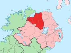
Limavady (/lɪməˈvædi/; from Irish Léim a' Mhadaidh, meaning "leap of the dog") is a market town in County Londonderry, Northern Ireland, with Binevenagh as a backdrop. Lying 17 miles (27 km) east of Derry and 14 miles (23 km) southwest of Coleraine, Limavady had a population of 12,043 people as of the 2001 Census—an increase of some 17% since 1991. In the 30 years between 1971 and 2011, Limavady's population nearly doubled.[2] Limavady is within Causeway Coast and Glens district.
Features
Limavady has undergone sustained growth during the past fifty years thanks to significant modern industrial development and public perception of the town as attractive and residential. Limavady, a lucrative service hub for the Roe Valley, has seen competition from other retail centres: Derry, Coleraine and, to a lesser extent, Ballymena. One of the distinctive features of the town's growth has been the predominant southward and eastward expansion of its suburbs, with the River Roe flood plain continuing to contain the town to the west and north. From 1988 to 2004, a total of 1,332 dwellings were built in the town, mainly at Bovally along the south eastern edge of the town. The large industrial estate at Aghanloo is 2 miles (3 km) north of the town.[2]
History
Limavady and its surrounding settlements derive from Celtic roots, although no-one is sure about the exact date of Limavady's origins. Estimates date from around 5 CE. Early records tell of Saint Columba, who presided over a meeting of the Kings at Mullagh Hill near Limavady in 575 CE, a location which is now part of the Roe Park Golf Resort.[3]
Gaelic Ireland was divided into kingdoms, each ruled by its own family or clan. In the Limavady area, the predominate family was the O'Cahans. Their mark is found everywhere in the town and surrounding area. O'Cahan's Rock is one of Limavady's main historical points. This is where, according to local myth, a dog belonging to one of the Chiefs jumped the river to get help from nearby clans after a surprise enemy attack. This gave Limavady its name, Limavady being the anglicised version of Leim an Mhadaidh, which means leap of the dog.[3] This rock, along with other relics of Limavady's history, can be seen at Roe Valley Country Park.
The town developed from a small Plantation settlement founded in the early 17th century. It had an early association with the linen industry, but did not benefit from subsequent expansion of linen manufacturing in the 19th century. As a result it remained a modest sized market town until the late 20th century.[2]
In 1941 RAF Limavady, a base for air patrols over the Atlantic during World War II, was opened just to the north of the town. The RAF left the base in 1945 but it continued as a naval air station until 1958, when the land was returned to agricultural use.
During the Troubles in Northern Ireland, four people were killed in or near Limavady by the Provisional Irish Republican Army. Two were members of the security forces and two were civilians who were killed by a bomb as they drove past Limavady Royal Ulster Constabulary station.
Townlands
Limavady sprang up within the townland of Rathbrady Beg in the parish of Drumachose and was original known as Newtown Limavady.[4] Over time, the urban area has expanded into the surrounding townlands. These include:[5][6]
- Bovally (from Irish Bó Bhaile, meaning "townland of cows")
- Coolessan (from Irish Cúil Leasáin, meaning "nook of the little fort")
- Enagh (from Irish Eanach, meaning "marsh")
- Killane (from Irish Coill Leathan, meaning "broad wood")
- Rathbrady Beg (from Irish Ráth Brighde Beag, meaning "little fort of St. Brigid")
- Rathbrady More (from Irish Ráth Brighde Mór, meaning "great fort of St. Brigid")
Politics
Limavady is in both the Causeway Coast and Glens District Council area and the East Londonderry constituency for elections to the Westminster Parliament and Northern Ireland Assembly.
Places of interest
- Limavady lies in the scenic Roe Valley area and the Roe Valley Country Park on the River Roe lies to the southwest of the town.
- The birthplace of New Zealand prime minister William Massey is on Irish Green Street. Nearby Massey Avenue is named after him.
- The archaeologically significant Broighter Gold collection was found nearby in 1896. It is currently in the National Museum in Dublin.
- Jane Ross, who first transcribed Londonderry Air, was born and lived in Limavady. A plaque is shown above her old house on Main Street.
Popular culture
Danny Boy
Limavady is most famous for the tune "Londonderry Air" collected by Jane Ross in the mid-19th century from a local fiddle player. The tune was later (ca. 1913) used for the song "Danny Boy".[3]
Between the 12th and 17th centuries, the area was ruled by the O'Cahan clan. "Danny Boy" is taken from a melody composed by O'Cahan bard Rory Dall O'Cahan. The original version concerns the passing of the Chief Cooey-na-Gall whose death brought an end to a long line of O'Cahan chiefs in Northern Ireland.[7]
Events
The town hosts international events such as the Danny Boy Festival, the Limavady Jazz and Blues Festival, the Roe Valley Folk Festival the Stendhal Festival of Art, and the Bishop Hervey International Summer School.[8]
Transport
Limavady is in close proximity to City of Derry Airport, 9 miles (15 km) to the west, and the Port of Londonderry, 13 miles (22 km) to the west.[2]
Road
- In 2003 a road bypass was completed to the north of Limavady at a cost of £11.5 million.[9] This bypass aimed to reduce the time taken to travel on the A2 between Derry and Coleraine.
Rail
- The Limavady Railway was a branch line to the main Derry – Belfast line. Limavady railway station opened on 29 December 1852, closed for passenger traffic on 3 July 1950 and finally closed altogether on 2 May 1955. Limavady Junction railway station opened on 1 March 1855 and finally closed on 17 October 1976.[10] Limavady is no longer served by the branch line – the nearest station is at Bellarena, approximately 5 miles (8.0 km) from the town.
Bellarena railway station has direct trains west to Londonderry and east to Castlerock, Coleraine (for stations to Portrush), and stations to Belfast Central and Belfast Great Victoria Street.
Canal
- The Broharris Canal was constructed in the 1820s when a cut, some 2 miles (3.2 km) long on the south shore of Lough Foyle near Ballykelly was made in the direction of Limavady. The inhabitants of Limavady appealed for the building of a canal from Lough Foyle to the town but were turned down, and the Broharris Canal was the nearest they came to achieving such a navigable link.
Education
There are four primary schools, three secondary schools, a regional college and a special needs school in Limavady. Limavady's schools are closely located in an 'education circle'. The three secondary schools are all located along the same stretch of road (Ballyquin Road and Irish Green Street), with Limegrove Special School opposite Limavady Grammar School, Termoncanice Primary opposite Limavady High School and St. Mary's High School. Limavady Central Primary School is located a short distance from the other schools.
Primary schools
- Termoncanice Primary School
- Roe Valley Integrated Primary
- Limavady Central Primary School
- Drumachose Primary School
- Gaelscoil Leim an mhadaidh
Secondary schools
Regional college
Special needs schools
- Rossmar Special School (formerly Limegrove/Greystone Hall)
Sport
- Limavady United F.C.
- Roe Valley F.C.
- Roe Rovers F.C.
- Newtowne F.C.
- Wolfhounds GAC is the local Gaelic Athletic Association club
- Newtown Y.F.C.
- Drummond Cricket Club
- Limavady Cricket Club
- Limavady Rugby Club
- Limavady Cycling Club
2011 Census
Limavady is classified as a medium town by the Northern Ireland Statistics and Research Agency (NISRA) (i.e. with population between 10,000 and 18,000 people). On Census day (March 2011) there were 12,043 people living in Limavady. Of these:
- 25.4% were aged under 16 years and 14.3% were aged 60 and over
- 48.8% of the population were male and 51.2% were female
5343 were from a Catholic background and 6236 were from a Protestant background[11]
- 5.1% of people aged 16–74 were unemployed.
For more details see: NI Neighbourhood Information Service
Notable people
- Bronagh Waugh- Actress, most notably from Hollyoaks.
- Gerry Mullan – Former Glentoran, Everton and Northern Ireland footballer.
- John Deighan – Current Derry Gaelic footballer.
- Ruth Kelly – Labour MP and former Cabinet Minister.
- Joesph Mulgrew - Poet known as "The Roe Valley Poet" & Nephew of the famous 'Largy Ploughman Poet'
- Samuel Young (1822–1918) MP was Limavady brewery founder.
- Victor Griffin – formerly Dean of St. Patrick's Cathedral, Dublin
- William Ferguson Massey – 19th Prime Minister of New Zealand (from 1912 to 1925) was born and educated in the town before migrating.
See also
| Wikimedia Commons has media related to Towns and villages in County Londonderry. |
References
- ↑ Banagher and Boveagh Churches (Ulster-Scots translation) Department of the Environment.
- 1 2 3 4 "Limavady". Planning Service – Draft Northern Area Plan 2016. Retrieved 15 July 2008.
- 1 2 3 "Limavady". Culture Northern Ireland. Archived from the original on 9 June 2008. Retrieved 15 July 2008.
- ↑ Parish of Drumachose www.ulsterancestry.com Retrieved 28 June 2010
- ↑ "Northern Ireland Placenames Project". Retrieved 12 June 2010.
- ↑ "OSI Limavady". Ordnance Survey Ireland. Retrieved 2 July 2010.
- ↑ "Dungiven". Culture Northern Ireland. Archived from the original on 9 June 2008. Retrieved 15 July 2008.
- ↑ http://www.herveysummerschool.com/
- ↑ "A2 Limavady bypass". Retrieved 29 December 2007.
- ↑ "Limavady and Limavady Junction stations" (PDF). Railscot – Irish Railways. Retrieved 28 October 2007.
- ↑ NISRA Key Statistics for Settlements Tables
External links
 Limavady travel guide from Wikivoyage
- Borough of Limavady
- Limavady and the Roe Valley by Jochen Lueg
| Large |  | |
|---|---|---|
| Medium | ||
| Small | ||
Italics denote settlements that are classed as towns but also have city status | ||