List of cultural property of national significance in Switzerland: Lucerne
This list contains all cultural property of national significance (class A) in the canton of Lucerne from the 2009 Swiss Inventory of Cultural Property of National and Regional Significance. It is sorted by municipality and contains 83 individual buildings, 27 collections, 17 archaeological finds and 6 other, special sites.
The geographic coordinates provided are in the Swiss coordinate system as given in the Inventory.
Adligenswil
| KGS No.? |
Picture | Name | Street Address | CH1903 X coordinate | CH1903 Y coordinate | Location |
|---|---|---|---|---|---|---|
| Unknown | ISOS Weiler: Dottenberg |
Alberswil
| KGS No.? |
Picture | Name | Street Address | CH1903 X coordinate | CH1903 Y coordinate | Location |
|---|---|---|---|---|---|---|
| 3629 |  |
Kastelen Tower | 642.047 | 221.923 | 47°08′49″N 7°59′35″E / 47.146944°N 7.992994°E | |
| 8587 | 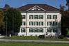 |
Schweizerisches Museum für Landwirtschaft und Agrartechnik | Burgrain 8 | 642.571 | 221.511 | 47°08′36″N 8°00′00″E / 47.143204°N 7.999864°E |
| Unknown | ISOS Spezialfall: Landscapes Kastelen |
Altishofen
| KGS No.? |
Picture | Name | Street Address | CH1903 X coordinate | CH1903 Y coordinate | Location |
|---|---|---|---|---|---|---|
| Unknown | ISOS Dorf: Altishofen |
Beromünster
| KGS No.? |
Picture | Name | Street Address | CH1903 X coordinate | CH1903 Y coordinate | Location |
|---|---|---|---|---|---|---|
| 3636 |  |
Canon and Prebendary House, North Group | Stift 7 – 11 | 656.877 | 228.591 | 47°12′21″N 8°11′22″E / 47.20581°N 8.189347°E |
| 10094 |  |
Canon and Prebendary House, South Group | Stift 33 – 38 | 656.943 | 228.527 | 47°12′19″N 8°11′25″E / 47.205228°N 8.19021°E |
| 3638 |  |
Former Administration Building (Gasthof Hirschen) | Hirschenplatz 1 | 657.005 | 228.592 | 47°12′21″N 8°11′28″E / 47.205808°N 8.191036°E |
| 10095 |  |
Kustorei | Stift 3 | 656.839 | 228.566 | 47°12′20″N 8°11′20″E / 47.205588°N 8.188842°E |
| 10093 |  |
Landessender Beromünster | Walterswil, Blosenberg | 655.525 | 227.964 | 47°12′01″N 8°10′17″E / 47.200285°N 8.171426°E |
| 3642 |  |
Provost's House | Stift 1 | 656.852 | 228.535 | 47°12′19″N 8°11′20″E / 47.205308°N 8.18901°E |
| 3637, 8908, 8621, 9304 |  |
Collegiate church with Archive, Library and Church Treasures |
656.939 | 228.604 | 47°12′21″N 8°11′25″E / 47.205921°N 8.190167°E | |
| Unknown | ISOS Kleinstadt / Flecken: Beromünster |
Buchrain
| KGS No.? |
Picture | Name | Street Address | CH1903 X coordinate | CH1903 Y coordinate | Location |
|---|---|---|---|---|---|---|
| Unknown | ISOS Spezialfall: Perlen (shared with Root) |
Buttisholz
| KGS No.? |
Picture | Name | Street Address | CH1903 X coordinate | CH1903 Y coordinate | Location |
|---|---|---|---|---|---|---|
| 3649 |  |
Buttisholz Castle and Surrounding Lands | 649.966 | 218.444 | 47°06′54″N 8°05′49″E / 47.115101°N 8.097011°E | |
| Unknown | ISOS Dorf: Buttisholz |
Dierikon
| KGS No.? |
Picture | Name | Street Address | CH1903 X coordinate | CH1903 Y coordinate | Location |
|---|---|---|---|---|---|---|
| 3653 |  |
Götzental Castle with Chapel | 671.245 | 216.069 | 47°05′30″N 8°22′37″E / 47.091792°N 8.376996°E | |
| Unknown | ISOS Weiler: Dierikon |
Egolzwil
| KGS No.? |
Picture | Name | Street Address | CH1903 X coordinate | CH1903 Y coordinate | Location |
|---|---|---|---|---|---|---|
| 3657 | Wauwilermoos (Egolzwil, Wauwil, Schötz, Ettiswil, Mauensee), Paleolithic-Neolithic Lake Shore Settlement |
644.530 | 225.500 | 47°10′44″N 8°01′34″E / 47.178955°N 8.026082°E |
Emmen
| KGS No.? |
Picture | Name | Street Address | CH1903 X coordinate | CH1903 Y coordinate | Location |
|---|---|---|---|---|---|---|
| 10097 |  |
Flugzeugmontagehalle Ruag | Hochdorfstrasse | 666.151 | 215.801 | 47°05′24″N 8°18′36″E / 47.08991°N 8.30987°E |
| 10098 | Rothenburger Bridge | Rothenburgstrasse / Bertiswilstrasse | 663.460 | 216.150 | 47°05′36″N 8°16′28″E / 47.093312°N 8.27448°E | |
| 8805 | 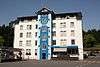 |
Von Moos Stahl AG, Historic Archive | Emmenweidstrasse 90 | 662.965 | 213.573 | 47°04′13″N 8°16′03″E / 47.070181°N 8.267602°E |
Ermensee
| KGS No.? |
Picture | Name | Street Address | CH1903 X coordinate | CH1903 Y coordinate | Location |
|---|---|---|---|---|---|---|
| Unknown | ISOS Dorf: Ermensee |
Escholzmatt
| KGS No.? |
Picture | Name | Street Address | CH1903 X coordinate | CH1903 Y coordinate | Location |
|---|---|---|---|---|---|---|
| Unknown | ISOS Dorf: Escholzmatt |
Ettiswil
| KGS No.? |
Picture | Name | Street Address | CH1903 X coordinate | CH1903 Y coordinate | Location |
|---|---|---|---|---|---|---|
| Unknown | Wauwilermoos (Egolzwil, Wauwil, Schötz, Ettiswil, Mauensee), Paleolithic-Neolithic Lake Shore Settlement |
644.530 | 225.500 | 47°10′44″N 8°01′34″E / 47.178955°N 8.026082°E | ||
| Unknown | ISOS Weiler: Seewagen |
Gettnau
| KGS No.? |
Picture | Name | Street Address | CH1903 X coordinate | CH1903 Y coordinate | Location |
|---|---|---|---|---|---|---|
| 10480 | Stadtägertli | Burgstelle | 639.830 | 220.500 | 47°08′03″N 7°57′49″E / 47.134281°N 7.96364°E | |
| Unknown | ISOS Spezialfall: Landscapes Kastelen |
Geuensee
| KGS No.? |
Picture | Name | Street Address | CH1903 X coordinate | CH1903 Y coordinate | Location |
|---|---|---|---|---|---|---|
| Unknown | ISOS Weiler: Krummbach |
Greppen
| KGS No.? |
Picture | Name | Street Address | CH1903 X coordinate | CH1903 Y coordinate | Location |
|---|---|---|---|---|---|---|
| Unknown | ISOS Dorf: Greppen |
Hasle
| KGS No.? |
Picture | Name | Street Address | CH1903 X coordinate | CH1903 Y coordinate | Location |
|---|---|---|---|---|---|---|
| 3683 |  |
Wallfahrtskirche Heiligkreuz | Heiligkreuz 201 | 646.425 | 200.009 | 46°56′58″N 8°02′54″E / 46.94954°N 8.048468°E |
| Unknown | ISOS Spezialfall: Wallfahrtsort Heiligkreuz |
Hitzkirch
| KGS No.? |
Picture | Name | Street Address | CH1903 X coordinate | CH1903 Y coordinate | Location |
|---|---|---|---|---|---|---|
| 3691 |  |
Former Teutonic Knights Commandry | Kommendeweg 3 | 662.594 | 230.793 | 47°13′30″N 8°15′54″E / 47.225098°N 8.265105°E |
| 3690 |  |
Richensee Megalithic Tower |
Megalithturm | 661.599 | 230.227 | 47°13′12″N 8°15′07″E / 47.220101°N 8.251891°E |
| 3671 |  |
Heidegg Castle with House and Chapel | Heidegg | 663.165 | 229.871 | 47°13′00″N 8°16′21″E / 47.216751°N 8.272515°E |
| 3689 | Seematt, Neolithic Lake Shore Settlement |
661.300 | 229.750 | 47°12′57″N 8°14′52″E / 47.215839°N 8.247879°E | ||
| Unknown | ISOS Dorf: Hitzkirch | |||||
| Unknown | ISOS Spezialfall: Richensee | |||||
| Unknown | ISOS Spezialfall: Castle Heidegg |
Hochdorf
| KGS No.? |
Picture | Name | Street Address | CH1903 X coordinate | CH1903 Y coordinate | Location |
|---|---|---|---|---|---|---|
| 9587 | Baldegg, Neolithic / Bronze Age Lake Shore Settlement |
663.300 | 226.000 | 47°10′55″N 8°16′26″E / 47.181922°N 8.273753°E |
Hohenrain
| KGS No.? |
Picture | Name | Street Address | CH1903 X coordinate | CH1903 Y coordinate | Location |
|---|---|---|---|---|---|---|
| 3715 |  |
Ruins of Nünegg Castle | 665.549 | 229.023 | 47°12′32″N 8°18′14″E / 47.208892°N 8.303861°E | |
| 3695 |  |
Former Knights Hospitaller Commandry | Dorf | 666.693 | 225.761 | 47°10′46″N 8°19′07″E / 47.179439°N 8.318478°E |
| 3696 | Ottenhusen | römischer Gutshof | 667.900 | 224.300 | 47°09′58″N 8°20′03″E / 47.166176°N 8.33418°E | |
| Unknown | ISOS Spezialfall: Hohenrain |
Horw
| KGS No.? |
Picture | Name | Street Address | CH1903 X coordinate | CH1903 Y coordinate | Location |
|---|---|---|---|---|---|---|
| 3702 |  |
Farm House Oberdorni | Oberdorni 903 | 668.013 | 206.787 | 47°00′31″N 8°19′59″E / 47.008645°N 8.333038°E |
Inwil
| KGS No.? |
Picture | Name | Street Address | CH1903 X coordinate | CH1903 Y coordinate | Location |
|---|---|---|---|---|---|---|
| 9588 |  |
Alt-Eschenbach, Medieval City Ruins, Ruined Castle |
669.500 | 218.750 | 47°06′58″N 8°21′16″E / 47.116091°N 8.354427°E |
Kriens
| KGS No.? |
Picture | Name | Street Address | CH1903 X coordinate | CH1903 Y coordinate | Location |
|---|---|---|---|---|---|---|
| 11621 | 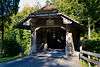 |
Hergiswald Bridge | 661.060 | 208.472 | 47°01′28″N 8°14′31″E / 47.024478°N 8.241836°E | |
| 3713 |  |
Pilgrimage Church Unser Liebe Frau im Hergiswald with Kaplanei | 660.610 | 208.280 | 47°01′22″N 8°14′09″E / 47.022792°N 8.235892°E | |
| Unknown | ISOS Spezialfall: Wallfahrtsort Hergiswald |
Luthern
| KGS No.? |
Picture | Name | Street Address | CH1903 X coordinate | CH1903 Y coordinate | Location |
|---|---|---|---|---|---|---|
| Unknown | ISOS Dorf: Luthern |
Luzern
| KGS No.? |
Picture | Name | Street Address | CH1903 X coordinate | CH1903 Y coordinate | Location |
|---|---|---|---|---|---|---|
| 9589 |  |
Old City, Medieval / Early Modern City | 665.750 | 211.600 | 47°03′08″N 8°18′14″E / 47.052164°N 8.303979°E | |
| 3748 |  |
Am Rhyn-Haus | Furrengasse 21 | 665.934 | 211.583 | 47°03′07″N 8°18′23″E / 47.051993°N 8.306398°E |
| 3751 |  |
Atelierhaus Blaesi | Adligenswilerstrasse 31 | 666.985 | 212.137 | 47°03′25″N 8°19′13″E / 47.056871°N 8.320311°E |
| 3720, 8494 |  |
Bourbaki-Panorama | Löwenplatz 11 | 666.297 | 212.134 | 47°03′25″N 8°18′41″E / 47.056913°N 8.311256°E |
| 3721 |  |
Paddle Steam Ship Gallia SGV (1913) | Werftstrasse | 666.700 | 211.200 | 47°02′54″N 8°18′59″E / 47.048471°N 8.316422°E |
| 3722 |  |
Paddle Steam Ship Schiller SGV (1906) | Werftstrasse | 666.700 | 211.200 | 47°02′54″N 8°18′59″E / 47.048471°N 8.316422°E |
| 3723 |  |
Paddle Steam Ship Stadt Luzern SGV (1928) | Werftstrasse Dampfschiff Stadt Luzern SGV (1928), | 666.700 | 211.200 | 47°02′54″N 8°18′59″E / 47.048471°N 8.316422°E |
| 3724 | 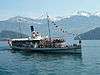 |
Paddle Steam Ship Unterwalden SGV (1902) | Werftstrasse | 666.700 | 211.200 | 47°02′54″N 8°18′59″E / 47.048471°N 8.316422°E |
| 3725 |  |
Paddle Steam Ship Uri SGV (1901) | Werftstrasse | 666.700 | 211.200 | 47°02′54″N 8°18′59″E / 47.048471°N 8.316422°E |
| 10412 |  |
Dreilindenpark with Villa and Surrounding Buildings |
Dreilindenstrasse 91–93 | 667.108 | 212.579 | 47°03′39″N 8°19′19″E / 47.060834°N 8.321995°E |
| 3758 |  |
Dula School House | Bruchstrasse 78 | 665.705 | 210.929 | 47°02′46″N 8°18′12″E / 47.046133°N 8.303289°E |
| 3726 |  |
Former Franciscan Church of St. Maria in der Au | Franziskanerplatz 1 a | 665.713 | 211.327 | 47°02′59″N 8°18′12″E / 47.049712°N 8.303452°E |
| 3737 |  |
Former Ritter‘scher Palast (Administration Building) | Bahnhofstrasse 15 | 665.777 | 211.397 | 47°03′01″N 8°18′15″E / 47.050336°N 8.304305°E |
| 9060, 8498 |  |
Former National Bank Building and Rosengart Collection | Pilatusstrasse 10 | 666.008 | 211.329 | 47°02′59″N 8°18′26″E / 47.049701°N 8.307335°E |
| 3744, 8495 |  |
Former Armory and Collection of the History Museum |
Pfisterngasse 24, 26 | 665.581 | 211.507 | 47°03′05″N 8°18′06″E / 47.051344°N 8.301741°E |
| 3763 |  |
Felsberg School House | Felsbergstrasse 10, 12 | 666.549 | 212.278 | 47°03′29″N 8°18′53″E / 47.058183°N 8.314593°E |
| 10100 |  |
Cemetery Friedental with Crematorium Jewish Cemetery and Memorial Hall |
Friedentalstrasse 40 | 665.535 | 212.530 | 47°03′38″N 8°18′05″E / 47.06055°N 8.301284°E |
| 3770 | Gewerbeschulhaus Heimbach | Heimbachweg 12 | 665.401 | 211.004 | 47°02′49″N 8°17′57″E / 47.046838°N 8.2993°E | |
| 3771, 8585 |  |
Gletschergarten with Museum | Denkmalstrasse 4 | 666.215 | 212.352 | 47°03′32″N 8°18′37″E / 47.058882°N 8.310208°E |
| 3727 |  |
Grand-Hotel National | Haldenstrasse 4 | 666.551 | 211.888 | 47°03′17″N 8°18′52″E / 47.054675°N 8.314562°E |
| 3775 |  |
Hammetschwandlift (shared with Ennetbürgen) | Bürgenstock | 672.816 | 206.000 | 47°00′04″N 8°23′46″E / 47.001057°N 8.396067°E |
| 3796 |  |
Main Post Office (Kreispostdirektion) | Bahnhofstrasse 3 | 666.098 | 211.444 | 47°03′03″N 8°18′31″E / 47.050726°N 8.308536°E |
| 3745 |  |
Haus Zurgilgen (zur Gilgen) | Kapellplatz 1 | 666.077 | 211.659 | 47°03′10″N 8°18′30″E / 47.052662°N 8.308291°E |
| 3782 |  |
Hotel Montana | Adligenswilerstrasse 22 | 666.935 | 212.086 | 47°03′23″N 8°19′11″E / 47.056417°N 8.319645°E |
| 3784 |  |
Hotel Schweizerhof | Schweizerhofquai 3 | 666.218 | 211.871 | 47°03′16″N 8°18′37″E / 47.054555°N 8.310177°E |
| 3728, 10634 |  |
Jesuit Church of St. Franz Xaver with Sacristy and Church Treasure | Bahnhofstrasse 11 a / Hirschengraben 8 | 665.840 | 211.409 | 47°03′02″N 8°18′18″E / 47.050437°N 8.305136°E |
| 3729 |  |
Kapellbrücke with Paintings and Wasserturm | Wesemlinstrasse 42 | 666.004 | 211.500 | 47°03′04″N 8°18′26″E / 47.051239°N 8.307307°E |
| 3791, 9336, 8905 |  |
Capuchin Monastery auf dem Wesemlin and Library and Provincial Archive of the Swiss Capuchins (German: Provinzarchiv der Schweizer Kapuziner or PAL) |
Wesemlinstrasse 42 | 666.449 | 212.670 | 47°03′42″N 8°18′48″E / 47.061719°N 8.313335°E |
| 3792 |  |
Allmend Barracks | Murmattweg 6 | 665.438 | 209.693 | 47°02′06″N 8°17′59″E / 47.035043°N 8.299598°E |
| 3787 |  |
Catholic Pauluskirche | Moosmattstrasse 2 | 665.697 | 210.463 | 47°02′31″N 8°18′11″E / 47.041943°N 8.303117°E |
| 3788 |  |
St. Karl's Church | St. Karlistrasse 23 | 664.859 | 211.986 | 47°03′21″N 8°17′32″E / 47.055724°N 8.292309°E |
| 3799, 8505 |  |
Landsitz Tribschen and Richard Wagner Museum | Wagnerweg 27 | 667.668 | 210.535 | 47°02′33″N 8°19′45″E / 47.042392°N 8.329061°E |
| 3732 |  |
Löwendenkmal with Chapel | Denkmalstrasse | 666.284 | 212.294 | 47°03′30″N 8°18′40″E / 47.058353°N 8.311108°E |
| 10102 |  |
Mühlesporne | Nadelwehr | 666.284 | 212.294 | 47°03′30″N 8°18′40″E / 47.058353°N 8.311108°E |
| 3807 |  |
Museggmagazin | Museggstrasse 37 | 665.629 | 211.697 | 47°03′11″N 8°18′09″E / 47.053049°N 8.302401°E |
| 3736 |  |
Rathaus (Town council house) | Kornmarkt 3 | 665.914 | 211.574 | 47°03′07″N 8°18′22″E / 47.051914°N 8.306133°E |
| 8497 |  |
Collection at the Natural History Museum | Kasernenplatz 6 | 665.526 | 211.543 | 47°03′06″N 8°18′04″E / 47.051674°N 8.301023°E |
| 8496 |  |
Art Museum Collection | Europaplatz 1 | 666.362 | 211.409 | 47°03′01″N 8°18′43″E / 47.050385°N 8.312005°E |
| 3823, 8841 |  |
Schweizerische Unfallversicherungsanstalt SUVA and the Archive of the SUVA | Fluhmattstrasse 1 | 666.142 | 212.067 | 47°03′23″N 8°18′33″E / 47.056326°N 8.309206°E |
| 3738 |  |
Spreuer Bridge | 665.570 | 211.560 | 47°03′07″N 8°18′06″E / 47.051822°N 8.301604°E | |
| 8790 |  |
Regional Archive of the Canton of Lucerne | Schützenstrasse 9 | 665.428 | 211.416 | 47°03′02″N 8°17′59″E / 47.050541°N 8.299715°E |
| 8869 | City Archive of Luzern | Industriestrasse 6 | 666.290 | 210.407 | 47°02′29″N 8°18′39″E / 47.04138°N 8.310911°E | |
| 10103 |  |
City Fortifications (not including the bridges) |
665.764 | 211.836 | 47°03′15″N 8°18′15″E / 47.054285°N 8.304197°E | |
| 3767 |  |
Collegiate church Yard im Hof | St. Leodegarstrasse 3 – 7 | 666.412 | 211.981 | 47°03′20″N 8°18′46″E / 47.055525°N 8.312747°E |
| 3740, 10635 |  |
Collegiate church St. Leodegar and Mauritius with Church Treasures |
St. Leodegarstrasse 5 a–d | 666.515 | 211.985 | 47°03′20″N 8°18′51″E / 47.055551°N 8.314103°E |
| 8499, 8779 |  |
Verkehrshaus of the Schweiz and Verkehrsarchiv des Verkehrshauses | Lidostrasse 5 | 668.175 | 211.735 | 47°03′11″N 8°20′09″E / 47.053133°N 8.335912°E |
| 10104, 8832 | |
Administration Building of the Gotthardbahn and Archives of the Bundesverwaltungsgerichts, Sozialrechtliche Abteilungen | Schweizerhofquai 6 | 666.347 | 211.919 | 47°03′18″N 8°18′43″E / 47.054974°N 8.311882°E |
| 3742 |  |
Villa Bellerive with Park | Bellerivestrasse 19 | 667.721 | 212.150 | 47°03′25″N 8°19′48″E / 47.056913°N 8.329999°E |
| 3743, 9335, 8930 |  |
Central and University Library of Lucerne with Musical and Special Collection |
Sempacherstrasse 10 | 666.011 | 211.175 | 47°02′54″N 8°18′26″E / 47.048316°N 8.307352°E |
| Unknown | ISOS Stadt: Luzern |
Malters
| KGS No.? |
Picture | Name | Street Address | CH1903 X coordinate | CH1903 Y coordinate | Location |
|---|---|---|---|---|---|---|
| 3837 |  |
Pilgrimage Chapel St. Jost In Blatten with Kaplanei | Luzernstrasse 149/150 | 659.720 | 210.280 | 47°02′27″N 8°13′28″E / 47.040862°N 8.224449°E |
| Unknown | ISOS Weiler: Blatten |
Marbach
| KGS No.? |
Picture | Name | Street Address | CH1903 X coordinate | CH1903 Y coordinate | Location |
|---|---|---|---|---|---|---|
| Unknown | ISOS Dorf: Marbach |
Mauensee
| KGS No.? |
Picture | Name | Street Address | CH1903 X coordinate | CH1903 Y coordinate | Location |
|---|---|---|---|---|---|---|
| 11750 | Wauwilermoos (Egolzwil, Wauwil, Schötz, Ettiswil, Mauensee), Paleolithic-Neolithic Lake Shore Settlement |
644.530 | 225.500 | 47°10′44″N 8°01′34″E / 47.178955°N 8.026082°E | ||
| Unknown | ISOS Spezialfall: Mauensee |
Meggen
| KGS No.? |
Picture | Name | Street Address | CH1903 X coordinate | CH1903 Y coordinate | Location |
|---|---|---|---|---|---|---|
| 3840 |  |
Catholic Piuskirche | Schlösslistrasse 101 | 670.957 | 211.014 | 47°02′47″N 8°22′21″E / 47.046357°N 8.372411°E |
| 3844 | 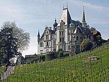 |
Meggenhorn Castle | Meggenhorn | 669.741 | 209.760 | 47°02′07″N 8°21′22″E / 47.035207°N 8.356217°E |
| Unknown | ISOS Spezialfall: Villenlandschaft Meggen |
Meierskappel
| KGS No.? |
Picture | Name | Street Address | CH1903 X coordinate | CH1903 Y coordinate | Location |
|---|---|---|---|---|---|---|
| 3845 |  |
Farm House Hinterspichten | Hinterspichten 23 | 676.469 | 218.796 | 47°06′57″N 8°26′47″E / 47.115737°N 8.446254°E |
Menznau
| KGS No.? |
Picture | Name | Street Address | CH1903 X coordinate | CH1903 Y coordinate | Location |
|---|---|---|---|---|---|---|
| Unknown | ISOS Weiler: Geiss |
Neudorf
| KGS No.? |
Picture | Name | Street Address | CH1903 X coordinate | CH1903 Y coordinate | Location |
|---|---|---|---|---|---|---|
| 3847 |  |
Pilgrimage Chapel Gormund with Kaplanei | Gormund 7 | 659.246 | 223.482 | 47°09′35″N 8°13′12″E / 47.15965°N 8.219942°E |
Nottwil
| KGS No.? |
Picture | Name | Street Address | CH1903 X coordinate | CH1903 Y coordinate | Location |
|---|---|---|---|---|---|---|
| 3851 | 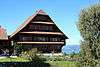 |
Farm House Mittler-Huprächtigen | Huprächtigen | 653.765 | 218.653 | 47°07′00″N 8°08′50″E / 47.116683°N 8.14709°E |
Pfaffnau
| KGS No.? |
Picture | Name | Street Address | CH1903 X coordinate | CH1903 Y coordinate | Location |
|---|---|---|---|---|---|---|
| 3855 |  |
Former Monastery of St. Urban | Sankt Urban 168 – 171 E | 630.403 | 231.302 | 47°13′55″N 7°50′24″E / 47.231941°N 7.840113°E |
| 3858 |  |
Catholic Parish Church of St. Vinzenz with Cemetery Chapel |
634.799 | 230.935 | 47°13′42″N 7°53′53″E / 47.228424°N 7.898133°E | |
| 3859 |  |
Rectory with Tithe barn | Altweg 7 a | 634.807 | 231.021 | 47°13′45″N 7°53′54″E / 47.229197°N 7.898245°E |
Reiden
| KGS No.? |
Picture | Name | Street Address | CH1903 X coordinate | CH1903 Y coordinate | Location |
|---|---|---|---|---|---|---|
| 9590 | Stumpen Early-Paleolithic Settlement |
640.220 | 233.850 | 47°15′16″N 7°58′12″E / 47.254335°N 7.969972°E |
Root
| KGS No.? |
Picture | Name | Street Address | CH1903 X coordinate | CH1903 Y coordinate | Location |
|---|---|---|---|---|---|---|
| Unknown | ISOS Spezialfall: Perlen (zusammen with Buchrain) |
Rothenburg
| KGS No.? |
Picture | Name | Street Address | CH1903 X coordinate | CH1903 Y coordinate | Location |
|---|---|---|---|---|---|---|
| 3873 |  |
Rothenburger Brücke (Bridge) | Bertiswilstrasse / Rothenburgstrasse | 663.451 | 216.158 | 47°05′36″N 8°16′28″E / 47.093385°N 8.274363°E |
Ruswil
| KGS No.? |
Picture | Name | Street Address | CH1903 X coordinate | CH1903 Y coordinate | Location |
|---|---|---|---|---|---|---|
| 3874 | Farm House Unter Rot | Under Rot 112 | 651.761 | 217.601 | 47°06′27″N 8°07′14″E / 47.107381°N 8.120565°E | |
| 3875 |  |
Catholic Church of St. Mauritius | Pfarrhofstrasse 2 | 652.250 | 215.120 | 47°05′06″N 8°07′36″E / 47.085027°N 8.12672°E |
| Unknown | ISOS Dorf: Ruswil | |||||
| Unknown | ISOS Spezialfall: Monastery Werthenstein |
Schötz
| KGS No.? |
Picture | Name | Street Address | CH1903 X coordinate | CH1903 Y coordinate | Location |
|---|---|---|---|---|---|---|
| 3883 |  |
Farm House Hinter Buttenberg | Buttenberg | 641.074 | 222.547 | 47°09′09″N 7°58′49″E / 47.152617°N 7.980223°E |
| 11761 | Wauwilermoos (Egolzwil, Wauwil, Schötz, Ettiswil, Mauensee), Paleolithic-Neolithic Lake Shore Settlement |
644.530 | 225.500 | 47°10′44″N 8°01′34″E / 47.178955°N 8.026082°E | ||
| Unknown | ISOS Spezialfall: Landscapes Kastelen |
Schwarzenberg
| KGS No.? |
Picture | Name | Street Address | CH1903 X coordinate | CH1903 Y coordinate | Location |
|---|---|---|---|---|---|---|
| 10107 | |
Farm House Scharmoos | Scharmoos 95 | 657.925 | 208.413 | 47°01′27″N 8°12′02″E / 47.024228°N 8.200593°E |
Sempach
| KGS No.? |
Picture | Name | Street Address | CH1903 X coordinate | CH1903 Y coordinate | Location |
|---|---|---|---|---|---|---|
| 3891 |  |
Catholic Church St. Martin Auf Kirchbühl with Charnel house | Kirchbühl 259 | 656.740 | 221.850 | 47°08′43″N 8°11′12″E / 47.14519°N 8.186691°E |
| 3896 |  |
Rathaus (Town council house) with a fountain | Stadtstrasse 28 | 657.093 | 220.820 | 47°08′09″N 8°11′28″E / 47.135896°N 8.191214°E |
| 3892 |  |
Schlachtkapelle St. Jakob | Schlacht / Sempacherstrasse | 658.674 | 221.964 | 47°08′46″N 8°12′44″E / 47.146047°N 8.212202°E |
| Unknown | ISOS Kleinstadt / Flecken: Sempach | |||||
| Unknown | ISOS Weiler: Kirchbühl |
Sursee
| KGS No.? |
Picture | Name | Street Address | CH1903 X coordinate | CH1903 Y coordinate | Location |
|---|---|---|---|---|---|---|
| 9337 | Museum of the Swiss Capuchin Monks and Monastery Library of the former Capuchin Monastery of Sursee |
Geuenseestrasse 2 a | 650.958 | 224.992 | 47°10′26″N 8°06′39″E / 47.173922°N 8.11082°E | |
| 3906 | Neolithic to Early Modern Settlement | 651.000 | 225.000 | 47°10′26″N 8°06′41″E / 47.17399°N 8.111375°E | ||
| 3899 |  |
Rathaus (Town council house) | 650.849 | 224.860 | 47°10′22″N 8°06′34″E / 47.172743°N 8.109367°E | |
| 3900, 8575 |  |
St. Urbanhof with City Museum | Theaterstrasse 9 | 650.850 | 224.960 | 47°10′25″N 8°06′34″E / 47.173642°N 8.109392°E |
| 3901 | 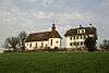 |
Pilgrimage Church of Mariazell with Zellkapelle | 651.660 | 224.940 | 47°10′24″N 8°07′12″E / 47.173399°N 8.120074°E | |
| Unknown | ISOS Kleinstadt / Flecken: Sursee |
Udligenswil
| KGS No.? |
Picture | Name | Street Address | CH1903 X coordinate | CH1903 Y coordinate | Location |
|---|---|---|---|---|---|---|
| 9143 |  |
Otto Pfeifer House | Haasenberg | 671.991 | 216.048 | 47°05′29″N 8°23′13″E / 47.091523°N 8.386817°E |
Vitznau
| KGS No.? |
Picture | Name | Street Address | CH1903 X coordinate | CH1903 Y coordinate | Location |
|---|---|---|---|---|---|---|
| 9621 | 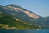 |
Steigfadbalm, Paleolithic Cave Dwelling | 680.250 | 207.925 | 47°01′03″N 8°29′39″E / 47.017514°N 8.494144°E |
Wauwil
| KGS No.? |
Picture | Name | Street Address | CH1903 X coordinate | CH1903 Y coordinate | Location |
|---|---|---|---|---|---|---|
| 9622 |  |
Wauwilermoos (Egolzwil, Wauwil, Schötz, Ettiswil, Mauensee), Paleolithic-Neolithic Lake Shore Settlement |
644.530 | 225.500 | 47°10′44″N 8°01′34″E / 47.178955°N 8.026082°E |
Werthenstein
| KGS No.? |
Picture | Name | Street Address | CH1903 X coordinate | CH1903 Y coordinate | Location |
|---|---|---|---|---|---|---|
| 3914 |  |
Wallfahrtskirche U. L. Frau | Oberdorf | 650.500 | 211.700 | 47°03′16″N 8°06′12″E / 47.054401°N 8.103294°E |
| Unknown | ISOS Spezialfall: Monastery Werthenstein |
Willisau
| KGS No.? |
Picture | Name | Street Address | CH1903 X coordinate | CH1903 Y coordinate | Location |
|---|---|---|---|---|---|---|
| 9623 |  |
Old City, Medieval / Early Modern City |
641.900 | 219.000 | 47°07′14″N 7°59′27″E / 47.120661°N 7.990785°E | |
| 3919 |  |
Catholic Church of St. Peter and Paul | 641.837 | 218.920 | 47°07′12″N 7°59′24″E / 47.119946°N 7.989947°E | |
| 3920 |  |
Landvogteischloss Bailiff's Castle |
Schlossstrasse 3 | 641.882 | 218.850 | 47°07′10″N 7°59′26″E / 47.119313°N 7.990534°E |
| 3921 |  |
Pilgrimage Chapel Heiligblut | 641.745 | 218.964 | 47°07′13″N 7°59′19″E / 47.120347°N 7.988739°E | |
| Unknown | ISOS Kleinstadt / Flecken: Willisau |
References
- All entries, addresses and coordinates are from: "Kantonsliste A-Objekte". KGS Inventar (in German). Federal Office of Civil Protection. 2009. Retrieved 25 April 2011.
External links
- Swiss Inventory of Cultural Property of National and Regional Significance, 2009 edition:
- "Revision of the PCP Inventory (Revision des KGS-Inventars)". KGS Forum. Federal Office of Civil Protection (13/2008). 2008.
This article is issued from Wikipedia - version of the 11/6/2016. The text is available under the Creative Commons Attribution/Share Alike but additional terms may apply for the media files.