List of crossings of the Lower Passaic River

The Lower Passaic River in New Jersey is the section of the Passaic River below the Great Falls which flows over the Dundee Dam to the river mouth at Newark Bay in the northeastern part of the state. Its midpoint generally delineates the Essex-Hudson and Passaic-Bergen county lines. Numerous spans, mostly moveable bridges, have been built over of the lower reaches of the river, which is tidally influenced to the dam at about mile point (MP) 17.4 and channelized to about MP 17. Once one of the most heavily used waterways in the Port of New York and New Jersey, it remains partially navigable for commercial marine traffic. While requests have significantly diminished since the mid-late 20th century, the bridge at MP 11.7 and those downstream from it are required by federal regulations to open with advance notice, with the exception of the first at MP 1.8, which is manned and opens on demand.
Early fixed crossings included turnpikes, sometimes built as plank roads. Wood, and later, metal bridges were constructed by competing railroads to access railyards, carfloat operations, passenger terminals, and ferries on the Hudson Waterfront. Rail lines led to further industrialization, urbanization-suburbanization, and the construction of vehicular bridges and streetcar lines. The advent of automobile age in the early and mid 20th century saw the building of highway bridges.
The Acquackanonk Bridge was dismantled in 1776 as George Washington retreated from Fort Lee. Another with the same name at the crossing was lost to flooding in 1903. The first railroad swing bridge in the United States was built in 1833. Numerous bridges have been demolished or fallen into disuse, while others have had their swing spans removed, replaced or immobilized. The first new bridge to be built since 2002, the Passaic River Crossing, opened in 2014.[1]
Crossings
| MP | Crossing | Image | Open | Carries/Carried | Locale/Connecting | Coordinates | Notes |
|---|---|---|---|---|---|---|---|
| 1.2 | PD Draw (unused-swing span removed) |
1869 1912 |
Newark and New York Railroad (CNJ) | Kearny Point & Newark Ironbound |
40°43′23″N 74°07′17″W / 40.72295°N 74.12126°W | Swing spand shifted to new alignment[2] | |
| Portway Bridge (proposed) |
Doremus Avenue to Central/Pennsylvania Aves | Kearny Point & Port Newark |
NJDOT to Wittpenn Bridge replacement | ||||
| Newark Plank Road (removed) |
PS | Kearny Point & Newark Ironbound |
Ferry Street first bridge 1795 | ||||
| 1.8 | Lincoln Highway Passaic River Bridge |  |
1941 | Lincoln Highway |
Kearny Point & Newark Ironbound |
40°43′57″N 74°07′05″W / 40.7324°N 74.1180°W | East Coast Greenway Raymond Boulevard NJRHP |
| 2.0 | Pulaski Skyway |  |
1932 | Kearny Point & Newark Ironbound |
no trucks, bicycles, or peds NJRHP & NRHP | ||
| 2.6 | Point-No-Point Bridge | |
Coordinates: 40°44′29″N 74°07′17″W / 40.74148°N 74.12136°W | Conrail Passaic and Harsimus Line (CSX) (NS) |
Kearny Meadows & Newark Ironbound |
PRR | |
| 2.7 | Chaplain Washington Bridge |  |
1952 | NJ Turnpike Eastern Spur |
Kearny Meadows & Newark Ironbound |
no bicycles or pedestrians | |
| 2.7 | Harry Laderman Bridge | 1970 | NJ Turnpike Western Spur |
Kearny Meadows & Newark Ironbound |
no bicycles or pedestrians | ||
| 4.6 | Jackson Street Bridge | 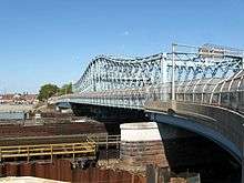 |
1903 | Jackson Street Frank E. Rodgers Blvd |
Harrison & Newark Ironbound |
NJRHP | |
| Pedestrian bridge (proposed) |
Harrison Riverfront Riverbank Park |
Harrison & Newark Ironbound |
|||||
| Market Street Bridge (removed) | 1868 1899 |
NJRR PRR |
Harrison & Newark Penn |
Swing span shifted to new alignment[3] | |||
| 5.0 | Amtrak Dock Vertical Lift (2 spans) |
 |
1935 (west) 1937 (east) |
Northeast Corridor Amtrak Northeast Corridor Line (NJT) North Jersey Coast Line (NJT) Raritan Valley Line (NJT) PATH |
Harrison & Newark Penn |
PRR & H&M NJRPH & NRHP | |
| Centre Street Bridge (removed) |
 |
1834 1911 |
New Jersey Railroad PRR H&M Route 158 |
Harrison & Downtown Newark Park Place Station |
Upper level added Converted from rail to vehicular bridge 1927 | ||
| 5.6 | Bridge Street Bridge |  |
1913 | Bridge Street & Harrison Avenue |
Harrison & Downtown Newark |
NJRHP | |
| 5.85 | Newark Drawbridge |  |
1903 | Montclair-Boonton Line (NJT) Morristown Line (NJT) Gladstone Branch (NJT) |
Harrison & Newark Broad Street Station | Morris and Essex Railroad (DL&W) | |
| 5.9 | William A. Stickel Memorial Bridge |  |
1949 | Harrison & Newark |
|||
| 6.0 | Clay Street Bridge |  |
1908 | Central Avenue Clay Street |
East Newark & Newark Broadway| |
||
| 6.35 | NX Bridge (abandoned) | 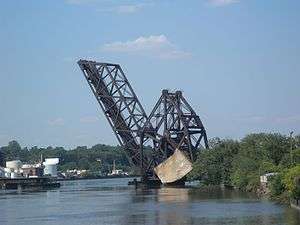 |
1922 | Newark Branch (Erie) | Harrison/East Newark & Newark |
Fixed open position | |
| 8.1 | WR Draw (unused) |
.tiff.png) |
1897 | New York & Greenwood Lake (Erie) Boonton Line (NJT) |
Arlington, Kearny & North Newark |
Kearny Riverbank Park | |
| 8.9 | Belleville Turnpike Bridge |  |
2002 | Arlington, Kearny & Belleville |
|||
| 10.7 | Avondale Bridge | 1905 | Park Avenue to Kingsland Avenue | Nutley & Lyndhurst |
aka DeJessa Memorial Bridge or Park Avenue Bridge | ||
| 11.7 | Lyndhurst Draw | |
1903 | Main Line (NJT) NS |
Clifton Delawanna & Lyndhurst |
DL&W & Erie Boonton Branch NJRHP | |
| Route 3 Passaic River Crossing | 2014 | |
Clifton & Rutherford/Lyndhurst |
NJDOT | |||
| 11.8 | Old Route 3 Passaic River Bridge (demolished) |
1949 demolished 2013 |
Clifton & Rutherford |
||||
| 13.2 | Union Avenue Bridge | 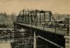 |
1896 2002 |
Union Avenue | Passaic & Rutherford |
aka Douglas O. Mead Bridge Swing removed and reconstructed (2002) | |
| BE Draw (removed) |
1833 (1st) | Paterson and Hudson River Railroad (Erie) | Passaic-Passaic Park & Rutherford/Wallington Carlton Hill |
Erie Main Line until 1963[4][5] | |||
| Acquackanonk Bridge (removed) |
Paterson Plank Road Paterson, Passaic and Rutherford Electric Railway |
Passaic & Wallington |
burned 1776 destroyed in flood 1903 | ||||
| 14.0 | Gregory Avenue Bridge | .tiff.png) |
1906 | Gregory Avenue to Paterson Avenue | Passaic & Wallington |
aka Slomiany Memorial Bridge Fixed closed position (1986) NJRHP | |
| 14.7 | Second Street Bridge | 1930 2002 |
Market Street | Passaic & Wallington |
aka Market Street Bridge Fixed closed position (1977) swing removed & reconstructed (2002) | ||
| 15.3 | Eighth Street Bridge | 1915 | Eighth Street Main Avenue |
Passaic & Wallington |
Fixed closed position (1976) NJRHP | ||
| Passaic Street Bridge | 1898 | Passaic Street |
Passaic & Garfield |
NJRHP | |||
| Bergen County Short-Cut | 1881 (1st) | Dundee Spur (Erie) New York and Greenwood Lake Railway (1996) |
Passaic & Garfield |
connections to NS/Bergen County Line (NJT) | |||
| Monroe Street Bridge | 1908 | Monroe Street | Passaic & Garfield |
1875-1878 bridge lost to flooding | |||
| Passaic Branch[6] (removed) |
1885 | Passaic and New York Railroad (NYS&W) | Passaic & Garfield |
Passaic Junction (rail yard) Botany Mills | |||
| Veterans Bridge | Ackerman Avenue Outwater Lane |
Clifton & Garfield |
aka Robertsford Bridge Dundee Canal Industrial Historic District | ||||
| 17.4 | Dundee Dam | 1861 | n/a | Clifton & Garfield |
Abbreviations
- CNJ=Central Railroad of New Jersey
- CSXT=CSX Transportation
- DL&W=Delaware, Lackawanna and Western Railroad
- Erie=Erie Railroad
- H&M=Hudson and Manhattan Railroad
- NRHP=National Register of Historic Places
- NJDOT=New Jersey Department of Transportation
- NJRHP=New Jersey Register of Historic Places
- NJT=New Jersey Transit
- NYS&W=New York, Susquehanna and Western Railway
- NS=Norfolk Southern Railway
- PATH=Port Authority Trans-Hudson
- PRR=Pennsylvania Railroad
- PS=Public Service Railway
See also
-
 Bridges portal
 -
 New Jersey portal
 - Timeline of Jersey City area railroads
- List of bridges, tunnels, and cuts in Hudson County, New Jersey
- List of crossings of the Hackensack River
- List of NJT moveable bridges
- List of fixed crossings of the North River (Hudson River)
Notes
- ↑ http://www.northjersey.com/community-news/smooth-sailing-set-for-rt-3-bridge-traffic-1.1067671
- ↑ "An Unusual Bridge-Moving Operation", Popular Mechanics Magazine, p. 26, July 1912, retrieved 2012-08-08
- ↑ "Civil Engineering Feat Old Bridge Removed and New One Substituted in 18 1/2 Minutes Crosses the Passaic", The New York Times, July 24, 1899, retrieved 2012-08-25
- ↑ http://railroad.net/forums/viewtopic.php?f=127&t=72041
- ↑ http://railroad.net/forums/viewtopic.php?f=127&t=72041
- ↑ "THE BRIDGE TORN DOWN; THE ERIE'S PROPERTY DESTROYED BY ITS RIVAL'S WORKMEN. FIVE HUNDRED HUNGARIANS PLUNGE INTO THE CANAL AFTER THE FLOATING TIMBER--A COMPROMISE.", The New York Times, July 11, 1885
Sources
- "Lower Passaic River Restoration Project Commercial Navigation Analysis" (PDF). United States Army Corps of Engineers. July 2, 2010 (2nd Revision). Retrieved 2012-08-20. Check date values in:
|date=(help) - "Historic Bridge Survey (1991-1994)". NJDOT. 2001. Retrieved 2012-08-21.
- "New Jersey and National Registers of Historic Places". NJ DEP - State Historic Preservation Office. Retrieved 2012-08-21.
- "Masonry and Metal The Historic Bridges of Bergen County, New Jersey" (PDF). Richard Grubb and Associates. 2008. Retrieved 2012-08-21.
- "33 CFR 117.739 - Passaic River.". Code of Federal Regulations. Coast Guard, Department of Homeland Security. Retrieved 2012-08-021.
updated to July 1, 2010
Check date values in:|access-date=(help) - "Section 117.739 - Passaic River." (PDF). Code of Federal Regulations Title 33 - Navigation and Navigable Waters Volume: 1. Government Publishing Office. July 1, 2002. Retrieved 2012-08-21.
- Report of the Assembly Committee Appointed to Inquire into the Condition of the Bridges over the Passaic and Hackensack Rivers in the Counties of Union, Essex, Hudson (Report). Trenton: New Jersey Assembly. 1865.
- "Bridges over the Passaic River". Passaic River Basin. Retrieved 2012-08-21.
- "Drawbridge Schedules". NJDOT. April 12, 2012. Retrieved 2012-08-21.
- "Bridgehunter: Passaic River". Retrieved 2012-08-21.
- "Bridgesnyc". Retrieved 2012-08-21.
- "FAQS about Recreational Boating on the Lower Passaic River". Passaic River Boat Club. Retrieved 2012-08-25.
- Jag9889. "Passaic River Bridges". Flickr. Retrieved 2012-08-25.
- "National Bridge Inventory Database". Retrieved 2012-08-21.
- "Passaic River, New Jersey" (PDF). Report of Channel Conditions 100 to 400 Feet Wide (ER 1130-2-306). US Army Corps of Engineers. September 14, 2010. Retrieved 2012-11-11.
- "Route 3 Passaic River Crossing". NJDOT. August 11, 2011. Retrieved 2012-08-25.
- "Acquakanonk Bridge". Revolutionary War in New Jersey. Retrieved 2012-08-08.
- Olsen, Kevin K. (2008), A Great Conveniency A Maritime History of the Passaic River, Hackensack River, and Newark Bay, American History Imprints, ISBN 9780975366776
External links
Ensslin, John C. (September 30, 2012), Many Bergen County bridges nearing end of lifespan, retrieved 2012-10-03