Lansing Charter Township, Michigan
| Lansing Charter Township, Michigan | |
|---|---|
| Charter township | |
 Lansing Charter Township, Michigan Location within the state of Michigan | |
| Coordinates: 42°45′26″N 84°31′43″W / 42.75722°N 84.52861°WCoordinates: 42°45′26″N 84°31′43″W / 42.75722°N 84.52861°W | |
| Country | United States |
| State | Michigan |
| County | Ingham |
| Organized | 1842 |
| Area | |
| • Total | 5.1 sq mi (13.1 km2) |
| • Land | 4.9 sq mi (12.8 km2) |
| • Water | 0.1 sq mi (0.3 km2) |
| Elevation | 869 ft (265 m) |
| Population (2010) | |
| • Total | 8,126 |
| • Density | 1,658.3/sq mi (640.3/km2) |
| Time zone | Eastern (EST) (UTC-5) |
| • Summer (DST) | EDT (UTC-4) |
| Area code(s) | 517 |
| FIPS code | 26-46020[1] |
| GNIS feature ID | 1626589[2] |
The Charter Township of Lansing is a charter township of Ingham County in the U.S. state of Michigan. As of the 2010 census, it had a population of 8,126. The township consists of five non-contiguous tracts of land: one on the west side of Lansing, three on the east side between Lansing and East Lansing, and one on the southeast side of Lansing.
History
The first white pioneer to purchase land in the township was Jacob F. Cooley in 1837.[3] The township was organized in 1842 in the northwest corner of Ingham County and was named after the hometown of one of the township's original settlers. The township experienced its first loss of land in 1859 when the unincorporated settlement of Lansing officially incorporated as a city out of seven square miles near the center of the township.
| Historical population | |||
|---|---|---|---|
| Census | Pop. | %± | |
| 1870 | 823 | — | |
| 1880 | 1,209 | 46.9% | |
| 1890 | 1,422 | 17.6% | |
| 1900 | 1,353 | −4.9% | |
| 1910 | 1,760 | 30.1% | |
| 1920 | 2,815 | 59.9% | |
| 1930 | 8,518 | 202.6% | |
| 1940 | 14,274 | 67.6% | |
| 1950 | 17,627 | 23.5% | |
| 1960 | 14,387 | −18.4% | |
| 1970 | 11,270 | −21.7% | |
| 1980 | 10,097 | −10.4% | |
| 1990 | 8,919 | −11.7% | |
| 2000 | 8,458 | −5.2% | |
| 2010 | 8,126 | −3.9% | |
| Est. 2014[4] | 8,145 | 0.2% | |
Township description
The cities of Lansing and East Lansing have incorporated much of the land that formerly constituted the township reducing the township from its original 36 square miles (93 km2) to its current 4.9 square miles (13 km2).
The western section of the township is the largest, and it includes almost all of the township's industrial developments including the large General Motors Lansing Craft Center and General Motors Lansing Metal Center automobile factories, both of which were closed and shuttered in early 2006.[5] It also contains the (closed) Waverly Golf Course and the adjacent West Michigan Avenue Park which includes a sledding hill and Little League Baseball field, both of which are owned and operated by the City of Lansing. At the north end of this section of the township north of Saginaw Highway (M-43) lies the CDP (census-designated place) of Edgemont Park.
The northeastern section of the township is heavily industrialized on its western end (west of Wood Road), but since 2002 this section has become the 'downtown' of Lansing Township with the construction of the Eastwood Towne Center, one of the largest shopping malls in Metropolitan Lansing, and the subsequent creation of the Lansing Township Downtown Development Authority to capture state and national funds for development.
The central eastern sections of the township are almost exclusively residential, save for a small strip of land that runs along either side of US-127. The northern portion of these two sections contain the large Groesbeck neighborhood, and the smaller southern portion includes part of the Urbandale neighborhood.
The southeastern section of the township is exclusively agricultural in nature, containing experimental farms for Michigan State University.
Geography
According to the United States Census Bureau, the township has a total area of 5.1 square miles (13 km2), of which 4.9 square miles (13 km2) is land and 0.1 square miles (0.26 km2) (1.98%) is water.
Demographics
2010
As of the census[1] of 2010, there were 8,126 people, 3,929 households, and 1,897 families residing in the township. The population density was 1,658.3 per square mile (634.8/km²). There were 4,319 housing units at an average density of 881.4 per square mile (337.4/km²). The racial makeup of the township was 76.3% White, 12.5% African American, 0.5% Native American, 2.6% Asian, 0.0% Pacific Islander, 3.5% from other races, and 4.7% from two or more races. Hispanic or Latino of any race were 10.9% of the population.
2000
There were 4,104 households out of which 22.8% had children under the age of 18 living with them, 34.3% were married couples living together, 12.6% had a female householder with no husband present, and 50.1% were non-families. 40.1% of all households were made up of individuals and 10.1% had someone living alone who was 65 years of age or older. The average household size was 2.05 and the average family size was 2.78.
In the township the population was spread out with 20.9% under the age of 18, 11.3% from 18 to 24, 32.9% from 25 to 44, 20.8% from 45 to 64, and 14.1% who were 65 years of age or older. The median age was 35 years. For every 100 females there were 87.7 males. For every 100 females age 18 and over, there were 83.1 males.
The median income for a household in the township was $41,017, and the median income for a family was $50,632. Males had a median income of $37,124 versus $28,829 for females. The per capita income for the township was $22,885. About 5.2% of families and 7.5% of the population were below the poverty line, including 8.2% of those under age 18 and 4.7% of those age 65 or over.
References
- 1 2 "American FactFinder". United States Census Bureau. Retrieved 2008-01-31.
- ↑ U.S. Geological Survey Geographic Names Information System: Lansing Charter Township, Michigan
- ↑ Raphael, Evelyn Huber (1975). A History of the Haslett-Lake Lansing Area, Meridian Township, Ingham County, Michigan. INCO Graphics, Mason, Michigan. pp. 8–9.
- ↑ "Annual Estimates of the Resident Population: April 1, 2010 to July 1, 2015". United States Census Bureau. Retrieved 2016-09-16.
- ↑ Barbara Wieland. "Lansing Metal Center lays off 300 as it prepares to close this year". Lansing State Journal. Retrieved July 9, 2009.
Further reading
- Balaskovitz, Andy. "Despite hurdles, consolidating Lansing, East Lansing and Lansing Township makes sense." Lansing City Pulse. Wednesday, November 28, 2012. News section. Available on NewsBank, Record Number: 33658e6f3e435749c466e59bf44dd1b692752.
External links
Municipalities and communities of Ingham County, Michigan, United States | ||
|---|---|---|
| Cities | 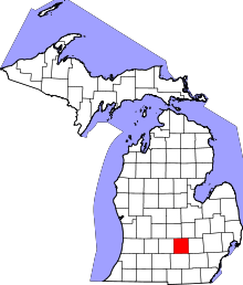 | |
| Villages | ||
| Charter townships | ||
| General law townships | ||
| CDPs | ||
| Other unincorporated communities | ||
| Footnotes | ‡This populated place also has portions in an adjacent county or counties | |