Lalevade-d'Ardèche
| Lalevade-d'Ardèche | |
|---|---|
|
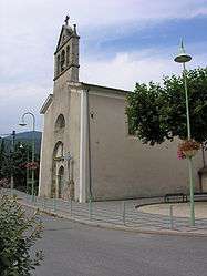
The church in Lalevade-d'Ardèche | |
 Lalevade-d'Ardèche | |
|
Location within Auvergne-Rhône-Alpes region  Lalevade-d'Ardèche | |
| Coordinates: 44°38′55″N 4°19′26″E / 44.6486°N 4.3239°ECoordinates: 44°38′55″N 4°19′26″E / 44.6486°N 4.3239°E | |
| Country | France |
| Region | Auvergne-Rhône-Alpes |
| Department | Ardèche |
| Arrondissement | Largentière |
| Canton | Thueyts |
| Intercommunality | Porte des Hautes Cévennes Ardéchoises |
| Government | |
| • Mayor (2008–2014) | Henri Merlet |
| Area1 | 2.27 km2 (0.88 sq mi) |
| Population (2067)2 | 1,184 |
| • Density | 520/km2 (1,400/sq mi) |
| Time zone | CET (UTC+1) |
| • Summer (DST) | CEST (UTC+2) |
| INSEE/Postal code | 07127 / 07380 |
| Elevation |
255–490 m (837–1,608 ft) (avg. 263 m or 863 ft) |
|
1 French Land Register data, which excludes lakes, ponds, glaciers > 1 km² (0.386 sq mi or 247 acres) and river estuaries. 2 Population without double counting: residents of multiple communes (e.g., students and military personnel) only counted once. | |
Lalevade-d'Ardèche is a commune in the Ardèche department in southern France.
It is the commune with the smallest area in the department.

Old train station, now the town hall
Economy
In the 19th century, the commune was an active industrial center, with coal mines and tanneries. Today, the economy is dominated by tourism.
Population
The population has remained relatively stable since 1900, with slight fluctuations.
| Historical population | ||
|---|---|---|
| Year | Pop. | ±% |
| 1906 | 1,349 | — |
| 1911 | 1,288 | −4.5% |
| 1921 | 1,301 | +1.0% |
| 1926 | 1,264 | −2.8% |
| 1931 | 1,278 | +1.1% |
| 1936 | 1,108 | −13.3% |
| 1946 | 1,124 | +1.4% |
| 1954 | 1,096 | −2.5% |
| 1962 | 1,129 | +3.0% |
| 1968 | 1,150 | +1.9% |
| 1975 | 1,199 | +4.3% |
| 1982 | 1,103 | −8.0% |
| 1990 | 1,012 | −8.3% |
| 1999 | 1,032 | +2.0% |
| 2008 | 1,167 | +13.1% |
See also
References
| Wikimedia Commons has media related to Lalevade-d'Ardèche. |
This article is issued from Wikipedia - version of the 3/15/2016. The text is available under the Creative Commons Attribution/Share Alike but additional terms may apply for the media files.