La Souche
| La Souche | |
|---|---|
|
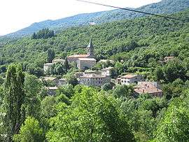
The church and surrounding buildings in La Souche | |
 La Souche | |
|
Location within Auvergne-Rhône-Alpes region  La Souche | |
| Coordinates: 44°37′48″N 4°11′53″E / 44.63°N 4.1981°ECoordinates: 44°37′48″N 4°11′53″E / 44.63°N 4.1981°E | |
| Country | France |
| Region | Auvergne-Rhône-Alpes |
| Department | Ardèche |
| Arrondissement | Largentière |
| Canton | Thueyts |
| Government | |
| • Mayor (2008–2014) | Thomas Albaladejo |
| Area1 | 31.52 km2 (12.17 sq mi) |
| Population (2011)2 | 356 |
| • Density | 11/km2 (29/sq mi) |
| Time zone | CET (UTC+1) |
| • Summer (DST) | CEST (UTC+2) |
| INSEE/Postal code | 07315 / 07380 |
| Elevation |
463–1,498 m (1,519–4,915 ft) (avg. 530 m or 1,740 ft) |
|
1 French Land Register data, which excludes lakes, ponds, glaciers > 1 km² (0.386 sq mi or 247 acres) and river estuaries. 2 Population without double counting: residents of multiple communes (e.g., students and military personnel) only counted once. | |
La Souche is a commune in the Ardèche department in southern France.
Geography
The commune is located in the Parc naturel régional des Monts d'Ardèche 15 km (9.3 mi) east of Aubenas; its main hamlets are located on the right bank of the river Lignon, which rises in the commune's western part, then flows east through the commune.
Population
| Historical population | ||
|---|---|---|
| Year | Pop. | ±% |
| 1962 | 346 | — |
| 1968 | 385 | +11.3% |
| 1975 | 334 | −13.2% |
| 1982 | 312 | −6.6% |
| 1990 | 288 | −7.7% |
| 1999 | 290 | +0.7% |
| 2006 | 335 | +15.5% |
| 2011 | 356 | +6.3% |
See also
References
| Wikimedia Commons has media related to La Souche. |
This article is issued from Wikipedia - version of the 10/28/2016. The text is available under the Creative Commons Attribution/Share Alike but additional terms may apply for the media files.