Antraigues-sur-Volane
| Antraigues-sur-Volane | |
|---|---|
|
Confluence of the Bise and the Volane | |
 Antraigues-sur-Volane | |
|
Location within Auvergne-Rhône-Alpes region  Antraigues-sur-Volane | |
| Coordinates: 44°43′09″N 4°21′30″E / 44.7192°N 4.3583°ECoordinates: 44°43′09″N 4°21′30″E / 44.7192°N 4.3583°E | |
| Country | France |
| Region | Auvergne-Rhône-Alpes |
| Department | Ardèche |
| Arrondissement | Largentière |
| Canton | Antraigues-sur-Volane |
| Intercommunality | Pays d'Aubenas-Vals |
| Government | |
| • Mayor (2014–2020) | Gilles Doz |
| Area1 | 13.46 km2 (5.20 sq mi) |
| Population (2010)2 | 544 |
| • Density | 40/km2 (100/sq mi) |
| Time zone | CET (UTC+1) |
| • Summer (DST) | CEST (UTC+2) |
| INSEE/Postal code | 07011 / 07530 |
| Elevation |
372–1,344 m (1,220–4,409 ft) (avg. 472 m or 1,549 ft) |
|
1 French Land Register data, which excludes lakes, ponds, glaciers > 1 km² (0.386 sq mi or 247 acres) and river estuaries. 2 Population without double counting: residents of multiple communes (e.g., students and military personnel) only counted once. | |
Antraigues-sur-Volane (Occitan: Entraigas) is a French commune in the Ardèche department in the Auvergne-Rhône-Alpes region of southern France.
The inhabitants of the commune are known as Antraiguains or Antraiguaines or alyternatively as Antraiguais or Antraiguaises[1]
Geography
Location
Antraigues-sur-Volane is located 5 kilometres north of Vals-les-Bains and 14 km north of Aubenas. The village lies on the edge of the Ardèche Cévennes with the northern boundary ending at the Mézilhac Pass and the Vivarais Mountains.
Access to the commune is on the D578 road from Val-les-Bains in the south to the village then continuing north through the heart of the commune to Laviolle in the north. There is also the D254 going west from the D578 just outside the village via a mountainous route to Labastide-sur-Besorgues in the west. Similarly the D318 road goes east from the village by a mountainous route to Genestelle in the east. The commune is mountainous with some mountain roads accessing parts of the commune.[2]
Hydrology
The Volane river flows from the north through the commune where it is joined by many tributaries including the Ruisseau de Rouyon, the Ruisseau du Bouchet, the Ruisseau des Fuels, the Rivière de Bise, the Ruisseau de Coupe (which forms the southern border of the commune), and many other unnamed streams.[2]
Neighbouring communes and villages[2]
 |
Laviolle | Mezilhac | Saint-Joseph-des-Bancs | |
| Labastide-sur-Besorgues | |
Genestelle | ||
| ||||
| | ||||
| Juvinas | Vals-les-Bains | Saint-Andeol-de-Vals |
History
- In 1841 the commune of Laviolle was created from a part of Antraigues
- Antraigues took its current name on 20 August 1989
- In the 1960s Mayor Jean Saussac brought in many artists such as Jacques Brel, Lino Ventura, Pierre Brasseur, Claude Nougaro, Alexander Calder, Allain Leprest Francesca Solleville, Aubret Isabelle and Jean Ferrat, who settled permanently in the village and became deputy mayors in charge of culture. As a result, the nickname "Little Saint Tropez of the Ardèche" was attributed to the commune[3]
Administration

List of Successive Mayors of Antraigues-sur-Volane[4]
| From | To | Name | Party | Position |
|---|---|---|---|---|
| 1820 | 1833 | Jean Pierre Chabannes | ||
| 1965 | 1977 | Jean Saussac | PCF | Artist (painter) |
| 1977 | 2001 | Michel Beyssade | ||
| 2001 | 2014 | Michel Pesenti | DVG | |
| 2014 | 2020 | Gilles Doz |
(Not all data is known)
Demography
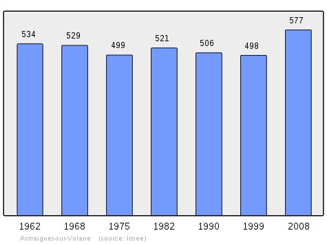
In 2010 the commune had 544 inhabitants. The evolution of the number of inhabitants is known through the population censuses conducted in the town since 1793. From the 21st century, a census of municipalities with fewer than 10,000 inhabitants is held every five years, unlike larger towns that have a sample survey every year.[Note 1]
| 1793 | 1800 | 1806 | 1821 | 1831 | 1836 | 1841 | 1846 | 1851 |
|---|---|---|---|---|---|---|---|---|
| 1,501 | 1,521 | 1,805 | 1,825 | 1,908 | 2,029 | 1,443 | 1,521 | 1,504 |
| 1856 | 1861 | 1866 | 1872 | 1876 | 1881 | 1886 | 1891 | 1896 |
|---|---|---|---|---|---|---|---|---|
| 1,505 | 1,576 | 1,413 | 1,434 | 1,495 | 1,386 | 1,413 | 1,348 | 1,411 |
| 1901 | 1906 | 1911 | 1921 | 1926 | 1931 | 1936 | 1946 | 1954 |
|---|---|---|---|---|---|---|---|---|
| 1,329 | 1,364 | 1,193 | 957 | 880 | 842 | 791 | 643 | 583 |
| 1962 | 1968 | 1975 | 1982 | 1990 | 1999 | 2006 | 2010 | - |
|---|---|---|---|---|---|---|---|---|
| 525 | 521 | 499 | 521 | 506 | 498 | 583 | 544 | - |
Sources : Ldh/EHESS/Cassini until 1962, INSEE database from 1968 (population without double counting and municipal population from 2006)

Distribution of Age Groups

The population of the town is relatively old. The rate of persons above the age of 60 years (34.2%) is significantly higher than the national rate (21.8%) and the departmental level (26.8%). Unlike the national and departmental allocations, the male population percentage for the commune is greater than the female population (49.8% against 48.7% nationally and 49.1% at the departmental level). The distribution of the population of the municipality by age groups in 2008 was as follows:
- 49.8% of men (0–14 years = 13.2%, 15–29 years = 11.8%, 30–44 years = 12.8%, 45–59 years = 30.8%, more than 60 years = 31.4%);
- 50.2% of women (0–14 years = 12.4%, 15–29 years = 8.2%, 30–44 years = 15.8%, 45–59 years = 26.7%, more than 60 years = 36.8%).
Percentage Distribution of Age Groups in Antraigues-sur-Volane and Ardèche Department in 2008
| Antraigues | Antraigues | Ardèche | Ardèche | |
|---|---|---|---|---|
| Age Range | Men | Women | Men | Women |
| 0 to 14 Years | 13.2 | 12.4 | 18.7 | 16.9 |
| 15 to 29 Years | 11.8 | 8.2 | 15.5 | 14.2 |
| 30 to 44 Years | 12.8 | 15.8 | 20.2 | 19.2 |
| 45 to 59 Years | 30.8 | 26.7 | 21.7 | 20.6 |
| 60 to 74 Years | 20.0 | 16.4 | 15.7 | 16.0 |
| 75 to 89 Years | 10.7 | 17.4 | 7.8 | 11.6 |
| 90 Years+ | 0.7 | 3.0 | 0.4 | 1.5 |
Sources:
- Evolution and Structure of the population of the Commune in 2008, INSEE.
- Evolution and Structure of the population of the Department in 2008, INSEE.
Culture and heritage

Civil heritage
- A Tower on the village hilltop
Religious heritage
- The Chapel of Saint-Roch
- The Parish Church contains a number of items that are registered as historical objects:
Environmental heritage
The commune has been an integral part of the Regional Natural Park of Monts d'Ardèche since its inception on 9 April 2001. The commune has two ZNIEFF type II areas in its territory named: "Line of the crest of the Mézilhac to the Escrinet Pass"[10] "Watersheds of the Volane, the Dorne, and the Bézorgues" [11]
The town also includes four ZNIEFF type I areas:
- "Rocks and moors of the volcano forest"
- "Streams of the Volane, the Mas, the Bise, and the Gamondes"
- "Plateau of Pradou and the Field of Mars"
- "Slopes of the Crau volcano"
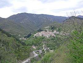
Panoramic view

Notable People linked to the commune

- Jean-Louis Giraud-Soulavie (1752-1813), also known as Father Soulavie, geologist, diplomat, a native of Antraigues although born in Largentière, appointed vicar of Antraigues in 1776
- Louis-Alexandre de Launay, Count of Antraigues (1753-1812)
- Antoinette Saint-Huberty (1756-1812), famous opera singer, wife of Louis-Alexandre de Launay, Countess of Antraigues
- François-Joseph Gamon (1767-1832), French politician, born in Antraigues
- Edouard Froment (1884-1973), MP for the Ardeche and former President of the General Council of the Ardèche, died at Antraigues on 13 March 1973
- Jean Saussac (1922-2005), painter, former mayor of Antraigues and decorator for films including Le Vieux Fusil, Le Secret, and Les Grandes gueules
- Jean Ferrat (1930-2010), poet, lyricist, and French singer. Antraigues, where he settled in 1964, inspired him including his song La Montagne. He was deputy mayor during the 1970s. He is buried in the local cemetery with his brother André
- Christine Sèvres born Boissonnet (1931-1981), wife of Jean Ferrat
- Michel Teston (1944- ), General Counsel for the canton, Senator for the Ardeche, and former president of the General Council of the Ardèche
- Allain Leprest (1954-2011), French poet and singer, died in Antraigues on 15 August 2011
See also
Notes and references
Notes
- ↑ At the beginning of the 21st century, the methods of identification have been modified by law No. 2002-276 of 27 February 2002 , the so-called "law of local democracy" and in particular Title V "census operations" which allow, after a transitional period running from 2004 to 2008, the annual publication of the legal population of the different French administrative districts. For municipalities with a population greater than 10,000 inhabitants, a sample survey is conducted annually, the entire territory of these municipalities is taken into account at the end of the period of five years. The first "legal population" after 1999 under this new law came into force on 1 January 2009 and was based on the census of 2006.
References
- ↑ Inhabitants of Ardeche (French)
- 1 2 3 Google Maps
- ↑ The Four colours of the Ardèche : on the touristic routes of Vivarais, Gilbert Freuchet, Michel Rissoan, Julie Bouleau (French)
- ↑ List of Mayors of France
- ↑ Ministry of Culture, Palissy PM07001315 Statue: The Virgin of the Immaculate Conception bringing down the serpent (French)
- ↑ Ministry of Culture, Palissy PM07001314 Statue: Saint Roch (French)
- ↑ Ministry of Culture, Palissy PM07001313 Statue: Saint Roch (French)
- ↑ Ministry of Culture, Palissy PM07001312 Statue: Saint Jean François Régis (French)
- ↑ Ministry of Culture, Palissy PM07001311 Painting: Saint Bauzille, martyred deacon (French)
- ↑ Line of the crest of the Mézilhac to the Escrinet Pass: No. 0707, DIREN Rhône-Alpes (French)
- ↑ Watersheds of the Volane, the Dorne, and the Bézorgues: No. 0708, DIREN Rhône-Alpes (French)
External links
| Wikimedia Commons has media related to Antraigues-sur-Volane. |
- Antraigues-sur-Volane on the old National Geographic Institute website (French)
- Antraigues-sur-Volane on Lion1906
- Antraigues-sur-Volane on Google Maps
- Antraigues-sur-Volane on Géoportail, National Geographic Institute (IGN) website (French)
- Antraigues on the 1750 Cassini Map
- Antraigues-sur-Volane on the INSEE website (French)
- INSEE (French)