Kendall Township, Kendall County, Illinois
| Kendall Township | |
|---|---|
| Township | |
 Location in Kendall County | |
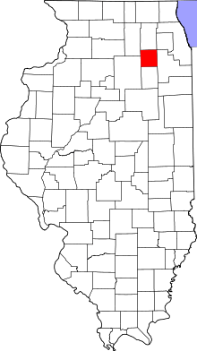 Kendall County's location in Illinois | |
| Coordinates: 41°35′16″N 088°25′51″W / 41.58778°N 88.43083°WCoordinates: 41°35′16″N 088°25′51″W / 41.58778°N 88.43083°W | |
| Country | United States |
| State | Illinois |
| County | Kendall |
| Area | |
| • Total | 39.22 sq mi (101.6 km2) |
| • Land | 39.09 sq mi (101.2 km2) |
| • Water | 0.13 sq mi (0.3 km2) 0.33% |
| Elevation[1] | 682 ft (208 m) |
| Population (2010) | |
| • Total | 7,739 |
| • Density | 198/sq mi (76/km2) |
| FIPS code | 17-39454[2] |
| GNIS feature ID | 0429202 |
Kendall Township is located in Kendall County, Illinois. As of the 2010 census, its population was 7,739 and it contained 2,875 housing units.[3]
Kendall Township was named after the county, which was named after Amos Kendall, a powerful Democratic politician in the Andrew Jackson administration. Kendall later became a business partner of Samuel F.B. Morse, inventor of the Morse Code and the electric telegraph, and made his fortune with Morse.
Yorkville's division amongst Bristol and Kendall Townships mirrors the fact that, until the 1950s, The City of Yorkville was situated along the south bank of the Fox River, while the Village of Bristol was situated to the north. When the communities consolidated to form the United City of Yorkville (16 Apr 1957), a small community in Bristol Township, named "Bristol Station", was allowed to become the new Bristol, Illinois (unincorporated).
Geography
It is located at 41.619626 N, -88.442966 W. According to the 2010 census, the township has a total area of 39.22 square miles (101.6 km2), of which 39.09 square miles (101.2 km2) (or 99.67%) is land and 0.13 square miles (0.34 km2) (or 0.33%) is water.[3]
Government
The township is governed by an elected Town Board of a Supervisor and four Trustees. The Township also has an elected Assessor, Clerk, and Highway Commissioner. Kendall County has its main offices, courthouse, and central County Seat within Yorkville.
References
- "Kendall Township, Kendall County, Illinois". Geographic Names Information System. United States Geological Survey. Retrieved 2010-02-20.
- ↑ "US Board on Geographic Names". United States Geological Survey. 2007-10-25. Retrieved 2008-01-31.
- ↑ "American FactFinder". United States Census Bureau. Retrieved 2008-01-31.
- 1 2 "Population, Housing Units, Area, and Density: 2010 - County -- County Subdivision and Place -- 2010 Census Summary File 1". United States Census. Retrieved 2013-05-28.
Municipalities and communities of Kendall County, Illinois, United States | ||
|---|---|---|
| Cities | ||
| Villages | ||
| Townships | ||
| CDP | ||
| Other unincorporated communities |
| |
| Footnotes | ‡This populated place also has portions in an adjacent county or counties | |
| Major city |  | |
|---|---|---|
| Cities (over 30,000 in 2010) | ||
| Towns and villages (over 30,000 in 2010) |
| |
| Counties | ||
| Regions | ||
| Sub-regions | ||