Janjira State
| Janjira State जंजिरा रियासत | |||||
| Princely State of British India In union with Jafrabad (1759 - 1948) | |||||
| |||||
|
Flag | |||||
 | |||||
| History | |||||
| • | Established | 1489 | |||
| • | Indian independence | 1948 | |||
| Area | |||||
| • | 1931 | 839 km2 (324 sq mi) | |||
| Population | |||||
| • | 1931 | 110,389 | |||
| Density | 131.6 /km2 (340.8 /sq mi) | ||||
| Today part of | Maharashtra, India | ||||
| | |||||

Janjira State[1] was a princely state in India during the British Raj. Its rulers were a Sidi dynasty of African descent and the state was under the suzerainty of the Bombay Presidency.
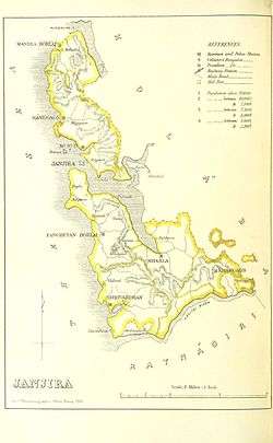
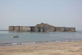
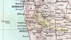
Janjira State was located on the Konkan coast in the present-day Raigad district of Maharashtra. The state included the towns of Murud and Shrivardhan, as well as the fortified island of Janjira, just off the coastal village of Murud, which was the capital and the residence of the rulers. The state had an area of 839 km2, not counting Jafrabad, and a population of 110,389 inhabitants in 1931. Jafrabad, or Jafarabad state was a dependency of the Nawab of Janjira State located 320 km to the NNW.
History
In 1489 an African trader at the service of the Ahmadnagar Sultanate took over the island of Janjira and established his rule. In the century that followed the rulers put themselves under the overlordship of the Sultanate of Bijapur. During the seventeenth and eighteenth century Janjira successfully resisted the repeated attacks of the Maratha Empire.
According to Ottoman's record. after Portuguese fleet ferociously routed and defeated by the Ottoman Navy; In 1587 at Yemen, From this moment onwards the Mughal Empire's prestigious vassals at Janjira played important role to give pressure to the Portuguese.[2]
There's further record of Cooperation with the Ottoman Empire when the Ottoman fleet first arrived in Aceh prior to Ottoman expedition to Aceh has included 200 Malabar sailors from Janjira to aid the region Batak and the Maritime Southeast Asia in 1539.[3] Fernão Mendes Pinto Particularly noted the Ottoman admiral named Kurtoğlu Hızır Reis has set sail of 22 ships carrying soldiers, military equipment and other supplies, and visited Aden, Djibouti, Muscat, Hormuz, Debal, Surat, Janjira, and Lanka (Sri Lanka) before arrived at Aceh in 1569
The ruler of Janjira State was officially recognized as Nawab by the Mughal Emperor Aurangzeb in 1676, even though the rulers of Janjira had used the title earlier. In 1759 Janjira State entered into personal union with Jafarabad State, located far away to the north on the coast of Gujarat. In 1762 Jafarabad was transferred to the Nawab of Janjira, who paid the debts of the state and appointed a governor.
According to one records at one time Sultan Aurangzeb supplied the Siddis of Janjira state with 2,000 men, provisions, ammunitions along with two Frigates and two large Man-of-war battleships. the ship arrived at Bombay harbor under the commands of Siddi Kasim and Siddi Sambal at 1677.[4] The largest Mughal ship named Ganj-I-Sawai Which equipped with 800 guns and 400 musketeer type soldiers also stationed in the port of Surat[5]
Another record from East India Company factory which written 1673 has reported the Siddis fleet which wintered from Bombay has five Frigates and two Man-of-wars beside of fifteen grabs vessels.[6] It is because the formidable naval warfare skills of Siddis in Janjira that Aurangzeb granting annual payment of 400.000 Rupee for the maintenance of their fleet[7]
When the British came to the Konkan area, the repeated attacks of the Marathas against Janjira ceased. Janjira State was administered as part of the Deccan States Agency of the Bombay Presidency, founded in 1799. In the nineteenth century the rulers maintained a military force of 123 men.[8]
Following the independence of India in 1947, the island's inhabitants had expressed the desire to remain as a separate state. Their decision, however, was disregarded[9] and Janjira State acceded to the Indian Union on 8 March 1948,[10] becoming part of Bombay Province.[9]
Rulers
The royal family of Janjira were Sidis, also known as 'Habshi', assumed to be from Abyssinia. Initially the rulers of the state held the title of 'Wazir', but after 1803 the title of 'Nawab' was officially recognized by the British Raj. They were entitled to an 11 gun salute by the British authorities.[10]
Wazirs of Janjira
- 1676 - 1703 Kasim Yaqut Khan II (d. 1703)
- 1703 - 1707 Amabat Yaqut Khan II
- 1707 - 1732 Surur Yakut Khan II (d. 1732)
- 1732 - 1734 Hasan Khan (1st time) (d. 1746)
- 1734 - 1737 Sumbul Khan
- 1737 - 1740 `Abd al-Rahman Khan
- 1740 - 1745 Hasan Khan (2nd time) (s.a.)
- 1745 - 1757 Ibrahim Khan I (1st time) (d. 1761)
- 1757 Mohammad Khan I (d. 1757)
- 1757 - 1759 Ibrahim Khan I (2nd time) (s.a.)
Thanadars of Jafarabad and Wazirs of Janjira
- 1759 - 1761 Ibrahim Khan I (s.a.)
- 1761 - 1772 Yaqut Khan (usurper to 6 Jun 1772) (d. 1772)
- 1772 - 1784 `Abd al-Rahim Khan (d. 1784)
- 1784 - 1789 Jauhar Khan (d. 1789)
- - in dispute with -
- 1784 - 1789 `Abd al-Karim Yaqut Khan
- - in dispute with -
- 1789 - 1794 Ibrahim Khan II (d. 1826)
- 1794 - 1803 Jumrud Khan (d. 1803)
Nawabs
- 1803 - 1826 Ibrahim Khan II (s.a.)
- 1826 - 31 Aug 1848 Mohammad Khan I (d. 1848)
- 31 Aug 1848 - 28 Jan 1879 Ibrahim Khan III (b. 1825 - d. 1879)
- 28 Jan 1879 - 2 May 1922 Ahmad Khan (b. 1862 - d. 1922) (from 1 Jan 1895, Sir Ahmad Khan)
- 28 Jun 1879 - 11 Oct 1883 .... -Regent
- 2 May 1922 - 15 Aug 1947 Mohammad Khan II (b. 1914 - d. 1972)
- 2 May 1922 - 9 Nov 1933 Kulsum Begum (f) -Regent (b. 1897 - d. 1959)[11]
See also
- Jafarabad State
- Murud-Janjira
- Sachin State
- Gowalkot and Anjanvel
- Political integration of India
- Deccan States Agency
References
- ↑ The History and Register of the Princely Families and States of India
- ↑ Ottoman court chroniclers (1588). Muhimme Defterleri, Vol. 62 f 205 firman 457, Avail Rabiulavval 996.
- ↑ Cambridge illustrated atlas, warfare: Renaissance to revolution, 1492–1792 by Jeremy Black p.17
- ↑ Shanti Sadiq Ali (1996). The African Dispersal in the Deccan: From Medieval to Modern Times. Paris: Orient Blackswan. pp. 260 Pages. ISBN 8125004858.
- ↑ Roy, Kaushik (30 Mar 2011). War, Culture and Society in Early Modern South Asia, 1740-1849 (Volume 3 Asian States and Empires ed.). Taylor & Francis. p. 13. ISBN 9781136790874. Retrieved 8 11 2015. Check date values in:
|access-date=(help) - ↑ Philip MacDougall (1996). Naval Resistance to Britain's Growing Power in India, 1660-1800: The Saffron Banner and the Tiger of Mysore Volume 10 of Worlds of the East India Company, ISSN 1752-5667. Boydell & Brewer Ltd. pp. 222 Pages. ISBN 1843839482.]
- ↑ Philip MacDougall (1996). Naval Resistance to Britain's Growing Power in India, 1660-1800: The Saffron Banner and the Tiger of Mysore Volume 10 of Worlds of the East India Company, ISSN 1752-5667. Boydell & Brewer Ltd. pp. 222 Pages. ISBN 1843839482.]
- ↑ Great Britain India Office. The Imperial Gazetteer of India. Oxford: Clarendon Press, 1908
- 1 2 Royalark - Janjira
- 1 2 Janjira Princely State (11 gun salute)
- ↑
- 7 MAY 2010 - TILL DATE ZAINUL ABEDIN KHAN (M) (B. 1988- ABHI HUM ZINDA HAIN)
External links
 Media related to Janjira State at Wikimedia Commons
 - Janjira State coat of arms
- A Trip to Murud Janjira Fort
Coordinates: 18°18′N 73°00′E / 18.300°N 73.000°E
