Phaltan State
| Phaltan State फलटण रियासत | |||||
| Princely State of British India | |||||
| |||||
|
Flag | |||||
 | |||||
| History | |||||
| • | Established | 14th century | |||
| • | Independence of India | 1948 | |||
| Area | |||||
| • | 1931 | 1,028 km2 (397 sq mi) | |||
| Population | |||||
| • | 1931 | 58,761 | |||
| Density | 57.2 /km2 (148 /sq mi) | ||||
| Today part of | Maharashtra, India | ||||
| | |||||

Phaltan State[1] was one of the non-salute Maratha princely states of British India. It was under the central division of the Bombay Presidency, under the states of the Kolhapur-Deccan Residency, Satara Agency and later the Deccan States Agency. Its capitan was Phaltan town, located in present-day Maharashtra.
It had been one of the Satara Jagirs, which included Bhor, Aundh, Phaltan, Jath, Daphlapur and Akalkot. Its flag was a rectangular bicolor, orange over green.
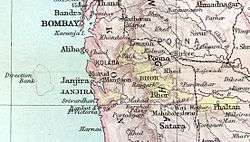
Geography
The state measured 397 square miles (1,028 km²) in area. According to the 1901 census, the population showed a decrease of 31% in the decade at 45,739. The population of the town itself was 9,512 in that year.
History
The Hindu ruling family was descended from Naik Nimbaji Nimbalkar (1284–1291), a Maratha who received a grant from a Mughal emperor in the 14th century. The ruler had the title of Raja, or Naik Nimbalkar. The first wife, Sai Bai, of 17th century emperor Shivaji was from Phaltan. Major HH Raja Bahadur Shrimant Malojirao Mudhojirao Nanasaheb Naik Nimbalkar IV was the last Ruler of Phaltan.
In 1901, the state enjoyed revenue estimated at £13,000- and paid a tribute to the British Raj of £640. Phaltan acceded to the Dominion of India on 8 March 1948 and is currently a part of Maharashtra state.[2]
List of Rulers
- Nimbraj I Nimbalkar, Naik 1284-1291
- Padakhala Jagdevrao Dharpatrao Nimbalkar, Naik 1291-1327
- Nimbraj II Nimbalkar, Naik 1327-1349
- Vanang Bhupal Nimbalkar, Naik 1349-1374
- Vanangpal Nimbalkar, Naik 1390-1394
- Vangoji I Nimbalkar, Naik 1394-1409
- Maloji I Nimbalkar, Naik 1409-1420
- Baji I Nimbalkar, Naik 1420-1445
- Powwarao Nimbalkar, Naik 1445-1470
- Baji II Nimbalkar, Naik 1470-1512
- Mudhoji I Nimbalkar, Naik 1512-1527
- Baji Dharrao Nimbalkar, Naik 1527-1560
- Maloji II Nimbalkar, Naik 1560-1570
- Vangoji II Jagpalrao Nimbalkar, Naik 1570-1630
- Mudhoji II Nimbalkar, Naik 1630-1644
- Bajaji I Nimbalkar, Naik 1644-1676
- Vangoji III Nimbalkar, Naik 1676-1693
- Janoji Nimbalkar, Naik 1693-1748
- Mudhojirao III Nimbalkar, Naik 1748-1765
- Sayajirao Nimbalkar, Naik 1765-1774
- Maloji III Rao Nimbalkar, Naik 1774-1777
- Janrao II Nimbalkar, Naik 1777-1827
- Bajaji II Rao Nimbalkar, Naik 1827-1841
- Mudhoji IV Rao Naik Nambalkar, Raja Shrimant, 1841-1916 (longest-reigning monarch in India)
- Maloji IV Rao Mudhojirao Naik Nimbalkar, Raja Bahadur Shrimant 1916-1948
See also
References
- ↑ Imperial Gazetteer of India, v. 22, p. 295.
- ↑
 This article incorporates text from a publication now in the public domain: Chisholm, Hugh, ed. (1911). "article name needed". Encyclopædia Britannica (11th ed.). Cambridge University Press.
Coordinates: 17°59′40″N 78°41′20″E / 17.99444°N 78.68889°E