Jammu district
This article is about the district. For the division, see Jammu Division.
| Jammu district | |
|---|---|
| District | |
 Location of Jammu District within Jammu and Kashmir state | |
| Coordinates: 32°44′N 74°52′E / 32.73°N 74.87°ECoordinates: 32°44′N 74°52′E / 32.73°N 74.87°E | |
| Country | India |
| State | Jammu and Kashmir |
| Administrative division | Jammu |
| Headquarters | Jammu |
| Population (2011)[1] | |
| • Total | 1,529,958 |
| Time zone | IST (UTC+05:30) |
| Website | http://jammu.nic.in/ |
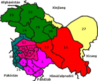
Jammu (Magenta, 1-5) as seen in the map of Jammu and Kashmir.
Jammu is the most populous district in the Indian state of Jammu and Kashmir and is home to the winter capital (Jammu) of Jammu and Kashmir. (The capital moves to Srinagar city in the summer).[2] The largest city is Jammu.
As of 2011 it is the most populous district of Jammu and Kashmir (out of 22).[1]

Bahu Fort, Jammu, India
Administrative divisions
Jammu District is divided into four tehsils: Akhnoor, Bishnah, Jammu and Ranbirsingh Pora.[3]
Religion
Hinduism is the predominant religion in Jammu 84.27%,followed by the vast majority. Other religions include Sikhism, Islam 7.03%, Christianity etc.
Language
| Rank | Language | 1971[5] |
|---|---|---|
| 1 | Dogri | 74.51% |
| 2 | Punjabi | 13.09% |
| 3 | Hindi | 6.45% |
| — | Other | 5.95% |
References
- 1 2 "District Census 2011". Census2011.co.in. 2011. Retrieved 2011-09-30.
- ↑ 2011 census J&K
- ↑ "Jammu District having Tehsil and Village Boundaries". Jammu District. Archived from the original on 16 April 2015.
- ↑ http://www.census2011.co.in/census/district/639-jammu.html
- ↑ General, India Office of the Registrar; Zutshi, J. N. (1 January 1972). "Census of India, 1971: Series 8: Jammu & Kashmir". Manager of Publications – via Google Books.
External links
 |
Reasi district | Ramban district | Udhampur district | |
| Jammu district | |
|||
| ||||
| | ||||
| Samba district | Kathua district |
This article is issued from Wikipedia - version of the 10/16/2016. The text is available under the Creative Commons Attribution/Share Alike but additional terms may apply for the media files.