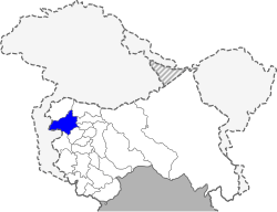
Baramulla district
| Baramulla district | |
|---|---|
| District | |
|
Gulmarg ski resort | |
 Baramulla district | |
| Coordinates: 34°11′53″N 74°21′49″E / 34.1980°N 74.3636°ECoordinates: 34°11′53″N 74°21′49″E / 34.1980°N 74.3636°E | |
| Country |
|
| State | Jammu and Kashmir |
| Headquarters | Baramulla |
| Area | |
| • Total | 3,353 km2 (1,295 sq mi) |
| Population (2011) | |
| • Total | 1,015,503 |
| • Density | 305/km2 (790/sq mi) |
| Languages | |
| • Official | Urdu |
| Time zone | IST (UTC+5:30) |
| Vehicle registration | JK05 |
| Website | http://baramulla.nic.in/ |
Baramulla district is one of the 22 districts in the Indian state of Jammu and Kashmir. Baramulla city is the administrative headquarters of this district. The district covered an area of 4,190 km² in 2001 but it was reduced to 3,353 km² at the time of 2011 census.[1]
Etymology
The name Baramulla, meaning "Boar's Molar Place,"[2] is derived from two Sanskrit words Varaha (Boar) and Mula. According to Hindu teaching, the Kashmir Valley was once a lake called Satisaras, the lake of Parvati (consort of Shiva). The ancient Hindu texts state that the lake was occupied by a demon, Jalodbhava, until Lord Vishnu assumed the form of a boar and struck the mountain with his molar at Baramulla (ancient Varahamula). He bored an opening in it where the lake water flowed out.[3]
History
Ancient and medieval
The city of Baramulla, from which the district derives its name, was founded by Raja Bhimsina in 2306 BCE.
A number of prominent visitors have travelled to Baramulla. These include the famous Chinese visitor Heiun T'Sang and the British historian, Moorcraft. Mughal emperors had a special fascination for Baramulla. As the gateway of the Kashmir Valley, Baramulla was a stopping place for them during their visits to the valley. Jahangir also stayed at Baramulla during his visit to Kashmir in 1620 CE.
From the very beginning, Baramulla has been a religious center. The construction of Hindu Teerth and Buddhist Vihars made the city sacred to people of both religions. In the 15th century, the noted Muslim saint, Syed Janbaz Wali, visited the valley along with his companions in 1421 CE. He chose Baramulla as the centre of his mission and was buried here after death. His shrine attracts pilgrims from all over the Valley. In 1894, the sixth Sikh Guru Shri Hargobind visited the city. Baramulla thus became an abode of Hindus, Muslims, Buddhists and Sikhs living in harmony and contributing to a rich composite culture.[4]
It was the oldest and the most important town in the north of princely state of Kashmir and Jammu. In the later centuries, until 27 October 1947, it was the 'Gateway of Kashmir Valley' by the Rawalpindi-Murree-Muzaffarabad-Baramulla Road. It became a part of Union of India when the Maharaja, under duress of invasion by Pakistani tribal forces, signed the instrument of accession on 26 October 1947, which was accepted by India the next day.
Atrocities in October 1947
On 2 October 1947, the Working Committee of the National Conference met under Sheikh Mohammad Abdullah's presidency and decided to support the accession to India, but Maharaja Hari Singh wanted to remain independent.
A large number of tribals from Pakistan attacked Kashmir under the code name "Operation Gulmarg," intending to seize Kashmir. The invading tribals started moving along Rawalpindi-Murree-Muzaffarabad-Baramulla Road on 22 October 1947 with Pakistani army men in plain clothes. Muzaffarabad fell on 24 October 1947. They reached and captured Baramulla on 25 October. There they stayed for several days looting, raping, and killing residents; burning and plundering homes and businesses; and desecrating and vandalising shrines and temples. They could have reached Srinagar, just 50 km away, and captured its airfield, which was not defended at all. They raped and killed European nuns (only one survived) at Baramulla's St. Joseph convent and Christian nurses at the missionary hospital. This looting, raping, murder and abduction of girls continued for several days.[5] It is said that the suffering of Baramulla saved the rest of Kashmir, because airplanes carrying Indian troops airlifted from Delhi on the morning of 27 October could land at Srinagar airfield while the invaders were still at Baramulla.
Charles Chevenix Trench writes in his The Frontier Scouts (1985):
In October 1947... tribal lashkars hastened in lorries - undoubtedly with official logistic support - into Kashmir... at least one British Officer, Harvey-Kelly took part in the campaign. It seemed that nothing could stop these hordes of tribesmen taking Srinagar with its vital airfield. Indeed nothing did, but their own greed. The Mahsuds in particular stopped to loot, rape and murder; Indian troops were flown in and the lashkars pushed out of the Vale of Kashmir into the mountains. The Mahsuds returned home in a savage mood, having muffed an easy chance, lost the loot of Srinagar and made fools of themselves.
Tom Cooper of Air Combat Information Group wrote:[6]
…the Pathans appeared foremost interested in looting, killing, ransacking and other crimes against the inhabitants instead of a serious military action.
Biju Patnaik (who later became Chief Minister of Odisha) piloted the first plane to land at Srinagar airport that morning. He brought 17 soldiers of 1-Sikh regiment commanded by Lt. Col. Dewan Ranjit Rai.
"...The pilot flew low on the airstrip twice to ensure that no raiders were around... Instructions from PM Nehru’s office were clear: If the airport was taken over by the enemy, you are not to land. Taking a full circle the DC-3 flew ground level. Anxious eye-balls peered from inside the aircraft – only to find the airstrip empty. Nary a soul was in sight. The raiders were busy distributing the war booty amongst them in Baramulla."
In the words of Gen Mohammad Akbar Khan (Brigadier-in-Charge, Pakistan, in his book War for Kashmir in 1947): "The uncouth raiders delayed in Baramulla for two (whole) days for some unknown reason."[7]
It took two weeks for the Indian army to evict the raiders from Baramulla. Joined by Pakistani regular troops, they had become well-entrenched.
Sheikh Mohammad Abdullah spoke in the UN Security Council on 5 February 1948 thus: "...the raiders came to our land, massacred thousands of people — mostly Hindus and Sikhs, but Muslims, too — abducted thousands of girls, Hindus, Sikhs and Muslims alike, looted our property and almost reached the gates of our summer capital, Srinagar..."
Recent years
Roads have been improved and road network has grown considerably in Baramulla town since 1947. New schools and colleges have started and better facilities for education have been created. More bridges on Jhelum river have been constructed or planned to connect the old town on the north bank of the river with the new town on the south bank. Decongestion of the old town has been attempted by moving some residents to houses in the new town.
The most recent development has been creation of railway connectivity with Srinagar, Anantnag and Qazigund and the planned connectivity with Banihal and Jammu.
Administration
Baramulla district comprises sixteen tehsils: Pattan, Uri, Kreeri, Boniyar, Tangmarg, Sopore, Watergam Rafiabad, Rohama, Dangiwacha, Bomai, Dangerpora, Khoie(Panzipora), Wagoora, Kunzer, Kwarhama and Baramulla.
This district consists of 26 blocks: Uri, Rohama, Rafiabad, Zaingeer, Sopore, Boniyar, Baramulla, Tangmarg, Singhpora, Pattan, Wagoora, Kunzer, Paranpillian, Bijhama, Norkhah, Narwav, Nadihal, Kandi Rafiabad, Hardchanum, Tujjar Sharief, Sangrama, Sherabad Khore, Lalpora, Wailoo, Khaipora and Chandil Wanigam.. Pattan tehsil is the largest tehsil of the district Baramulla and was later split to from separate Kreeri tehsil.
Pattan Town is situated in the centre of the district between Srinagar and Baramulla cities and is surrounded by villages like Palhalan, Nihalpora Hanjiwera Zangam, Sherpora, Sonium and Yall.[8] Each block consists of a number of panchayats.
Politics
Baramullah district has seven assembly constituencies: Uri, Rafiabad, Sopore, Sangrama, Baramulla, Gulmarg and Pattan.[9]
Demographics
According to the 2011 census Baramulla district has a population of 1,015,503[10][11] roughly equal to the nation of Cyprus[12] or the US state of Montana.[13] This gives it a ranking of 443rd in India (out of a total of 640).[11] Of the total population, 542,171 (53.4%) were males and 473,332 (46.6%) were females, the sex ratio being 873 females for every 1,000 males,[11] a decrease from 905 in 2001 census, and much lower than the national average of 940. The sex ratio for children in 0 to 6 year age group was even less at 866.
The district has a population density of 305 inhabitants per square kilometre (790/sq mi).[11] Its population growth rate over the decade 2001-2011 was 20.34%.[11] Baramula has a literacy rate of 66.93%.[11] with male literacy 77.35% and female literacy 55.01%. Total literate in Baramula district were 571,348 of which males and females were 352,289 and 219,059 respectively.
Baramulla town is the largest town in the district and the fourth most-populous town in the state, with a population of 167,986 as per 2011 census.
Geography
The district is spread from Srinagar district and Ganderbal district in the east to the line of control in the west, and from Kupwara district in the north and Bandipore district in the northwest to Poonch district in the south and Badgam district in the southwest.
Baramulla city is located on the banks of Jhelum river at the highest point of the river. The old town lies on the north (right) bank of the river and the new town lies on the south (left) bank. They are connected by five bridges, including a suspension bridge connecting Gulnar park with Dewan Bagh. Five more bridges are being constructed or planned. A new bridge will connect Khanpora and Drangbal areas of the City.
The old town is congested and much smaller than the new town. Government offices, civil hospital, district hospital, bus station and most other facilities are situated in the new town. The railway station is on the eastern end of the new town on the left bank of the river.
Past the old town, the Jhelum river divides into two channels at Khadanyar just before police headquarters; it forms an island that has been designated Eco Park. The river flows past Uri town to Muzaffarabad town in Kashmir before crossing into Pakistan.
Economy
Baramulla district is the largest producer of horticulture products in the state. World-class apples are grown here.
Tourism
Gulmarg
Gulmarg village (literally Meadow of Flowers) is a hill station in Baramula district and famous for its skiing slopes at 2,730 m (8,957 ft). It has a cable car for reaching the start of the skiing slope. Gulmarg can be accessed from Srinagar, 50 km (31 mi) to the east.
Some other tourism attractions in Baramulla district are: Tangmarg between Srinagar and Gulmarg, fresh-water lake Wular Lake 60 km (37 mi) from Srinagar; Manasbal Lake (32 km from Srinagar), a bird watching paradise; Manimarg; Vijimarg and Mahalishamarg.
Eco Park
Eco Park, Khadniyar, Baramulla is located at the island in the middle of Jhelum river on the road from Baramulla town to Uri. It is approached by a wooden bridge. In has been recently developed by J&K Tourism Development Corporation with a blend of modern substructure and natural exquisiteness. It offers a great view with mountains in the background, Jhelum river flowing along the island and lush green well-maintained garden with some beautifully designed wooden huts. It is one of the best places to visit in the Baramulla and is a famous destination of locals particularly in summer evenings. Some tourists also visit it. A cable car project and expansion of the existing eco park have been planned.[14]
Tourism sites
-

Gulmarg Gondola - The new cable car at Gulmarg
-
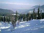
View from the Gulmarg slopes, cable car is used as ski lift
-
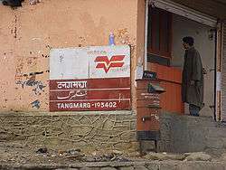
Tangmarg
Education
Baramulla town has a Kendriya Vidyalaya (Central School) and a Sainik (Military) School, both affiliated to the Central Board of Secondary Education. St. Joseph's School, Baramulla, is one of the oldest missionary schools in Kashmir valley. Other private schools include Baramulla Public Hr. Sec. School,Beacon House Baramulla (BHB) Hanfia Model High School Ushkara,Delhi Public School and many schools. There are a number of government-run public schools. Higher Secondary schools are also known as intermediate colleges.
Baramulla town has Govt. Degree College for Boys and Govt. Degree College for Women. The city has a nursing college associated with the district hospital. A medical college and polytechnic college include SSM Pariaspora Pattan Baramulla and also a govt. polytechnic college at Kanispora. Gujjar & Bakerwal (Boys)Hostel Ushkara Baramulla. Two more degree colleges for boys and girls may be started in the city. North campus of University of Kashmir is situated in Baramulla city.
Other towns in the district have schools and colleges.Each town of the district are having 1 or 2 govt. schools.
Healthcare
Baramulla has a district civil hospital and a district veterinary hospital with facilities such as radiology (x-ray) and ultrasonography. The hospital has been shifted to a new building with 300 beds in Kanthbagh in March 2013, ( In the Land of Ushkara Baramulla) which was in construction for two decades. St.Joseph's Hospital & Nursing School run by Christian Missionary Nuns[15] There are smaller hospitals in other towns of the district and primary health centres at villages in the district.Primary Health Center Ushkara Near Jamia Masjid Ushkara under Block Sheeri Ne
Transport
Access to Baramulla
From Srinagar
Baramulla town is located about 55 km (34 mi) from Srinagar, the capital of Jammu & Kashmir state. National Highway NH-1A connects the town to the rest of the country. Taxi and buses to the town are available from Srinagar and Jammu. The nearest airport is at Srinagar. The nearest railhead is Jammu Tawi, about 360 km (224 mi) to the south.
From Uri and Muzaffarabad
The 123 km (76 mi) road from Muzaffarabad to Baramulla is along Jhelum river. It crosses the actual line of control and then passes through Uri town, 45 km (28 mi) to the west of Baramulla town. The first 5 km of the road from Uri to Baramulla is not along the river but the remaining 40 km (25 mi) is along the river and passes through fine scenery of wooded mountains-slopes broken by cliffs that rise to great heights above the path while below it the river either flows in narrow paths or roars over ledges and other obstacles.
Access to Gulmarg
Gulmarg, the famous ski-resort of Kashmir is in Baramulla district. It is reached from Srinagar, 50 km (31 mi) to the east. It is 17 km (11 mi) south of Baramulla town.
Air
Srinagar is the nearest airport, 50 km (31 mi) to the southeast. Jammu, the winter capital of the state also has an airport.
Road
Baramulla is connected to Pattan, Uri, Sopore, Gulmarg, Tangmarg, Watergam and other towns in Baramulla district by road. It is also connected to Srinagar and other towns in Kashmir by road. It is also connected to Muzaffarabad across the line of control by 123 km (76 mi) road that was closed in October 1947 after invasion by Pakistani tribals. The road was reopened in 2005 but the travel across the line of control is highly restricted and controlled.
Railway
Baramulla is the last station on the 119 km (74 mi) long Kashmir railway that started in October 2009 and connects Baramulla to Srinagar and Qazigund. The railway track is connected to Banihal across the Pir Panjal mountains through the newly constructed 11 km long Banihal tunnel in 2012 and finally to Indian railway network at Jammu after a few years.
The most recent development has been creation of railway connectivity with Srinagar, Anantnag and Qazigund and the planned connectivity with Banihal and Jammu.
Language
The commonly used language is Kashmiri, followed by Urdu, Gojri, and Punjabi.[16]
References
- ↑ "About District Baramulla". Retrieved 2016-10-16.
- ↑ The economy of Jammu & Kashmir. Radha Krishan Anand & Co., 2004. Retrieved 2010-07-01.
... meaning in Sanskrit a boar's place. Foreigners who visited this place pronounced ... The place was thus named as Baramulla meaning 12 bores.
- ↑ Kashmir and it's people: studies in the evolution of Kashmiri society. A.P.H. Publishing Corporation. Retrieved 2010-07-01.
That the valley of Kashmir was once a vast lake, known as "Satisaras," the lake of Parvati (consort of Shiva), is enshrined in our traditions. There are many mythological stories connected with the desiccation of the lake, before the valley was fit for habitation. The narratives make it out that it was occupied by a demon 'Jalodbhava,' till Lord Vishnu assumed the form of a boar and struck the mountain at Baramulla (ancient Varahamula) boring an opening in it for the water to flow out.
- ↑ Baramulla: District Profile Archived February 23, 2012, at the Wayback Machine.
- ↑ The Story of Kashmir Affairs - A Peep into the Past
- ↑ Tom Cooper (29 October 2003), Indo-Pakistani War, 1947-1949, Air Combat Information Group, archived from the original on June 13, 2006, retrieved 11 April 2012
- ↑ October 27, 1947: Dakota in my dell ~ FRONTLINE KASHMIR
- ↑ Statement showing the number of blocks in respect of 22 Districts of Jammu and Kashmir State including newly Created Districts Archived September 10, 2008, at the Wayback Machine. dated 2008-03-13, accessed 2008-08-30
- ↑ "ERO's and AERO's". Chief Electoral Officer, Jammu and Kashmir. Retrieved 2008-08-28.
- ↑ Baramula Population Census 2011, Baramula, Jammu and Kashmir literacy sex ratio and density
- 1 2 3 4 5 6 "District Census 2011". Census2011.co.in. 2011. Retrieved 2011-09-30.
- ↑ US Directorate of Intelligence. "Country Comparison:Population". Retrieved 2011-10-01.
Cyprus 1,120,489 July 2011 est.
- ↑ "2010 Resident Population Data". U. S. Census Bureau. Archived from the original on October 19, 2013. Retrieved 2011-09-30.
Montana 989,415
- ↑ "Archived copy". Archived from the original on 2012-06-09. Retrieved 2012-03-27.
- ↑ http://www.tribuneindia.com/2013/20130330/kashmir.htm#2
- ↑ S.C. Bhatt; Gopal Bhargava. Land and People of Indian States and Union Territories. Retrieved 2010-07-01.
As most of these Hindi albeit Gujari speakers have been shown as concentrated in Baramulla, Kupwara, Punch, Rajouri and Doda districts, their Gujar identity becomes obvious. The number of Punjabi speakers in 1961, 1971 and 1981 Census Reports, actually reflects the number of Sikhs who have maintained their language and culture, and who are concentrated mainly in Srinagar, Badgam, Tral, Baramulla (all in Kashmir region), Udhampur and Jammu.
External links
| Wikimedia Commons has media related to Baramulla district. |
- List of places in Baramulla
- Baramulla district official website
- Baramulla Kite Festival 2013
 |
Kupwara district | Bandipore district | | |
| |
|
Ganderbal district Srinagar district | ||
| ||||
| | ||||
| Poonch district | Badgam district |