Inveresk
| Inveresk | |
| Scottish Gaelic: Inbhir Easg | |
 St. Michael's Parish Church, Inveresk |
|
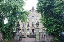
 Inveresk |
|
| OS grid reference | NT346719 |
|---|---|
| Civil parish | Inveresk |
| Council area | East Lothian |
| Lieutenancy area | East Lothian |
| Country | Scotland |
| Sovereign state | United Kingdom |
| Post town | MUSSELBURGH |
| Postcode district | EH21 |
| Dialling code | 0131 |
| Police | Scottish |
| Fire | Scottish |
| Ambulance | Scottish |
| EU Parliament | Scotland |
| UK Parliament | East Lothian |
| Scottish Parliament | East Lothian |
Coordinates: 55°56′13″N 3°02′49″W / 55.937°N 3.047°W


Inveresk (Gaelic: Inbhir Easg) is a village in East Lothian, Scotland situated immediately to the south of Musselburgh. It has been designated a conservation area since 1969. It is situated on slightly elevated ground on the north bank of a loop of the River Esk. This ridge of ground, 20 to 25 metres above sea level, was used by the Romans as the location for a fort in the 2nd century AD.[1]
The element "Inver", from the Gaelic inbhir, refers to the confluence of the river Esk with the Firth of Forth.[2]
The village was formerly in the Midlothian parish of the same name and developed distinctly from the separate burgh of Musselburgh.
Inveresk is notable for its fine street of 17th- and 18th-century houses. Inveresk Lodge is now privately leased, but the adjacent Inveresk Lodge Garden belongs to the National Trust for Scotland, and its west facing gardens overlooking the river Esk are open to the public. This was formerly the mansion of James Wedderburn who had made his fortune as a slave-owning sugar plantation owner in Jamaica. When his son by one of his slaves, Robert Wedderburn, travelled to Inveresk to claim his kinship he was insultingly rejected by his father who gave him some small beer and a broken or bent sixpence. This experience turned Robert Wedderburn to radicalism.
St. Michael's Church
The village is dominated by St. Michaels church that stands at its west end on the summit of the local hill overlooking Musselburgh. Its graveyard/cemetery stretches westwards for almost 300m and is split into separate walled sections (marking its various stages of extension) which can be broadly bracketed as original (mainly 18th century), a late Victorian extension, an Edwardian/ early 20th century extension to the north, and a modern section to the far west.
The current church is by Robert Nisbet and dates to 1805 and has a stone spire of Wren-influence but is believed to date to the 6th century.[3]
Noteworthy graves

The graveyard has a number of interesting graves:-
- A white-painted, cast-iron sculpture of a coffin draped in military regalia, atop a full-sized cannon and cannon-balls, just south of the church marking the grave of Major William Norman Ramsay of Waterloo fame (see separate article Order of battle of the Waterloo Campaign)
- A monument to 7 fishermen from Fisherrow of the fishing-boat "Alice of Boddam", lost in the storm of 14 October 1881 (generally referred to as the Eyemouth Disaster).
- Very Rev Alexander Carlyle (1722-1805)
- Curious cubic gravestones to Admiral Archibald Cochran (d.1843) and his son Admiral Thomas Cochran (d.1888)
- Rev William Lindsay Alexander (1808-1884)
- John Cran, shipbuilder (1849-1940)
- The Buller-Elphinstone tomb: William Elphinstone, 15th Lord Elphinstone, Sidney Elphinstone, 16th Lord Elphinstone (a sarcophagus-style monument at the east end of the Victorian section)
- James Greenlees (1870-1951) rugby player and scholar, headmaster of Loretto College 1926-41 (a atone on the west wall of the Victorian section)
- A large monument to several of Hope Baronets of Craighall (against the far east wall)
- Major General Sir Patrick Lindesay (1778-1839), military hero, Acting Governor of New South Wales in 1831 (stone fully obscured by yew trees)
- John Grieve: John Grieve was awarded the Victoria Cross for his bravery at the Battle of Balaklava in the Crimean War.
- Admiral Sir David Milne 1763-1845, his son Admiral Sir Alexander Milne 1806-1896 and his geologist son David Milne-Home 1805-1890
- David Rae, Lord Eskgrove (1724-1804) (on the outer south-west corner of the church)
- Sir William Rae, 3rd Baronet (1769-1842) son of the above, buried with his father
- Alexander Handyside Ritchie sculptor (1804-1870)
- The Wedderbrn tomb: Sir David Wedderburn, 1st Baronet (1775-1858), Sir John Wedderburn, 2nd Baronet, Sir David Wedderburn, 3rd Baronet (1835-1882)
Other notable persons linked to Inveresk
- Angus Fulton (engineer) 1900-1983, died here
- James Murray, 2nd Duke of Atholl, buried here.
- Robert Mylne, architect/master mason, 1633-1710, lived and died here
- Clarissa Dickson Wright the chef and broadcaster lived here until her death in March 2014.[4]
- Henry Yule (1820-1899), Scottish Orientalist, born here
References
- ↑ Burnet,JEM (1999) A reason for Inveresk. Courtyard Press, Inveresk. ISBN 0-9537450-0-7
- ↑ Dixon, Norman. "The Placenames of Midlothian" (PDF). Retrieved 2012-07-04. "'The mouth of the R. Esk' v. G. inbhir, inbhear: 'the confluence of a stream with the sea.'"
- ↑ McWilliam, Colin (1978). Buildings of Scotland Lothian except Edinburgh. Penguin Books.
- ↑ Dickson Wright, Clarissa (2012). Clarissa's England: A gamely gallop through the English counties. Hodder & Stoughton. ISBN 9781444729139.
External links
| Wikimedia Commons has media related to Inveresk. |
- Canmore - Inveresk, Musselburgh, Roman Fort site record
- Workhouses - Inveresk
- Scottish Places - Inveresk
