Interstate 82
| |||||||
|---|---|---|---|---|---|---|---|
|
Interstate 82 highlighted in red | |||||||
| Route information | |||||||
| Maintained by WSDOT and ODOT | |||||||
| Length: | 143.58 mi[1][2][3] (231.07 km) | ||||||
| Existed: | 1956[4] – present | ||||||
| Major junctions | |||||||
| West end: |
| ||||||
|
| |||||||
| East end: |
| ||||||
| Location | |||||||
| States: | Washington, Oregon | ||||||
| Highway system | |||||||
| |||||||


Interstate 82 (I-82) is a 143.58-mile (231.07 km) Interstate Highway in the northwest United States, extending from I-90 in Ellensburg, Washington, to I-84 near Umatilla, Oregon.
In Washington, it serves the cities of Ellensburg, Yakima, and the Tri-Cities (via I-182), and in Oregon, it serves Umatilla and Hermiston. Constructed from 1969 to 1987, it is the major route westwards to Seattle and eastwards to Boise and Salt Lake City (via I-84 and I-15).[5][6][7][8] I-82's designation is a violation of the Interstate system's numbering rules, as it is located north of I-84, and is also primarily a north-south route. I-84 was originally designated I-80N, but received its current number in 1980 as part of efforts to eliminate suffixed routes.[9][10]
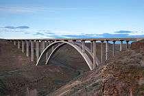
I-82 passes over Selah Creek on the Fred G. Redmon Bridge. At its opening 45 years ago on November 2, 1971, it was the longest concrete arch bridge in North America.[11][12] The bridge spans 549 feet (167 m) across the creek.[11][12]
In 1999, a plan surfaced to extend the Interstate down south through Oregon. Three routes were proposed but all were rejected.[13][14]
Route description
| mi | km | |
|---|---|---|
| WA | 132.57[2] | 213.35 |
| OR | 11.01[3] | 17.72 |
| Total | 143.58[1] | 231.07 |
I-82 starts at an interchange with I-90 and U.S. Route 97 (US 97) in Ellensburg.[15] At this point, I-82/US 97 start heading southeast towards Yakima, on roadbed graded and constructed from 1969 to 1971.[16][17][18] (US 97 was previously routed through the serpentine Yakima River canyon, today's State Route 821 (SR 821).) Before entering Yakima, I-82/US 97 intersects SR 821 and State Route 823 (SR 823) while passing the Yakima Firing Center.

Just north of Selah, the freeway passes over Selah Creek on the Fred G. Redmon Bridge, the longest concrete arch in North America at the time of its opening, spanning 549 feet (167 m) across the creek.[11][12] From the bridge, I-82/US 97 passes from Selah into Yakima.[15] In Yakima, I-82/US 97 join US 12 and intersect SR 24.[15] After leaving Yakima and Union Gap, US 97 splits from I-82/US 12. I-82 then enters the Yakama Indian Reservation as it starts turning eastward towards the Tri-Cities. West of Toppenish, I-82/US 12 intersects SR 22, and then goes east past Zillah and into Granger, where it intersects SR 223.[19][20][21][22]
After leaving both Granger and the Yakama Indian Reservation, the freeway continues east to Sunnyside, where the highway intersects SR 241. Then, I-82/US 12 turns southeast to pass Grandview and reach Prosser, where SR 22 intersects the freeway.[15] From Prosser, the highway turns northeast into Benton City, where SR 224 and SR 225 intersect I-82/US 12. From Benton City, the freeway goes eastward towards Richland, when I-182 starts and US 12 joins I-182 into Richland.[23] From the interchange, I-82 goes southeast around the Tri-Cities and joins US 395.[24] After joining US 395, the freeway goes south and then west into Plymouth, where the highway intersects SR 14 and leaves Washington on the Umatilla Bridge over the Columbia River heading into Oregon.[15][25] [26] The original bridge of 1955 carries eastbound traffic (south over the river) and the newer 1988 bridge goes westbound (north over the river).
After crossing the bridge into Oregon, I-82/US 395 enter Umatilla, where US 395 exits off at the intersection with US 730. After leaving Umatilla, the highway goes southwest and passes the Umatilla Ordnance Depot before ending at I-84/US 30 southwest of Hermiston.[27][28][29]
History
As part of Washington's first connected state highway system, the Washington State Legislature designated the Inland Empire Highway between Ellensburg and Laurier in 1913.[30] The State Highway Board selected a route that would connect the main cities of Eastern Washington and the Inland Empire, which were Ellensburg, Yakima, the Tri Cities, Colfax, and Spokane.[31][32] In 1923, by which time the entire road had been improved,[33] the highway became State Road 3 (Primary State Highway 3 and Primary State Highway 3 WA after 1937), but retained its name.[34] By that time, most of the route of Interstate 82 became parts of US 410, US 97, and US 395, all three were established in 1926.[35][36][37]

In 1956, President Dwight D. Eisenhower signed the Federal Aid Highway Act of 1956, which started the construction of Interstate Highways.[38][39] Even though I-82 was designated in 1956, construction did not start until March 1969,[18] and the last section of within Washington opened in 1987.[40] Legally, the Washington section of I-82 is defined at Washington Revised Code § 47.17.135.[4] Several projects are currently ongoing and have been completed in the recent years on I-82.[41]
I-82 was meant to go from Tacoma, across Naches Pass, and then southeast into Yakima and the Tri-Cities. The proposal was quickly denied and later resurfaced as the SR 168 Proposal.[42]
The original plans for the included two options. One was the current route (which was opposed by the Tri-Cities), and another had I-82 go from Prosser into Richland and Pasco, and then southeast to Wallula and then end at I-80N (present-day I-84) in Pendleton. The first option was chosen, but the Tri-Cities needed access, so the Federal Highway Administration created Interstate 182, which would serve as a connector from I-82 to the Tri-Cities.[43][44] [45]
When I-80N was renumbered I-84 in 1980, I-82's designation became a violation of the Interstate system's numbering rules, as it was now located north of I-84. The reason for the renumbering was a change in guidelines published by the American Association of State Highway and Transportation Officials that advised renumbering suffixed routes.[9][10] In 1999, a plan surfaced to extend I-82 further south in Oregon. Three major routes were proposed including the Madras Route, from Umatilla through Heppner, Condon, Fossil, and Antelope to Madras, where I-82 would replace US 97 south through Bend to the California border, the Prineville route, from Umatilla through Heppner, Hardman, Spray, Prineville, and Powell Butte to US 97 near Bend, then continue south to the border, and the US 395 route, from Umatilla through John Day, Burns, and Lakeview, presumably to the California border and beyond.[13][14]
Exit list
| State | County | Location | mi[2][3] | km | Exit | Destinations | Notes |
|---|---|---|---|---|---|---|---|
| Washington | Kittitas | | 0.00 | 0.00 | — | Westbound exit and eastbound entrance; western terminus; I-90 exit 110; trumpet interchange. | |
| | 3.22 | 5.18 | 3 | ||||
| | 11.62 | 18.70 | 11 | Military Area | Serves Yakima Training Center | ||
| Yakima | | 26.56 | 42.74 | 26 | |||
| | 28.99 | 46.65 | 29 | East Selah Road | |||
| | 30.59 | 49.23 | 30 | Signed as exits 30A (SR 823) and 30B (Rest Haven Road) westbound | |||
| Yakima | 31.35 | 50.45 | 31 | West end of US 12 overlap; signed as exits 31A (US 12) and 31B (1st Street) eastbound | |||
| 33.21 | 53.45 | 33A | Fair Avenue, Lincoln Avenue | Eastbound exit and entrance | |||
| 33.21 | 53.45 | 33B | Yakima Avenue – Terrace Heights | Signed as exit 33 westbound | |||
| 34.74 | 55.91 | 34 | |||||
| Union Gap | 36.26 | 58.35 | 36 | Valley Mall Boulevard – Union Gap | |||
| | 37.81 | 60.85 | 37 | East end of US 97 overlap; eastbound exit and westbound entrance | |||
| | 38.07 | 61.27 | 38 | Union Gap | Westbound exit and eastbound entrance | ||
| | 40.31 | 64.87 | 40 | Thorp Road, Parker Road | |||
| | 44.29 | 71.28 | 44 | Wapato | |||
| | 50.08 | 80.60 | 50 | ||||
| Zillah | 52.05 | 83.77 | 52 | Zillah, Toppenish | |||
| 54.05 | 86.99 | 54 | Division Road – Zillah | ||||
| Granger | 58.47 | 94.10 | 58 | ||||
| Sunnyside | 63.61 | 102.37 | 63 | Sunnyside, Outlook | |||
| 66.90 | 107.67 | 67 | Sunnyside, Mabton | ||||
| 68.91 | 110.90 | 69 | |||||
| Grandview | 72.58 | 116.81 | 73 | Stover Road – Grandview | |||
| 75.02 | 120.73 | 75 | County Line Road – Grandview | ||||
| Benton | Prosser | 79.90 | 128.59 | 80 | Gap Road – Prosser | ||
| 82.31 | 132.47 | 82 | |||||
| | 88.52 | 142.46 | 88 | Gibbon Road | |||
| | 93.58 | 150.60 | 93 | Yakitat Road | |||
| Benton City | 96.55 | 155.38 | 96 | ||||
| | 102.48 | 164.93 | 102 | East end of US 12 overlap | |||
| | 104.49 | 168.16 | 104 | Dallas Road | |||
| | 108.91 | 175.27 | 109 | Badger Road | |||
| | 112.76 | 181.47 | 113 | West end of US 395 overlap | |||
| | 114.36 | 184.04 | 114 | ||||
| | 122.70 | 197.47 | 122 | Coffin Road | |||
| | 131.55 | 211.71 | 131 | ||||
| Columbia River | 132.57 0.00 | 213.35 0.00 | Umatilla Bridge Washington–Oregon state line | ||||
| Oregon | Umatilla | Umatilla | 1.00 | 1.61 | 1 | East end of US 395 overlap | |
| | 4.83 | 7.77 | 5 | Power Line Road | |||
| | 9.79 | 15.76 | 10 | Westland Road | |||
| | 11.21 | 18.04 | — | Eastbound exit and westbound entrance; eastern terminus; I-84 exit 179 (OR) | |||
1.000 mi = 1.609 km; 1.000 km = 0.621 mi
| |||||||
Auxiliary routes
References
- 1 2 Federal Highway Administration (October 31, 2002). "Route Log and Finder List, Main Routes of the Dwight D. Eisenhower National System Of Interstate and Defense Highways". Retrieved August 27, 2008.
- 1 2 3 Washington State Department of Transportation (2006). "State Highway Log" (PDF). Retrieved August 27, 2008.
- 1 2 3 Oregon Department of Transportation. "Public Road Inventory". Retrieved August 27, 2008.
- 1 2 Washington State Legislature. "RCW 47.17.135: State route No. 82 — Washington green highway". Retrieved August 10, 2008.
- ↑ Google (August 22, 2008). "overview map of I-82" (Map). Google Maps. Google. Retrieved August 22, 2008.
- ↑ Official State Highway Map (PDF) (Map) (2008-2009 ed.). 1:842,000. Official State Highway Maps. Cartography by U.S. Geological Survey. Olympia, Washington: Washington State Department of Transportation. 2008. Retrieved August 7, 2008.
- ↑ Washington Large Print (Map) (2007 ed.). GM Johnson Large Print State Maps. Burnaby, British Columbia: GM Johnson. 2007. Retrieved August 8, 2008.
- ↑ Oregon Large Print (Map) (2007 ed.). GM Johnson Large Print State Maps. Burnaby, British Columbia: GM Johnson. 2007. Retrieved August 8, 2008.
- 1 2 "Highway Resolutions - Interstate 84". Utah Department of Transportation. Retrieved May 18, 2008.
- 1 2 "Interstate 80 to become 84". Deseret News. August 13, 1977. pp. A3. Retrieved September 21, 2008.
- 1 2 3 HistoryLink (March 7, 2005). "Fred Redmon Bridge (Selah Creek Bridge) opens on November 2, 1971". Retrieved August 27, 2008.
- 1 2 3 Washington State Department of Transportation. "WSDOT - History of WSDOT (1978-1990)". Retrieved September 9, 2008.
- 1 2 Sinks, James. "Eastern Oregon waits for new highway". The Bulletin.
- 1 2 Oregon Department of Transportation. "Interstate 50th Anniversary: The Story of Oregon's Interstates" (PDF). Retrieved August 24, 2008.
- 1 2 3 4 5 The Road Atlas (Map). Rand McNally. 2008. p. 108. ISBN 0-528-93961-0.
- ↑ "Construction of I-82 link to Yakima appears closer". Ellensburg Daily Record. January 10, 1969. p. 1.
- ↑ Olds, Virginia (May 27, 1970). "I-82 crosses virgin territory southward from Ellensburg". Ellensburg Daily Record. p. 1.
- 1 2 "I-82 to open six months early". Ellensburg Daily Record. August 8, 1970. p. 1.
- ↑ Google (August 23, 2008). "overview map of I-82 (Ellensurg to Granger)" (Map). Google Maps. Google. Retrieved August 23, 2008.
- ↑ The Road Atlas (Map). Rand McNally. 2008. p. 108. § K12. ISBN 0-528-93961-0.
- ↑ Yakima, Yakima County Wineries (Map) (2008 ed.). City Street Map. Burnaby, British Columbia: GM Johnson. 2008. Retrieved August 8, 2008.
- ↑ Washington State Department of Transportation. "WSDOT Interchange Viewer - Interstate 82 (Exit 3 to 54)". Retrieved August 10, 2008.
- ↑ The Road Atlas (Map). Rand McNally. 2008. p. 108. § K14. ISBN 0-528-93961-0.
- ↑ Tri-Cities, Kennewick, Pasco, Richland (Map) (2007 ed.). City Street Map. Burnaby, British Columbia: GM Johnson. 2007. Retrieved August 8, 2008.
- ↑ Google (August 23, 2008). "overview map of I-82 (Granger to Plymouth)" (Map). Google Maps. Google. Retrieved August 23, 2008.
- ↑ Washington State Department of Transportation. "WSDOT Interchange Viewer - Interstate 82 (Exit 58-131)". Retrieved August 10, 2008.
- ↑ Google (August 23, 2008). "overview map of I-82 (Umatilla to Hermiston)" (Map). Google Maps. Google. Retrieved August 23, 2008.
- ↑ The Road Atlas (Map). Rand McNally. 2008. p. 84. § C11. ISBN 0-528-93961-0.
- ↑ Walla Walla, Hermiston, Pendleton (Map) (2008 ed.). City Street Map. Burnaby, British Columbia: GM Johnson. 2008. Retrieved August 8, 2008.
- ↑ Washington State Legislature (1913) [1913]. "65". Session Laws of the State of Washington. Session Laws of the State of Washington (1913 ed.). Olympia, Washington: Washington State Legislature. p. 221. Retrieved August 10, 2008.
- ↑ Road Map of Washington Showing Main Traveled Roads (Map). State Highway Board. 1912. Retrieved August 26, 2008.
- ↑ Map of Washington State Highways Authorized by Legislative Acts of 1913 (with 1915 changes marked) (Map). State Highway Board. Retrieved August 26, 2008.
- ↑ Official 1923 Auto Trails Map, District No. 14: Washington, Oregon, Northern California, Western Idaho (Map). Rand McNally. Retrieved August 26, 2008.
- ↑ Washington State Legislature (1923) [1923]. "185". Session Laws of the State of Washington. Session Laws of the State of Washington (1923 ed.). Olympia, Washington: Washington State Legislature. pp. 627–628. Retrieved August 10, 2008.
- ↑ Bureau of Public Roads & American Association of State Highway Officials (November 11, 1926). United States System of Highways Adopted for Uniform Marking by the American Association of State Highway Officials (Map). 1:7,000,000. Washington, DC: U.S. Geological Survey. OCLC 32889555. Retrieved November 7, 2013 – via University of North Texas Libraries.
- ↑ Highway Map: State of Washington (Map). Department of Highways. April 1, 1933. Retrieved August 26, 2008.
- ↑ Rand McNally (1939). Highways of the State of Washington (Map). Department of Highways. Retrieved August 26, 2008.
- ↑ United States Department of Transportation/Federal Highway Administration (July 7, 2006). "The Greatest Decade 1956-1966 Part 1 Essential to the National Interest". Retrieved August 11, 2008.
- ↑ United States Department of Transportation/Federal Highway Administration. "History of the Interstate Highway System". Retrieved August 11, 2008.
- ↑ Washington State Department of Transportation. "WSDOT - History of WSDOT (1978-1990)". Retrieved August 11, 2008.
- ↑ Washington State Department of Transportation. "WSDOT - Construction Projects on Interstate 82". Retrieved August 11, 2008.
- ↑ Washington State Legislature. "RCW 47.17.335: State route No. 168". Retrieved September 9, 2008.
- ↑ Interstate Highway System (1963) (Map). United States Department of Transportation and Federal Highway Administration. 1963. Retrieved September 9, 2008.
- ↑ Interstate Highway System (1970) (Map). United States Department of Transportation and Federal Highway Administration. October 1, 1970. Retrieved September 9, 2008.
- ↑ Interstate Highway System (1976) (Map). United States Department of Transportation and Federal Highway Administration. September 30, 1976. Retrieved September 9, 2008.
External links
| Wikimedia Commons has media related to Interstate 82. |
| Signed | |||||||||||
|---|---|---|---|---|---|---|---|---|---|---|---|
| Unsigned | |||||||||||
| Lists |
| ||||||||||
Major Interstates highlighted | |||||||||||