Hustonville, Kentucky
| Hustonville, Kentucky | |
|---|---|
| City | |
 Location of Hustonville, Kentucky | |
| Coordinates: 37°28′22″N 84°49′4″W / 37.47278°N 84.81778°WCoordinates: 37°28′22″N 84°49′4″W / 37.47278°N 84.81778°W | |
| Country | United States |
| State | Kentucky |
| County | Lincoln |
| Established | 1836 |
| Incorporated | 1850 |
| Area | |
| • Total | 0.6 sq mi (2 km2) |
| • Land | 0.6 sq mi (2 km2) |
| • Water | 0.0 sq mi (0 km2) |
| Elevation | 984 ft (300 m) |
| Population (2000) | |
| • Total | 347 |
| • Density | 628.9/sq mi (242.8/km2) |
| Time zone | Eastern (EST) (UTC-5) |
| • Summer (DST) | EDT (UTC-4) |
| ZIP code | 40437 |
| Area code(s) | 606 |
| FIPS code | 21-38836 |
| GNIS feature ID | 0494855 |
Hustonville is a 5th-class city in Lincoln County, Kentucky, in the United States. The population was 347 at the 2000 census. It is part of the Danville Micropolitan Statistical Area.
History
The community was originally known as The Crossroads from its location on trails connecting the Kentucky and Green rivers and the Falls of the Ohio with Logan's Fort (present-day Stanford). It was then known as Farmington and, after the 1818 erection of a post office, Hanging Fork after a local stream named for two bandits who were hanged by Virginia officers rather than escorted back for trial. For three months in 1826, it was known as New Store, but the name then returned to Hanging Fork. When the town was established on February 29, 1836, it was renamed Hustonville after two local landowners; the post office adopted the name the next year.[1] The city was formally incorporated by the state assembly in 1850.[2]
"The church at Hustonville having no suitable house of worship, [William Logan Williams] raised a sufficient fund--six thousand dollars--to build the present commodious edifice, which stands to-day as a monument to his energy and liberality. It was dedicated in 1855 by H. T. Anderson. Encouraged by this success, [Williams] entered the field again to raise funds to build a college to be under the control of the church. In a short time he secured twelve thousand dollars with which was erected Christian College, a handsome brick structure about one hundred feet long by fifty feet wide, and three stories in height."[3]
After graduation from Centre College in Danville, Kentucky in 1889, Augustus O. Stanley, who was at one time, member of the US House and Senate, as well as governor of Kentucky, served as chair of belles-lettres at Christian College.[4]
Geography
Hustonville is located at 37°28′22″N 84°49′4″W / 37.47278°N 84.81778°W (37.472800, -84.817669).[5] According to the United States Census Bureau, the city has a total area of 0.6 square miles (1.6 km2), all land.
Demographics
| Historical population | |||
|---|---|---|---|
| Census | Pop. | %± | |
| 1860 | 215 | — | |
| 1870 | 320 | 48.8% | |
| 1880 | 353 | 10.3% | |
| 1890 | 435 | 23.2% | |
| 1900 | 425 | −2.3% | |
| 1910 | 384 | −9.6% | |
| 1920 | 372 | −3.1% | |
| 1930 | 405 | 8.9% | |
| 1940 | 443 | 9.4% | |
| 1950 | 435 | −1.8% | |
| 1960 | 387 | −11.0% | |
| 1970 | 413 | 6.7% | |
| 1980 | 339 | −17.9% | |
| 1990 | 313 | −7.7% | |
| 2000 | 347 | 10.9% | |
| 2010 | 405 | 16.7% | |
| Est. 2015 | 399 | [6] | −1.5% |
As of the census[8] of 2000, there were 347 people, 165 households, and 100 families residing in the city. The population density was 628.9 per square mile (242.8/km2). There were 181 housing units at an average density of 328.0 per square mile (126.6/km2). The racial makeup of the city was 96.83% White, 1.15% African American, 0.29% Asian, and 1.73% from two or more races.
There were 165 households out of which 21.8% had children under the age of 18 living with them, 45.5% were married couples living together, 11.5% had a female householder with no husband present, and 38.8% were non-families. 34.5% of all households were made up of individuals and 19.4% had someone living alone who was 65 years of age or older. The average household size was 2.10 and the average family size was 2.67.
In the city the population was spread out with 17.3% under the age of 18, 6.1% from 18 to 24, 23.3% from 25 to 44, 28.2% from 45 to 64, and 25.1% who were 65 years of age or older. The median age was 46 years. For every 100 females there were 81.7 males. For every 100 females age 18 and over, there were 85.2 males.
The median income for a household in the city was $33,750, and the median income for a family was $45,000. Males had a median income of $29,167 versus $22,917 for females. The per capita income for the city was $16,379. About 9.6% of families and 19.6% of the population were below the poverty line, including 12.2% of those under age 18 and 30.9% of those age 65 or over.
References
- ↑ Rennick, Robert M. (1987). Kentucky Place Names. University Press of Kentucky. p. 147. Retrieved 28 Apr 2013.
- ↑ Commonwealth of Kentucky. Office of the Secretary of State. Land Office. "Hustonville, Kentucky". Accessed 29 Jul 2013.
- ↑ https://books.google.com/books?id=YbPRAAAAMAAJ&dq=The%20church%20at%20Hustonville%20having%20no%20suitable%20house%20of%20worship%2C&pg=PA432#v=onepage&q=The%20church%20at%20Hustonville%20having%20no%20suitable%20house%20of%20worship,&f=false
- ↑ Johnson, E. Polk. A History of Kentucky and Kentuckians: The Leaders and Representative Men in Commerce, Industry and Modern Activities. Chicago, Illinois: Lewis Publishing Company, 1912.
- ↑ "US Gazetteer files: 2010, 2000, and 1990". United States Census Bureau. 2011-02-12. Retrieved 2011-04-23.
- ↑ "Annual Estimates of the Resident Population for Incorporated Places: April 1, 2010 to July 1, 2015". Retrieved July 2, 2016.
- ↑ "Census of Population and Housing". Census.gov. Retrieved June 4, 2015.
- ↑ "American FactFinder". United States Census Bureau. Retrieved 2008-01-31.
Municipalities and communities of Lincoln County, Kentucky, United States | ||
|---|---|---|
| Cities | 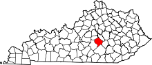 | |
| Unincorporated communities | ||
| Footnotes | ‡This populated place also has portions in an adjacent county | |