Fulton County, Kentucky
| Fulton County, Kentucky | |
|---|---|
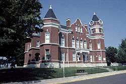 Fulton County Courthouse in Hickman | |
 Location in the U.S. state of Kentucky | |
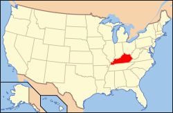 Kentucky's location in the U.S. | |
| Founded | 1845 |
| Named for | Robert Fulton |
| Seat | Hickman |
| Largest city | Fulton |
| Area | |
| • Total | 231 sq mi (598 km2) |
| • Land | 206 sq mi (534 km2) |
| • Water | 25 sq mi (65 km2), 11% |
| Population | |
| • (2010) | 6,813 |
| • Density | 33/sq mi (13/km²) |
| Congressional district | 1st |
| Time zone | Central: UTC-6/-5 |
| Website |
www |
Fulton County is the westernmost county of the U.S. state of Kentucky, with its western boundary the Mississippi River. As of the 2010 census, the population was 6,813.[1] Its county seat is Hickman.[2] The county was formed in 1845 from Hickman County, Kentucky and named for Robert Fulton, the inventor of the steamboat.[3][4]
Fulton County residents were largely pro-Confederate during the American Civil War. Forces from both armies passed through the county during different periods of the conflict.[5] Because of imprecise early surveying of Kentucky's southern border, Fulton County is divided into two non-contiguous parts. An exclave on the peninsula in the Kentucky Bend of the Mississippi River can be reached only by road through Tennessee.
Fulton County is part of the Union City, TN–KY Micropolitan Statistical Area, which is included in the Martin-Union City, TN-KY Combined Statistical Area.

Geography
According to the U.S. Census Bureau, the county has a total area of 231 square miles (600 km2), of which 206 square miles (530 km2) is land and 25 square miles (65 km2) (11%) is water.[6]
About 11 square miles (28 km2) of the county is separated in a peninsula from the rest of the state by an oxbow of the Mississippi River, known as the Kentucky Bend or New Madrid Bend, after the city in Missouri on the north side of the river. Travelers going there have to pass into Tennessee by road (there is no bridge from Missouri) and then go north to reach the Kentucky Bend exclave. The lowest point in the state of Kentucky is located on the Mississippi River in Kentucky Bend in Fulton County, where it flows past Kentucky and between Tennessee and Missouri. It is expected that over time, the river will cut across the short neck of the peninsula, cutting it off entirely from Kentucky, with land gradually filling in behind it to connect it to Missouri.
Adjacent counties
- Mississippi County, Missouri (northwest)
- Hickman County (northeast)
- Obion County, Tennessee (south)
- Lake County, Tennessee (southwest)
- New Madrid County, Missouri (west)
National protected area
Major highways
Demographics
| Historical population | |||
|---|---|---|---|
| Census | Pop. | %± | |
| 1850 | 4,446 | — | |
| 1860 | 5,317 | 19.6% | |
| 1870 | 6,161 | 15.9% | |
| 1880 | 7,977 | 29.5% | |
| 1890 | 10,005 | 25.4% | |
| 1900 | 11,546 | 15.4% | |
| 1910 | 14,114 | 22.2% | |
| 1920 | 15,197 | 7.7% | |
| 1930 | 14,927 | −1.8% | |
| 1940 | 15,413 | 3.3% | |
| 1950 | 13,668 | −11.3% | |
| 1960 | 11,256 | −17.6% | |
| 1970 | 10,183 | −9.5% | |
| 1980 | 8,971 | −11.9% | |
| 1990 | 8,271 | −7.8% | |
| 2000 | 7,752 | −6.3% | |
| 2010 | 6,813 | −12.1% | |
| Est. 2015 | 6,238 | [7] | −8.4% |
| U.S. Decennial Census[8] 1790-1960[9] 1900-1990[10] 1990-2000[11] 2010-2013[1] | |||
As of the census[12] of 2000, there were 7,752 people, 3,237 households, and 2,113 families residing in the county. The population density was 37 per square mile (14/km2). There were 3,697 housing units at an average density of 18 per square mile (6.9/km2). The racial makeup of the county was 75.12% White, 23.19% Black or African American, 0.12% Native American, 0.31% Asian, 0.32% from other races, and 0.94% from two or more races. 0.72% of the population were Hispanic or Latino of any race.
There were 3,237 households out of which 29.30% had children under the age of 18 living with them, 44.40% were married couples living together, 18.00% had a female householder with no husband present, and 34.70% were non-families. 32.30% of all households were made up of individuals and 16.20% had someone living alone who was 65 years of age or older. The average household size was 2.32 and the average family size was 2.92.
In the county the population was spread out with 24.90% under the age of 18, 8.90% from 18 to 24, 25.50% from 25 to 44, 23.20% from 45 to 64, and 17.50% who were 65 years of age or older. The median age was 38 years. For every 100 females there were 87.70 males. For every 100 females age 18 and over, there were 82.00 males.
The median income for a household in the county was $24,382, and the median income for a family was $30,788. Males had a median income of $26,401 versus $19,549 for females. The per capita income for the county was $14,309. About 20.10% of families and 23.10% of the population were below the poverty line, including 32.30% of those under age 18 and 16.00% of those age 65 or over.
Education
Media
- WENK-AM 1240 "The Greatest Hits of All Time"
- WWKF-FM 99.3 "Today's Best Music with Ace & TJ in the Morning"
Communities
See also
References
- 1 2 "State & County QuickFacts". United States Census Bureau. Retrieved March 6, 2014.
- ↑ "Find a County". National Association of Counties. Retrieved 2011-06-07.
- ↑ The Register of the Kentucky State Historical Society, Volume 1. Kentucky State Historical Society. 1903. p. 35.
- ↑ Hogan, Roseann Reinemuth (1992). Kentucky Ancestry: A Guide to Genealogical and Historical Research. Ancestry Publishing. p. 235. Retrieved 26 July 2013.
- ↑ "Fulton County, Kentucky Genealogy, Facts, Records & Links". Genealogyinc.com. Retrieved April 16, 2013.
- ↑ "2010 Census Gazetteer Files". United States Census Bureau. August 22, 2012. Retrieved August 14, 2014.
- ↑ "County Totals Dataset: Population, Population Change and Estimated Components of Population Change: April 1, 2010 to July 1, 2015". Retrieved July 2, 2016.
- ↑ "U.S. Decennial Census". United States Census Bureau. Retrieved August 14, 2014.
- ↑ "Historical Census Browser". University of Virginia Library. Retrieved August 14, 2014.
- ↑ "Population of Counties by Decennial Census: 1900 to 1990". United States Census Bureau. Retrieved August 14, 2014.
- ↑ "Census 2000 PHC-T-4. Ranking Tables for Counties: 1990 and 2000" (PDF). United States Census Bureau. Retrieved August 14, 2014.
- ↑ "American FactFinder". United States Census Bureau. Retrieved 2008-01-31.
Further reading
- L. Otley Pindar, "List of the Birds of Fulton County, Kentucky," The Auk, vol. 6 (1889), pp. 310–316.
External links
Municipalities and communities of Fulton County, Kentucky, United States | ||
|---|---|---|
| Cities | | |
| CDP | ||
| Other unincorporated communities | ||

Coordinates: 36°33′N 89°11′W / 36.55°N 89.19°W