Horseneck Beach State Reservation
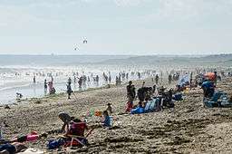
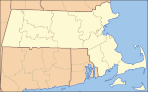
Horseneck Beach State Reservation is a state-owned, public recreation area comprising more than 800 acres (320 ha) on the Atlantic Ocean in the southern portion of the town of Westport, Massachusetts, United States. It is managed by the Massachusetts Department of Conservation and Recreation and is one of the state’s "most popular facilities ... welcom[ing] hundreds of thousands of visitors per year."[3]
Description
The reservation occupies a peninsula that juts out from Westport's mainland with Rhode Island Sound to the southwest and Buzzards Bay to the southeast. The reservation features 2 miles (3.2 km) of barrier beach, marshland, and a protected estuary habitat. Most of the marshland is concentrated at the northern portion of the peninsula bordering Horseneck Channel and The Let.
The barrier island known as Gooseberry Neck (or Gooseberry Island) is connected by a causeway to the main Horseneck Peninsula and is the southernmost extension of Horseneck Beach State Reservation. It partially divides Rhode Island Sound from Buzzards Bay. Horseneck Beach was acquired by the state in 1956, with Goose Neck being added to the state's recreational holdings in 1957.[3]
The Westport Historical Society notes that the name for the beach is likely taken "from the Algonquin word hassanegk, meaning 'cellar dwelling' or 'a house made of stone.'"[4]
Activities and amenities
The state reservation offers fishing, windsurfing, motorized and non-motorized boating with boat ramp, trails for biking and walking, showers, hunting, and bird watching.[5]
- Beach: The beach is located along the southern portion of the peninsula, bordering Rhode Island Sound and Buzzards Bay. Restroom facilities, management office, food bar, designated on-duty lifeguard towers, and paved walkways are found alongside the beach. Swimming is limited to designated beaches.
- Camping: A 100-site campground is located behind the dunes at Gooseberry Neck, at the eastern end of the reservation. Camping season runs mid-May to mid-October. Campground office hours are 8am–10pm. Facilities include a dump station.[5]
Accessibility
The state reservation is accessible from the Bascule Bridge via Route 88, an offshoot of Interstate 195. Route 88 is the main (and direct) route of the two land routes to Horseneck. Route 88 ends on Horseneck, where John Reed Road, the main road serving the reservation, begins. John Reed Road ends at East Beach Road on the eastern portion of the peninsula. The other land route to Horseneck is East Beach Road via Horseneck Road, on the peninsula's connector, near the Westport/Dartmouth town boundary. The beach is accessible from the several large, designated parking lots via toll gates.
References
External links
|
|---|
|
|
|
|
|
|
|
| Wildlife Management Areas |
|---|
| Wildlife
Management Areas | |
|---|
| Wildlife
Sanctuaries |
- Billingsgate Island
- Carr Island
- E. Howe Forbush
- Egg Rock
- Grace A. Robson
- J.C. Phillips
- Knight
- Penikese Island
- Ram Island (Salisbury)
- Ram Island (Mattapoisett)
- Susan B. Minns
- Tarpaulin Cove
- Watatic Mountain
|
|---|
|
|
|
| |
|---|
|
- Black Pond Bog
- Boat Meadow
- Francis Newhall Woods
- Grassy Pond
- Greene Swamp
- Halfway Pond Island
- Hawley Bog
- Hockomock Swamp
- Hoft Farm
- Homer-Watcha Preserve
- Katama Plains
- McElwain-Olsen
- Miacomet Moors
- Reed Brook
- Drury
- Sandy Neck
- David H. Smith Preserve and Fire Trail
- Stacy Mountain
- Tatkon
|
|
|
|
|
|
|
|
|
|