Hingham, Wisconsin
| Hingham, Wisconsin | |
|---|---|
| Census-designated place | |
 Hingham, Wisconsin | |
| Coordinates: 43°38′20″N 87°54′51″W / 43.63889°N 87.91417°WCoordinates: 43°38′20″N 87°54′51″W / 43.63889°N 87.91417°W | |
| Country | United States |
| State | Wisconsin |
| County | Sheboygan |
| Area | |
| • Total | 2.786 sq mi (7.22 km2) |
| • Land | 2.695 sq mi (6.98 km2) |
| • Water | 0.091 sq mi (0.24 km2) |
| Elevation | 804 ft (245 m) |
| Population (2010 census) | |
| • Total | 886 |
| • Density | 320/sq mi (120/km2) |
| Time zone | Central (CST) (UTC-6) |
| • Summer (DST) | CDT (UTC-5) |
| ZIP code | 53031 |
| Area code(s) | 920 |
| GNIS feature ID | 1566481[1] |
Hingham is an unincorporated census-designated place located in the town of Lima, in Sheboygan County, Wisconsin, United States. Hingham is northeast of Adell and southeast of Waldo. Hingham has a post office with ZIP code 53031.[2] As of the 2010 census, its population was 886.[3]
History
According to Gustav W. Buchen in "Historic Sheboygan County", the community of Hingham was platted on Sept. 5, 1850, by Edward Hobart. The land was acquired from Mrs. David Giddings, who had bought it from the U S Government in 1846. A Hingham resident, Lemuel Tibbitts, who was a deputy county surveyor, did the platting. Streets on the original plat included Water, Center, Spring, South and Main Streets. The name "Hingham" was chosen after the town in Massachusetts.[4]
References
- ↑ U.S. Geological Survey Geographic Names Information System: Hingham, Wisconsin
- ↑ ZIP Code Lookup
- ↑ "American FactFinder". U.S. Census Bureau. Retrieved 5 April 2011.
- ↑ 'Historic Sheboygan County," Gustav W. Buchen, 1976, p. 275
Municipalities and communities of Sheboygan County, Wisconsin, United States | ||
|---|---|---|
| Cities | 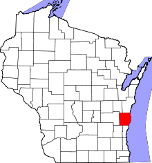 | |
| Villages | ||
| Towns | ||
| CDPs | ||
| Unincorporated communities | ||
| Ghost towns | ||
| Footnotes | ‡This populated place also has portions in an adjacent county or counties | |