Hillsboro, Oregon
| Hillsboro, Oregon | ||
|---|---|---|
| City | ||
|
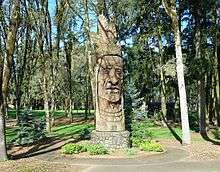
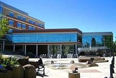
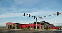
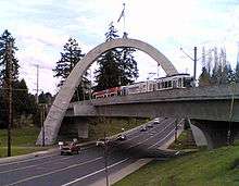
From top: City Hall, Chief Kno-Tah, Main Street Bridge, fountain at The Streets of Tanasbourne, Downtown with Mount Hood and Tuality Hospital in the background, and Intel's Ronler Acres Campus | ||
| ||
| Nickname(s): The Hub City[1] | ||
 Location of Hillsboro in the state of Oregon | ||
 Hillsboro, Oregon Location in the United States | ||
| Coordinates: 45°31′N 122°59′W / 45.517°N 122.983°WCoordinates: 45°31′N 122°59′W / 45.517°N 122.983°W | ||
| Country | United States | |
| State | Oregon | |
| County | Washington County | |
| Incorporated | October 19, 1876 | |
| Named for | David Hill | |
| Government | ||
| • Type | Council–manager | |
| • Mayor | Jerry Willey (R)[2] | |
| • City manager | Michael Brown | |
| Area[3] | ||
| • Total | 24.25 sq mi (62.8 km2) | |
| • Land | 24.24 sq mi (62.8 km2) | |
| • Water | 0.01 sq mi (0.03 km2) | |
| Elevation | 194 ft (60 m) | |
| Population (2010)[4] | ||
| • Total | 91,611 | |
| • Estimate (2015)[5] | 102,347 | |
| • Rank |
1st in Washington County 5th in Oregon 303rd in United States | |
| • Density | 3,833.1/sq mi (1,480.0/km2) | |
| Time zone | PST (UTC-8) | |
| • Summer (DST) | PDT (UTC-7) | |
| ZIP codes | 97123, 97124, 97006 | |
| Area code(s) | 503 and 971 | |
| FIPS code | 41-34100[6] | |
| GNIS feature ID | 1163049[7] | |
| Demonym | Hillsboroans[8] | |
| Website | www.hillsboro-oregon.gov | |

Hillsboro (/ˈhɪlzbəroʊ/) is the fifth-largest city in the State of Oregon and is the county seat of Washington County.[9] Lying in the Tualatin Valley on the west side of the Portland metropolitan area, the city hosts many high-technology companies, such as Intel, that comprise what has become known as the Silicon Forest. At the 2010 Census, the city's population was 91,611.[10]
For thousands of years before the arrival of European-American settlers, the Atfalati tribe of the Kalapuya lived in the Tualatin Valley near the later site of Hillsboro. The climate, moderated by the Pacific Ocean, helped make the region suitable for fishing, hunting, food gathering, and agriculture. Settlers founded a community here in 1842, later named after David Hill, an Oregon politician. Transportation by riverboat on the Tualatin River was part of Hillsboro's settler economy. A railroad reached the area in the early 1870s and an interurban electric railway about four decades later. These railways, as well as highways, aided the slow growth of the city to about 2,000 people by 1910 and about 5,000 by 1950, before the arrival of high-tech companies in the 1980s.
Hillsboro has a council–manager government consisting of a city manager and a city council headed by a mayor. In addition to high-tech industry, sectors important to Hillsboro's economy are health care, retail sales, and agriculture, including grapes and wineries. The city operates more than twenty parks and the mixed-use Hillsboro Stadium, and ten sites in the city are listed on the National Register of Historic Places (NRHP). Modes of transportation include private vehicles, public buses and light rail, and aircraft using the Hillsboro Airport. The city is home to Pacific University's Health Professions Campus. Notable residents include two Oregon governors.
History
The first people of the Tualatin Valley were the Atfalati or Tualaty tribe of the Kalapuya, who inhabited the region for up to 10,000 years before white settlers arrived. The valley consisted of open grassland maintained through annual burning by the Atfalati, with scattered groves of trees along the streams. The Kalapuya moved from place to place in good weather to fish and hunt and to gather nuts, seeds, roots, and berries. Important foods included camas and wapato, and the Atfalati traded for salmon from Chinookan tribes near Willamette Falls on the Willamette River. During the winter, they lived in longhouses in settled villages, some near what became Hillsboro and Beaverton. Their population was greatly reduced after contact in the late 18th century with Europeans, who carried smallpox, syphilis, and malaria. Of the original population of 1,000 to 2,000 Atfalati reported in 1780, only 65 remained in 1851. In 1855, the U.S. government sent the survivors to the Grande Ronde reservation further west.[11]
The European-American community was founded by David Hill, Isaiah Kelsey, and Richard Williams, who arrived in the Tualatin Valley in 1841, followed by six more pioneers in 1842.[12] The locality went by two other names—East Tualatin Plains and Columbia—before it was named "Hillsborough" in February 1850 in honor of Hill, when he sold part of his land claim to the county.[13] On February 5, 1850, commissioners chosen by the territorial legislature selected the community to be the seat of the county government.[13] Hill was to be paid $200 for his land after plots had been sold for the town site,[13] but he died before this occurred, and his widow Lucinda received the funds.[14] The town's name was later simplified to Hillsboro. A log cabin was built in 1853 to serve as the community's first school, which opened in October 1854.[15] Riverboats provided transportation to Hillsboro as early as 1867 when the side-wheel steamer Yamhill worked on the Tualatin River.[12]
In 1871, the Oregon and California Railroad line was extended to the area, but it ran just south of town because the city did not want to give the railroad land in exchange for the rail connection.[12] Hillsboro was incorporated as the Town of Hillsboro on October 19, 1876, by the Oregon Legislature.[16] The first mayor was A. Luelling, who took office on December 8, 1876, and served a one-year term.[17] Notable later mayors included Congressman Thomas H. Tongue (1882 and 1886) and state senator William D. Hare (1885).[17] In 1923, the city altered its charter and adopted a council-manager government with a six-person city council, a part-time mayor who determined major policies, and a city manager who ran day-to-day operations.[18]
On September 30, 1908, 5,000 people gathered as the Oregon Electric Railway opened a connection between the city and Portland with an interurban electric rail line, the first to reach the community.[19] In January 1914, the Southern Pacific Railroad introduced its own interurban service, known as the Red Electric, on a separate line and serving different communities between Hillsboro and Portland.[20][21] SP discontinued its Hillsboro service on July 28, 1929,[21] while the Oregon Electric Railway's passenger service to Hillsboro lasted until July 1932.[20]
A brick building was constructed in 1852 to house the county government, followed by a brick courthouse in 1873.[22] In 1891, the courthouse was remodeled and a clock tower was added,[23] and the building was expanded with an annex in 1912. A new courthouse replaced the brick structure in 1928. The last major remodel of the 1928 structure occurred in 1972, when the Justice Services Building was built and incorporated into the existing building.[22]
The city's first fire department was a hook and ladder company organized in 1880 by the board of trustees (now city council).[24] A drinking water and electricity distribution system added in 1892–93 gave the town three fire hydrants and minimal street lighting.[25] Hillsboro built its first sewer system in 1911, but sewage treatment was not added until 1936.[26] In 1913, the city built its own water system,[27] and the first library, Carnegie City Library, opened in December 1914.[28] From 1921 to 1952, the world's second-tallest radio tower stood on the south side of the city,[29] but in 1952, the wireless telegraph tower was demolished.
In 1972, the Hillsboro City Council passed a Green River Ordinance banning door-to-door solicitation, but it was ruled unconstitutional by the Oregon Supreme Court in a 1988 decision.[30] The court determined that the city ordinance was overly broad, in a case that was seen as a test case for many similar laws in the state.[30] In 1979, Intel opened its first facility in Hillsboro.[31] The Hawthorn Farm campus was followed by the Jones Farm campus adjacent to the airport in 1982, and finally by the Ronler Acres campus in 1994.[31] TriMet opened a Metropolitan Area Express (MAX) light rail line into the city in 1998. A cultural center was added in 2004, and a new city hall was completed in 2005. In 2008, SolarWorld opened a facility producing solar wafers, crystals, and cells, the largest plant of its kind in the Western Hemisphere.[32] U.S. President Barack Obama visited the city and Intel's Ronler Acres campus in February 2011.[33]
Registered Historic Places
Properties listed on the National Register of Historic Places (NRHP) in and around Hillsboro include the Old Scotch Church, completed in 1876 north of the city.[34] Near the Orenco neighborhood is Imbrie Farm, which includes a house built in 1866 and the Frank Imbrie Barn, both of which McMenamins converted for use as a brewpub.[34][35] Built in 1935, the Harold Wass Ray House is near Intel's Hawthorn Farm campus.[34] Historic properties in downtown include the Zula Linklater House (completed 1923), Rice–Gates House (1890), Edward Schulmerich House (c. 1915), and Charles Shorey House (c. 1908).[34] The Richard and Helen Rice House is adjacent to the Sunset Highway on the north side of the city and houses the Rice Northwest Museum of Rocks and Minerals.[34] The Old Washington County Jail had been at the Washington County Fairgrounds in the city,[34] but was restored and moved to the Washington County Museum outside the city in 2004, and was de-listed from the NRHP in 2008.[36][37] In 2007, the Manning–Kamna Farm was added to the NRHP and includes 10 buildings, dating to as early as 1883.[38] The Malcolm McDonald House in Orenco was added to the Registry in 2015.[39]
Geography
Hillsboro is located at 45°31′N 122°59′W / 45.517°N 122.983°W.[7] The United States Census Bureau reports the city has a total area of 21.6 square miles (55.9 km2), all of which is land. In 2013, Hillsboro itself reported an area of 23.88 square miles (61.8 km2), equivalent to 15,283 acres (61.8 km2).[40] The city is located in the Tualatin Valley, and the Tualatin River forms part of the southern city limits. The city's terrain is fairly level, consistent with an agricultural past and the farms still in operation.[41][42] Hillsboro is about 17 miles (27 km) west of Portland and immediately west of Beaverton, at an elevation of 194 feet (59 m) above sea level.[7] In addition to the Tualatin River, streams include Dairy Creek, McKay Creek, Rock Creek, Dawson Creek, and Turner Creek. Neighboring communities in addition to Beaverton are Aloha, Cornelius, North Plains, Reedville, Scholls, and West Union.
Hillsboro's street system differs from many others in the county.[43] Most cities in Washington County use a numbering system and cardinal direction orientation based on a grid that begins at the Willamette River in downtown Portland, which was originally part of Washington County.[43] For example, the street names in Beaverton generally include Southwest (SW) prefixes because Beaverton lies in the southwest quadrant of the Portland grid. In Hillsboro, some county road names and addresses conform to the Portland grid instead of Hillsboro's internal cardinal direction grid,[44] and the city has been working to make addresses and streets within Hillsboro conform to the internal grid.[44][45]
The internal grid in Hillsboro centers on the downtown intersection of Main Street, which runs east–west, and First Avenue, which runs north–south. Most addresses within the city include a quadrant prefix: NW, NE, SW, or SE. Main Street is simply designated as East Main or West Main, and First Avenue is only North First or South First.[46] Addresses on the streets' south side and the avenues' east side have even numbers, while odd numbers are on the opposite side.[46] Hillsboro's street system contains 20 blocks per mile (12.5 blocks per kilometer).[46]
North–south through roadways are called avenues, while east–west roadways are called streets.[47] All cul-de-sacs are named as either places or courts.[47] Roads that curve can be named drives.[47] Non-city streets may not conform to these naming conventions.[44]
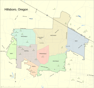
The city is divided into eight planning areas, each of which contains several neighborhoods.[48] The east planning area contains the Tanasbourne neighborhood and Oregon Health & Science University's West Campus.[48] The northeast planning area includes the Orenco, Orenco Station, Airport, and West Union neighborhoods.[48] Jackson School, Sunrise, and Glencoe neighborhoods lie in the northwest area,[48] and the Dennis, Garibaldi, and Connell neighborhoods are in the west area.[48] The central area includes the Downtown, Jackson Bottom, Henry, and Eastwood neighborhoods.[48] Blocks in the downtown core are 400 feet (120 m) long on each side.[49] The Minter Bridge, Rood Bridge, and River Road neighborhoods are in the south planning area;[48] the southeast area consists of the Reedville and Witch Hazel neighborhoods,[48] and the Brookwood planning area in the center of the city contains the Cedar, Bentley, and Brogden neighborhoods.[48]
Landmarks in Hillsboro include the Washington County Courthouse, the seat of county government.[50] Along the western edge of the city is Hillsboro Pioneer Cemetery, established in 1870, which serves as the final resting place of city pioneers and politicians.[51] Next to the airport is the Washington County Fair Complex, home to the annual county fair.[52] Located at Shute Park is the 25-foot (7.6 m) tall wood sculpture Chief Kno-Tah, donated to Hillsboro and dedicated in 1987 as part of Peter Wolf Toth's Trail of the Whispering Giants.[53][54][55][56]
Climate
Summers in Hillsboro are generally warm, but temperatures year-round are moderated by a marine influence from the Pacific Ocean.[57] The Willamette Valley in which Hillsboro lies receives the majority of its precipitation during the winter months, with the wettest period from November through March.[57] This occasionally includes snowfall.[58] Hillsboro receives precipitation on 161 days per year, on average.[59] The average yearly precipitation between 1930 and 1998 was 38 inches (970 mm).[60] August is the warmest month with an average high temperature of 81 °F (27 °C), while January is the coolest month with an average high of 46 °F (8 °C).[61] The highest recorded temperature, 108 °F (42 °C), occurred on July 19, 1956, and the lowest, −10 °F (−23 °C), occurred on January 31, 1950.[61]
According to the Köppen climate classification system, Hillsboro has a warm-summer Mediterranean climate (Köppen Csb).
| Climate data for Hillsboro | |||||||||||||
|---|---|---|---|---|---|---|---|---|---|---|---|---|---|
| Month | Jan | Feb | Mar | Apr | May | Jun | Jul | Aug | Sep | Oct | Nov | Dec | Year |
| Record high °F (°C) | 69 (21) |
70 (21) |
83 (28) |
90 (32) |
100 (38) |
102 (39) |
108 (42) |
106 (41) |
103 (39) |
92 (33) |
78 (26) |
64 (18) |
108 (42) |
| Average high °F (°C) | 45 (7) |
50.6 (10.3) |
55.6 (13.1) |
62.1 (16.7) |
68.7 (20.4) |
74 (23) |
81 (27) |
80.9 (27.2) |
75.9 (24.4) |
64.3 (17.9) |
52.4 (11.3) |
46.4 (8) |
63.1 (17.3) |
| Average low °F (°C) | 32.7 (0.4) |
34.6 (1.4) |
36.8 (2.7) |
39.8 (4.3) |
44.1 (6.7) |
48.9 (9.4) |
51.9 (11.1) |
51.2 (10.7) |
47.4 (8.6) |
41.6 (5.3) |
37.1 (2.8) |
34.2 (1.2) |
41.7 (5.4) |
| Record low °F (°C) | −14 (−26) |
−9 (−23) |
18 (−8) |
20 (−7) |
26 (−3) |
30 (−1) |
36 (2) |
30 (−1) |
29 (−2) |
21 (−6) |
8 (−13) |
−2 (−19) |
−14 (−26) |
| Average precipitation inches (mm) | 5.99 (152.1) |
4.42 (112.3) |
3.93 (99.8) |
2.2 (56) |
1.75 (44.4) |
1.42 (36.1) |
0.46 (11.7) |
0.73 (18.5) |
1.43 (36.3) |
2.98 (75.7) |
5.63 (143) |
6.8 (173) |
37.74 (958.6) |
| Average precipitation days | 20 | 16 | 17 | 14 | 11 | 8 | 3 | 4 | 7 | 12 | 19 | 20 | 151 |
| Source: [62] | |||||||||||||
Demographics
| Historical population | |||
|---|---|---|---|
| Census | Pop. | %± | |
| 1880 | 402 | — | |
| 1890 | 1,246 | 210.0% | |
| 1900 | 980 | −21.3% | |
| 1910 | 2,016 | 105.7% | |
| 1920 | 2,468 | 22.4% | |
| 1930 | 3,039 | 23.1% | |
| 1940 | 3,747 | 23.3% | |
| 1950 | 5,142 | 37.2% | |
| 1960 | 8,232 | 60.1% | |
| 1970 | 15,365 | 86.6% | |
| 1980 | 27,664 | 80.0% | |
| 1990 | 37,598 | 35.9% | |
| 2000 | 70,187 | 86.7% | |
| 2010 | 91,611 | 30.5% | |
| Est. 2015 | 102,347 | [5] | 11.7% |
| U.S. Decennial Census[63] 2013 Estimate[64] | |||
Hillsboro's population grew from 402 in 1880 to 2,016 by 1910, making it the county's most populated city, according to the 1910 census data.[65] By 1970, it had increased to more than 15,000, although neighboring Beaverton had overtaken it as the county's most populous city.[66] By 1990 there were more than 37,000 residents, and commuters raised this to 110,000 during daytime.[67][68] At the 2010 Census, the population was 91,611,[10] fifth in rank among the state's largest cities behind Portland, Eugene, Salem and Gresham and slightly ahead of Beaverton, which ranked sixth.[69] This figure was a 30.5 percent increase from Hillsboro's 70,186 residents in 2000, which made Hillsboro the fourth fastest-growing city in the state during the 2000s (decade), and the fastest-growing city in the Willamette Valley over the same period. In 2007, there were 17,126 houses lived in by their owners, with an average home price in the city of $246,900.[70] Bloomberg Businessweek listed the city as the fastest-growing in Oregon for the period between 1990 and 2010, for cities with populations over 10,000.[71][72]
2010 census
As of the census of 2010, there were 91,611 people, 33,289 households, and 22,440 families residing in the city. The population density was about 3,800 inhabitants per square mile (1,500/km2). There were 35,487 housing units at an average density of about 1,500 per square mile (600/km2). The racial makeup of the city was approximately 73% White, 2% African American, 1% Native American, 9% Asian, less than 1% Pacific Islander, 10% from other races, and 5% from two or more races. Hispanic or Latino of any race were about 23% of the population.[4]
There were 33,289 households of which about 38% had children under the age of 18 living with them, 51% were married couples living together, 11% had a female householder with no husband present, 5% had a male householder with no wife present, and 33% were non-families. About 24% of all households were made up of individuals and 6% had someone living alone who was 65 years of age or older. The average household size was 2.71 and the average family size was 3.24.[4]
The median age in the city was 32 years. About 27% of residents were under the age of 18; 9% were between the ages of 18 and 24; 35% were from 25 to 44; 21% were from 45 to 64; and 8% were 65 years of age or older. The gender makeup of the city was 50.2% male and 49.8% female.[4]
2000 census
At the time of the 2000 census, there were 25,079 households, of which about 38% had children under the age of 18 living with them, 55% were married couples living together, 9% had a female householder with no husband present, and 32% were non-families. About 23% of all households were made up of individuals and 5% had someone living alone who was 65 years of age or older. The average household size was 2.8 and the average family size was 3.3.[4]
City residents included about 28% under the age of 18, 11% from 18 to 24, 37% from 25 to 44, 17% from 45 to 64, and 6% who were 65 years of age or older. The median age was 30 years. For every 100 females there were about 106 males.[4]
The median household income was about $52,000 and the median family income was $57,000. Males had a median income of $41,000 compared to $30,000 for females.[4] The per capita income for the city was about $22,000.[4] Approximately 6% of families and 9% of the population were below the poverty line, including 11% of those under age 18 and 8% of those age 65 or over.[4] In 2007, 28% of people 25 and older held at least a bachelor's degree, while an additional 11% held an associate degree.[70] Those with less than a high school diploma made up 15% of the population, and 22% of residents had more than a high school diploma but less than a college degree.[70]
Crime
| Hillsboro | |
| Crime rates (2012) | |
| Crime type | Rate* |
|---|---|
| Homicide: | 2 |
| Robbery: | 52 |
| Aggravated assault: | 92 |
| Total violent crime: | 180 |
| Burglary: | 323 |
| Larceny-theft: | 1,716 |
| Motor vehicle theft: | 115 |
| Arson: | 6 |
| Total property crime: | 2,154 |
| Notes * Number of reported crimes per 100,000 population. 2012 population: 94,119 |
|
| Source: 2012 FBI UCR Data | |
For the year 2011, the city had 180 violent crimes reported to law enforcement, and 2,154 reports of property crimes.[73] The violent crime rate was 157.2 per 100,000 people compared to a national average of 309.3[74] and 287 for Oregon.[75] Property crime nationally was 3,335[74] per 100,000 compared to 3,203 in Hillsboro, and 4,402 for the state.[75] Violent offenses include forcible rape, robbery, murder, non-negligent manslaughter, and aggravated assault. Property crimes include arson, motor vehicle theft, larceny, and burglary.[73] Statistics published by the Oregon Criminal Justice Commission showed a slight downward trend in the Washington County crime rate between 1991 and 2005. The rate for index crimes, a group comprising the combined violent offenses and property crimes mentioned above, was 3,930 per 100,000 in 1991 and rose to 4,440 per 100,000 in 1997 before falling to 3,410 per 100,000 in 2005.[76]
Economy
| Employer | Employees (November 2015)[77] |
|---|---|
| 1. Intel | 17,500 |
| 2. Hillsboro School District | 2,205 |
| 3. Nike | 1,811 |
| 4. Washington County | 1,715 |
| 5. Wells Fargo | 1,681 |
| 6. Tuality HealthCare | 1,400 |
| 7. Qorvo | 1,085 |
| 8. SolarWorld | 750 |
| 9. City of Hillsboro | 705 |
| 10. FEI Company | 450 |
Manufacturing is the leading employment sector in Hillsboro, employing 24% of the workforce, followed by health care, education, and social services with a total of 15%.[70] One example of a manufacturer headquartered in Hillsboro is Beaverton Foods, a family-owned condiment manufacturer since 1929, with 70+ employees and $25 million in annual sales; it moved to its current headquarters in 2001.[78] Retail employment constitutes 12%, construction makes up 7%, and 13% of workers are employed in the administrative, scientific, professional, or waste management industries.[70] Sixty-eight percent of workers commute alone to the workplace, and eight percent use public transportation.[70] The average one-way commute time is about 24 minutes.[70]
Many technology companies operate in Hillsboro, making it the center of Oregon's Silicon Forest.[79][80] In particular, Intel's[81] largest site is in Hillsboro, and includes three large campuses: Ronler Acres, Jones Farm, and Hawthorn Farm, along with several smaller campuses that employ about 16,000 workers.[82] Other high-tech companies operating facilities in Hillsboro include Yahoo!,[83] Credence Systems, Synopsys, Epson,[84] Salesforce,[85] and Oracle's (formerly Sun Microsystems) High-End Operations. Hillsboro is the co-corporate headquarters for Qorvo (formerly TriQuint Semiconductor),[82] RadiSys, and Planar Systems among others.[86]
In 2006, Genentech announced plans to locate a packaging and distribution facility on 100 acres (0.40 km2) in Hillsboro.[87] The $400 million facility opened in 2010, which Oregon officials hoped would eventually also be used for research and development for the biotechnology company.[88] Other biotech or medical companies based in Hillsboro include FEI Company and Acumed.[89]
The city is also a landing point on three fiber optic cable systems linking the United States across the Pacific Ocean: C2C, Southern Cross Cable, and VSNL Transpacific. These cable landings, lower energy costs, and tax breaks led to a boom of data centers being built starting about 2010.[90] Data centers include those for Adobe, NetApp, Umpqua Bank, OHSU, and Fortune Data Centers.[90]

Hillsboro serves as the corporate headquarters for Rodgers Instruments, Soloflex, Norm Thompson Outfitters, SureID, and Parr Lumber, among others. Fujitsu and NEC Corporation formerly had factories in Hillsboro.[91] Hillsboro is also home to the Laika stop-motion animation studio, creator of the Oscar-nominated feature films Coraline (2009) and Paranorman (2012).[92]
The Hatfield Government Center in Hillsboro is the western terminus of the MAX Blue Line, part of the Portland metropolitan area's light-rail system.[93] The presence of MAX prompted the development of the pedestrian-oriented community of Orenco Station within Hillsboro.[94][95] (See also: Orenco, Oregon.) Orenco Station was called the Best Planned Community of 1999 by the National Association of Home Builders.[96] It was also named "Best new burb" by Sunset magazine in 2006.[97] Hillsboro overall was listed on CNN Money Magazine's list of best places to live in 2010 for cities with populations between 50,000 and 300,000 residents.[98] The city came in at 92, the highest ranking for any city in the state.[98]

Hillsboro's primary commercial cores are concentrated along Tualatin Valley Highway and Cornell Road. Additionally, the Tanasbourne neighborhood is a regional shopping area on the eastern edge of the city.[99] The neighborhood is home to the lifestyle shopping center The Streets of Tanasbourne.[100] The $55 million outdoor complex with 368,000 square feet (34,200 m2) of retail space opened in 2004 with Meier & Frank (later Macy's) as the anchor tenant.[99][100]
The other large shopping center in the city is The Sunset Esplanade, located along Tualatin Valley Highway.[101] In November 2005, the world's largest Costco, a warehouse club store, opened in Hillsboro.[102] The store, with 205,000 square feet (19,000 m2) of floor space, is about 60,000 square feet (5,600 m2) bigger than the average Costco.[103]
Wineries near the city include Oak Knoll Winery, established in 1970, the oldest and largest winery in Washington County.[104][105] Helvetia Winery & Vineyards to the north of Hillsboro started in the 1980s.[59] Wineries to the south include Gypsy Dancer Estates Winery and Raptor Ridge.[106] Local wines include pinot noir, pinot gris, and chardonnay.[107]
Culture

Within the city are three commercial movie theaters with a total of 30 screens. This includes the Venetian Theatre that re-opened at the site of the old Town Theater in 2008.[108] The Oregon Chorale (a 60-person symphonic choir),[109] a men's barbershop chorus,[110] the Hillsboro Symphony Orchestra, and the Hillsboro Artists' Regional Theatre are also located in Hillsboro.[111] The orchestra was founded in 2001 under the direction of Stefan Minde.[112] In 2004, the city opened the Glenn & Viola Walters Cultural Arts Center in a remodeled church in downtown.[86] The center provides space for galleries and performances, as well as classrooms for art instruction.[86] The Rice Northwest Museum of Rocks and Minerals is located on the northern edge of the city.[113] The Washington County Museum returned to downtown Hillsboro in 2012 when it moved into the Civic Center.[114]
Hillsboro operates two library branches. Opened in 2007 after a smaller location was closed, the 38,000-square-foot (3,500 m2) main branch is located in the north-central section of the city.[115] The older, smaller second branch is in Shute Park in the southwest area of the city. The Hillsboro libraries are part of Washington County Cooperative Library Services, which allows residents to use other libraries in the county and includes interlibrary loans.[116]
Media
AM radio station KUIK, the weekly Hillsboro Argus newspaper (twice-weekly until 2015), and the Hillsboro Tribune are based in Hillsboro. The Argus is published on Wednesdays,[117] and has been in circulation since 1873.[118] KUIK is a 5,000-watt station broadcasting at the 1360 frequency. The Tribune started in September 2012 and now publishes weekly.[119] The city is also served by Portland-area media outlets including The Oregonian, Willamette Week, and all broadcast stations.[67]
Recreation
Hillsboro's Department of Parks and Recreation operates more than 20 facilities, including Hillsboro Stadium. There are 23 parks, two sports complexes, the Walters Cultural Arts Center, the Shute Park Aquatic & Recreation Center, and three other mixed-use facilities.[120] The city also owns the Jackson Bottom Wetlands Preserve along the Tualatin River on the south side of the community.[121][122] South of city is Bald Peak State Scenic Viewpoint, which is day-use only, and is the closest state park to Hillsboro. L.L. "Stub" Stewart Memorial State Park is the closest full-service state park.
Local golf courses include The Reserve Vineyards and Golf Club (36 holes) that was completed in 1997, Meriwether National Golf Course (27 holes) established in 1961, and the 9-hole McKay Creek Golf Course that was built in 1995.[122] Other courses in the area include Killarney West Golf Club (9 holes), Rock Creek Country Club (18 holes), Forest Hills Country Club (18 holes), and Pumpkin Ridge Golf Club (36 holes).
Hillsboro's annual Fourth of July Parade is the second-largest Independence Day parade in Oregon.[123][124] The Oregon International Air Show, Oregon's largest air show, is held each year during the summer at the Hillsboro Airport.[70] Each summer the city offers a free concert series at Shute Park (Showtime at Shute),[125] while the Washington County Fair is held annually at the county fairgrounds adjacent to the airport.[126]
Hillsboro Farmers' Markets operates weekend farmers' markets on Saturdays downtown and on Sundays at Orenco Station, from May to October.[70] The Saturday market began in 1982 and sells arts and crafts, food, produce, and plants.[127] A different organization, Hillsboro Tuesday Marketplace, operates a downtown farmers' market on Tuesdays from mid-June through September 1.[128] Farmers' markets also operate on Wednesday afternoons from June through August at Kaiser Permanente[129] and on Thursday afternoons at Tuality Hospital from June through August.[130]
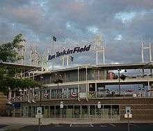
The city has one professional sports team, the Hillsboro Hops of the Northwest League, a Minor League Baseball club affiliated with the Arizona Diamondbacks. The baseball team relocated from Yakima, Washington in 2012 and began play as the Hops on June 14, 2013, with its inaugural home game at the new Ron Tonkin Field on June 17.[131]
Government
Hillsboro operates under a council–manager form of city government. Voters elect six at-large councilors and a mayor, who each serve four-year terms, subject to a charter-imposed limitation of two consecutive terms.[132] The mayor and council appoint a city manager to conduct the ordinary business of the city. Policy decisions are the responsibility of the council and mayor. Administrative functions are carried out by the manager and manager-appointed staff.[133] Government functions are centered at the Hillsboro Civic Center, which houses the office of the city manager and is the location of the twice-monthly city council meetings.[132] As of November 2015, Jerry Willey was mayor with Darell Lumaco, Rick Van Beveren, Kyle Allen, Olga Acuña, Steve Callaway, and Fred Nachtigal as the city councilors.[134] Michael Brown serves as the city's manager.[135]
Hillsboro operates its own library system, fire department, parks department, water system, and police department.[67] The Hillsboro Fire Department has five stations, and the Hillsboro Police Department operates two standard precincts and a mobile precinct.[67][136][137] Wastewater treatment is provided through the county-wide Clean Water Services.
At the federal level, Hillsboro lies in Oregon's 1st congressional district, represented by Suzanne Bonamici.[138] In the State Senate, Hillsboro is in District 15, represented by Bruce Starr, District 13, represented by Larry George, and District 12 represented by Brian Boquist. In the House, Districts 24 (Jim Weidner), 26 (John Davis), 29 (Ben Unger) and 30 (Joe Gallegos) cover the city.[139] Parts of county commissioner districts 1 (Dick Schouten), 2 (Desari Strader), and 4 (Andy Duyck) overlap the city.[140] In addition, Hillsboro lies within District 4 (Kathryn Harrington) of the Metro regional government.[141]
Education

Public schools in Hillsboro are operated by the Hillsboro School District (1J). The district is a unified school district with twenty-three elementary schools, four middle schools, and four high schools.[70] The district also operates the Miller Education Center, an alternative school, the Hare Field athletic complex, and City View Charter School.[142] The school district covers Hillsboro, Scholls, Reedville, North Plains, West Union, and other surrounding communities.[70] Total enrollment as of 2012 was 20,903 students, making it the fourth largest district in the state.[143] The four traditional public high schools are, in order of creation:
| Name | Current campus | Enrollment (2014–15)[144] | Nickname |
|---|---|---|---|
| Hillsboro High School | 1969 | 1,322 | Spartans |
| Glencoe High School | 1980 | 1,579 | Crimson Tide |
| Century High School | 1997 | 1,595 | Jaguars |
| Liberty High School | 2003 | 1,469 | Falcons |
Post-secondary educational opportunities include the west campus of Oregon Health & Science University (OHSU)[145] while Pacific University operates a satellite Health Professions Campus in downtown adjacent to Tuality Community Hospital.[70] The OHSU site was formerly that of the Oregon Graduate Institute (now OGI School of Science and Engineering) and the Oregon National Primate Research Center portions of OHSU. Other educational opportunities are available at the Work Force Training Center (Portland Community College) and a branch of the University of Phoenix. Hillsboro is home to private primary and secondary schools including Faith Bible High School, St. Matthew Catholic School, Tualatin Valley Academy, and Renaissance Alternative School, among others.[146]
Infrastructure
Transportation
Public transportation is available by bus and light rail, managed by regional transit agency TriMet.[70] The first MAX light rail line, now known as the Blue Line, was extended to serve Hillsboro on September 12, 1998.[147] The western terminus is located downtown. The Willow Creek and Hillsboro transit centers (TC) are the main hubs of the public transit system, although seven other MAX stations provide varying degrees of bus interconnection. MAX Stations (west to east) are the Hatfield Government Center, Hillsboro Central TC, Tuality Hospital, Washington/Southeast 12th Avenue, Fair Complex / Hillsboro Airport, Hawthorn Farm, Orenco, Quatama, and Willow Creek TC. Located next to the Tuality Hospital station is the Hillsboro Intermodal Transit Facility, which opened in 2010 and was jointly paid for by the hospital, Pacific University, and the city.[148] The facility is primarily a parking garage, but includes lockers and showers for bicyclists along with electric vehicle charging stations.[149]
Freight rail service from Portland and Western Railroad with interconnections to the BNSF Railway and the Union Pacific Railroad both serve Hillsboro.[150] The city is not served by passenger rail service over a heavy-rail line.[67] Air travel is available at the Hillsboro Airport in the center of the city and at Stark's Twin Oaks Airpark, a general aviation field south of the city. The Hillsboro Airport is a general aviation airport operated by the Port of Portland, and is the second-busiest airport in the state after Portland International Airport.[151] The airport mainly serves private pilots and corporate flights, with no scheduled airline flights from its two runways, but does have an on-call customs service.[67][152]
Oregon Route 8, known locally as the Tualatin Valley Highway (TV Highway), is the primary east–west highway.[82] U.S. Route 26, also known as the Sunset Highway, bisects the northeast corner of the city. Other major east–west roads are Cornell Road and Main Street / Baseline Road.[67] Major north–south routes are Oregon Route 219 / 1st Street, 10th Street / Cornell Road, Cornelius Pass Road, and Brookwood.[67] The easternmost north–south route, 185th Avenue, borders Beaverton and runs between the Tanasbourne Town Center and the rest of Hillsboro. TV Highway connects to Cornelius and Forest Grove to the west and Beaverton to the east.
Health care
Hospital services in the city are provided by Tuality Community Hospital in the downtown area of the city.[70] Opened in 1918 as the city's first hospital,[153] the 167-bed facility is operated by Tuality Healthcare. Other significant medical facilities include Kaiser Permanente's Sunset Medical Office and Providence Health & Services' immediate care center, both in the Tanasbourne neighborhood. Kaiser Permanente also opened the Kaiser Westside Medical Center, a 126-bed hospital in 2013, next to its Sunset Medical Office.[154] The Department of Veterans Affairs opened a medical clinic in the Tanasbourne area in 2008.[155]
Notable people

For more than 150 years, the city has had residents as varied as David Hill, the city's founder, to Tiffeny Milbrett, an Olympic and World Cup champion soccer player.[156] Two governors of Oregon, James Withycombe and Paul L. Patterson, have called the city home.[157] Other politicians included Congressmen Thomas H. Tongue and Samuel Thurston; mayors William N. Barrett, Benjamin P. Cornelius, and William D. Hare, patriarch of the Hare political family.[51] Athletes include Erik Ainge, Scott Brosius, Colt Lyerla, Ad Rutschman, Wes Schulmerich, Wally Backman, and Olympic medalists Josh Inman, Thomas Garrigus, and Jean Saubert. Hillsboro has also been home to Peggy Y. Fowler, the former chief executive officer of Portland General Electric, producer Bryce Zabel, the "Mother Queen of Oregon" Mary Ramsey Wood, Tommy Overstreet, and professional wrestler Roddy Piper.[158]
Sister city
Hillsboro's only sister city relationship is with Fukuroi,[159] a city of about 85,000 residents in the Shizuoka Prefecture in central Japan. The cities, which have similar economic bases in agriculture and high technology, began their relationship in November 1988.[160] The relationship has included exchanges of students between schools in each city.[161] In the late 2000s, Hillsboro unsuccessfully explored finding a sister city in Mexico[162] and also neglected the relationship with Fukuroi.[163] However, in 2008, a Fukuroi contingent of adults visited Hillsboro to celebrate the 20th anniversary of the Sister City agreement.[164]
References
- ↑ Dundas, Zach (July 22, 2011). "Go West!". Portland Monthly. Retrieved May 14, 2014.
- ↑ "Oregon Republican Party needs pragmatic, inclusive chair". The Oregonian. 25 December 2012. Retrieved 2 October 2015.
Hillsboro Mayor Jerry Willey, who holds a nonpartisan position but is registered as a Republican.
- ↑ "US Gazetteer files 2013". United States Census Bureau. Retrieved January 26, 2014.
- 1 2 3 4 5 6 7 8 9 "American FactFinder". United States Census Bureau. Archived from the original on December 10, 2014. Retrieved December 21, 2012.
- 1 2 "Annual Estimates of the Resident Population for Incorporated Places: April 1, 2010 to July 1, 2015". Retrieved July 2, 2016.
- ↑ "U.S. Census Bureau Delivers Oregon's 2010 Census Population Totals, Including First Look at Race and Hispanic Origin Data for Legislative Redistricting". U.S. Census Bureau. Retrieved December 31, 2012.
- 1 2 3 "Hillsboro". Geographic Names Information System. United States Geological Survey.
- ↑ "Hillsboroans receive Chavez scholarships". The Hillsboro Argus. May 26, 2009.
- ↑ "Oregon". About Counties. National Association of Counties. 2005. Archived from the original on June 7, 2008.
- 1 2 "Race, Hispanic or Latino, Age, and Housing Occupancy: 2010 more information 2010 Census Redistricting Data (Public Law 94-171) Summary File". American FactFinder. U.S. Census Bureau.
- ↑ Tualatin Riverkeepers (2002). Exploring the Tualatin River Basin. Corvallis, Oregon: Oregon State University Press. pp. 21–23. ISBN 0-87071-540-2.
- 1 2 3 Buan, Carolyn M. (1999). This Far-Off Sunset Land: A Pictorial History of Washington County, Oregon. Virginia Beach, Virginia: Donning Company Publishers. ISBN 1-57864-037-7.
- 1 2 3 "Washington County Probate Court Records". Provisional & Territorial Records. Washington County Probate Court. Film 24 (Reel 15): 10. February 5, 1850.
- ↑ "Washington County Probate Court Records". Provisional & Territorial Records. Washington County Probate Court. Film 24 (Reel 15): 39. August 1850.
- ↑ Philpott, Betty (October 19, 1976). "Hillsboro school began in one-room log cabin in 1854". The Hillsboro Argus.
- ↑ Baker, Frank C. (1891). "Special Laws". The Laws of Oregon, and the Resolutions and Memorials of the Sixteenth Regular Session of the Legislative Assembly Thereof. Salem, Oregon: State Printer: 770.
- 1 2 "The Hub: Mayors City of Hillsboro". The Hillsboro Argus. October 19, 1976. p. 6.
- ↑ "The Hub: Council-manager form works well". The Hillsboro Argus. October 19, 1976. p. 2.
- ↑ "Links Together County Seats". The Oregonian. October 1, 1908. p. 6.
- 1 2 Thompson, Richard (2008). Willamette Valley Railways. Mount Pleasant, SC (US): Arcadia Publishing. pp. 29, 31, 58–59. ISBN 978-0-7385-5601-7.
- 1 2 Dill, Tom; Grande, Walter R. (1994). The Red Electrics: Southern Pacific's Oregon Interurban. Edmonds, WA: Pacific Fast Mail. pp. 23, 96. ISBN 0-915713-28-4.
- 1 2 "Washington County History". Oregon County Historical Records Guide. Oregon State Archives. Retrieved February 2, 2008.
- ↑ "A Brief History". The Washington County Courthouse. Oregon Judicial Department. Archived from the original on August 10, 2007.
- ↑ "The Hub: Hook-ladder Company authorized by trustees". The Hillsboro Argus. October 19, 1976. p. 12.
- ↑ Buan, Carolyn M. This Far-Off Sunset Land: A Pictorial History of Washington County, Oregon. pp. 133–142.
- ↑ "The Hub: Council establishes first sewer district". The Hillsboro Argus. October 19, 1976. p. 2.
- ↑ "The Hub: Officials display foresight in water system". The Hillsboro Argus. October 19, 1976. p. 4.
- ↑ Engen, Edna (October 19, 1976). "The Hub: Culture, knowledge brought to community by new library". The Hillsboro Argus. p. 15.
- ↑ "Communications: World's second-largest tower relayed wireless messages". The Hillsboro Argus. October 19, 1976. p. 8.
- 1 2 Leeson, Fred (September 21, 1988). "High court strikes down anti-peddler ordinance". The Oregonian. p. A1.
- 1 2 Bittner, Werner (July 16, 2000). "Intel's evolution in Oregon". The Oregonian. p. A14.
- ↑ Read, Richard (October 11, 2008). "Oregon prepares to switch on SolarWorld factory in Hillsboro". The Oregonian. Retrieved December 14, 2008.
- ↑ Mapes, Jeff (February 18, 2011). "President Barack Obama embraces Intel's high-tech culture in Oregon". The Oregonian. Retrieved July 3, 2014.
- 1 2 3 4 5 6 "Oregon National Register List" (PDF). Oregon Department of Parks and Recreation. January 5, 2009. p. 47. Retrieved August 13, 2009.
- ↑ "Cornelius Pass Roadhouse" (PDF). McMenamins'. Archived from the original (PDF) on October 25, 2007.
- ↑ Mandel, Michelle (May 13, 2004). "West Zoner: A lockup to lure 'em in". The Oregonian. p. 1.
- ↑ "January 2, 2009". National Register of Historic Places Listings. National Park Service. Retrieved 2009-01-07.
- ↑ Trappen, Michelle (October 26, 2007). "Farm near Hillsboro named historic". The Oregonian.
- ↑ "Weekly Listings: January 23, 2015". National Register of Historic Places. U.S. National Park Service. Retrieved 26 January 2015.
- ↑ "Hillsboro Budget in Brief 2013-14". Documents. City of Hillsboro. October 17, 2013. Retrieved January 11, 2014.
- ↑ "Relations of Tualatin River Water Temperatures to Natural and Human–Caused Factor" (PDF). United States Geological Survey. 1997. Retrieved November 20, 2007.
- ↑ Mandel, Michelle (July 20, 2000). "West Zoner: Pioneers paved way for growth". The Oregonian. p. 1.
- 1 2 Tsao, Emily (November 21, 2002). "Southwest Zoner: Scrambled directions no joke in an emergency". The Oregonian. p. 1.
- 1 2 3 Bermudez, Esmeralda (April 29, 2004). "West Zoner: Reedville readies for readdressing". The Oregonian. p. 1.
- ↑ Anderson, David R. (April 20, 2000). "West Zoner: 113 ways to bring Hillsboro to 2020". The Oregonian. p. 1.
- 1 2 3 "12.24.040 Numbering system". Hillsboro Municipal Code. City of Hillsboro. Retrieved December 16, 2008.
- 1 2 3 "12.22.010 Designation of street names and numbers". Hillsboro Municipal Code. City of Hillsboro. Retrieved December 16, 2008.
- 1 2 3 4 5 6 7 8 9 "Hillsboro Planning Subareas" (PDF). City of Hillsboro. Archived from the original (PDF) on October 26, 2007.
- ↑ Colby, Richard N. (February 23, 1995). "West Zoner: Making tracks into the future". The Oregonian. p. 1.
- ↑ Smith, Jill (November 4, 2004). "West Zoner Beaverton: Art straddles boundary between past, present". The Oregonian. p. 2.
- 1 2 "Life Styles: Historic names mark old gravestones". The Hillsboro Argus. October 19, 1976. p. 5.
- ↑ "The Washington County Fair Complex". Washington County Fair Complex. Retrieved October 8, 2007.
- ↑ Keepfer, Scott (June 25, 2002). "Finding the Toths". The Greenville News. p. 3D.
- ↑ Geeslin, Ned; Cable Neuhaus (September 5, 1988). "Peter Toth has heads–up works in every state, so Canada is next". People. Time Inc.: 133.
- ↑ "Chief Kno-Tah". Parks & Recreation. City of Hillsboro. Retrieved January 10, 2014.
- ↑ Chidester, Bill (September 29, 1987). "'No-Tah' statue dedicated". The Hillsboro Argus.
- 1 2 Taylor, George. "The Climate of Oregon". Oregon Climate Service. Archived from the original on October 15, 2007.
- ↑ Taylor, George H; Hannan, Chris (1999). The Climate of Oregon: From Rain Forest to Desert. Corvallis: Oregon State University Press. p. 51. ISBN 0-87071-468-6.
- 1 2 Go, Alison (October 1, 2007). "Best Places to Retire: Hillsboro, Oregon". U.S. News & World Report. Retrieved on November 24, 2008.
- ↑ "Hillsboro station daily precipitation". Oregon Climate Service. Archived from the original on October 15, 2007.
- 1 2 "Monthly Averages for Hillsboro, Oregon". The Weather Channel Interactive, Inc. Retrieved March 5, 2009.
- ↑ "HILLSBORO, OR (353908)". Western Regional Climate Center. Retrieved November 23, 2015.
- ↑ United States Census Bureau. "Census of Population and Housing". Archived from the original on May 11, 2015. Retrieved September 25, 2013.
- ↑ "Annual Estimates of the Resident Population: April 1, 2010 to July 1, 2013". Retrieved June 15, 2014.
- ↑ Moffat, Riley Moore (1996). Population History of Western U.S. Cities and Towns, 1850-1990. Scarecrow Press. p. 211.
- ↑ "The Hub: County population neared 6,000 century ago". The Hillsboro Argus. October 19, 1976. p. 15.
- 1 2 3 4 5 6 7 8 "Hillsboro Community Profile". Oregon Economic & Community Development Department. Oregon Secretary of State. Archived from the original on April 15, 2008.
- ↑ "Two Mayors, Two Visions: How Conversations Can Change Communities". Friday Forums Archive for July 14, 2006. City Club of Portland.
- ↑ Row, D.K. (February 23, 2011). "Interpreting Oregon's population shift from the 2010 Census". The Oregonian.
- 1 2 3 4 5 6 7 8 9 10 11 12 13 14 "Hillsboro Snapshot". The Oregonian. October 28, 2007.
- ↑ "America's Fastest-Growing Cities 2010: Fastest-growing City in Oregon: Hillsboro". Bloomberg Businessweek. Retrieved January 26, 2014.
- ↑ Wong, Venessa (January 28, 2010). "Texas Leads U.S. in High-Growth Cities". Bloomberg Businessweek. Retrieved May 13, 2010.
- 1 2 "Table 8: Oregon: Offenses Known to Law Enforcement by State by City, 2012". 2012: Crime in the United States. Federal Bureau of Investigation. September 2013. Retrieved September 25, 2013.
- 1 2 "Table 2: Crime in the United States by Community Type, 2006". 2006: Crime in the United States. Federal Bureau of Investigation. September 2007. Archived from the original on October 10, 2007.
- 1 2 "Table 4: Crime in the United States by Region, Geographic Division, and State, 2005–2006". 2006: Crime in the United States. Federal Bureau of Investigation. September 2007. Archived from the original on October 10, 2007.
- ↑ "Interactive display of crime and arrest data for the State of Oregon". Oregon Crime Data. Oregon Criminal Justice Commission. Retrieved January 30, 2009. To view the Washington County statistics, select "Washington County" on the first interactive screen and "Summary Rates" on the second screen. For ease of comparison, rates given as crimes per 10,000 have been converted to crimes per 100,000 by multiplying by 10.
- ↑ "Comprehensive Annual Financial Report" (PDF). City Finance Department. City of Hillsboro. Retrieved February 16, 2016.
- ↑ Siemers, Erik (January 14, 2011). "Beaverton Foods Spices Up Sales". Portland Business Journal. Retrieved December 11, 2013.
- ↑ Silverman, Julia (June 1, 2003). "Town closes schools early to save money". Houston Chronicle.
- ↑ Frank, Ryan (November 3, 2003). "Hillsboro police fold high-tech crime team". The Oregonian. p. B2.
- ↑ Tims, Dana (October 10, 2002). "Southwest Zoner: Bedroom communities no more". The Oregonian. p. 1.
- 1 2 3 Suh, Elizabeth (October 28, 2007). "Intel's impact on community helps other businesses thrive". The Oregonian. p. S9.
- ↑ "Yahoo! to open customer service center in Hillsboro". KATU. Retrieved October 8, 2007.
- ↑ "About Epson Portland Inc.". Epson Portland Inc. Retrieved October 8, 2007.
- ↑ Rogoway, Mike (February 26, 2013). "Salesforce picks Hillsboro for big Oregon outpost". The Oregonian. Oregon Live LLC. Retrieved April 7, 2013.
- 1 2 3 Suh, Elizabeth (January 27, 2008). "Local News: Hillsboro: Big companies and big events". The Oregonian. p. S03.
- ↑ "Genentech picks Hillsboro". Portland Business Journal. March 17, 2006. Retrieved November 24, 2008.
- ↑ Rogoway, Mike (April 5, 2010). "Genentech opens in Hillsboro, fueling Oregon's biotech aspirations". The Oregonian. Retrieved November 12, 2012.
- ↑ "2006 Annual Report" (PDF). FEI Company. Retrieved October 8, 2007.
- 1 2 Siemers, Erik (October 21, 2011). "Hillsboro's data center surge". Portland Business Journal. Retrieved November 11, 2012.
- ↑ Read, Richard (March 7, 2004). "Racing the world". The Oregonian. p. A1.
- ↑ Siemers, Erik (May 20, 2014). "Laika Spins Off Ad Business to Focus on Feature Films". Portland Business Journal. American City Business Journals. Retrieved July 15, 2015.
- ↑ Smith, Jill Rehkopf (November 2, 2006). "Metro West Neighbors: The early line on light rail". The Oregonian. p. 14.
- ↑ Oliver, Gordon (July 13, 1999). "Mixed results for MAX's ultimate test". The Oregonian. p. B1.
- ↑ Oliver, Gordon; Don Hamilton (September 13, 1998). "Eager crowds make tracks to and from Hillsboro". The Oregonian. p. A1.
- ↑ Potter, Connie (June 19, 2003). "New Home Monthly: Builder Profile: For Rudy Kadlub, the name of the game is 'Newubanism'". The Oregonian. p. 12.
- ↑ Levin, Rachel. "Best new burb: Orenco Station". Sunset. Retrieved January 10, 2014.
- 1 2 Schmidt, Brad (July 12, 2010). "Hillsboro and Beaverton rank in CNN's top 100 places to live". The Oregonian. Retrieved August 8, 2010.
- 1 2 Bermudez, Esmeralda (November 16, 2006). "Tanasbourne Hitting new heights". The Oregonian. p. 17.
- 1 2 Kirk, Patricia L. (May 1, 2004). "Portland's Progress". Retail Traffic. Retrieved January 26, 2014.
- ↑ Mayes, Steve (November 30, 1989). "Sunset Esplanade center to be sold for more than $20 million". The Oregonian. p. D1.
- ↑ Ryan, Joshua (December 7, 2005). "The Day After". Willamette Week. Retrieved January 26, 2014.
- ↑ "Costco Supersizes Warehouse". BNET Business News. December 19, 2005.
- ↑ Brink, Benjamin (December 14, 2000). "West Zoner: Founder of the Oak Knoll Winery". The Oregonian. p. 1.
- ↑ Mandel, Michelle (May 4, 2006). "Metro West Neighbors: Sweet sip of cuccess". The Oregonian. p. 12.
- ↑ "West Zoner: Wine Country passport". The Oregonian. November 28, 2002. p. 2.
- ↑ "FoodDay 2005 Oregon Wineries Spring Guide: Northern Willamette Valley 2". The Oregonian. May 24, 2005. p. 14.
- ↑ Gordanier, Susan (July 11, 2008). "Venetian Theatre opens (at last)". The Hillsboro Argus. The Oregonian. Retrieved November 24, 2008.
- ↑ Puterbaugh, Candy (August 2, 2007). "Metro South Neighbors: Group offers more than singalongs". The Oregonian. p. 17.
- ↑ Campbell, Polly (July 8, 2004). "West Zoner: Concerts bring crowds to Hillsboro park". The Oregonian. p. 2.
- ↑ "Think minutes, not hours, in finding entertainment". The Oregonian. October 28, 2007. p. S10.
- ↑ "West Zoner: Highlights, lowlights and other dubious achievements of the year 2001". The Oregonian. December 27, 2001. p. 1.
- ↑ Hansen, Ellen (November 8, 2005). "Museum aims to spread the word about rocks". Portland Tribune.
- ↑ Redden, Jim (October 19, 2012). "Reaching for the stars". Hillsboro Tribune. Retrieved November 11, 2012.
- ↑ Suh, Elizabeth (September 20, 2007). "Metro West Neighbors: Residents flock to new main library east of Hillsboro airport". The Oregonian. p. 9.
- ↑ "Welcome to the Hillsboro Public Library". Hillsboro Public Library. Retrieved October 12, 2007.
- ↑ "Aug. 28 Argus paper to be the last Friday issue". Hillsboro Tribune. August 28, 2015. p. A12. Retrieved 2015-08-29.
- ↑ Turnbull, George Stanley (1939). History of Oregon Newspapers. Portland, Oregon: Binfords & Mort. pp. 212–18.
- ↑ Culverwell, Wendy (August 24, 2012). "Pamplin taps into growing Hillsboro market". Portland Business Journal. Retrieved 3 September 2012.
- ↑ "Our Parks". Parks & Recreation. City of Hillsboro. Retrieved January 10, 2014.
- ↑ Foyston, John (May 15, 2008). "Metro Southwest Neighbors: Nature educator loves seeing children explore". The Oregonian. p. 9.
- 1 2 Fitzgibbon, Joe (October 26, 2008). "Recreation: Whatever your game, city has it". The Oregonian.
- ↑ "4th of July Parade". Hillsboro Rotary Club. 2002. Retrieved January 5, 2009.
- ↑ Loughran, Siobhan (June 29, 1990). "A guide to a family Fourth of July". The Oregonian. p. E1.
- ↑ Campbell, Polly (July 8, 2004). "Concerts bring crowds to Hillsboro park". The Oregonian.
- ↑ Gorman, Kathleen (October 11, 2007). "Preliminary fairgrounds plan mixes old and new". The Oregonian.
- ↑ "Saturday Market". Hillsboro Farmers' Market. Hillsboro Markets. Retrieved June 12, 2010.
- ↑ "About Us". Hillsboro Tuesday Marketplace and Hillsboro Tuesday Night. Retrieved July 17, 2015.
- ↑ "Kaiser Permanente Westside Medical Center". Hillsboro Farmers' Markets. Retrieved July 16, 2015.
- ↑ "Tuality Hospital". Hillsboro Farmers' Markets. Retrieved July 16, 2015.
- ↑ Redden, Jim (October 16, 2012). "Baseball team now Hillsboro Hops". Portland Tribune. Retrieved October 16, 2012.
- 1 2 "Hillsboro City Council Meeting Information". City of Hillsboro. Retrieved January 12, 2014.
- ↑ "Chapter VIII Appointive Officers". Hillsboro Municipal Code. Quality Code Publishing. Retrieved December 14, 2008.
- ↑ "The Mayor and City Council". Hillsboro City Council. City of Hillsboro. Retrieved November 1, 2015.
- ↑ Parks, Casey (August 17, 2011). "Hillsboro says goodbye to interim manager Bruce Warner, hello to new manager Michael Brown". The Oregonian. Retrieved August 18, 2011.
- ↑ "Incorporated Cities: Hillsboro". Oregon Blue Book. Oregon Secretary of State. Retrieved October 6, 2007.
- ↑ Eckert, Kurt (August 5, 2010). "New Cherry Lane fire house seeds future for expansion". The Hillsboro Argus. Retrieved August 8, 2010.
- ↑ "Suzanne Bonamici wins decisively in Oregon special". Politico. 2012-01-02. Retrieved February 5, 2012.
- ↑ "2013 Seventy-Sixth Legislative Assembly State Senate and House" (PDF). Oregon Secretary of State. Retrieved January 10, 2014.
- ↑ "Map of Board of Commissioner Districts". Washington County. Archived from the original on June 15, 2007.
- ↑ "Councilor Kathryn Harrington". Metro. Retrieved September 26, 2007.
- ↑ "Your Schools: City View Charter School". The Oregonian. Retrieved September 9, 2009.
- ↑ "Oregon K-12 Enrollment Numbers Up Slightly". Oregon Department of Education. February 7, 2013. Retrieved January 9, 2014.
- ↑ "Aggregated Report Card District Data: Hillsboro SD 1J". Oregon Department of Education. Retrieved November 1, 2015.
- ↑ "West Campus". Oregon Health & Sciences University. Retrieved March 3, 2009.
- ↑ "Washington County Private Schools". The Oregonian. June 27, 2007. Retrieved December 30, 2008.
- ↑ Oliver, Gordon; Don Hamilton (September 9, 1998). "Go west young MAX". The Oregonian. p. C1.
- ↑ Gordanier, Susan (February 13, 2009). "Parking garage coming to health campus". The Hillsboro Argus. Retrieved July 14, 2011.
- ↑ Parks, Casey (March 19, 2010). "Hillsboro hopes its electric charging stations entice alternative-energy industry". The Oregonian. Retrieved July 14, 2011.
- ↑ "Portland & Western Railroad". Genesee & Wyoming. Retrieved February 1, 2009.
- ↑ Bermudez, Esmeralda (July 19, 2006). "Two growth patterns, one worry". The Oregonian. p. C1.
- ↑ Potter, Connie (May 25, 1989). "West Zoner: Hillsboro Airport to get customs service operation". The Oregonian. p. 4.
- ↑ "Business and Industry: Tuality Hospital begins in home". The Hillsboro Argus. October 19, 1976. p. 10.
- ↑ Wang, Amy (August 29, 2013). "Maternity unit tour: Kaiser Permanente Westside Medical Center". The Oregonian. Retrieved January 10, 2014.
- ↑ Crepeau, Megan (February 12, 2009). "VA clinic will host open house of new facilities". The Oregonian. Retrieved February 16, 2009.
- ↑ Haight, Abby (September 29, 2005). "Soccer notebook OSU to play 'exciting' Pilots, 'always ready' Vikings". The Oregonian. p. D3.
- ↑ "Historic Potpourri: County governors both die in office". The Hillsboro Argus. October 19, 1976. p. 4.
- ↑ Dundas, Zach (May 16, 2001). "Return of the Piper". Willamette Week. Retrieved November 24, 2008.
- ↑ "Graphics". The Oregonian. November 13, 2008. p. R15.
- ↑ Potter, Connie (December 1, 1988). "Hillsboro, Fukuroi sign sister-city pact". The Oregonian. p. MW9.
- ↑ Potter, Connie (April 23, 1992). "West Zoner: Hillsboro students eager for trip to Japan". The Oregonian. p. 8.
- ↑ Bermudez, Esmeralda (July 28, 2006). "Mayor crossing border for broader view". The Oregonian. p. B3.
- ↑ Parks, Casey (August 23, 2007). "Metro East Neighbors: Sister city status with China city hits snags". The Oregonian. p. 1.
- ↑ Gordanier, Susan (March 24, 2009). "The Hillsboro Argus: Fukuroi Teens Taste Hillsboro Hospitality". The Hillsboro Argus. p. A1.
External links
| Wikimedia Commons has media related to Hillsboro, Oregon. |
- "Hillsboro". The Oregon Encyclopedia.
- Greater Hillsboro Area Chamber of Commerce
- Hillsboro Historical Society
- Map (PDF) – Oregon Department of Transportation
Municipalities and communities of Washington County, Oregon, United States | ||
|---|---|---|
| Cities |  | |
| CDPs | ||
| Unincorporated communities |
| |
| Ghost towns | ||
| Footnotes | ‡This populated place also has portions in an adjacent county or counties | |