Herzog Township, Ellis County, Kansas
| Herzog Township | |
|---|---|
| Township | |
 Location in Ellis County | |
| Coordinates: 39°01′40″N 099°06′31″W / 39.02778°N 99.10861°WCoordinates: 39°01′40″N 099°06′31″W / 39.02778°N 99.10861°W | |
| Country | United States |
| State | Kansas |
| County | Ellis |
| Area | |
| • Total | 125.85 sq mi (325.95 km2) |
| • Land | 125.62 sq mi (325.35 km2) |
| • Water | 0.23 sq mi (0.6 km2) 0.18% |
| Elevation | 1,860 ft (567 m) |
| Population (2000) | |
| • Total | 894 |
| • Density | 7.1/sq mi (2.7/km2) |
| GNIS feature ID | 0472452 |
Herzog Township is a township in Ellis County, Kansas, USA. As of the 2010 census, its population was 894.
Geography
Herzog Township covers an area of 125.85 square miles (326.0 km2) and contains no incorporated settlements. According to the USGS, it contains three cemeteries: Sacred Heart, Saint Anna and Saint Fidelis.
The stream of Sweetwater Creek runs through this township.
Transportation
Herzog Township contains one airport or landing strip, Victoria Pratt Airport.
References
External links
Municipalities and communities of Ellis County, Kansas, United States | ||
|---|---|---|
| Cities | 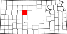 | |
| CDPs | ||
| Unincorporated communities | ||
| Ghost towns | ||
| Townships | ||
This article is issued from Wikipedia - version of the 11/17/2016. The text is available under the Creative Commons Attribution/Share Alike but additional terms may apply for the media files.