Herrick Township, Susquehanna County, Pennsylvania
| Herrick Township, Susquehanna County, Pennsylvania | |
|---|---|
| Township | |
|
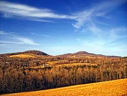
Elk Hill | |
 Map of Susquehanna County, Pennsylvania highlighting Herrick Township | |
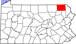 Map of Susquehanna County, Pennsylvania | |
| Country | United States |
| State | Pennsylvania |
| County | Susquehanna |
| Settled | 1789 |
| Incorporated | 1825 |
| Area | |
| • Total | 24.85 sq mi (64.4 km2) |
| • Land | 24.65 sq mi (63.8 km2) |
| • Water | 0.2 sq mi (0.5 km2) |
| Population (2010) | |
| • Total | 713 |
| • Density | 28.9/sq mi (11.3/km2) |
| Time zone | Eastern (EST) (UTC-5) |
| • Summer (DST) | EDT (UTC-4) |
| Area code(s) | 570 |
Herrick Township is a township in Susquehanna County, Pennsylvania, United States. The population was 713 at the 2010 census.
History
Herrick Township was formed from parts of Gibson and Clifford Townships on April 20, 1825.[1]
Communities
The following villages are located in Herrick Township:
Geography
According to the United States Census Bureau, the township has a total area of 24.85 square miles (64.4 km2), of which, 24.65 square miles (63.8 km2) of it is land and 0.2 square miles (0.52 km2) of it (1.24%) is water.
Demographics
2000 census
As of the census[7] of 2000, there were 599 people, 262 households, and 182 families residing in the township. The population density was 24.3 people per square mile (9.4/km²). There were 685 housing units at an average density of 27.8/sq mi (10.7/km²). The racial makeup of the township was 97.33% White, 0.50% African American, 1.00% Native American, 0.50% Asian, and 0.67% from two or more races. Hispanic or Latino of any race were 1.00% of the population.
There were 262 households out of which 27.5% had children under the age of 18 living with them, 57.6% were married couples living together, 5.7% had a female householder with no husband present, and 30.5% were non-families. 26.3% of all households were made up of individuals and 9.5% had someone living alone who was 65 years of age or older. The average household size was 2.29 and the average family size was 2.74.
In the township the population was spread out with 20.7% under the age of 18, 4.8% from 18 to 24, 26.4% from 25 to 44, 26.4% from 45 to 64, and 21.7% who were 65 years of age or older. The median age was 44 years. For every 100 females there were 105.1 males. For every 100 females age 18 and over, there were 102.1 males.
The median income for a household in the township was $31,500, and the median income for a family was $43,500. Males had a median income of $31,071 versus $21,250 for females. The per capita income for the township was $20,974. About 4.4% of families and 6.1% of the population were below the poverty line, including none of those under age 18 and 20.8% of those age 65 or over.
2010 census
As of the census[8] of 2010, there were 713 people, 308 households, and 217 families residing in the township. The population density was 28.9 people per square mile (11.3/km²). There were 749 housing units at an average density of 30.4/sq mi (11.9/km²). The racial makeup of the township was 97.3% White, 0.6% African American, 0.3% Native American, 0.3% Asian, 0.7% from some other race, and 0.8% from two or more races. Hispanic or Latino of any race were 1.4% of the population.
There were 308 households out of which 25% had children under the age of 18 living with them, 58.4% were married couples living together, 5.8% had a female householder with no husband present, and 29.5% were non-families. 25% of all households were made up of individuals and 8.7% had someone living alone who was 65 years of age or older. The average household size was 2.31 and the average family size was 2.71.
In the township the population was spread out with 18% under the age of 18, 61.7% from 18 to 64, and 20.3% who were 65 years of age or older. The median age was 49 years.
The median income for a household in the township was $58,125, and the median income for a family was $60,069. Males had a median income of $53,500 versus $37,250 for females. The per capita income for the township was $32,337. About 3% of families and 4.5% of the population were below the poverty line, including 21.1% of those under age 18 and none of those age 65 or over.
Education
Forest City Regional School District is a Preschool-12th grade public school district serving residents of Herrick Township.
References
- ↑ "Township Incorporations, 1790 to 1853". Susquehanna County Historical Society. Retrieved 9 March 2013.
- 1 2 3 "HERRICK: SECOND CLASS TOWNSHIP MAP" (PDF). Pennsylvania Department of Transportation. Commonwealth of Pennsylvania. 5 August 2011. Retrieved 20 November 2014.
- ↑ "Dimock Corners". Geographic Names Information System. United States Geological Survey. 2 August 1979. Retrieved 20 November 2014.
- ↑ "Herrick Center". Geographic Names Information System. United States Geological Survey. 2 August 1979. Retrieved 20 November 2014.
- ↑ White, Israel Charles; Dolph, John M. (1881). The Geology of Susquehanna County and Wayne County (Report). 23. Board of Commissioners for the Second Geological Survey of Pennsylvania. p. 136. Retrieved 20 November 2014.
- ↑ "Tirzah". Geographic Names Information System. United States Geological Survey. 2 August 1979. Retrieved 20 November 2014.
- ↑ "American FactFinder". United States Census Bureau. Retrieved 2008-01-31.
- ↑ "American FactFinder". United States Census Bureau. Retrieved 2011-05-14.
Municipalities and communities of Susquehanna County, Pennsylvania, United States | ||
|---|---|---|
| Boroughs | | |
| Townships | ||
| Unincorporated community | ||
Coordinates: 41°44′00″N 75°28′59″W / 41.73333°N 75.48306°W