Greenwood, Maine
| Greenwood, Maine | |
|---|---|
| Town | |
 Greenwood, Maine Location within the state of Maine | |
| Coordinates: 44°21′12″N 70°40′53″W / 44.35333°N 70.68139°W | |
| Country | United States |
| State | Maine |
| County | Oxford |
| Area[1] | |
| • Total | 43.08 sq mi (111.58 km2) |
| • Land | 41.67 sq mi (107.92 km2) |
| • Water | 1.41 sq mi (3.65 km2) |
| Elevation | 1,273 ft (388 m) |
| Population (2010)[2] | |
| • Total | 830 |
| • Estimate (2012[3]) | 828 |
| • Density | 19.9/sq mi (7.7/km2) |
| Time zone | Eastern (EST) (UTC-5) |
| • Summer (DST) | EDT (UTC-4) |
| ZIP code | 04255 |
| Area code(s) | 207 |
| FIPS code | 23-29710 |
| GNIS feature ID | 0582503 |
Greenwood is a town in Oxford County, Maine, United States. The population was 830 at the 2010 census. The town was named for surveyor Alexander Greenwood.[4] The village of Locke Mills, on State Route 26 in the northern part of Greenwood, is the town's urban center and largest settlement.
Geography
According to the United States Census Bureau, the town has a total area of 43.08 square miles (111.58 km2), of which 41.67 square miles (107.92 km2) is land and 1.41 square miles (3.65 km2) is water.[1] Noyes Mountain features a short, steep climb to the summit with excellent, panoramic views. The Harvard Quarry at the summit is a popular destination for rock and mineral collectors.
Demographics
| Historical population | |||
|---|---|---|---|
| Census | Pop. | %± | |
| 1820 | 509 | — | |
| 1830 | 695 | 36.5% | |
| 1840 | 836 | 20.3% | |
| 1850 | 1,118 | 33.7% | |
| 1860 | 878 | −21.5% | |
| 1870 | 845 | −3.8% | |
| 1880 | 838 | −0.8% | |
| 1890 | 727 | −13.2% | |
| 1900 | 741 | 1.9% | |
| 1910 | 664 | −10.4% | |
| 1920 | 605 | −8.9% | |
| 1930 | 548 | −9.4% | |
| 1940 | 564 | 2.9% | |
| 1950 | 604 | 7.1% | |
| 1960 | 601 | −0.5% | |
| 1970 | 610 | 1.5% | |
| 1980 | 653 | 7.0% | |
| 1990 | 689 | 5.5% | |
| 2000 | 802 | 16.4% | |
| 2010 | 830 | 3.5% | |
| Est. 2014 | 830 | [5] | 0.0% |
.jpg)
2010 census
As of the census[2] of 2010, there were 830 people, 362 households, and 232 families residing in the town. The population density was 19.9 inhabitants per square mile (7.7/km2). There were 810 housing units at an average density of 19.4 per square mile (7.5/km2). The racial makeup of the town was 97.2% White, 0.4% African American, 0.5% Native American, 0.2% Asian, 0.7% from other races, and 1.0% from two or more races. Hispanic or Latino of any race were 1.7% of the population.
There were 362 households of which 25.4% had children under the age of 18 living with them, 51.7% were married couples living together, 8.3% had a female householder with no husband present, 4.1% had a male householder with no wife present, and 35.9% were non-families. 28.2% of all households were made up of individuals and 8.6% had someone living alone who was 65 years of age or older. The average household size was 2.29 and the average family size was 2.79.
The median age in the town was 46.3 years. 19.9% of residents were under the age of 18; 6.1% were between the ages of 18 and 24; 21% were from 25 to 44; 37.3% were from 45 to 64; and 15.7% were 65 years of age or older. The gender makeup of the town was 50.2% male and 49.8% female.
2000 census
As of the census[8] of 2000, there were 802 people, 320 households, and 226 families residing in the town. The population density was 19.2 people per square mile (7.4/km²). There were 670 housing units at an average density of 16.0 per square mile (6.2/km²). The racial makeup of the town was 98.88% White, 0.12% African American, 0.37% Native American, 0.12% Asian, and 0.50% from two or more races. Hispanic or Latino of any race were 0.12% of the population.
There were 320 households out of which 31.3% had children under the age of 18 living with them, 58.8% were married couples living together, 8.1% had a female householder with no husband present, and 29.1% were non-families. 20.6% of all households were made up of individuals and 8.8% had someone living alone who was 65 years of age or older. The average household size was 2.51 and the average family size was 2.93.
In the town the population was spread out with 25.6% under the age of 18, 5.9% from 18 to 24, 27.1% from 25 to 44, 27.4% from 45 to 64, and 14.1% who were 65 years of age or older. The median age was 39 years. For every 100 females there were 97.5 males. For every 100 females age 18 and over, there were 87.7 males.
The median income for a household in the town was $38,750, and the median income for a family was $41,458. Males had a median income of $34,554 versus $23,750 for females. The per capita income for the town was $22,143. About 4.3% of families and 7.3% of the population were below the poverty line, including 8.2% of those under age 18 and 3.3% of those age 65 or over.
Notable people
- Leon Leonwood Bean, founder of L.L.Bean
- Nellie Verrill Mighels Davis, journalist
- Les Otten, 2010 Maine Republican Gubernatorial Candidate and founder of American Skiing Company
- Addison Emery Verrill, Yale University professor of zoology, born in Greenwood in 1839
- Anna Willard, an Olympic athlete and U.S. national champion middle distance runner
References
- 1 2 "US Gazetteer files 2010". United States Census Bureau. Retrieved 2012-12-16.
- 1 2 "American FactFinder". United States Census Bureau. Retrieved 2012-12-16.
- ↑ "Population Estimates". United States Census Bureau. Retrieved 2013-07-06.
- ↑ "Profile for Greenwood, Maine". ePodunk. Retrieved 2010-05-04.
- ↑ "Annual Estimates of the Resident Population for Incorporated Places: April 1, 2010 to July 1, 2014". Retrieved June 4, 2015.
- ↑ "Census of Population and Housing". Census.gov. Retrieved June 4, 2015.
- ↑ "Looking back at L.L. Bean from Greenwood, "a town that no longer exists"". Oxford Hills Sun Journal. Oxford Hills. July 8, 2012. Retrieved July 16, 2012.
- ↑ "American FactFinder". United States Census Bureau. Retrieved 2008-01-31.
External links
Municipalities and communities of Oxford County, Maine, United States | ||
|---|---|---|
| Towns | 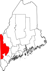 | |
| Plantations | ||
| Unorganized territories | ||
| CDPs | ||
| Other villages | ||
Coordinates: 44°19′06″N 70°39′03″W / 44.31833°N 70.65083°W
