Grand Canyon West, Arizona
| Grand Canyon West, Arizona | |
|---|---|
| CDP | |
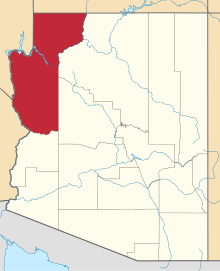
 Grand Canyon West  Grand Canyon West Location within the state of Arizona | |
| Coordinates: 35°59′59″N 114°48′37″W / 35.99972°N 114.81028°WCoordinates: 35°59′59″N 114°48′37″W / 35.99972°N 114.81028°W | |
| Country | United States |
| State | Arizona |
| County | Mohave |
| Area | |
| • Total | 17.6 sq mi (45.58 km2) |
| • Land | 17.19 sq mi (44.52 km2) |
| • Water | 0.41 sq mi (1.06 km2) |
| Elevation[1] | 4,737 ft (1,444 m) |
| Population (2010) | |
| • Total | 2 |
| • Density | 0.114/sq mi (0.045/km2) |
| Time zone | MST (UTC-7) |
| Area code(s) | 928 |
| FIPS code | 04-28985 |
| GNIS feature ID | 2582791 |
Grand Canyon West is a census-designated place (CDP) in Mohave County, Arizona, United States. The population was 2 at the 2010 census.
Geography
Grand Canyon West is located at 35°59′59″N 114°48′37″W / 35.99972°N 114.81028°W (35.999787, -113.810249). According to the United States Geological Survey, the CDP has a total area of 17.6 square miles (46 km2), 17.19 square miles (44.5 km2) of that being land, with the remaining 0.41 square miles (1.1 km2) consisting of water.[1][2]
Demographics
As of the 2010 census, there were 2 people residing in the CDP, both male. 0 were 19 years old or younger, 0 were ages 20-34, 0 were between the ages of 35 and 49, 1 was between 50 and 64, and the remaining 1 was aged 65 and above. The median age was 70.5 years.
The racial makeup of the CDP was 100% White, with 0.0% of the population being Hispanic or Latino of any race.
There were 2 households in the CDP, both non-family households (100%), with an average household size of 1.00. Both non-family households adult males living alone.
The CDP contained 19 housing units, of which 2 were occupied and 17 were vacant. [3]
References
- 1 2 "Feature Detail Report for: Grand Canyon West Census Designated Place". Geographic Names Information System. United States Geological Survey.
- ↑ "Grand Canyon West CDP, Arizona - Basic Facts". AZ Hometown Locator. Retrieved November 22, 2016.
- ↑ "American FactFinder: Grand Canyon West CDP, Arizona". United States Census Bureau. Retrieved November 21, 2016.