Crozier, Arizona
| Crozier, Arizona | |
|---|---|
| CDP | |
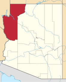
 Crozier  Crozier Location within the state of Arizona | |
| Coordinates: 35°25′22″N 113°38′55″W / 35.42278°N 113.64861°WCoordinates: 35°25′22″N 113°38′55″W / 35.42278°N 113.64861°W | |
| Country | United States |
| State | Arizona |
| County | Mohave |
| Area | |
| • Total | 1.05 sq mi (2.72 km2) |
| • Land | 1.05 sq mi (2.72 km2) |
| • Water | 0.0 sq mi (0.0 km2) |
| Elevation[1] | 3,983 ft (1,214 m) |
| Population (2010) | |
| • Total | 14 |
| • Density | 13.33/sq mi (5.15/km2) |
| Time zone | MST (UTC-7) |
| Area code(s) | 928 |
| FIPS code | 04-17460 |
| GNIS feature ID | 2582766 |
Crozier is both a census-designated place (CDP) and a populated place in Mohave County, Arizona, United States. The population was 14 at the 2010 census.
Geography
Crozier is located at 35°25′22″N 113°38′55″W / 35.42278°N 113.64861°W (35.422807, -113.648642). According to the United States Geological Survey, the CDP has a total area of 1.05 square miles (2.7 km2), all of it land. [1]
Demographics
As of the 2010 census, there were 14 people residing in the CDP: 7 male and 7 female. 0 were 19 years old or younger, 2 were ages 20-34, 0 were between the ages of 35 and 49, 7 were between 50 and 64, and the remaining 5 were aged 65 and above. The median age was 59.0 years.
The racial makeup of the CDP was 92.9% White, and 7.1% Other. 7.1% of the population were Hispanic or Latino of any race.
There were 8 households in the CDP, 4 family households (50%) and 4 non-family households (50%), with an average household size of 1.5. Of the family households, all 4 were married couples living together, while the non-family households consisted of 4 adults living alone: 2 male and 2 female.
The CDP contained 11 housing units, of which 8 were occupied and 3 were vacant. [2]