Gigondas
For the wine, see Gigondas AOC.
| Gigondas | ||
|---|---|---|
|
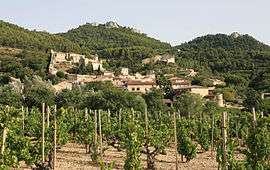
View of Gigondas and its vineyard | ||
| ||
 Gigondas | ||
|
Location within Provence-A.-C.d'A. region 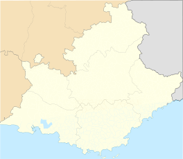 Gigondas | ||
| Coordinates: 44°09′53″N 5°00′19″E / 44.1647°N 5.0053°ECoordinates: 44°09′53″N 5°00′19″E / 44.1647°N 5.0053°E | ||
| Country | France | |
| Region | Provence-Alpes-Côte d'Azur | |
| Department | Vaucluse | |
| Arrondissement | Carpentras | |
| Canton | Beaumes-de-Venise | |
| Intercommunality | Ventoux-Comtat Venaissin | |
| Government | ||
| • Mayor (2014 - 2020) | Éric Ughetto | |
| Area1 | 27.14 km2 (10.48 sq mi) | |
| Population (2012)2 | 532 | |
| • Density | 20/km2 (51/sq mi) | |
| Time zone | CET (UTC+1) | |
| • Summer (DST) | CEST (UTC+2) | |
| INSEE/Postal code | 84049 / 84190 | |
| Elevation |
87–698 m (285–2,290 ft) (avg. 400 m or 1,300 ft) | |
|
1 French Land Register data, which excludes lakes, ponds, glaciers > 1 km² (0.386 sq mi or 247 acres) and river estuaries. 2 Population without double counting: residents of multiple communes (e.g., students and military personnel) only counted once. | ||
.svg.png)
Gigondas is a commune in the Vaucluse département in the Provence-Alpes-Côte d'Azur region in southeastern France.
Geography
Gigondas lies in between Vacqueyras and Sablet at the foot of the Dentelles de Montmirail mountains.
Wine
While the village was very famous for its 'eau purgative de Montmirail' in the 19th century, it is now home to famous wines. Gigondas AOC wine is produced in Gigondas.
See also
References
| Wikimedia Commons has media related to Gigondas. |
This article is issued from Wikipedia - version of the 2/11/2016. The text is available under the Creative Commons Attribution/Share Alike but additional terms may apply for the media files.