Giant current ripples
Giant current ripples are active channel topographic forms up to 20 m high, which develop within near-talweg areas of the main outflow valleys created by glacial lake outburst floods. Giant current ripple marks are morphologic and genetic macroanalogues of small current ripples formed in sandy stream sediments.
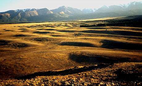
The giant current ripple marks are important depositional forms in diluvial plain and mountain scablands.[1]
History of the research

The history of the scabland studies has two distinct stages: the "old" one that began with the first works by J Harlen Bretz and Joseph Pardee in North America and lasted until the end of the 20th century that was crowned with the discovery of giant current ripple marks in Eurasia, and a "new" one. The latter is associated with heated debates concerning the genesis of the relief under study and which involved a lot of Russian geologists, geomorphologists and geographers. The discussion about the origin of the giant ripples dealt at least to a certain extent with every aspect of the diluvial theory, from the genesis of the lakes themselves, their existence duration, possibilities of their cataclysmic failures, etc. to the origin of the diluvial forms - the aspects that have been accepted by many scientists worldwide, including an increasing number of Russian scientists.
The state of the problem in the 20th century. "Old hypotheses"
J Harlen Bretz, author of the hypothesis of the diluvial origin of the Channeled Scabland, considered mainly "giant gravel bars" (diluvial ramparts and terraces) among the diluvial-accumulative formations as a proof of his case along with the destructive forms of the scabland (gorges-coulees, waterfall cataracts – chains of erosional dry falls washed of loose sediments by the floods of diluvial farewell rocks).[2][3][4]

It was only after J. T. Pardee's report in Seattle at the Session of the American Association for the Advancement of Science in 1940[5] that the expression "giant current ripples" was introduced in the modern meaning. J. Pardee gave brief characteristics to the forms found by him already in the early 20th century while researching the Late Pleistocene lake Missoula.[6] J. Pardee, who was the discoverer of this lake and named it, had kept silent for over thirty years until his retirement about cataclysmic outbursts of the giant North-American ice-dammed lakes in the Pleistocene. As already mentioned, the "official" American geology represented by the United States Geological Survey, which strictly controlled all scientific studies, strongly objected to J H. Bretz's hypothesis in the early 20th century. J. Pardee was a member of this organization. Even the title "Ripple marks (?) in the glacial lake Missoula" of Pardee's report proves the great significance attached by Pardee to the relief he discovered a few decades ago as an instrument for the reconstruction of Late Quaternary diluvial palaeohydrology in North America. Thus, it is this scientist's name that we should associate with the discovery and correct genetic interpretation of the relief of giant current ripples. After Pardee's publication in 1942, giant current ripples have been found practically everywhere on the territory of the basaltic Columbia Plateau (this was the direction of the cataclysmic outbursts of Missoula and other ice-dammed lakes).
A special study of the geomorphology and palaeohydrology of the American scabland was begun by Victor Baker.[7] It was Baker who mapped all main fields of giant current ripples known today in America, and it was he who made first attempts to gain chief hydraulic characteristics of the Missoula floods according to the multiple measurements of paired parameters of diluvial dunes and their mechanical composition.[8] Some other so far known means had certainly been used for the purpose as well since Bretz's times, in particular, the functional dependences by Schezi and Manning. However, those dependences estimated velocities and discharges of the floods at the channel line, and the data received, although imprecise, were tremendous. V. R. Baker calculated the palaeohydraulic data over the ripple fields, i.e. over the sites distanced from the channel line and (or) on wane of the floods, where the current velocities of the diluvial streams admittedly must have been less than maximum ones (all the same, they were hundreds of thousands of cubic metres per second).

For nearly sixty years the well-known ice-dammed Lake Missoula (and other well-known North-American ice-dammed lakes) and its cataclysmic outbursts was considered as a unique one in the world's scientific literature. Special tourist routes were organised at most impressive sites of "giant vessels", canyons-coulees, vast fields of giant current ripples and others. Here professional guides tell the tourists about hydrospheric catastrophes which took place in the ice ages in America.

The discovery of the relief of giant current ripples in the Altai and Tuva and its correct diagnostics began a new stage in the paleogeographical research of the continents, a broad international cooperation and initiated new conclusions which have cleared up a lot of questions in the Quaternary geology and Paleohydrology of Pleistocene in Eurasia.
Along with the development of the ideas about enormous dimensions and a big role of Pleistocene glacier-dammed lakes and their cataclysmic outbursts, a new branch of the scientific research which was called by the British geologist P. A. Carling "flood deposit sedimentology"[9] is becoming more and more notable. In Russia in the middle 1990s the geological objects formed by the diluvial floods — floodstreams — were referred by the author to the research objects of Quaternary glaciohydrology based on the theory of the diluvial morpholithogenesis.[10]
In Russia nobody had known anything about the regime of ice-dammed lakes until the 1980s and, of course, had not looked for any traces of their failures, either. Although some lake terraces of the basinal preglacial bodies of water in the mountains of South Siberia were mapped in the early 20th century (it was done incidentally during some geological and botanical investigations), the question of the evacuation mechanisms of these lakes did not even arise. As a matter of fact, this question was (and by someones is still) considered rhetorical: since there are strandlines on the sides of the depressions, then the lakes used to dry gradually and slowly. Moreover, in some authors' opinions, the lakes appeared in the depressions, in particular in the Altai, only once, at the most – twice. And when such lake terraces could be poorly distinguished, if any at all, in the depressions, then the question of the lakes did not arise: there were not any lakes.
Nevertheless, in the late 1950s G. F. Lungershausen and O. A. Rakovets[11] were the first to give a correct interpretation to a "mysterious" ridge-and-pading relief in Kuray intermountain depression. These scientists were the first to correctly define the genesis of the relief in the depression and to assume, according to the orientation of the diluvial dunes, the eastern direction of the runoff of the rivers, which is opposite to the contemporary one, at some moment in the history of the Altai. The genetic diagnostics of the giant ripples in the Kuray Basin had a general character and was essentially limited to the terminologically correct definition only (in fact, the purpose of the article of the authors mentioned was different). The article explained the origin of the direction of the water torrents proper by some neotectonic reasons.
New hypotheses of the origin of the giant current ripple marks

The notice made by G.F. Lungershausen and O.A. Rakovets about the diluvial origin of giant ripple marks in Kuray was denied by E.V. Deviatkin,[12] who referred to an oral conclusion made by E.V. Shantser and wrote that the large ripple marks in Kuray Basin were results of heavy erosional processing of a huge fluvioglacial fan. M.V. Petkevich expressed a similar opinion in her candidate thesis. She believed that the ridged relief on the right bank of the Tetio River in Kuray Basin was a washed proluvial fan.[13]
Every single diagnostic sign of the giant ripples given in the corresponding section contradict this theory, especially the cross-layered texture of the sediments in the ripple marks which correlates with their morphology and the regular asymmetry of their slopes at all the locations. The petrography composition of the coarse-fragmental material in the ripple marks witnesses also against this hypothesis, it is alien to the bed rock of the basins of the Tetio and the Aktru rivers.
In addition, G.G. Rusanov[14] found malachite, axinite, sillimanite and cinnabar in the schlichs of the ripple marks in Kuray Basin, which are characteristic of the Kuray Ridge but not found in the schlichs of the end moraines of the Tetio River, the latter adjoining the fields of the giant ripples. Cinnabar is a heavy, fragile and quickly worn mineral. That is why, as G.G. Rusanov remarks, it cannot be carried away from its original source farther than over first hundreds of metres. Over longer distances this mineral can be transported only in suspension state. At the same time, galena, which is very characteristic of the moraines of the Tetio and the Aktru Valleys, is not found in the ripple sediments. Hence, pebble deposits adjoining the end moraines of the Tetio cannot be fluvioglacial or proluvial formations of the meltwater from the glaciers of the Aktru and the Tetio.
At that time P.A. Okishev flatly disagreed with his predecessors and contemporaries. He argued that the proofs of the erosional extension of a vast fluvioglacial fan here (in Kuray Basin) are unconvincing. In 1970 P.A. Okishev put forward the idea that the giant current ripple marks in Kuray depression are "inversional formations". "The ridges presently expressed in the relief used to accumulate as channel sediments within above-glacial floods of a vast flat glacial field and projected afterwards onto the substratum" (,[15] p. 49).
A. N. Rudoy shall point out in this quotation that 1) P.A. Okishev simply described, though superficially, the mechanism of the eskers, and 2) he emphasised the fluvial, channel origin of the ridges proceeding from their material composition and morphology.[16] This investigator developed his theory later in his book[17] and his doctoral thesis (1984), but practically at the same time he put forward another hypothesis, a "glacial" one, without explaining anything or mentioning the "inversional relief". P.A. Okishev wrote that the giant current ripples in Kuray Basin are "bedded, small-ridged, poly-ridged" moraines. The "inversional relief" was forgotten by the author for ever and has never been mentioned again. This author's unclear explanations of the essence of his second "moraine" hypothesis (he would have a third one as well) may be regarded in general as an attempt "to introduce something new" into the works by B.A. Borisov and E.A. Minina who, after many years of their geological surveys in the mountains of southern Siberia, discovered and described the relief of "a washing board" (the phase of the rogen moraine according to the classification by Yu. A. Lavrushin.[18] B.A. Borisov and E.A. Minina ascribed the relief of giant current ripples of all the districts where it had been found, described and more or less studied to that relief of the ribbed moraine,[19] the latter really exists in many ancient glacial mountainous valleys of Siberia, Middle Asia and in other mountains.
The first investigator in Russia who not only correctly defined the genesis of the giant current ripples (we shall remind that this was done first by G.F. Lungershausen and O.A. Rakovets about twenty-five years before that time) but also described their composition and reconstructed (in a complex with other flood forms) palaeoglaciohydrology of the region of the geological surveys was V.V. Butvilovsky. However, his discovery was made far from the region where nowadays "lances are being broken". It was in the valley of the Bashkaus River in the Easter Altai[20]]. As a matter of fact, V.V. Butvilovsky managed to describe the whole palaeohydrologic scenario of the last glacial age based on a small district, which corresponds well to the modern ideas about glacial palaeohydrology of the dryland. He also showed that the Quaternary ice-dammed lake of Tuzhar Village discovered by him outburst into the valley of the Chulyshman River after having reached its critical level. He emphasised that in the valley of the Bashkaus River and the Chulyshman River there was only one but very powerful superflood with its maximum discharge of about 880 000 m3/s (the calculation was done according to the formula by Schezi). Later on, V.V. Butvilovsky developed his ideas and defended them in his doctoral thesis [Butvilovsky, 1993].
When working in the Central and South-Eastern Altay, A. N. Rudoy studied in this years the largest in the Altay ice-dammed lakes of Chuya, Kuray and Uymon Basins[21] (Butvilivsky was in the 1970s his student in Tomsk State University). In autumn 1983 Rudoy carried out some field research on the left bank site of the Katun River which is now known as "the field of giant current ripples of Platovo-Podgornoje". The result of the research was the first published work dedicated to the multiple cataclysmic outbursts of those tremendous Pleistocene ice-dammed lakes.[22] That work was the first to give a detailed description of the structure of the relief of the giant current ripples at the foothills. Also the first attempt was made to define the palaeohydraulic characteristics of the diluvial floods according to the morphologic peculiarities of the ripples and their material composition.

In the early and middle 1980s special filed studies headed by the Alexei Rudoy were carried out at the discovered sites of the fields of the giant current ripples, four of which have become key ones in the course of time, i.e. they have been specially studied for many years by professionals from different countries and of different specialities. These key sites include: the location of giant current ripples of Platovo-Podgornoje; the location of diluvial dunes of the Little Yaloman – the Inia; the field of the giant current ripples in the central part of Kuray Basin and the diluvial dunes at the Basin (in Russian: urochishtshe) Kara-Kol on its western raised periphery.

Some reconstruction of the regime of the last glacial age, estimates of the glacial runoff at its maxima and post-maxima, on the one hand, and the discovery of the diluvial morpholithocomplex on the other hand, enabled us already at the late 1980s to outline a common palaeoglaciohydrologic situation of the Glacial Pleistocene for those territories of the Earth where the oroclimatic condition were similar to those of the mountains of Siberia. At the same time M.G. Grosswald[23] described and physically interpreted for the first time fields of giant current ripples not in the Altai only but also in the intermountain depressions of Tuva and in the valleys of the Upper Yenisei. Nowadays these fields are also studied by international expeditions, some works paying a special attention to the giant ripple marks on the Sayany-Tuva table-land have been already published.[24]
In early 1990s first international expeditions which specially studied the diluvial morpholithologic complex in Asia. Their purpose was to compare main palaeohydromorphologic characteristics of mountain scablands of Central Asia which had been already developed in Russia by that time[25] with those of the known plain diluvial associations of the Channeled Scabland territory in North America. The participants of those first expeditions were specialists from Russia (M.R. Kirianova, A.N. Rudoy), the United States (V.R. Baker), Great Britain (P.A. Carling), Germany (K. Fischer and M. Kuhle) and Switzerland (Ch. Siegenthaler).[26]
In the second half of 1990s and at the beginning of the 21st century (until the field season of 2010) P.A. Carling carried out some more special expeditions in the Altai, their results were summed up in a cooperative work.[27]
Later, a group of German sedimentologists under the direction of Ju. Herget worked successfully in the Altai. Several big articles presented the refined data of the palaeohydraulic parameters of the diluvial floods in the river valleys of the Chuya River and Katun River.[28]
In 1998 S.V. Parnachov defended his candidate thesis based on the analysis of some well-known sections of the diluvial terraces at the Katun River and the Chuya River, as well as on the data by P.A. Carling and conclusions of his own. The thesis paid a certain amount of attention to the key locations of the fields of giant current ripples discovered before. The investigator fulfilled, in particular, the petrographic and granulometric analyses of the clastic material of the giant ripples at the key sites. S.V. Parnachov based himself on the calculations of the jökulhlaup discharges by P.A. Carling – 750,000 m3 per second – and came to the conclusion that there were no fluvial catastrophes but there were several lake outbursts with the discharges not higher than those of contemporary big rivers. Instead of the diluvial sediments this author suggested a new geological formation – the "flood alluvium".[29]
Consequently, S.V. Parnachov distinguished the "flooding period" in the Altay of about 150 000 years long. The genesis of the basinal lakes, however, S.V. Parnachov admitted so far as ice-dammed one. Two years later I.S. Novikov joined the investigations by S.V. Parnachov.[30] These geologists drew a conclusion that "the glaciers could not" dam themselves such big lake depressions, consequently the dams were "ice-tectonic" ones. So, according to the authors quoted, during the "flooding period" that lasted for about 150 000 years there were no less than seven cataclysmic flooding occurrences associated with the outbursts of the palaeolakes. Moreover, a tectonic obstacle also played a role in the damming of the lakes during the very last degradation phases of the Würm glacier.
Alternate explanations
"New antidiluvialists" have put forth alternate explanations to the giant current ripples theory.[31]
- The giant current ripples in the valleys of the Altai (except Kuray depression) are ordinary ripples like contemporary river dunes of large rivers (i.e. – "nothing special"). The author of the quotation is A.V. Pozdniakov who observed some forms of such ripples in the valleys in the Far East. He was joined by D.A. Timofeev[32] and some participant of a school-seminar of the geography Committee of the Russian Academy of Sciences,[33] including G. Ya. Baryshnikov who, 10 years earlier, proved the cataclysmic origin of the giant current ripple marks at the foothills of the Altai and at the middle reaches of the Katun.
- The giant current ripples in Kuray depression are ripples but they developed "under the conditions which were similar to or slightly different from the contemporary ones, and not on the bottoms of the deep pre-glacial lakes which outburst catastrophically". Quoted from an essay in "The Geomorphology" written by G. Ya. Baryshnikov and others with references to the opinion of the participants of the above-mentioned school-seminar adopted after the discussion.
- The giant current ripples in Kuray depression are not ripples at all but the consequence of a meteorite fall.
- The giant current ripples in Kuray depression are not ripples at all but the consequence of an earthquake. These hypotheses contain both elastic vibrations and cryptoexplosion structures… The authors are A.V. Pozdniakov and A.V. Khon.[34]
- The giant current ripples in Kuray depression are cryogenic erosional formations. The authors are A.V. Pozdniakov and A.V. Khon again, also P.A. Okishev.[35]
Megaflooding on Earth and Mars

While the Russian science is discussing the genesis of the giant current ripples at the just briefly described scientific level, American and British geologists and planetologists have discovered such relieves on Mars according to the data on the giant current ripples in the Altai and even calculated the hydraulic parameters of those diluvial floods.[37]
Main diagnostic features of the giant current ripple marks
Up to the present, hundreds of locations of the fields of giant current ripples have been discovered in North America and Northern Asia. Here is a brief description of main characteristics of this relief and its sediments at the key, today most often visited, sites in the Altai and Tuva with the necessary references to the chief publications for the other territories.
- Wave height from 2–20 m with the wavelength from 5–10 m to 300 m
- Ripple marks are stretched transversely to the diluvial floods. They are clearly and regularly asymmetric. The proximal slopes are orientated towards the flood, they are more gentle with slightly prominent profiles (The profile of "the whale back"); the distal slopes are steeper with slightly concave profiles nearer to the crest
- Big poorly rounded boulders and blocks are often to be found at pre-crest and upper part of the slopes
- Giant current ripple marks are constituted by deposits of pebbles and small boulders with a low percentage of coarse- and big-grained sand. The fragmentary material is diagonally cross-bedded agreed with the dip of the distal slope. Irrespective of the age of the ridges (normally, it is the time of the last late- and post-glacial age) the sediments are loose and dry, fragments are not hardened with loamy and silt.
- Fields of giant current ripples are situated close to the run-off ways from basinal ice-dammed lakes and to vortex zones within valley expansions[38]
Unfortunately, no diagnostic features of the lithology of giant current ripples have been cleared up, yet, that could differentiate the latter from other genetic types of loosed sediments in sections. The presence of cross-bedded series in some layers with evidently fluvial genesis which were diagnosed by V.V. Butvilovsky as buried ripples (e.g. an exposure in a pit near the mouth of the Isha River, etc.) does not look as remarkable in the nature as it is described by the author. A. N. Rudoy used to work for a long time at this and similar exposures (e.g. by the settlement of Karlushka). Nothing, except the fact of the cross dipping of fluvial boulder pebbles, can tell the investigator that he sees some buried giant current ripples. One can nothing but assume this. And an abrupt dipping of bedded alluvial channel fractions is a very often seen phenomenon. The problem of diagnosing diluvial sediments in a buried state, i.e. without any geomorphological control, may apparently be solved not only, if at all, by studying peculiarities of the diluvial texture, but by means of the microscopic lithological studies of the sediments of giant current ripples, i.e. mineralogy of fine fractions, grain shapes, analysis of accessories, etc. Then these correctly summarised data must be compared with various phases of the contemporary mountainous alluvium at the analogous sections.
See also
References
- ↑ Alexei N. Rudoy, 2005. Giant current ripples (History of the Research, their diagnostics and palaeogeographical significance). - Tomsk. - 224 pp. In Russian, Eng. summary: pp. 134-211 pp.
- Рудой А. Н. Гигантская рябь течения (история исследований, диагностика и палеогеографическое значение) // Материалы гляциологических исследований, 2006. — Вып. 101. — С. 24-48.
- ↑ Bretz, J.H. The Channeled Scabland of the Columbia Plateau, Geol. Soc. Am. Bull., 1923. - Vol. 31.- p. 617-649
- ↑ Bretz, J. H., The Spocan beyond the Channeled Scabland, J. Geol, 1925. V. 33. p. 97-115
- ↑ Bretz, J.H., Smith H.T.,U., Neff G.E.,Channeled Scabland of Washington; new data and interpretations, Geol. Soc. America Bull., 1956. - V. - 67. P. 957-1049
- ↑ Pardee, J. T., Unusual currents in glacial Lake Missoula, Montana, Geol. Soc. Am. Bull., 1942. - V. 53. - P. 1569-1600.
- ↑ Pardee, J.T., The glacial Lake Missoula, Montana, J. Geol., 1910.- V. 18. - P. 376-386.
- ↑ Baker, V. R. Paleohydrology and sedimentology of Lake Missoula Flooding in Eastern Washington, Gel. Soc. Am. Spec. Pap., 1973. - V. 6. - 79 p.
- ↑ Baker, V. R. and D. Nummedal, The Channeled Scabland, NASA, Washington, D.C., 1978. - 186 p.
- ↑ Carling P. A., Kirkbride A.D., Parnachov S.P et al. Late Quaternary catastrophic flooding in the Altai Mountains of south-central Siberia: a Synoptic overview and an introduction to the flood deposit sedimentology / Eds. P.I. Martini, V.R. Baker, G. Garson. – In: Flood and megaflood processes and deposits: resend and ancient examples // Int. Ass. of Sedimentologists. Oxford, England, 2002. Spec. Publ. 32. p. 17-35.
- ↑ Рудой А.Н. Основы теории дилювиального морфолитогенеза // Известия Русского географического общества, 1997. Том. 129. Вып. 1. С. 12-22.
- ↑ Лунгерсгаузен Г.Ф., Раковец О.А. Некоторые новые данные о стратиграфии третичных отложений Горного Алтая // Тр. ВАГТ, 1958. Вып. 4. 1958. С. 79-91.
- ↑ Девяткин Е.В. Кайнозойские отложения и новейшая тектоника Юго-Восточного Алтая // Тр. ГИН АН СССР, 1965. - Вып. 126. - 244 с.
- ↑ Петкевич М.В. Физико-географические аспекты развития склоновых процессов в Центральном Алтае / Дисс… канд. географ. наук. Томск: Томск. ун-т, 1973. 180 с.
- ↑ Русанов Г.Г. О новых гипотезах происхождения грядового рельефа в Курайской котловине Горного Алтая // Природные ресурсы Горного Алтая. - Горно-Алтайск, 2004. - № 2. - С. 48–53.
- ↑ Окишев П.А. Некоторые новые данные о древнем оледенении Алтая // Доклады Томского отдела Русского географического общества. - Ленинград, 1970.- С. 44-60.
- ↑ Rudoy A.N. Glacier-Dammed Lakes and geological work of glacial superfloods in the Late Pleistocene, Southern Siberia, Altai Mountains // Quaternary International, 2002. Vol. 87/1. pp. 119–140
- ↑ Окишев П.А. Динамика оледенения Алтая в позднем плейстоцене и голоцене. – Томск: Томск. университет, 1982. 209 с.
- ↑ Лаврушин Ю.А. Строение и формирование основных морен материковых оледенений. – М.: Наука, 1976. 238 с.
- ↑ Борисов Б.А., Минина Е.А. Ледниковые отложения Алтае-Саянской горной области. - Хронология плейстоцена и климатическая стратиграфия. Л.: Наука, 1973. - С. 240–251.
- Борисов Б.А., Минина Е.А. О гипотезе катастрофических гляциальных паводков на территории Алтае-Саянской области в свете геолого-геоморфологических данных // Всероссийское совещание «Главнейшие итоги в изучении четвертичного периода и основные направления исследований в ХХI веке». СПб, 1998. С. 90-91.
- ↑ Бутвиловский В.В. О следах катастрофических сбросов ледниково-подпрудных озер Восточного Алтая // Эволюция речных систем Алтайского края и вопросы практики. - Барнаул, 1982. С. 12–17.
- ↑ Рудой А.Н. К истории приледниковых озер Чуйской котловины (Горный Алтай). – Материалы гляциологических исследований. Хроника, обсуждения, 1981. Вып. 41. С. 213–218.
- Рудой А.Н. Некоторые вопросы палеогеографический интерпретации литологии и особенностей распространения озерно-ледниковых отложений Горного Алтая // Гляциология Сибири, 1981. Томск: Томский ун-т. Вып. 1 (16). С. 111–134.
- Рудой А.Н. К диагностике годичных лент в озерно-ледниковых отложениях Горного Алтая // Изв. Всесоюзного географического общества, 1981. Т. 113. Вып. 4. С. 334–340.
- Рудой А.Н. Гигантская рябь течения - доказательство катастрофических прорывов гляциальных озер Горного Алтая / Научн.-практ. конф. "Современные геоморфологические процессы на территории Алтайского края". - Бийск, 1984. - С. 60-64.
- ↑ Рудой А.Н. Гигантская рябь течения – доказательство катастрофических прорывов гляциальных озер Горного Алтая // Тр. конф. «Современные геоморфологические процессы на территории Алтайского края». - Бийск, 1984. - С. 60–64.
- ↑ Grosswald M.G., Rudoy A.N. Quaternary Glacier-Dammed Lakes in the Mountains of Siberia // Polar Geography, 1996. - Vol.20. - Iss.3._- P.180–198.
- ↑ Гросвальд М.Г. Евразийские гидросферные катастрофы и оледенение Арктики. – М.: Научный мир, 1999, 120 с.
- Гросвальд М.Г. Оледенение и вулканизм Саяно-Тувинского нагорья // Изв. РАН. Сер. географическая, 2003. - № 2. - С. 83-92.
- Гросвальд М.Г., Рудой А.Н. Ледниково-подпрудные озера в горах Сибири // Изв. РАН. Сер. географическая, 1996. - № 6. - С. 112-126.
- Лукина Н.В. История Дархатского палеоозера в свете корреляции событий плейстоцена Азии // Стратиграфия и корреляция четвертичных отложений Азии и Тихоокеанского региона / Ред. Г.И. Худяков. - М.: Наука, 1991. - С. 85–90.
- Goro Komatsu,, Sergei G. Arzhannikov, Alan R. Gillespie, Raymond M. Burke, Hideaki Miyamoto, Victor R. Baker. Quaternary paleolake formation and cataclysmic flooding along the upper Yenisei River // Geomorphology, 104. (2009). - P. 143–164.
- ↑ Рудой А.Н. Дилювий: процесс, терминология, рельеф и отложения // Всесоюзное совещание «Четвертичная геология и первобытная археология Южной Сибири». - Улан-Удэ: Бурятский филиал СО АН СССР, 1986.
- Рудой А.Н. Концепция дилювиального морфолитогенеза. – Стратиграфия и корреляция четвертичных отложений Азии и Тихоокеанского региона / Тез. Межд. симп. Находка-Владивосток, 1988. - Т.2. - С. 131–132.
- Rudoy A.N. Fundamentals of the Theory of diluvial Morpholithogenesis / Abstr.13th INQUA Congr. Beijing, 1991. - P. 131–132.
- ↑ Baker V.R., Benito G., Rudoy A.N. Palaeohydrology of late Pleistocene Superflooding, Altay Mountains, Siberia // Science. 1993. - Vol. 259. - pp. 348–351.
- Rudoy A.N., Baker V.R. Sedimentary Effects of cataclysmic late Pleistocene glacial Flooding, Altai Mountains, Siberia // Sedimentary Geology, 1993. - Vol. 85.- N 1-4.- pp. 53–62.
- ↑ Carling P.A., Kirkbride A.D., Parnachov S.P et al. Late Quaternary catastrophic flooding in the Altay Mountains of south-central Siberia: a Synoptic overview and an introduction to the flood deposit sedimentology / Eds. P.I. Martini, V.R. Baker, G. Garson. – In: Flood and megaflood processes and deposits: resend and ancient examples // Int. Ass. of Sedimentologists. Oxford, England, 2002. Spec. Publ. 32. pp. 17–35.
- ↑ Herget, J. Reconstruction of Ice-Dammed Lake Outburst Floods in the Altai-Mountains, Siberia – A Reviev // Geol. Soc. India, 2004. Vol. 64. P. 561-574.
- Herget J.& Agatz H. Modelling ice-dammed lake outburst floods in the Altay Mountains (Siberia) with HEC-RAS. – V.R. Thorndycraft, G. Benito, M. Barriendos and M.S. Llasat 2003. Palaeofloods, Historical Floods and Climate Variability: Application in Flood Risk Assessment, (Proc. of the PHEFRA Workshop, Barselona, 16-19th Okt., 2002)
- ↑ Парначев С.В. Геология высоких алтайских террас (Яломано-Катунская зона). - Томск: Томск. политехнический университет, 1999. - 137 с.
- ↑ Новиков И.С., Парначев С.В. Морфотектоника позднечетвертичных озер в речных долинах и межгорных впадинах Юго-Восточного Алтая // Геология и геофизика, 2000. - Т. 41. - № 2. - С. 227–238.
- ↑ Новиков И.С., Парначев С.В. (2000), "Морфотектоника позднечетвертичных озер в речных долинах и межгорных впадинах Юго-Восточного Алтая", Геология и геофизика (41, number 2): 227–238,
affords doubts as for the ideas about the cataclysmic character of the drainage processes of the depressions which have become so popular in the scientific literature for the last decade
- ↑ Тимофеев Д.А. Размышления о философии геоморфологии // Геоморфология, 2003. - № 4. -С. 3-8.
- ↑ Барышников Г.Я., Платонова С.Г., В.П. Чичагов. Геоморфология гор и предгорий // Геоморфология, 2003. - № 1. - С. 108–109.
- ↑ Поздняков А.В., Хон А.В. О генезисе «гигантской ряби» в Курайской котловине Горного Алтая // Вест. Томского университета (Гляциология Сибири), 2001. - № 274. - С.24–33.
- ↑ Поздняков А.В., Окишев П.А. Механизм формирования донных гряд и возможный генезис «гигантской ряби» Курайской котловины Алтая // Геоморфология,2002. - № 1. - С. 82–90.
- ↑ Athabasca-video in large Scale.
- ↑ Paul A. Carling, I . Peter Martini, Juergen Herget a.o. Megaflood sedimentary valley fill: Altai Mountains, Siberia. — Megaflooding on Earth and Mars / Ed. Devon M. Burr, Paul A. Carling and Victor R. Baker. Published by Cambridge University Press, 2009. - P. 247–268.
- ↑ Рудой А.Н. Гигантская рябь течения (история исследований, диагностика и палеогеографическое значение) – Томск: ТГПУ, 2005. - 228 с. (Abstr. in eng. on pp. 134-221).
External links
- Alexei N. Rudoy, 2005. Giant current ripples (History of the Research, their diagnostics and palaeogeographical significance). - Tomsk. - 224 pp. In russian, eng. summary: pp. 134-211 pp.
- Chuya Flood Video
- The channeled scabland: a guide to the geomorphology of the Columbia Basin, Washington : prepared for the Comparative Planetary Geology Field Conference held in the Columbia Basin, June 5–8, 1978 / sponsored by Planetary Geology Program, Office of Space Science, National Aeronautics and Space Administration ; edited by Victor R. Baker and Dag Nummedal.
- Carling P.A. Morphology, sedimentology and palaeohydraulic significance of large gravel dunes, Altai Mountains, Siberia // Sedimentology, 1996. — V. 43. — P. 647—664.
- Missoula Flood Giant Current Ripples at Wikimapia
- Keenan Lee. The Altai Flood
- Keenan Lee. The Missoula Flood
- А.Н. Рудой. Ледниковые катастрофы в ледниковой истории Земли // Природа, 2000. - № 9.
- Rudoy, A. N.; Chernomorets, S. S. Giant Current Ripple Marks: Remote Sensing of New Locations on the Earth. / Second International Planetary Dunes Workshop: Planetary Analogs — Integrating Models, Remote Sensing, and Field Data, held May 18-21, 2010 in Alamosa, Colorado. LPI Contribution No. 1552. — P.57-58.
- Richard John Huggett. Fundamentals of Geomorphology (PP. 246-247, 271). Second Edition. London: Routledge Fundamentals of Physical Geography, 2007. — 483 p.
- Рудой А. Н., Земцов В. А. Новые результаты моделирования гидравлических характеристик дилювиальных потоков из позднечетвертичного Чуйско-Курайского ледниково-подпрудного озера.
- Diluvium Video
- Athabasca-video in large Scale
- Alexei Rudoy. Giant current ripples: A Review (Гигантская рябь течения: обзор новейших данных). 29. 12. 2010.
- Alexei Rudoy. Giant gravel bars - дилювиально-аккумулятивные валы ("высокие террасы").
- А. Н. Рудой. Study diluvium: general provisions. Общие положения учения о дилювии.
