Georgia State Route 182
| ||||
|---|---|---|---|---|
| River Road | ||||
 | ||||
| Route information | ||||
| Maintained by GDOT | ||||
| Length: | 8.70 mi[1][2] (14.00 km) | |||
| Major junctions | ||||
| West end: |
| |||
| East end: |
| |||
| Location | ||||
| Counties: | Ben Hill | |||
| Highway system | ||||
| ||||

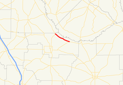
State Route 182 (SR 182) is a 8.7-mile (14.0 km) state highway that runs west–east through northern Ben Hill County in the south-central part of the U.S. state of Georgia.
Route description
The route begins at an intersection with US 129/SR 11 north of Fitzgerald. It travels southeast to its eastern terminus at an intersection with US 319/SR 107 northeast of Fitzgerald. The route, named River Road, runs parallel to the Ocmulgee River for its entire length.[3][2]
Major intersections
The entire route is in Ben Hill County.
| Location | mi[2] | km | Destinations | Notes | |
|---|---|---|---|---|---|
| Bowens Mill | 0.0 | 0.0 | Western terminus | ||
| | 8.7 | 14.0 | Eastern terminus | ||
| 1.000 mi = 1.609 km; 1.000 km = 0.621 mi | |||||
See also
-
.svg.png) Georgia (U.S. state) portal
Georgia (U.S. state) portal -
 U.S. Roads portal
References
- ↑ Office of Information Services (December 31, 2002). "State Highway System Mileage in Each County Classified by State Route Number and Federal-Aid System" (PDF). Georgia Department of Transportation. Archived from the original (PDF) on September 26, 2007. Retrieved January 8, 2013.
- 1 2 3 Google (June 9, 2013). "Route of SR 182" (Map). Google Maps. Google. Retrieved June 9, 2013.
- ↑ General Highway Map - Ben Hill County, Georgia (PDF) (Map). Georgia Department of Transportation. 2008. Retrieved January 8, 2013.
External links
This article is issued from Wikipedia - version of the 9/14/2016. The text is available under the Creative Commons Attribution/Share Alike but additional terms may apply for the media files.