Trams in Görlitz
 Tatra KT4D-C no. 308 at Görlitz station, 2010. | |||||||||||||||||||
| Operation | |||||||||||||||||||
|---|---|---|---|---|---|---|---|---|---|---|---|---|---|---|---|---|---|---|---|
| Locale | Görlitz, Saxony, Germany | ||||||||||||||||||
| |||||||||||||||||||
| |||||||||||||||||||
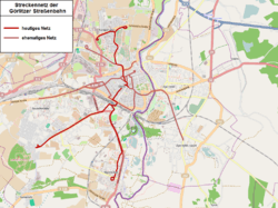
The Görlitz tramway network (German: Straßenbahnnetz Görlitz) is a network of tramways forming part of the public transport system in Görlitz, a city in the federal state of Saxony, Germany.
Opened in 1882, the network has been operated since 1996 by Verkehrsgesellschaft Görlitz (VGG).
Lines
As of 2013, the network had the following lines:[1]
| Line | Route | Stops | Journey time | Headway (rush hour) | Headway (evenings) |
|---|---|---|---|---|---|
| |
Biesnitz/Landeskrone – Bahnhof – Demianiplatz – Alexander-Bolze-Hof – Königshufen Am Wiesengrund | 17 | 24/25 min | 20 min | - |
| |
Weinhübel – Bahnhof – Demianiplatz – Alexander-Bolze-Hof – Königshufen Am Marktkauf / (– Königshufen Am Wiesengrund) (the Königshufen termini alternate in the evenings) | 17 | 24/25 min | 20 min | 30 min |
See also
References
Notes
- ↑ "Linien-Übersicht". VGG website (in German). Verkehrsgesellschaft Görlitz. Retrieved 27 December 2013. External link in
|work=(help)
Bibliography
- Bauer, Gerhard; Kuschinski, Norbert (1993). Die Straßenbahnen in Ostdeutschland [The Tramways in East Germany]. Band 1: Sachsen [Volume 1: Saxony]. Aachen, Germany: Schweers + Wall. ISBN 3921679796. (German)
- Schwandl, Robert (2012). Schwandl's Tram Atlas Deutschland (in German and English) (3rd ed.). Berlin: Robert Schwandl Verlag. p. 66. ISBN 9783936573336.
External links
![]() Media related to Trams in Görlitz at Wikimedia Commons
Media related to Trams in Görlitz at Wikimedia Commons
- Görlitz database / photo gallery and Görlitz tram list at Urban Electric Transit – in various languages, including English.
- Görlitz database / photo gallery at Phototrans – in various languages, including English.
| Baden-Württemberg |  | |
|---|---|---|
| Bavaria | ||
| Berlin | ||
| Brandenburg |
| |
| Bremen | ||
| Hesse | ||
| Lower Saxony | ||
| Mecklenburg-Vorpommern | ||
| North Rhine-Westphalia | ||
| Rhineland-Palatinate | ||
| Saarland | ||
| Saxony | ||
| Saxony-Anhalt | ||
| Thuringia | ||
| ||
Urban public transport networks and systems in Germany | ||
|---|---|---|
| S-Bahn |  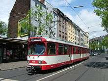  | |
| U-Bahn | ||
| Stadtbahn | ||
| Trams |
| |
| Trolleybuses | ||
| Suspension monorails | ||
| Other | ||
| ||
Coordinates: 51°09′11″N 14°59′12″E / 51.15306°N 14.98667°E
This article is issued from Wikipedia - version of the 11/16/2016. The text is available under the Creative Commons Attribution/Share Alike but additional terms may apply for the media files.
