Doppler on Wheels
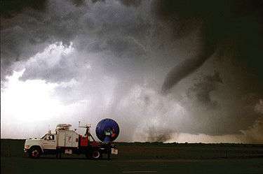
Doppler on Wheels (or DOW) is a fleet of radar trucks maintained by the Center for Severe Weather Research (CSWR) in Boulder, Colorado led by principal investigator Joshua Wurman, with the funding largely provided by the National Science Foundation (NSF). The DOW fleet and its associated Mobile Mesonet and Pod deployable weather stations are Lower Atmospheric Observing Facilities (LAOF) "National Facilities" supporting a wide variety NSF-sponsored research.
As of 2014, there are three operational DOWs of a total of eight constructed since 1995. Two are dual-polarization dual-frequency quick-scanning Doppler weather radars. The third, the Rapid-Scan DOW (rapid-DOW), is a multi-beam, multi-frequency rapid-scan radar capable of volumetric sampling at seven second intervals. Several instrumented mobile mesonet pickup trucks host in situ weather instrumentation on 3.5 metres (11 ft) masts to complement the remote sensing radars. These mobile mesonets also carry approximately 20 instrumented "PODS", which are ruggedized quickly deployable weather stations designed to survive inside tornadoes, tropical cyclones, and other adverse environments. The DOW fleet is sometimes accompanied by a Mobile Operations and Repair Center (MORC), a large van containing workstations for in-field coordination, data management, and equipment repair.
The DOW fleet has collected data in 200 tornadoes and inside the cores of 13 hurricanes. DOWs have been deployed to Europe twice, for the MAP and COPS field programs, and to Alaska twice for the JAWS-Juneau projects. DOWs have operated as high as 12,700 feet (3,900 m) on Bristol Head and at 10,000 feet (3,000 m) for the ASCII project at Battle Pass. Three DOWs, Mobile Mesonets and PODS were deployed for the OWLeS lake-effect snow study. The DOWs have participated in many field programs including: VORTEX, VORTEX2, COPS, MAP, ASCII, IHOP, SCMS, CASES, ROTATE, PAMREX, SNOWD-UNDER, FLATLAND, HERO, UIDOW, UNDEO.
The DOW fleet will be deployed to the upcoming nocturnal convection study, PECAN, in June–July 2015.
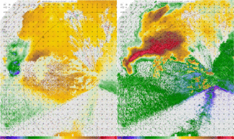
DOW data led to the discovery of sub-kilometer hurricane boundary layer rolls, which likely modulate wind damage and may play a key role in hurricane intensification. DOW data revealed the most intense winds ever recorded (Bridge Creek, 3 May 1999), and the largest tornadic circulation ever documented (also 3 May 1999 in Mulhall, OK), and made the first 3D maps of tornado winds and sub-tornadic vortex winds, and documented intense vortices within lake-effect snow bands. About 70 peer reviewed scientific publications have used DOW data.
The DOW fleet, PODS, and mobile mesonets have been featured on TV, including Discovery Channel's reality series Storm Chasers, National Geographic Channel's specials Tornado Intercept and The True Face of Hurricanes, and PBS's Nova episode "The Hunt for the Supertwister," and others.
