Dieppe, New Brunswick
| Dieppe | |||
|---|---|---|---|
| City | |||
| City of Dieppe Ville de Dieppe | |||
|
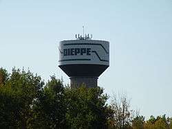
Dieppe Watertower (51 metres) Saint-Anselme | |||
| |||
|
Motto: "Constantia et virtute" (Latin) "By constancy and virtue" | |||
 Location of Dieppe in New Brunswick | |||
| Coordinates: 46°05′56″N 64°43′27″W / 46.098889°N 64.724167°W | |||
| Country |
| ||
| Province |
| ||
| County | Westmorland | ||
| Parish | Moncton | ||
| City | January 1, 2003 | ||
| Town | January 1, 1952 | ||
| Incorporated village | February 8, 1946 | ||
| Founded | 1730 | ||
| Government | |||
| • Type | Dieppe City Council | ||
| • Mayor | Yvon Lapierre | ||
| • MPs | Ginette Petitpas Taylor | ||
| • MLAs | Roger Melanson (Dieppe) | ||
| Area | |||
| • City | 54.11 km2 (19.25 sq mi) | ||
| • Urban | 98.388 km2 (37.988 sq mi) | ||
| • Metro | 117.309 km2 (45.293 sq mi) | ||
| Highest elevation | 45 m (148 ft) | ||
| Lowest elevation | 5 m (16 ft) | ||
| Population (2011/2014)[1][2] | |||
| • City | 23,310 | ||
| • Density | 299.9/km2 (776.7/sq mi) | ||
| • Urban | 107,068 | ||
| • Metro | 146,073 | ||
| Time zone | AST (UTC-4) | ||
| • Summer (DST) | ADT (UTC-3) | ||
| Postal code(s) | E1A | ||
| Area code(s) | 506 | ||
| NTS Map | 021I02 | ||
| GNBC Code | DADHJ | ||
| Highways |
| ||
| Website | www.dieppe.ca | ||

Dieppe is a city in Westmorland County, New Brunswick, Canada. It is New Brunswick's fourth most populous city with a history and identity that goes back to the eighteenth century. It was first incorporated as a town in 1952 and designated as a city in 2003. Its namesake comes from a commune in the Seine-Maritime department, a port on the English Channel, in France and was adopted by the citizens of the area in 1946 to commemorate the Second World War's Operation Jubilee, the Dieppe Raid of 1942.[3]
Dieppe is officially a francophone city; French is the native language of 73.9% of the population. A majority of the population reports being bilingual, speaking both French and English.[4] Residents generally speak French with a regional accent (colloquially called "Chiac") which is unique to southeastern New Brunswick. A large majority of Dieppe’s population were in favour of the by-law regulating the use of external commercial signs in both official languages, which is a first for the province of New Brunswick.[5][6][7] Dieppe is the largest predominantly francophone city in Canada outside Québec; while there are other municipalities with greater total numbers of francophones, they constitute a minority of the population in those cities.[8] Dieppe was one of the co-hosts of the first Congrès Mondial Acadien (Acadian World Congress) which was held in the Moncton region in 1994.
In 2011, Dieppe (City / Cité) had a population of 23,310, representing a percentage change of 25.6% from 2006. This compares to the national average growth of 5.9%. Land area is 54.11 square kilometres with a population density of 430.8 persons per square kilometre. This compares to the provincial land area of 71,377.18 square kilometres with a population density of 10.5 persons per square kilometre.[9]
Dieppe (City / Cité) is part of the census metropolitan area of Moncton, which is New Brunswick most populous estimated at 146,073 as of July 2014.
Government
Federal and provincial representatives
Provincial electoral districts Members of the 58th New Brunswick Legislative Assembly (2014), the governing house of the province of New Brunswick.[10][11]
- Dieppe - Roger Melanson
- Shediac Bay-Dieppe - Brian Gallant
Federal electoral districts Members of the 42nd Parliament of Canada (2015).[12] A section of southeast Dieppe is in the Beauséjour riding.
- Moncton—Riverview—Dieppe - Ginette Petitpas Taylor
- Beauséjour - Dominic LeBlanc
Geography
Dieppe is located on the Petitcodiac River. It forms the southeastern part of the Greater Moncton Area, which also includes the city of Moncton, the town of Riverview, Moncton Parish, Memramcook, Coverdale, and Salisbury.
Population
Dieppes' proper population increased significantly from 1971 to 1981 with the 1973 unification of the surrounding communities, i.e. Saint Anselme, Fox Creek/Dover and Chartersville. Being part of Moncton census metropolitan area, as of July 2014, Statistics Canada estimated the (CMA) had a population of 146,073 - making it the largest urban area in New Brunswick and the third largest in Atlantic Canada. The population has grown since the last official census in 2011 when the metropolitan area had 138,644 residents.[13] In addition, the Population Centre is estimated at 107,086, according to the 2011 census.[2]
| Historical population | ||
|---|---|---|
| Year | Pop. | ±% |
| 1951 | 3,402 | — |
| 1961 | 4,032 | +18.5% |
| 1971 | 4,277 | +6.1% |
| 1981 | 8,511 | +99.0% |
| 1986 | 9,084 | +6.7% |
| 1991 | 10,650 | +17.2% |
| 1996 | 12,497 | +17.3% |
| 2001 | 14,951 | +19.6% |
| 2006 | 18,565 | +24.2% |
| 2011 | 23,310 | +25.6% |
| 2016 | n/a | — |

Detailed mother tongue (2011 data)[4][14][15]
| Language | Population | Pct (%) |
|---|---|---|
| French | 16,565 | 73.93% |
| English | 5,335 | 23.81% |
| Non-official languages | 505 | 2.25% |
History
Acadians from the Petitcoudiac and Shepody (french Chipoudy) regions were the first pioneers to settle in the area and founded Sylvabreau in 1730, followed by the Melanson family at Ruisseau-des-Renards (Fox Creek) in 1746 and the LeBlanc and Boudreau families at Chartersville in 1776.[16] Preceding the arrival of Acadian settlers, the southern part of the province was inhabited by the Algonquin people.
Sylvabreau/Battle of the Petitcodiac
The Battle of the Petitcodiac was fought on September 2, 1755 during the British expulsion of the Acadians, after the capture of Fort Beauséjour. The Massachusetts-British force was soundly defeated by troops from Boishébert, Acadian militia, and First Nations' warriors. At the mouth of the Nacadie Creek (Hall's) settlements such as le Coude (The Bend), Sylvabreau and the surrounding hamlets were destroyed.[17] Even after these raids, Acadians returned to these villages and the numbers grew as the deportation from peninsular Nova Scotia continued, followed by the deportation from present-day Prince Edward Island and Cape Breton. Victory for the British occurred three years later (1758) during the Petitcodiac River Campaign (fr:La bataille du Cran) which resulted in the deportation of the Acadians that lived along the Petitcodiac River or had taken refuge there from earlier deportation operations.
From municipal/town/city designation
Dieppe was known as Upper Village after the Expulsion and was settled by the Surette, Maillet, and Thibodeau families, while Chartersville was called Leblanc's Village and also included members of the Boudreau's clan. Prior to 1800, Pierre Bourgeois had established himself on the (Ruisseau des Renards) Fox Creek salt marsh. Agriculture, forestry and some fishing sustained these Acadian families up until the mid-1800s, when shipbuilding and railways created employment opportunities for Acadians around the Moncton area. After a bridge was completed in 1867 at the mouth of Hall's Creek (Nacadie during the French settlement at Le Coude), a road was constructed that link the incorporated Town of Moncton's Westmorland Road (Main Street) to the (French Village) Dieppe area. This road went through farmland that had belong to the Leger family and intersected the old road (Acadie Avenue) that had taken travellers up and around Hall's Creek to the community of Lewisville to get to Moncton. By 1900, the little area around the intersection became known as Léger's Corner, and with the increasing traffic from the bridge, merchants became attracted to the corner and soon set up shops and services around the intersection. Prior to the First World War, a small residential development was erected, and the community continue to grow until the Second World War. Then a population explosion occurred. Léger's Corner received the largest influx of military personnel in southeastern New Brunswick. Ten thousand airmen (due to the airport) and their support staff arrived overnight in 1940, and soon temporary warehouses and housing were erected. When Léger's Corner became incorporated as a municipal village in 1946,[18] the community was renamed Dieppe, after a port in France on the English Channel, to honour the 913 Canadian servicemen who took part in the Dieppe Raid, the bloody landing by Allied soldiers, on August 19, 1942, during the Second World War. Then, part of Lakeburn was annexed in 1946 and Dieppe-East in 1948. A referendum (262 for, 232 against)[19] marginally favoured the village to incorporate as the Town of Dieppe in 1952. At that time, Dieppe had over 3,000 inhabitants within its boundaries. Growth continued unabated throughout the 1950s and 1960s as Dieppe annexed the villages of Saint-Anselme and Chartersville and the local service districts of Fox Creek-Dover(Upper Dover), the latter in 1973. With its rural expansion came a growth in population exceeding 8,500 in the 1981 census. Within the 1980s and early 1990s, the Town of Dieppe, like the rest of the region, went through an economic downfall which limited its growth in population. By 2001, the Greater Moncton area and Dieppe's economy flourished and with it came a population increment of nearly 15,000 in 2001 to over 23,000 in 2011. To preserve its heritage, culture and identity as a community in Southern New Brunswick, Dieppe opted to incorporate itself as a city on January 1, 2003. At that time it became New Brunswick's eighth incorporated city.
Maps of Dieppe from the 1960s shows Champlain Street below Acadie Avenue as Main Street and above the intersection as Airport Road.[20]
Neighbourhoods
Dieppe's geographic area is a direct union of Acadian parishes and villages such as:[21]
- Léger's Corner(French Village) - The downtown area has both retail and entertainment venues. Located near the City Hall are businesses, professionals, banking institutions, office buildings, restaurants, a public square, a cultural centre and a farmers market. The Dieppe Public Library, which is part of the New Brunswick Public Library System, has very modern facilities in the municipal building. The retail sector is predominantly located on Paul and Champlain Streets.[22]
- Chartersville (Leblanc's Village) (1776) Congregation Tiferes Israel Cemetery, has been a landmark in Chartersville since 1930. A small Protestant cemetery located on an adjacent lot contains only a few tombstones, several of which bear the names of members of the Charters family, descendants of Chartersville founder John Charters. The Charters gave their name to the former village of Chartersville.[23] Also, it is the home of the Our lady of Calvary Cemetery (Cimetere Notre Dame du Calvaire).
- Dieppe Boulevard sector - Located in the northeast area of Dieppe is a fast-growing commercial, business and residential area. This north-south connector stretches from Route 15 through the Dieppe Industrial Park, the Uptown area, the Fox Creek Golf community and several residential areas before ending at Melanson Road. It is less than a kilometre away from Greater Moncton International Airport.[22]
- Fox Creek/Dover (1746) - Up until the early 1980s, a local merchant Mother’s Own Bakery (Fox Creek), which subsequently was purchased by the former Ben’s Bakery.[24] housed its production and retail store in this district. Dover Road school was the educational institution for the region prior to the modernization of the NB School Act. In the early part of the 20th century, a religious sacramental - a Cross and 1755 Bicentennial Grotto - was erected at the intersection of Dover Road and Amirault Street.[25]
- Lakeburn (Le Brûlis-du-Lac)
- Painsec North
- Saint-Anselme (1820) Former village and the site of the Roman Catholic Church (Saint-Anselm), which the original wooden church that replace the chapel was erected in the early 19th century. The current stone structure was built in the early 1900s.
Education
Provincial public school systems
The following are a list of public schools in the city:
| School Name | Start | End | School District | Year Open | Max Enrolment | 2012 Enrolment | Notes |
|---|---|---|---|---|---|---|---|
| École Amirault | K | 2 | Francophone Sud | 1969 | 307 | ||
| École Sainte-Therèse | K | 2 | Francophone Sud | 1954 | 466 | New facilities and improvements were added in 2011.[26] | |
| École Anna-Malenfant | 3 | 5 | Francophone Sud | 1992 | 665 | ||
| Lou MacNarin School | K | 8 | Anglophone East | 1995 | 569 | ||
| École Mathieu-Martin | 9 | 12 | Francophone Sud | 1972 | 940 | ||
| École Carrefour de l'Acadie | 6 | 8 | Francophone Sud | 2006 | 572 | ||
| École boulevard Dieppe (Not officially named as of 2016) | 3 | 8 | Francophone Sud | 2018 | 1000 | Expected to be completed in 2018 to accommodate the growing population [27] |
Higher educational institutions
CCNB - Dieppe
- Le Collège communautaire du Nouveau-Brunswick-Campus de Dieppe is a francophone post-secondary higher education institution. CCNB-Dieppe opened to the public in 1987. Its English-language counterpart NBCC Moncton campus, situated on Mountain Road in Moncton, is the largest of the NBCC system. The province has two autonomous English and French community college corporations established under the 2010 New Brunswick Community Colleges Act.[28]
Parks and recreation
As of 2011, the community has some thirty parks and green spaces: one city park, fifteen district parks, seven neighbourhood parks, five green islands and a linear park with 20 km (12 mi) of trails. [29]
Festivals
- Dieppe Kite International—Kite flyers from several countries come to Dover Park in Dieppe. The first Dieppe Kite International took place in 2001 with the objective to offer an event that was original and of international calibre.[30]
- Dieppe Friendship Carnival—The annual friendship winter carnival started in the 1970s and features sleigh rides, skating on the pond, fiddle music, community breakfasts, canteen and more.[31]
Sports facilities
- Dieppe Aquatic and Sports Centre—Located at 111 Aquatique Street, Dieppe Aquatic and Sports Centre is a recreational facility, with three pools; a 25-meter six-lane pool for laps and various activities; a two-lane recreational pool for swimming and aquafitness sessions; and a second recreational pool with a slope from 0 to 1.4 meters equipped with water games, waterslides, a sitting and water jets area and a pirate’s boat for children.
- Arthur-J-LeBlanc Centre—The Arthur-J-LeBlanc Centre is a 595-seat multi-purpose arena.
Attractions
The city of Dieppe is a participant in the province of New Brunswick's local historic places program, funded by the government of Canada through the historic places initiative.[32]
Monuments
- Honoré Melanson Village—Once known as the community district of Fox Creek, this site was established by Paul Honoré Melanson and his wife Marie-Josephe Breau in 1748. This couple resisted the 1755 Deportation and sought exile in Louisiana in 1764. The site commemorated with a plaque is located at the intersection of Marguerite, Amirault, and Fox Creek streets.[33]
- Odyssée—This monument, located at "Le coude" on the Petitcodiac river, tells the story of Acadian resistance on the banks of the river, after deportation orders were issued. Joseph Broussard and his friends used Guerrilla warfare tactics to avoid deportation.[16]
- Veterans Cenotaph—The Veterans’ Monument was erected by the Dieppe Military Veterans Association in 1981. It is located at 333 Acadie Avenue. The veterans wanted a memorial erected in honour of the soldiers who sacrificed their lives on the beaches of Dieppe, France, and elsewhere during all of the wars in which Canada and its allies took part. In 2000, a granite base was installed in honour of World War I, World War II and Korean War, as well as the contribution of peacekeepers. A base bearing the words “Nous nous souviendrons / Lest we forget” with a poppy on each side was added at the back of the monument.[16]
Prominent buildings
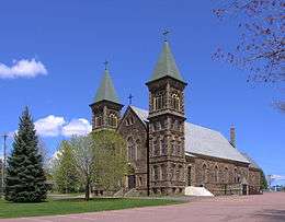
- Saint Anselme Church is a Romanesque Revival Catholic church located at 1014 Amirault Street in the Saint-Anselme sector of Dieppe. Built at the turn of the 20th century, this rectangular cut-stone structure has a gable roof and two square towers on the front façade. Saint-Anselme Church is designated a Local Historic Place for its religious role and for its architecture. It illustrates the Acadians’ respect for religious and spiritual matters. The church replaced one that had been built in 1839. Originally, a chapel built in 1812, located west of the current Chapelle Street, was used for worship until 1839. Construction work on Saint-Anselme Church began in 1898. The blessing of the church took place on October 11, 1904.[34][35]
- Saint Teresa of the Infant Jesus Church is a large stone and concrete structure with a bell tower and Gothic windows. This modern interpretation of Gothic Revival religious architecture is located at the corner of Sainte-Thérèse Street and Acadie Avenue in Dieppe. The church highlights the importance of the Catholic Church in the community life of Leger Corner. In 1930, this parish broke away from the parish of Saint-Anselme and built its first church, made of wood. That building was converted into a community centre in 1950 when this new stone church was opened to the public. Sainte-Thérèse Church is recognized for its architecture. This place of worship was built by contractor Abbey Landry of Memramcook from 1949 to 1950. This building exhibits a modern interpretation of traditional Gothic Revival religious architecture. In its Gothic windows, magnificent stained-glass panels illustrate the life of patron Saint Theresa of the Child Jesus, a Carmelite nun who died at Lisieux, France in 1897, at the age of 24.[36]
- Joseph-Doiron House is located at 1150 Amirault Street. Built in 1847, the Joseph-Doiron House was once the meeting and celebration place for the Village of St-Anselme. Its basement also served as a school. Joseph Doiron was a literate notary who had been educated in Memramcook by Father Louis Brodeur.[33]
Shopping
- Champlain Place—The largest single building shopping centre in Atlantic Canada by floor space (also the largest single-story mall east of Montreal) opened in 1974 and currently has over 150 stores and services with five anchor tenants. An expansion to the mall was added in 1986 with the anchor store Sobeys. In addition, a major interior and exterior renovation of the mall was completed in November 2008.[37] The original anchor store Sears was established in 1969.
- Bass Pro Complex—The Complex includes a Starbucks Coffee, Cineplex Theatre, Chapters Bookstore and a Bass Pro Shop. The shopping complex is adjacent to Champlain Place and it is owned and operated by Cadillac Fairview.[38]
Media
- L'Étoile Dieppe - Édition Dieppe, provides news and information to the francophone population of New Brunswick's Dieppe area. L'Étoile - Édition Dieppe is published every Thursday and it is owned by Brunswick News.
Transportation
Greater Moncton International Airport
The Greater Moncton International Airport was officially opened in 2002 by Queen Elizabeth II. It is 6 km from downtown Dieppe and 10 km from Moncton.[40] Moncton Flight College, the largest private flight school in Canada, is at the airport. MFC has trained over 16,000 pilots from around the world since 1929.[41]
Rapid Transit
Codiac Transpo is the city of Moncton, Dieppe and town of Riverview's public transit system. Within Codiac transpo 47 bus fleet, three services Dieppe's main arteries and subdivisions seven days a week; in addition to its numerous fleet of Codiac Buses at the Champlain Place terminal.[42] Services to the inner city has been offered since 1984. Services is provided seven days a week with late evening routes and modified weekend hours. In 2012, the route scheduling was modified to reflect the Codiac Transpo services. With it came a change transit destination and new route numbers.
- 90 Express Dieppe
- 91 Champlain
- 92 Amirault
Roads and Bridges
- Fox Creek Bridge—Inaugurated in 1982, the current bridge replaced the low rise structure which was built in 1924. Some facts regarding the Fox Creek bridge from the June 8, 1982 edition of L'Evangeline newspaper.[43]
(The present site of the Fox Creek bridge holds historical facts which dates back to the 1800s. A geographical map of the region made by the English forces shows families with the Amirault surnames living in the area. Later, Acadians built earthen dykes (aboiteau) at Pointe des renards to prevent flooding, which also served as "bridges" for both banks of the river. In 1924, a low rise bridge was constructed that flooded every two to three years.)
- Halls Creek Bridge—The first Hall's Creek bridge in Moncton was built in 1867, which link the city with Leger's Corner via the Westmorland Road (Main Street). The current structure at the Wheeler Boulevard intersection opened in 1982.[44][45]
- In the archives at the McCord Museum of Canadian History in Montreal there is a postcard with the inscription of the "Fox Creek Bridge". This postcard was mailed from Montreal Quebec on 23 September 1913 to a Miss Breau at 28 rue Victoria Street Moncton.[46] A closer look seemingly reveals it to be the Halls Creek Bridge. It is unknown when the picture was taken, however a small portion of downtown Moncton of the time is visible on the postcard.[47]
Both bridges are on Route 106, which follows the original provincial Route 2 from Quebec to Nova Scotia. Through the late 1950s and 1960s, a number of bypasses and realignments, mostly two-lane, were built to improve Route 2 with federal Trans-Canada Highway funds. The first, built in the 1950s, was around Moncton. The old road became Route 2A, but it was renumbered Route 6 in 1965 and 106 in 1984 during a reclassification of provincial highways. It is still signed as Route 6 at the corner of Cameron St. and Main St. (the current Route 106) in downtown Moncton - [48] At Moncton, Route 106 runs through Main Street and passes Hall's Creek bridge up to the intersection in centre-ville Dieppe connecting Amirault Street, which leaves the city to the southeast en route to Memramcook. The aforementioned route had a significant impact for the future community of Dieppe has it linked southeast New Brunswick to Nova Scotia prior to the completion of the new Trans-Canada Highway. In addition, it attracted new residents to cultivate the land and build dwellings throughout the 19th and 20th centuries.
Notable people
Sister cities
Bordering communities
 |
Moncton / (Lewisville) | Moncton (Harrisville) | Lakeville / Painsec Junction | |
| Moncton (Downtown Moncton) / (Riverview / Lower Coverdale (over Petitcodiac River)) | |
Painsec / Greater Lakeburn / Meadow Brook | ||
| ||||
| | ||||
| Stoney Creek (over Petitcodiac River) | Memramcook | Memramcook |
See also
- Media in Greater Moncton
- List of communities in New Brunswick
- Codiac Transpo
- Greater Moncton
- List of events in Greater Moncton
- Chiac
References
- ↑ "Stats Canada Population and Dwelling Count". Statistics Canada.
- 1 2 "New Brunswick (Canada): Province, Urban Areas and Population Centers - Population Statistics in Maps and Charts". Retrieved 29 June 2016.
- ↑ "DIEPPE RAID,OPERATION JUBILEE,WW2 RAID ON DIEPPE,". Retrieved 29 June 2016.
- 1 2 http://www12.statcan.gc.ca/census-recensement/2011/dp-pd/prof/details/page.cfm?Lang=E&Geo1=CSD&Code1=1307045&Geo2=CD&Code2=1307&Data=Count&SearchText=dieppe&SearchType=Begins&SearchPR=01&B1=All&Custom=&TABID=1
- ↑ http://www.dieppe.ca/doc/download/Dieppe%20Survey%202011.pdf
- ↑ Dieppe Signage, Companies facing fines.
- ↑ http://www.officiallanguages.nb.ca/newsroom_view.cfm?news_id=148&page_type=1
- ↑ http://www12.statcan.ca/census-recensement/2006/dp-pd/prof/92-591/details/page.cfm?Lang=E&Geo1=CSD&Code1=3502036&Geo2=PR&Code2=35&Data=Count&SearchText=Clarence-Rockland&
- ↑ https://www12.statcan.gc.ca/census-recensement/2011/as-sa/fogs-spg/Facts-csd-eng.cfm?LANG=Eng&GK=CSD&GC=1307045
- ↑ New Brunswick general election, 2014#Southeastern
- ↑ "Provincial Electoral Districts". Retrieved 29 June 2016.
- ↑ "Current Members of Parliament". Retrieved 29 June 2016.
- ↑ "Metro Moncton Population Growing Steadily - The Bend - CKNI". Retrieved 29 June 2016.
- ↑ Community Profiles from the 2006 Census, Statistics Canada - Census Subdivision
- ↑ fr:Dieppe (Nouveau-Brunswick)#Démographie
- 1 2 3 "Historic Places and Monuments - City of Dieppe". Retrieved 29 June 2016.
- ↑ "Academia.edu - Documents in Battle of the Petitcodiac - Academia.edu". Retrieved 29 June 2016.
- ↑ Machum, Lloyd A (1965). A History of Moncton: Town and city 1885-1965. Moncton: Moncton Publishing Company. p. 402.
- ↑ L'Evangéline - Recherche d'archives de Google Actualités 21 mai 1982
- ↑ "McCully's New Brunswick Historic Aerial Photographs 1931-1939". Dan Soucoup/ Richard Thorne McCully, 2005.
- ↑ http://www.dieppe.ca/history.cfm
- 1 2 "ExpansionDieppe.ca". Retrieved 29 June 2016.
- ↑ "HistoricPlaces.ca - HistoricPlaces.ca". Retrieved 29 June 2016.
- ↑ "Past News". Retrieved 29 June 2016.
- ↑ List of historic places in Westmorland County, New Brunswick
- ↑ Official opening of École Sainte-Thérèse
- ↑ http://www2.gnb.ca/content/gnb/en/news/news_release.2016.04.0331.html
- ↑ "Bill 30 - New Brunswick Community Colleges Act". Retrieved 29 June 2016.
- ↑ "Dieppe Commandos Hockey Club powered by GOALLINE.ca". Retrieved 29 June 2016.
- ↑ http://www.dieppe.ca/cerfvolant/about_us.cfm
- ↑ "City of Dieppe". Retrieved 29 June 2016.
- ↑ http://www.dieppe.ca/doc/download/Patrimoine1.pdf
- 1 2 http://www.dieppe.ca/monuments_historic_sites.cfm
- ↑ "HistoricPlaces.ca - HistoricPlaces.ca". Retrieved 29 June 2016.
- ↑ Leger, Marc. "Unit� pastorale Marie Reine de l'Acadie - Accueil". Retrieved 29 June 2016. replacement character in
|title=at position 5 (help) - ↑ "HistoricPlaces.ca - HistoricPlaces.ca". Retrieved 29 June 2016.
- ↑ Champlain Place
- ↑ Palais Crystal Palace
- ↑ Bass Pro Complex (Dieppe)
- ↑ "Greater Moncton International Airport specs". Retrieved 29 June 2016.
- ↑ "Home". Retrieved 29 June 2016.
- ↑ "Home". Retrieved 29 June 2016.
- ↑ "L'Evangéline - Recherche d'archives de Google Actualités". Retrieved 29 June 2016.
- ↑ "X14048 - Fox Creek Bridge, Moncton, New Brunswick - Postcard - - McCord Museum". Retrieved 29 June 2016. horizontal tab character in
|title=at position 51 (help) - ↑ File:Tidal bore.jpg
- ↑ "Musée McCord Museum -". Retrieved 29 June 2016.
- ↑ "Musée McCord Museum - Fox Creek Bridge, Moncton, N.B.". Retrieved 29 June 2016.
- ↑ http://the506.com/roads/NB/106.html
External links
| Subdivisions | |
|---|---|
| Cities | |
| |
Coordinates: 46°05′56″N 64°43′27″W / 46.09889°N 64.72417°W