Dang Deukhuri District
| Dāng Deukhuri District दाङ जिल्ला | |
|---|---|
| District | |
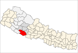 Dang (red) | |
| Country | Nepal |
| Region | Mid-Western (grey) |
| Zone | Rapti (darker grey) |
| Headquarters | Ghorahi |
| Area | |
| • Total | 2,955 km2 (1,141 sq mi) |
| Population (2011) | |
| • Total | 548,141[1] |
| Time zone | NPT (UTC+5:45) |
| Main language(s) | Nepali, Tharu |
Coordinates: 28°0′N 82°16′E / 28.000°N 82.267°E
Dang is located in Inner Terai, some 410 km west of the capital city, Kathmandu in Province No. 5 in midwestern Nepal. The district covers 2,955 km² with a population (2011) of 548,141.[1] Ghorahi (formerly Tribhuvannagar) is the district's administrative center and largest city while Tulsipur to the west is a transportation hub and Rapti Zone's administrative center.There are numerous temples and gumbas in Dang district. Dang, Ghorahi is a proposed capital of Rapti Lumbini Province (Province 5)based on the Constitution of Nepal 2015.
Geography and climate
This district consists of the larger easterly and upstream portions of the parallel Inner Terai valleys of Dang and Deukhuri, plus enclosing ranges of hills and mountains. Downstream, both valleys cross into Banke District, Bheri Zone.
To the south, the district borders Uttar Pradesh, a state in india, Nepal's neighboring country—specifically the Balarampur and Shravasti districts of Awadh. Because the international border follows the southern edge of the outermost Siwalik foothills called the Dudhwa Range, there is no Outer Terai extending onto the main Ganges Plain inside this district. The permeable geology of the Siwaliks does not support moisture retention or soil development, so they are covered with unproductive scrub forest.
The Dudhwas rise steeply to a crest at about 700 meters, then slope more gradually into the Deukhuri Valley, down to 250 meters elevation at the Rapti River. The Dudhwas extend more than 100 km, causing the Rapti to detour west around them before turning southeast down the main trend of the plains into India. Deukhuri's climate is nearly tropical and it is well watered by the river, as well as possessing abundant groundwater.
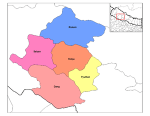
North of Deukhuri Valley, the Dang Range rises as high as 1,000 meters with passes at about 700 meters. The Dang Valley lies north of these hills, drained by the Babai River tributary to the Ghaghara (Karnali). Valley elevations range from 600 meters along the Babai with alluvial slopes gradually rising northward to 700 meters along the base of the Mahabharat Range. The district then extends upslope to the crest of the Mahabharats at 1,500 to 1,700 meters elevation. The bordering districts to the north are Pyuthan, Rolpa, and Salyan.
| Climate zone[2] | Elevation Range | % of Area |
|---|---|---|
| Lower Tropical | below 300 meters (1,000 ft) | 18.1% |
| Upper Tropical | 300 to 1,000 meters 1,000 to 3,300 ft. |
69.9% |
| Subtropical | 1,000 to 2,000 meters 3,300 to 6,600 ft. |
12.0% |
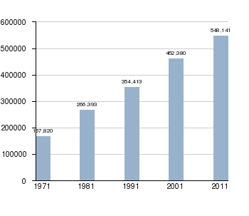
Population by Census 1971-2011[3][4]
History and prehistory
Hand axes and other artifacts dated to early Paleolithic (1.8 million to 100,000 years ago) have been found in alluvial deposits along the Babai River in Dang Valley. Archeologists classify these as Acheulean, i.e. 'second-generation' toolmaking that succeeds the very oldest Olduwan. There are more numerous less ancient archeological sites dating to the Upper Paleolithic/Late Pleistocene (about 50,000 to 10,000 years ago). These are also along the Babai, as well as in Deukhuri Valley (Rapti River) adjacent and south of Dang Valley.[5] [6]
Throughout historic times and probably earlier the Dang and Deukhuri valleys were home to indigenous Tharu people.
About 1760 AD all these kingdoms were annexed by the Shah Dynasty during the reunification of Nepal, except Tulsipur lands south of the Siwalik Hills were not taken. Since Dang was somewhat higher, cooler, better-drained and therefore less malarial than most Inner Terai valleys in Nepal, it was settled to some extent by Shah and Rana courtiers and other Nepalese. Deukhuri was more of a Tharu enclave until DDT was introduced to control the disease-bearing Anopheles mosquito in the 1950s.
Transportation
East West Highway —the main east-west highway across Nepal— follows Deukhuri Valley, passing Bhalubang bazar at the upper end and Lamahi downstream. From Bhalubang, branch roads lead up the Rapti River into Pyuthan and Rolpa Districts. From Lamahi there are roads north across the Dang Range to Ghorahi, and south over the Dudhwas to Koilabas, which used to be an international trade centre earlier. The East West highway which passes through the Lamahi joints the Banke district leading Kohalpur. Roads from Ghorahi lead to Rolpa district and the Swargadwari pilgrimage site. From Tulsipur a motorable road goes north into Salyan District.
At Tarigaun, all-weather Dang Airport has scheduled connections to other cities in Nepal.
Demography
The dry and agriculturally unproductive Dudhwa range creates a buffer zone between the divergent cultures of the plains of Uttar Pradesh and the Inner Terai. Deukhuri was severely malarial before the late 1950s when DDT came into use to suppress mosquitos so that Tharu people who had evolved resistance managed to live in isolation from more developed and avaricious cultures of the plains to the south and the hills to the north. Although road development further reduced Deukhuri's isolation by the 1980s, the valley retains some of its Garden of Eden charm with its lazy river, thick jungle alternating with rice paddies, surrounding hills in the middle distance, and unique peoples.
Dang Valley is higher, less tropical, drier and less malarial than Deukhuri. Despite poorer soil and more seasonal streamflow, its healthier climate made it more attractive to settlers from outside even before the introduction of DDT.
Since the early 1990s activist groups have been attempting to eradicate the practice of child indentured servitude among the Tharu, many of whom sold young daughters to wealthy families in urban areas.[7]
This region has majority of people of the Tharu ethnicity. The steep, virtually uninhabited southern slopes of the Mahabharat Range are another cultural buffer zone between traditional Tharu lands and the culturally distinct Middle Hills where Nepali is the dominant language, the homeland of Bahuns and Chhetris. The Kumal (potter) ethnic group is also semi-indigenous.
Towns and villages
- Amritpur
- Baghmare, Bela, Bijauri
- Dhanauri, Dharna, Diruwa
- Ghorahi Municipality, Gadhawa, Gangaparaspur, Goltakuri, Gobardiya
- Halwar, Hansipur, Hekuli,
- Kabhre, Koilabas, Kanchanpur
- Parseni
- Bakulahi
- Lalmatiya, Laksmipur, Loharpani, Lamahi Municipality
- Manpur
- Panchakule, Pawan Nagar, Phulbari, Purandhara,
- Rajpur, Rampur,
- Saigha, Satbariya, Saudiyar, Shantinagar, Srigaun, Sisahaniya, Sonpur, Syuja
- Tripur Municipality, Tulsipur Municipality
- Sunbarsa
- Kothari
- Pachahiya
- Mahadewa
- Sonpur
- Mauli
- Malmala
Patu Khola
- Pawan Nagar (Kumal Gaun, Sunpur, Chhote, Hapurkot, Damargaun, Bayale, Hirapur, Devisthan, Bhamake)
- Bhalubang
Historic, cultural and archaeological sites
Heritage sites in Dang Deukhuri District include:[8]
- Ambikeshwari Temple, Ghorahi
- Ratnanath Mandir, Ghorahi
- Barakune Daha, Ghorahi
- Sawarikot
- Ghordaura
- Chhilli kot, Chhilli Kot Gupha, Chameri Gupha
- Dharapani, 10 km south of Ghorahi
- Devikot
- Hanuman Temple
- Kalimai Temple, Kalika Temple
- Malika Temple, Mulkot Cave
- Ram Janaki Temple
- Sirasthan, Srigaun Temple, Sukaura Mound
- Bagar Baba mandir, Rihar
- Taptakunda Shivalaya, Mamisauri mandir, Rihar
- Shiva Mandir, Dhankhola,
- Shiva Cave, Dhankhola,
- Mata Malmala Devi
- Tuhi valley
- Suikot Temple
- Devisthan Mandir [Pawannagar, Bhamake]
- Jakhera Tal Temple
- Purandhara water fall
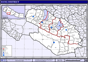
Maps
- Ministry of Federal Affairs and Local Development[9] has downloadable district maps based on a detailed and comprehensive GIS database:
- Besides the United Nations/Nepal map of districts and VDCs shown above, their Map Centre[10] has a downloadable PDF version adding municipalities, roads and water detail:
- "Dang District" (PDF) (Map). Retrieved Jan 31, 2014. Missing or empty
|title=(help)
- "Dang District" (PDF) (Map). Retrieved Jan 31, 2014. Missing or empty
- From 1992 to 2002 a definitive series of large scale topographic maps were surveyed and published through a joint project by Government of Nepal Survey Department[11] and Finland's Ministry for Foreign Affairs contracting through the FinnMap consulting firm.[12] Japan International Cooperation Agency[13] substituted for FinnMap mainly in Lumbini Zone with one sheet showing the easternmost part of Dang-Deukhuri.
- Topographic sheets at 1:25,000 scale covering 7.5 minutes latitude and longitude map the Terai and Middle Mountains including all of this district. JPG scans can be downloaded here:[14]
- These sheets cover Dang-Deukhuri District:
- 2782 1B "Amiliya" (2005)
- 2782 1D "Sunpathari Naka" (1997)
- 2782 2A "Rihar" (1998)
- 2782 2B "Satbariya" (1998)
- 2782 2C, 6A "Jangrahawa Mahatiniya" (1998)
- 2782 2D "Bela" (1998)
- 2782 3A "Atthaise" (1998)
- 2782 3B "Hasipur" (1998)
- 2782 3C "Lamahi" (2005)
- 2782 3D "Lalmatiya" (2005)
- 2782 4A "Bangesal" (1997)
- 2782 4C "Bhaluban" (1997)
- 2782 6B "Siriya Naka" (1998)
- 2782 7A "Koilabas" (2005)
- 2782 7B "Jawabairath" (1999)
- 2882 9D "Shitalpati" (1998)
- 2882 13A "Hamsapur" (1998)
- 2882 13B "Panchakule" (1998)
- 2882 13C "Bairiya Kusum" (2005)
- 2882 13D "Hekuli" (1998)
- 2882 14A "Tulsipur" (1999)
- 2882 14B "Dubrin" (1999)
- 2882 14C "Bijauri" (1999)
- 2882 14D "Ghorahi" (1998)
- 2882 15A "Holeri" (1999)
- 2882 15C "Bach Pokhara" (1998)
- 2882 15D "Swargadwari" (1999)
- (JICA) 097-11 "Shiwagadhi" (1993)
References
- 1 2 "National Population and Housing Census 2011(National Report)" (PDF). Central Bureau of Statistics. Government of Nepal. November 2012. Retrieved November 2012. Check date values in:
|access-date=(help) - ↑ The Map of Potential Vegetation of Nepal - a forestry/agroecological/biodiversity classification system (PDF), Forest & Landscape Development and Environment Series 2-2005 and CFC-TIS Document Series No.110., 2005, ISBN 87-7903-210-9, retrieved Nov 22, 2013
- ↑
- "Districts of Nepal". Statoids. Gwillim Law. Retrieved January 23, 2014.
- ↑
- National Population and Housing Census 2011, Volume 3 (PDF). Kathmandu, Nepal: Government of Nepal, Central Bureau of Statistics. January 2014. Retrieved January 23, 2014.
- ↑ Corvinus, Gudrun (1989). "A handaxe assemblage from western Nepal" (PDF). Quartär (International Yearbook for Ice Age and Stone Age Research). 39/40: 155–173. Retrieved December 8, 2013.
- ↑ Chauthan, Parth R. (May 2003). "An Overview of the Siwalik Acheulian & Reconsidering Its Chronological Relationship with the Soanian - A Theoretical Perspective". Assemblage (7). Retrieved December 8, 2013.
- ↑ Desperate plight of Nepal 'slave girls' BBC News, 2 March 2007
- ↑ Bhandari, B. (1997). Inventory of heritage sites in Nepal. Kathmandu: IUCN Nepal.
- ↑ "Ministry of Federal Affairs and Local Development". Government of Nepal. Retrieved February 21, 2014.
- ↑ "Map Centre". United Nations, Nepal Information Platform. Retrieved February 4, 2014.
- ↑ "Government of Nepal, Survey Department". Retrieved February 4, 2014.
- ↑ "Land Administration & Management, Mapping, Surveying and Aerial Photography, Major Reference Projects" (PDF). FinnMap. Retrieved February 4, 2014.
- ↑ "Japan International Cooperation Agency". Retrieved February 4, 2014.
- ↑ "Nepal-Topo Maps". PAHAR Mountains of Central Asia Digital Dataset. Retrieved Jan 31, 2014.
External links
| Wikimedia Commons has media related to Dang Deukhuri District. |

