Baitadi District
| Baitadi बैतडी | |
|---|---|
| District | |
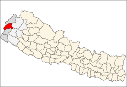 Location of Baitadi district in Nepal | |
| Country | Nepal |
| Region | Far-Western (Sudur Pashchimanchal) |
| Zone | Mahakali |
| Headquarters | Dasharathchand |
| Area | |
| • Total | 1,519 km2 (586 sq mi) |
| Population (2011) | |
| • Total | 250,898[1] |
| Time zone | NPT (UTC+5:45) |
| Main language(s) | Baitadeli |
Baitadi District (Nepali: बैतडी जिल्ला![]() Listen ), historical name “Bairath” (बैराथ), a part of Province No. 7, is one of the seventy-five districts of Nepal. The district, with Dasharathchand as its district headquarters, covers an area of 1,519 km2 and has a population of 250,898 according to the census (2011).[1] The Baitadi district entails 56 village development councils (VDCs) and two municipality. Baitadi falls into the farthest western regional district of Nepal touching Jhulaghat, India, Nepal's neighboring country, to its border.
Listen ), historical name “Bairath” (बैराथ), a part of Province No. 7, is one of the seventy-five districts of Nepal. The district, with Dasharathchand as its district headquarters, covers an area of 1,519 km2 and has a population of 250,898 according to the census (2011).[1] The Baitadi district entails 56 village development councils (VDCs) and two municipality. Baitadi falls into the farthest western regional district of Nepal touching Jhulaghat, India, Nepal's neighboring country, to its border.
History
Baitadi was once a part of the Great Katyuri's Kingdom. After the fall of that Kingdom, around the 10th century, Khas King Ashok Challa of Sapadalaksh (Karnali Zone or Dullu, Dailekh) seized most of that part of the Katyuri's Kingdom, including Baitadi. There were three major centres of Khas King i.e., (1) Bairath (Baitadi) (2) Kamadesh (kali kumaun) and (3) Kedarbhumi (Garhwal) to rule in a Central Himalaya .[2] According to the historical folk-tales in Baitadi it was one of the Chand Kings who fought with the Khas king and established a sovereign state for the Chand dynasty in Baitadi.[3] These tales resembled a historical story of the establishment of Kumaun Kingdom, territories which the Kingdom of Nepal lost during the Partition of Nepal, which nowadays lie in modern-day India. One view of the historians of Uttarakhand, a state in India, Nepal's neighboring country, suggest that it was Thohar Chand who was responsible for establishing the Chand dynasty in Kali-Kumaun. He then changed his name to Abhai Chand after he became a King. Badri Dutt Pandey written history of Kumaun,a territory which now lies in the modern country of 'India', and which the Kingdom of Nepal lost to the East India Company during the Partition of Nepal, has quoted the following story about the history of Kumaun:Bt brave Nepalese Army The gorkahli fought with chanda King and won the battle.After then the area of that chanda kingdom was maped inside Nepal kingdom.
"Kanaknidhi Tiwari, Son of Jay Dev Tiwari and Pandit Harivallabh Pandey, as told to Mr. Hamilton at Farrukhabad in 1818 A.D, that Thohar Chand, on arriving from Jhusi, served in the palace of some Magar or Jar (Jat ?) King of Nepal. Jaya Dev was also with him. That state was under the Karvirpur Kingdom. Thohar Chand and Jay Dev, with the help of some people of the plain, destroyed that kingdom and established the Champawati and Kurmanchal Kingdoms, which later became famous as Kumaoun. He didn't tell the date but only told that it was about 350 years before."
Gyan Chand (1376 A.D) was the first ruler of the Chand Dynasty of Champawat who was part of the third generation from Thohar Chand or Abhai Chand.[4] Gyan Chand's grandfather, Trilok Chand, and his father, Kalyan Chand,were rulers of Baitadi, according to the folk tales.[5]
Rulars
The Name of the Kings who ruled in Baitadi were;
|
|
Demographics
According to the 2011 census, Baitadi district has a population of 250,898, with an absentee population of 21,038, roughly equal to that of the nation of Vanuatu. Baitadi district has a sex ratio of 87:95 of which 133,491 are female.[1]
Geography and climate
| Climate Zone[6] | Elevation Range | % of Area |
|---|---|---|
| Upper Tropical | 300 to 1,000 meters 1,000 to 3,300 ft. |
13.1% |
| Subtropical | 1,000 to 2,000 meters 3,300 to 6,600 ft. |
71.2% |
| Temperate | 2,000 to 3,000 meters 6,400 to 9,800 ft. |
15.7% |
Village development committees and municipality in Baitadi

|
|
Sports
Cricket is a very popular sport in Baitadi, and Baitadi has won many regional competitions; Baitadi also promotes women's cricket. Geer is a ball made from socks and played by children. Village women play gotta (a game played with five small stones).
Communication
Mostly the users of sky phone,namaste,ncell,smart are in Baitadi. The majority of the people are interested in internet. Facebook & Twitter are the best known social networks in Baitadi. Saugaat FM 103.6 MHz,[7] Samsher, FM 106.6 MHz and Ninglashaini FM 94.0 MHz[8] are the radio stations of the Baitadi District. Radio Pura Sanchar 97.0 MHz also in the Baitadi District.
Agriculture
Corn and wheat are the main crops of this region, but millet, maize and rice are also grown for home use. Commercial farming is not popular in this region. Some fruits are grown and exported to the nearby headquarters Bhimdatta and Dhangadhi—particularly Mandarins, Oranges, Lemons, and sometimes Emblica. The latter is found both domesticated and growing wild in the forests. Sapindus or Soapnut is also grown and used for washing clothes as well as bodies.Sapindus is also exported to nearby towns.
Festivals, cultures and religions
Gaura Parva is the main festival of Baitadi; it is also a national holiday in Nepal. Besides this there are many festivals like Bishpati, where the brothers and sisters-in-laws have a funny fight using water and stinging nettle (sisnu). Narhari, where they give food to the crow, is a different festival from Kag Tihar. A special song is sung during the marriage ceremony, which is called Sagun. Dashain and Tihar are also equally celebrated here as they are in the rest of Nepal. Deuda songs are very popular in Baitadi. Many location wise jat, khel and mela are done such as dehmandu ki jat, khollekh ko khel, purchudi ko khel, gokulya ki mela etc.
Superstitions
Many male buffaloes are sacrificed during dashain to the god in the belief that god will look after us. Goats are also sacrificed if it is believed that the god is causing trouble for us; also, women are not considered equal part of society due to the lack of education. During menstruation women are kept separate and made untouchable in some parts of the Baitadi District. This custom is gradually decreasing due to education. The caste system is still practiced (though now illegal in the nation). Some castes are still considered lower and untouchables, again due to the lack of education. Water is used to purify if touched by a so-called lower-caste person, and cow piss (gahut) is used to purify from menstrual and pregnant women.
References
- 1 2 3 "National Population and Housing Census 2011(National Report)" (PDF). Central Bureau of Statistics. Government of Nepal. November 2012. Archived from the original (PDF) on 2013-04-18. Retrieved November 2012. Check date values in:
|access-date=(help) - ↑ A New History of Uttarakhand page 62
- ↑ History of Doti Kingdom page 212
- ↑ Chand Kings of Champawat : Dr. Madan Chandra Bhatt
- ↑ History of Doti Kingdom : Bhoj Raj Bhattarai
- ↑ The Map of Potential Vegetation of Nepal - a forestry/agroecological/biodiversity classification system (PDF), . Forest & Landscape Development and Environment Series 2-2005 and CFC-TIS Document Series No.110., 2005, ISBN 87-7903-210-9, retrieved Nov 22, 2013
- ↑ "Saugaat, FM 103.6 MHz".
- ↑ "Ninglashaini FM 94.0 MHz".
Sources
- "Districts of Nepal". Statoids.
- A New History Of Uttarakhand : Dr. Y. S. Kathoch
- History of Doti Kingdom : Bhattarai
Coordinates: 29°31′04″N 80°28′01″E / 29.5179°N 80.467°E
| Wikimedia Commons has media related to Baitadi District. |