Conguillío Lake
| Conguillío Lake | |
|---|---|
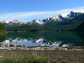 The lake with Sierra Nevada in the background. | |
| Location | La Araucanía Region |
| Coordinates | 38°38′S 71°38′W / 38.633°S 71.633°WCoordinates: 38°38′S 71°38′W / 38.633°S 71.633°W |
| Primary outflows | Underground outflow[1] |
| Basin countries | Chile |
| Surface area | 7.8 km2 (1,900 acres)[1] |
| Surface elevation | 1,122 m (3,681 ft) above sea level |
Conguillío Lake is a lake located in the La Araucanía Region of Chile, within the Conguillío National Park. The lake was formed by the damming of the Trufultruful River caused by a lava flow from the Llaima volcano.[2]
References
- 1 2 "Parque Nacional Conguillío" (in Spanish). CONAF. Retrieved 2013-02-02.
- ↑ (Spanish) Sernageomin. "Volcán Llaima". Archived from the original on 2007-04-29. Retrieved 2013-02-02.
| Rivers |  | |
|---|---|---|
| Waterfalls |
| |
| Lakes |
| |
This article is issued from Wikipedia - version of the 11/29/2016. The text is available under the Creative Commons Attribution/Share Alike but additional terms may apply for the media files.