Charlton, New York
| Charlton, New York | |
|---|---|
| Town | |
 Charlton, New York Location within the state of New York | |
| Coordinates: 42°57′1″N 73°59′27″W / 42.95028°N 73.99083°W | |
| Country | United States |
| State | New York |
| County | Saratoga |
| Area | |
| • Total | 32.8 sq mi (85.0 km2) |
| • Land | 32.8 sq mi (85.0 km2) |
| • Water | 0.0 sq mi (0.1 km2) |
| Elevation | 663 ft (202 m) |
| Population (2000) | |
| • Total | 3,954 |
| • Density | 120.5/sq mi (46.5/km2) |
| Time zone | Eastern (EST) (UTC-5) |
| • Summer (DST) | EDT (UTC-4) |
| ZIP code | 12019 |
| Area code(s) | 518 |
| FIPS code | 36-13926 |
| GNIS feature ID | 0978812 |
Charlton is a town in Saratoga County, New York, USA. The population was 3,954 at the 2000 census. The town is named after a notable physician.
The Town of Charlton is located in the southwest part of the county and is north of Schenectady.
History
The region was first settled around 1680 by travelers from the small village of Charlton, located in Worcestershire, UK. The town was formed in 1792 from the Town of Ballston immediately after Saratoga County was established. The town was previously known as "Freehold" due to the number of settlers from New Jersey.
Notable residents
- John W. Taylor, Congressman, Speaker of the House.
Geography
According to the United States Census Bureau, the town has a total area of 32.8 square miles (85 km2), of which, 32.8 square miles (85 km2) of it is land and 0.04 square miles (0.10 km2) of it (0.06%) is water.
The south town line is the border of Schenectady County, and the west town line is the border of Montgomery County.
New York State Route 67 (Amsterdam Road) is an east-west highway which intersects New York State Route 147, a north-south highway, north of West Charlton.
Demographics
| Historical population | |||
|---|---|---|---|
| Census | Pop. | %± | |
| 1820 | 1,953 | — | |
| 1830 | 2,023 | 3.6% | |
| 1840 | 1,933 | −4.4% | |
| 1850 | 1,902 | −1.6% | |
| 1860 | 1,752 | −7.9% | |
| 1870 | 1,607 | −8.3% | |
| 1880 | 1,474 | −8.3% | |
| 1890 | 1,175 | −20.3% | |
| 1900 | 1,109 | −5.6% | |
| 1910 | 1,030 | −7.1% | |
| 1920 | 914 | −11.3% | |
| 1930 | 978 | 7.0% | |
| 1940 | 1,063 | 8.7% | |
| 1950 | 1,298 | 22.1% | |
| 1960 | 3,024 | 133.0% | |
| 1970 | 3,772 | 24.7% | |
| 1980 | 4,019 | 6.5% | |
| 1990 | 3,984 | −0.9% | |
| 2000 | 3,954 | −0.8% | |
| 2010 | 4,133 | 4.5% | |
| Est. 2014 | 4,189 | [1] | 1.4% |
As of the census[3] of 2000, there were 3,954 people, 1,429 households, and 1,204 families residing in the town. The population density was 120.5 people per square mile (46.5/km²). There were 1,464 housing units at an average density of 44.6 per square mile (17.2/km²). The racial makeup of the town was 98.46% White, 0.28% African American, 0.15% Native American, 0.32% Asian, 0.10% from other races, and 0.68% from two or more races. Hispanic or Latino of any race were 0.96% of the population.
There were 2,429 households out of which 34.7% had children under the age of 18 living with them, 75.4% were married couples living together, 5.3% had a male householder with no wife present, and 15.7% were non-families. 12.9% of all households were made up of individuals and 6.6% had someone living alone who was 65 years of age or older. The average household size was 2.74 and the average family size was 3.00.
In the town the population was spread out with 25.2% under the age of 18, 5.4% from 18 to 24, 24.2% from 25 to 44, 31.9% from 45 to 64, and 13.3% who were 65 years of age or older. The median age was 42 years. For every 100 females there were 95.2 males. For every 100 females age 18 and over, there were 96.0 males.
The median income for a household in the town was $63,396, and the median income for a family was $66,250. Males had a median income of $47,813 versus $30,208 for females. The per capita income for the town was $27,924. About 0.6% of families and 1.2% of the population were below the poverty line, including none of those under age 18 and 3.3% of those age 65 or over.
Communities and locations in Charlton
- Blue Corners – A hamlet.
- Charlton – A hamlet south of the town center on County Roads 51 and 52. The Charlton Historic District was listed on the National Register of Historic Places in 1976.[4]
- Harmony Corners – A hamlet in the northeast corner of the town on NY-67.
- Holbrook Corners – A hamlet near the north town line, located on NY-67.
- Komar Park – A hamlet near the southeast part of Charlton..
- Tucker Heights – A hamlet by the south town line.
- West Charlton – A hamlet northwest of Charlton, located on NY-147. The West Charlton United Presbyterian Church was listed on the National Register of Historic Places in 1998.[4]
- Wheeler Estates – A location in the southeast part of Charlton.
References
- ↑ "Annual Estimates of the Resident Population for Incorporated Places: April 1, 2010 to July 1, 2014". Retrieved June 4, 2015.
- ↑ "Census of Population and Housing". Census.gov. Archived from the original on May 11, 2015. Retrieved June 4, 2015.
- ↑ "American FactFinder". United States Census Bureau. Archived from the original on 2013-09-11. Retrieved 2008-01-31.
- 1 2 National Park Service (2009-03-13). "National Register Information System". National Register of Historic Places. National Park Service.
External links
Coordinates: 42°56′00″N 73°58′08″W / 42.93333°N 73.96889°W
Municipalities and communities of Saratoga County, New York, United States | ||
|---|---|---|
| Cities | 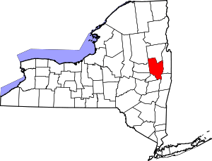 | |
| Towns | ||
| Villages | ||
| CDPs | ||
| Other hamlets | ||
| Footnotes | ‡This populated place also has portions in an adjacent county or counties | |