Boyero, Colorado
| Boyero, Colorado | |
|---|---|
| Unincorporated community | |
 Boyero, Colorado Location within the state of Colorado | |
| Coordinates: 38°56′11″N 103°16′29″W / 38.93639°N 103.27472°WCoordinates: 38°56′11″N 103°16′29″W / 38.93639°N 103.27472°W | |
| Country |
|
| State |
|
| County | Lincoln County |
| Elevation[1] | 4,721 ft (1,439 m) |
| Time zone | MST (UTC-7) |
| • Summer (DST) | MDT (UTC-6) |
| ZIP Code | 80821 (Hugo)[2] |
Boyero (Spanish: oxherd) is an unincorporated community in Lincoln County, Colorado, United States. The U.S. Post Office at Hugo (ZIP Code 80821) now serves Boyero postal addresses.[2]
A post office called Boyero was established in 1902, and remained in operation until 1973.[3] The community was named for the local cattle industry, "Boyero" meaning "bull pen" in Spanish.[4]
Geography
Boyero is located at 38°56′11″N 103°16′29″W / 38.93639°N 103.27472°W (38.936446,-103.274746).
See also
References
| Wikimedia Commons has media related to Boyero, Colorado. |
- ↑ "US Board on Geographic Names". United States Geological Survey. 2007-10-25. Retrieved 2008-01-31.
- 1 2 "ZIP Code Lookup". United States Postal Service. January 3, 2007. Archived from the original (JavaScript/HTML) on September 3, 2007. Retrieved January 3, 2007.
- ↑ "Post offices". Jim Forte Postal History. Archived from the original on 6 March 2016. Retrieved 24 June 2016.
- ↑ Dawson, John Frank (1954). Place names in Colorado: why 700 communities were so named, 150 of Spanish or Indian origin. Denver, CO: The J. Frank Dawson Publishing Co. p. 10.
Municipalities and communities of Lincoln County, Colorado, United States | ||
|---|---|---|
| Towns | 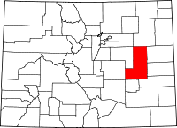 | |
| Unincorporated communities | ||
This article is issued from Wikipedia - version of the 11/6/2016. The text is available under the Creative Commons Attribution/Share Alike but additional terms may apply for the media files.