Blair, Nebraska
| Blair, Nebraska | |
|---|---|
| City | |
|
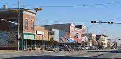
Washington Street | |
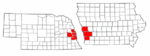
 Location of Blair within Washington County and Nebraska | |
| Coordinates: 41°32′44″N 96°8′4″W / 41.54556°N 96.13444°WCoordinates: 41°32′44″N 96°8′4″W / 41.54556°N 96.13444°W | |
| Country | United States |
| State | Nebraska |
| County | Washington |
| Area[1] | |
| • Total | 5.51 sq mi (14.27 km2) |
| • Land | 5.49 sq mi (14.22 km2) |
| • Water | 0.02 sq mi (0.05 km2) |
| Elevation | 1,070 ft (326 m) |
| Population (2010)[2] | |
| • Total | 7,990 |
| • Estimate (2013[3]) | 7,990 |
| • Density | 1,455.4/sq mi (561.9/km2) |
| Time zone | Central (CST) (UTC-6) |
| • Summer (DST) | CDT (UTC-5) |
| ZIP codes | 68008-68009 |
| Area code(s) | 402 |
| FIPS code | 31-05350 |
| GNIS feature ID | 0827479[4] |
| Website | blairnebraska.org |

Blair is a city in and the county seat of Washington County, Nebraska, United States.[5] The population was 7,990 at the 2010 census. Blair is a part of the Omaha-Council Bluffs Metropolitan Statistical Area.
History
Blair was platted in 1869 when the Sioux City and Pacific Railroad was extended to that point.[6] It was named for railroad magnate John Insley Blair, who was credited with bringing the railroad to town.[7] Within its first year, Blair was designated county seat.[6] Blair was incorporated as a city in 1872.[8]
Geography
Blair is located at 41°32′44″N 96°8′4″W / 41.54556°N 96.13444°W (41.545562, -96.134383).[9] According to the United States Census Bureau, the city has a total area of 5.51 square miles (14.27 km2), of which, 5.49 square miles (14.22 km2) is land and 0.02 square miles (0.05 km2) is water.[1]
Blair has its own hospital, the Memorial Community Hospital, and being the county seat, also has a courthouse located in town.

Demographics
| Historical population | |||
|---|---|---|---|
| Census | Pop. | %± | |
| 1870 | 494 | — | |
| 1880 | 1,317 | 166.6% | |
| 1890 | 2,069 | 57.1% | |
| 1900 | 2,970 | 43.5% | |
| 1910 | 2,584 | −13.0% | |
| 1920 | 2,702 | 4.6% | |
| 1930 | 2,791 | 3.3% | |
| 1940 | 3,289 | 17.8% | |
| 1950 | 3,815 | 16.0% | |
| 1960 | 4,931 | 29.3% | |
| 1970 | 6,106 | 23.8% | |
| 1980 | 6,418 | 5.1% | |
| 1990 | 6,860 | 6.9% | |
| 2000 | 7,512 | 9.5% | |
| 2010 | 7,990 | 6.4% | |
| Est. 2015 | 7,975 | [10] | −0.2% |
| U.S. Decennial Census[11] 2013 Estimate[3] | |||
2010 census
As of the census[2] of 2010, there were 7,990 people, 3,110 households, and 2,005 families residing in the city. The population density was 1,455.4 inhabitants per square mile (561.9/km2). There were 3,351 housing units at an average density of 610.4 per square mile (235.7/km2). The racial makeup of the city was 96.4% White, 0.8% African American, 0.3% Native American, 0.3% Asian, 0.1% Pacific Islander, 1.0% from other races, and 1.1% from two or more races. Hispanic or Latino of any race were 2.9% of the population.
There were 3,110 households of which 33.3% had children under the age of 18 living with them, 50.5% were married couples living together, 10.6% had a female householder with no husband present, 3.3% had a male householder with no wife present, and 35.5% were non-families. 30.3% of all households were made up of individuals and 13.4% had someone living alone who was 65 years of age or older. The average household size was 2.40 and the average family size was 3.01.
The median age in the city was 36 years. 24.9% of residents were under the age of 18; 11.7% were between the ages of 18 and 24; 23.9% were from 25 to 44; 24.3% were from 45 to 64; and 15.3% were 65 years of age or older. The gender makeup of the city was 47.9% male and 52.1% female.
2000 census
As of the census of 2000, there were 7,512 people, 2,871 households, and 1,891 families residing in the city. The population density was 1,617.3 people per square mile (625.1/km²). There were 3,033 housing units at an average density of 653.0 per square mile (252.4/km²). The racial makeup of the city was 97.43% White, 0.44% African American, 0.29% Native American, 0.33% Asian, 0.27% Pacific Islander, 0.33% from other races, and 0.91% from two or more races. Hispanic or Latino of any race were 1.34% of the population.
There were 2,871 households out of which 33.9% had children under the age of 18 living with them, 52.8% were married couples living together, 10.1% had a female householder with no husband present, and 34.1% were non-families. 29.1% of all households were made up of individuals and 14.4% had someone living alone who was 65 years of age or older. The average household size was 2.43 and the average family size was 3.02.
In the city the population was spread out with 24.9% under the age of 18, 13.8% from 18 to 24, 25.6% from 25 to 44, 20.4% from 45 to 64, and 15.4% who were 65 years of age or older. The median age was 35 years. For every 100 females there were 90.9 males. For every 100 females age 18 and over, there were 88.2 males.
As of 2000 the median income for a household in the city was $41,214, and the median income for a family was $52,114. Males had a median income of $36,839 versus $25,452 for females. The per capita income for the city was $19,240. About 6.2% of families and 8.4% of the population were below the poverty line, including 11.4% of those under age 18 and 10.5% of those age 65 or over.
Points of interest
- Part of the Nebraska Statewide Arboretum collection
- Blair was home to the now defunct Dana College
- From 1896-1954, Blair was home to Trinity Seminary, a school of the United Evangelical Lutheran Church
- Blair is located along the historic Lincoln Highway
Notable people
- Kent Bellows - artist
- Bill Danenhauer - professional wrestler
- Mike Hollingshead - photographer
- Mick Mines - Nebraska state senator
- Otto Diller Schmidt - US Navy Medal of Honor recipient
- Tom Seaton - baseball player
- Paul Simon - Democratic Congressman, Senator, and presidential candidate
- Rod Whitaker - novelist
See also
References
- 1 2 "US Gazetteer files 2010". United States Census Bureau. Archived from the original on 2012-01-24. Retrieved 2012-06-24.
- 1 2 "American FactFinder". United States Census Bureau. Retrieved 2012-06-24.
- 1 2 "Population Estimates". United States Census Bureau. Retrieved 2014-07-17.
- ↑ "US Board on Geographic Names". United States Geological Survey. 2007-10-25. Retrieved 2008-01-31.
- ↑ "Find a County". National Association of Counties. Archived from the original on 2011-05-31. Retrieved 2011-06-07.
- 1 2 "Blair, Washington County". Center for Advanced Land Management Information Technologies. University of Nebraska. Retrieved 24 August 2014.
- ↑ Chicago and North Western Railway Company (1908). A History of the Origin of the Place Names Connected with the Chicago & North Western and Chicago, St. Paul, Minneapolis & Omaha Railways. p. 44.
- ↑ Buss, William Henry; Osterman, Thomas T. (1921). History of Dodge and Washington Counties, Nebraska, and Their People. American Historical Society. p. 402.
- ↑ "US Gazetteer files: 2010, 2000, and 1990". United States Census Bureau. 2011-02-12. Retrieved 2011-04-23.
- ↑ "Annual Estimates of the Resident Population for Incorporated Places: April 1, 2010 to July 1, 2015". Retrieved July 2, 2016.
- ↑ United States Census Bureau. "Census of Population and Housing". Archived from the original on May 11, 2015. Retrieved October 16, 2013.
External links
Municipalities and communities of Washington County, Nebraska, United States | ||
|---|---|---|
| Cities | ||
| Villages | ||
| Townships | ||
| CDP | ||
| Unincorporated communities | ||
| Former community | ||
| Footnotes | ‡This populated place also has portions in an adjacent county or counties | |
Metropolitan area of Omaha–Council Bluffs | ||||||||
|---|---|---|---|---|---|---|---|---|
| Primary Cities |
|  | ||||||
| Cities over 10,000 (per 2010 Census) |
| |||||||
| Cities of 5,000 to 10,000 (per 2010 Census) |
| |||||||
| Cities of 1,000 to 5,000 (per 2010 Census) |
| |||||||
| Census-designated places |
| |||||||
| Cities and villages of fewer than 1,000 (per 2010 Census) |
| |||||||
| Counties |
| |||||||